Northumberland's Avalon. June 26.
Gadgie Dave, piles of stones analyst and expert, assures me that John of Gaunt, builder of Dunstanburgh Castle, was an Arthurian fantasist and that the now ruined castle was built as his own private little Avalon. Excavations suggest the site was inhabited in Iron Age and Roman times. Construction of the present castle started with the digging of the moat in 1314 and most of it was finished by 1380, it didn't last long.
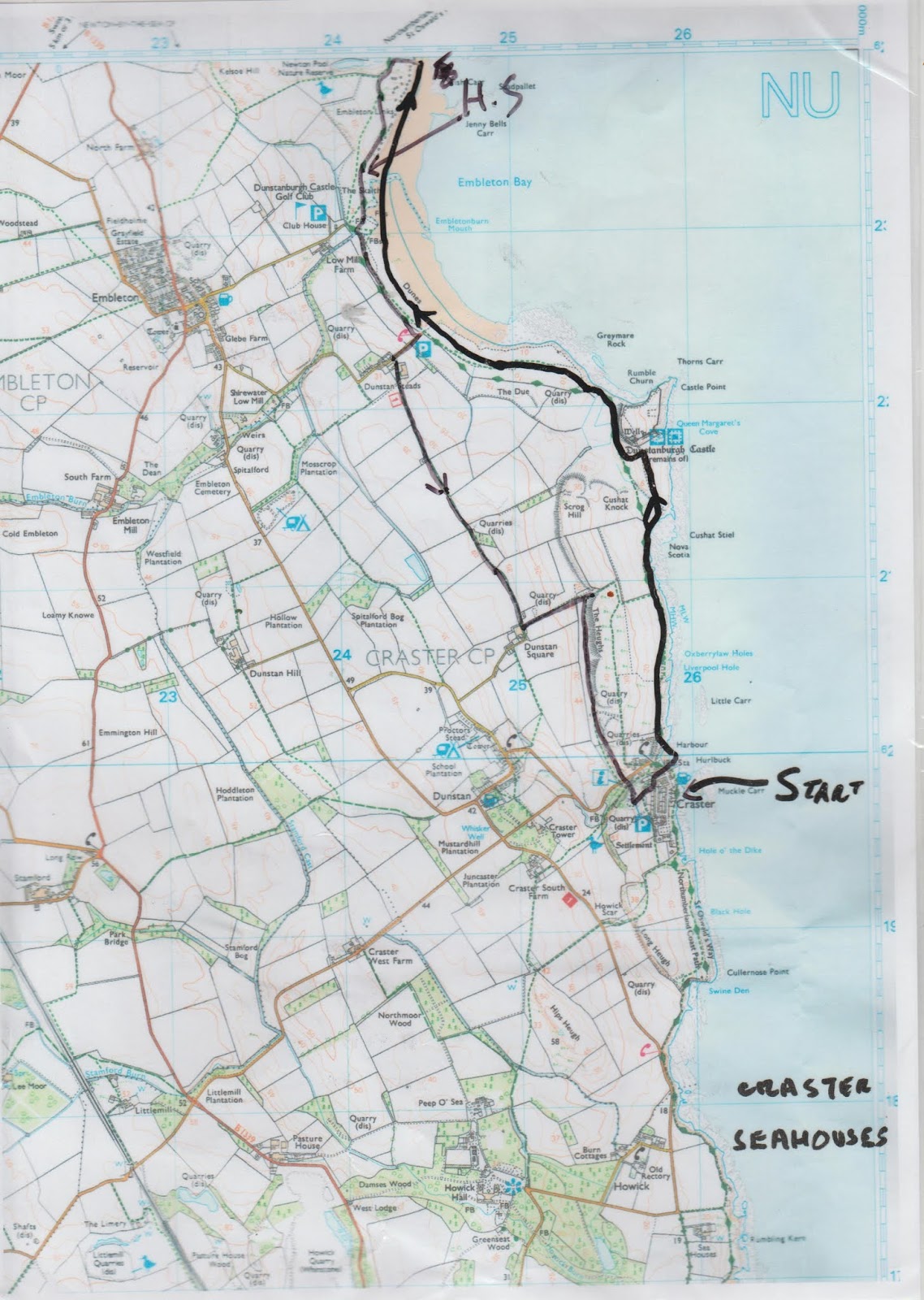
Today's walk from Craster, another well known and popular day out passes the noble ruins.
Most of the walk, about 95% is covered by OS Explorer 332 Alnwick and Amble, the other 5% is on OS Explorer 340, Holy Island and Bamburgh.
There are six of us: Dave, Brian, Margaret, John H., John Ha. and me.
To get to Craster head north on the A1, turn off just north of Alnwick and head east, following signs to the fishing village. In an old quarry on the right, as you enter the village , is a large car park. It is not very expensive, £4 for a whole day. Unfortunately because of the current restrictions we are not sharing cars.
 Even the cars are socially distanced. How obedient we northerners are
In the first, smaller, car park there is a footpath on the right that goes down to the village. We took it and headed for the Shoreline Café.
 The Shoreline, Craster. Although closed for eating inside the Shoreline is doing a great take away service. We got tea/coffee/ snack and carried them past the Jolly Fisherman pub and sat overlooking the harbour.

 Two views of the harbour. The large concrete block is a left over from the days when stone from the quarry (now the car park) was brought down to the harbour on a ropeway.
Quick breakfast and off we went. In front of a row of houses, through a gate and across the fields to Dunstanburgh Castle, 14th century.

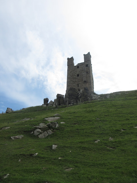
Gatehouse and Lilburn Tower, not much more is left of John's Arthurian castle.
Beyond the castle the footpath passes between a golf course and the sea.
 For neogeologists, this is an anticline, and a fine one too. Sometimes you get groups of bored A level students here having it all explained by the PE teacher/ geographer.
And on the left is a pill box left over from WW2. It was thought that an invasion could take place in the north and the coast still has concrete blocks on the shore and several of these boxes, designed to keep the Wehrmacht out.
 WW2 pill box
Not far beyond the pill box we headed down from the dunes to walk on the sands of Embleton Bay.
There has been some controversy of late because during lockdown, and persuaded by some hot weather, thousands of people took to Bournemouth on the south coast for a day by the sea. The powers that be disapproved, quite rightly, it broke the social distancing rules but;
 Embleton Bay, Northumberland June 26th

Bournemouth. June 24th
Where would you rather be?
The bay curves gently for a bout a mile. There are a number of small holiday chalets on the dunes. Round the corner at the top of the bay and we were in Newton by the Sea, usually a Herbie Spot.
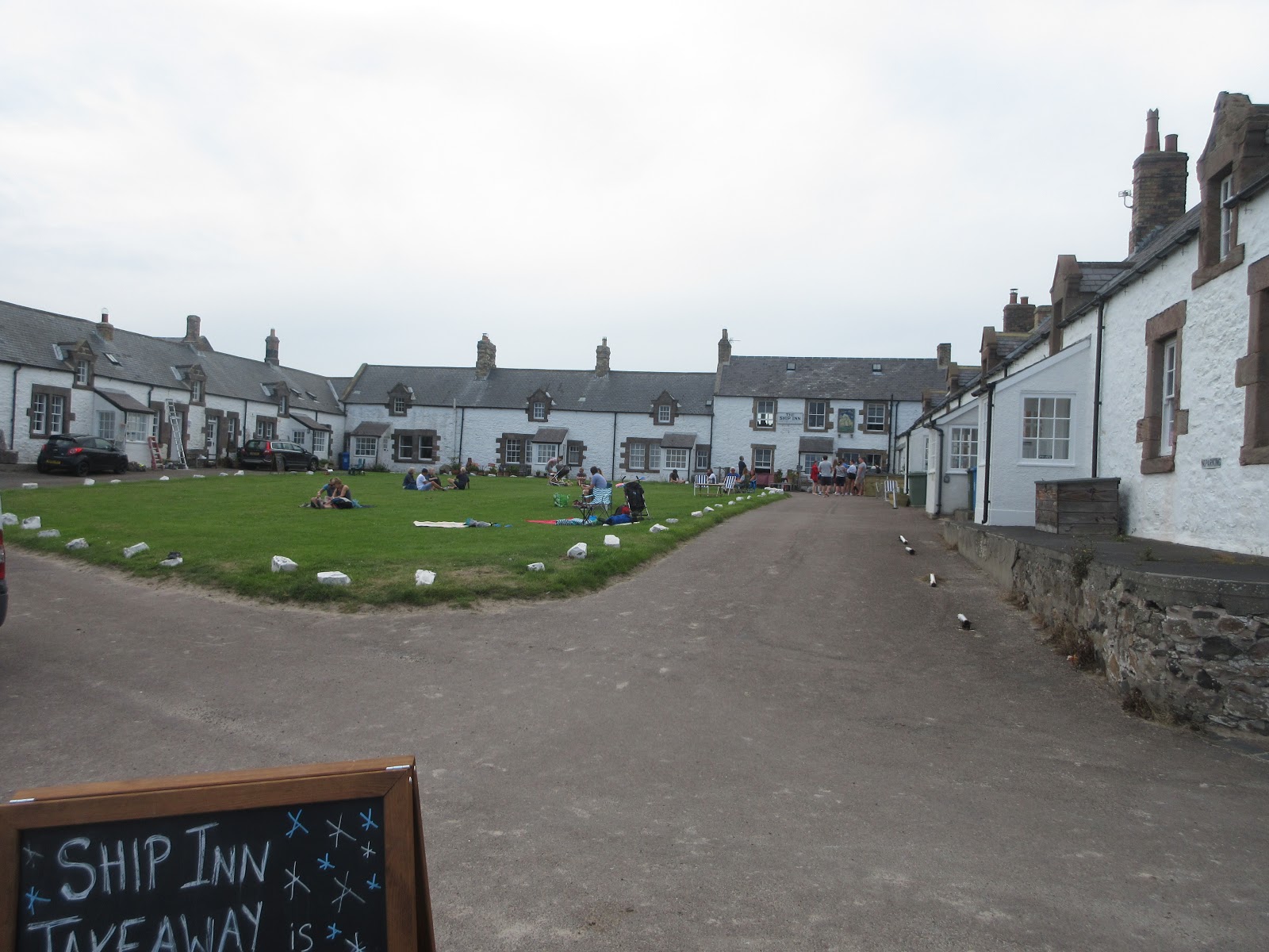
 Newton by the Sea. The Ship Inn has a good reputation for food and has its own brewery. No dining or drinking inside because of ….. but the pub was doing a roaring trade in take away beer, sandwiches and other snacks.
We walked round the back of the little square of houses and followed the footpath to Newton Pond Nature Reserve. Like Philadelphia it was closed.
 Normally a Herbie Spot, eat and observe at the same time but it closed because of.....
Through the trees we saw Mallards, Canadas, grey lags and even an avocet on or near the water. No heron.
We carried on on the footpath until we reached the golf course and there we found a suitable spot to Herbie. Still no sharing but I believe two of the party had intended to bring sharing things but forgot them. Can't complain, we all forget.
The footpath goes through the dunes, past several of the chalets and heads towards the club house near Low Mill Farm. We walked along the edge of the course, sometimes on the grass, sometimes on a narrow brambly footpath until we arrived at the gate to walk up to Dunstan Steads.
From the farm here a concrete strip, again supposedly a left over from WW2 crosses fields to the farm at Dunstan Square.


 On the way we passed some friendly looking cows, a lime kiln and an unusual pillboxmade from concrete sandbags.
At Dunstan Square we split. Four of us took the footpath east to the path behind the Heughs and walked back to Craster. Brian and Margaret carried on to Dunstan and beyond before returning to Craster.
 Approaching Craster behind the heughs.
Still no pubs open to sit in and have a drink without queuing so we went home.
 Contains OS data, copyright. Crown copyright and database right 2020
A SORT OF MATRIX
steps miles
NAK 22059 8.7 (thought I'd fixed it)
Dave's NAK 1 17090 7.82
""""""""""""2 17114 7.83
SM 17175 7.86
OUTDOOR GPS 7.5
Brian and Margaret 12
A few more pictures of the walk, which is a lovely gentle stroll out.


Gadgie Dave, piles of stones analyst and expert, assures me that John of Gaunt, builder of Dunstanburgh Castle, was an Arthurian fantasist and that the now ruined castle was built as his own private little Avalon. Excavations suggest the site was inhabited in Iron Age and Roman times. Construction of the present castle started with the digging of the moat in 1314 and most of it was finished by 1380, it didn't last long.
Today's walk from Craster, another well known and popular day out passes the noble ruins.
Most of the walk, about 95% is covered by OS Explorer 332 Alnwick and Amble, the other 5% is on OS Explorer 340, Holy Island and Bamburgh.
There are six of us: Dave, Brian, Margaret, John H., John Ha. and me.
To get to Craster head north on the A1, turn off just north of Alnwick and head east, following signs to the fishing village. In an old quarry on the right, as you enter the village , is a large car park. It is not very expensive, £4 for a whole day. Unfortunately because of the current restrictions we are not sharing cars.

In the first, smaller, car park there is a footpath on the right that goes down to the village. We took it and headed for the Shoreline Café.


Quick breakfast and off we went. In front of a row of houses, through a gate and across the fields to Dunstanburgh Castle, 14th century.


Gatehouse and Lilburn Tower, not much more is left of John's Arthurian castle.
Beyond the castle the footpath passes between a golf course and the sea.

And on the left is a pill box left over from WW2. It was thought that an invasion could take place in the north and the coast still has concrete blocks on the shore and several of these boxes, designed to keep the Wehrmacht out.

Not far beyond the pill box we headed down from the dunes to walk on the sands of Embleton Bay.
There has been some controversy of late because during lockdown, and persuaded by some hot weather, thousands of people took to Bournemouth on the south coast for a day by the sea. The powers that be disapproved, quite rightly, it broke the social distancing rules but;


Bournemouth. June 24th
Where would you rather be?
The bay curves gently for a bout a mile. There are a number of small holiday chalets on the dunes. Round the corner at the top of the bay and we were in Newton by the Sea, usually a Herbie Spot.
We walked round the back of the little square of houses and followed the footpath to Newton Pond Nature Reserve. Like Philadelphia it was closed.

Through the trees we saw Mallards, Canadas, grey lags and even an avocet on or near the water. No heron.
We carried on on the footpath until we reached the golf course and there we found a suitable spot to Herbie. Still no sharing but I believe two of the party had intended to bring sharing things but forgot them. Can't complain, we all forget.
The footpath goes through the dunes, past several of the chalets and heads towards the club house near Low Mill Farm. We walked along the edge of the course, sometimes on the grass, sometimes on a narrow brambly footpath until we arrived at the gate to walk up to Dunstan Steads.
From the farm here a concrete strip, again supposedly a left over from WW2 crosses fields to the farm at Dunstan Square.


At Dunstan Square we split. Four of us took the footpath east to the path behind the Heughs and walked back to Craster. Brian and Margaret carried on to Dunstan and beyond before returning to Craster.

Still no pubs open to sit in and have a drink without queuing so we went home.
A SORT OF MATRIX
steps miles
NAK 22059 8.7 (thought I'd fixed it)
Dave's NAK 1 17090 7.82
""""""""""""2 17114 7.83
SM 17175 7.86
OUTDOOR GPS 7.5
Brian and Margaret 12
A few more pictures of the walk, which is a lovely gentle stroll out.


