Translate

Saturday 25 November 2023

We are the Boulmer generation

 We are the Boulmer generation.    November 24th.

After last week's country walk in the mud we are heading for the coast again on a familiar walk starting at a good cafe  and heading for the sea. The walk is from Longhoughton,  drive north to Alnwick,  east towards the coast and watch for signs, or as an alternative follow the Northumberland Coastal route.

There are five of us out today, down  from last week. and the team to fight the cold north wind is Brian, Margaret, Harry, Wylam John and me.

There is a small parking space near the Running Fox cafe. The space has a stone column and a bench.

The Running Fox does great breakfasts and coffee

The walk is covered by OS Explorer 332 Alnwick and Amble.

Positive comment on car park photo last week, very encouraging. This week: Longhoughton mini park.

Having fuelled up and booted up the five of us set off down the road to Low Stead and beyond.

St Peter and St Paul. Longhoughton. 11th century beginnings
                  Harry's library on the road to Low Stead. You take or leave a book and leave a donation.
Beyond Low Stead, where there is some parking, we arrived at the coast at Howdiemont Sands, greeted by a cold north wind off the sea and a spectacular view of breakers. The England Coast Path heads south for us, walkers can use a firm track or walk across the grassy dunes. We took to the dunes until we reached the tiny seaside village of Boulmer.

There are several of these artistic pieces on the wall between Howdiemont Sands and Boulmer.
Beyond Boulmer we continued on the footpath over the dunes. On other occasions we have walked on the beach but an unusually high tide made that impossible. 
Having walked through a caravan park and passed some fine new cottages, built for holiday homes, we came to the golf course. Mindful of the warning about flying balls we walked the edge of the course to the clubhouse at Foxton Hall. Visitors welcome for food and drink but we carried on, still well above the sea until we spotted a bench with a good view over a golf course and called a Herbie.
                A view from a Herbie Spot. (Skinny whips, cookies and apple crumble and savory bun from Mrs A)
Too cold to hang around we carried on down to the beach at Alnmouth, walked the coastal path round the bottom of the town to the bridge over the River Aln. Once across the bridge we took the footpath through a sports ground to the village of Lesbury.

St Mary's Lesbury, 13th century but much restored.
WE continued along the main street, passing the long closed pub, to the roundabout, turned right and walked to the railway bridge. Under the bridge and up the track past the old station building. 

Late afternoon, long shadows at Lesbury old station.
A few hundred yards beyond the railway buildings we took the footpath across fields to a firm farm track. After about a half mile we turned right down another track. Not far down this one we followed a grassy footpath, passing a tumbled down cottage and going under the railway. Here we turned left, walked over fields and soon arrived back at Longhoughton.
On the way home we called at the Ridley Arms in Stannington for beer, tea or wine.

Contains OS data, copyright. Crown copyright and database right 2023.

The walk is about 11 miles, coastal views and country and easy going.
                      Foot and mouth
                      Cold North Sea
                                     Boulmer

                               WW2 relic
                         Alnmouth Bay


Saturday 18 November 2023

MURDER MOST FOUL

 Murder most foul and a Scout camp November 17th

VERY, VERY MUDDY

After a damp and breezy week the forecast suggests it will be a good day for a walk. Today's  exercise starts at Newbrough, a village west of Hexham and on the north bank of the  Tyne.

Head west on the A69, just beyond Hexham turn north for Warden, cross the river and continue west to the village of Newbrough, one of the few in England to have a town hall. Parking is on the roadside.                                                                                                                                                                           The OS OL 43 Hadrian's  Wall covers the walk and could be useful.                                                       By all means stop at Brockbushes on the Corbridge roundabout for morning coffee and food.

Newbrough is one of the few villages in England to have a town hall. We parked outside it, not one for the calendar. There are some convenient benches for booting up though, and toilets.

Once ready we walked west along the road, crossed a bridge and turned right through a gate to follow a muddy, leaf strewn footpath which climbed steadily, turned right, crossed a minor road, crossed a soggy field and arrived at another minor road. 


                  Muddy and leaf covered, but posted.

Heading north we walked steadily uphill until we came to a fork in the road. Taking the right fork, with a sign saying Carr Edge, we went on to that farm, went round the buildings and crossed a watery and hoof chewed up field to  a wood. (mile 2)

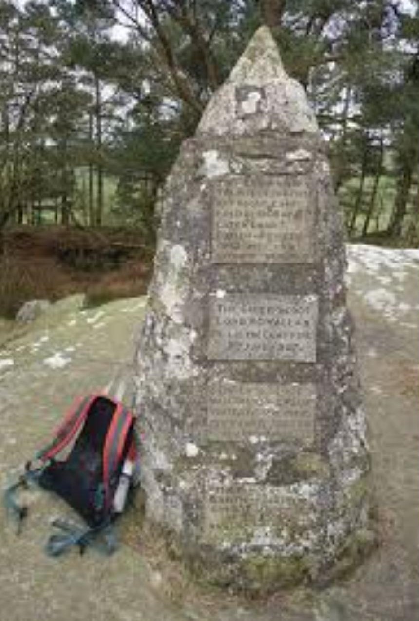
Not far into the wood we left the path briefly to admire (in some cases) the cairn erected to the first Boy Scout camp.


Baden Powell held the first camp for boys on Brownsea Island in 1907 but the first official Boy Scouts camp was held in Northumberland near Humshaugh in August/September 1908. Three of us had been scouts so were pleased to admire the cairn, the others were indifferent.

Back on the very muddy path through the wood and across a field we got some foot relief on reaching a road. Turning left, then almost immediately right  across more soggy field and wood we reached the road near Walwick Hall. The road is the so called Military Road and at this point is built on the Roman Wall itself.

Some where near the hall, in 1826 a man named Joseph Hedley, a quilter by trade and 76 years old was brutally murdered by a person or persons unknown. His fame as a quilter was well known, his work was to be found around the world. His cottage has been rebuilt at Beamish, home of the great Museum of Northern Life.


This is not Walwick Hall, I just liked the building.

Turning rat the junction beyond the hall we followed the B6319 to Walwick Grange. A stile here pointed the way into some soggy fields but fortunately a low row of large stones provided us with a Herbie Spot.(Skinny whips, cookies, a lovely muesli biscuit and savoury bun from Mrs A)

We walked the very muddy edge of a ploughed field (mile 5) to Park Shield, turned left , turned left again (mile 6)  then went down a track to a large electricity sub station.

You don't expect a substation on a country walk. There is a path round it.
Once round the substation we took a footpath across the Stanegate (Roman Road south of and usually parallel to the Wall). Joining a grassy track we reached the village of Fourstones, walked the road for a while and then turned left down towards the River Tyne, crossing the Newcastle to Carlisle Railway.


             Railway crossing, sadly we didn't have to phone as the route was clear. There is a pub nearby, The Railway, but it seemed to have been closed for some time.

The footpath on the bank of the river was not exactly mud free but it was easy walking.

                                       River  Tyne (South)


           There were a number of painted stones nestling at the foot of several trees. No explanation but very pretty.

After about half a mile the path went under the railway and took us through the last bit of mud back to Newbrough. Changed we went to the Fox and Hounds in Wylam, TTL and zero alcohol Guinness.

Contains OS data, copyright. Crown copyright and database right 2023

Just over 9 miles, muddy with a few climbs but nothing too strenuous.

                             Newbrough Town Hall

                            A proper stile


Saturday 11 November 2023

Another Newton

 Another Newton and a castle. November 10th

Including prefixes and suffixes there is a large number of Newtons in England, and more in the rest of the UK. This new village is just off the A69 in Northumberland. Head west and turn north at the sign. There is free parking by the community centre.

OS OL43 Hadrian's Wall covers the walk.

On the way we stopped for breakfast at Brockbushes Farm Shop. It was packed, there was a Christmas Fair on and visitors needed tickets. We went straight to Newton and went to the Duke of Wellington pub for tea or coffee, no bacon butties. The young man serving said we could leave our cars in the yard as we promised to call in after the walk for drinks.


                       parking behind the Duke of Wellington pub in Newton.

Lovely sunny morning, booted and lightly suited we set off. Walking through the village on the road heading north east we passed the entrance to Mowden School and the church at Newton Hall. After a half mile we turned north into the first fields of the day and headed  towards Heathery Edge.


The church at Newton Hall, dedicated to St. James and built in 1857.

Round the Heathery Edge farm buildings and onwards, following muddy tracks on field edges until we reached the farm at Shildonhill. Turning left on a narrow road, at mile 2 turned right and followed another minor road until we met  and crossed the B6321. Still on a road we walked to the B6318, usually known as the Military Road and buiolt on top of Hadrian's Wall. Here we joined the Hadrian Wall Path, also in this area known as St. Oswald's Way. He gets around, St Oswald. 

The footpath here is alongside the road and it is fairly busy but just beyond mile 4 we crossed over, went into the field and spotted three very large stones that made a Herbie Spot.

                          We don't see many of these.
              The vallum close to our Herbie Spot. (Skinny whips, savoury and sweet from Mrs A)
The vallum was a defensive earthwork south of the wall. Pretty clear at this point.
Lunch over we headed across the watery fields to Halton, home of an impressive house with what looks like a peel tower, and some equally impressive hedges.

                         Halton
Back on tarmac we headed south to Aydon Castle hoping for tea but it had closed for the winter.

Aydon Castle. Originally a manor house built in the 13th century, fortified to keep out the Scots later.
Leaving the castle we followed tracks to the village of Aydon, joined  the B6321heading north east before getting back into fields at mile 7.
From this point the footpath is quite well marked and follows field edges again before crossing the Brockhole Burn.


                   Well maintained footbridge on Brockhole Burn.
Continuing uphill and walking through a small wood (mile 9) we were soon back at Newton. And having removed muddy boots we went to the Duke of Wellington, fine pub and restaurant, serving Timothy Taylor's Landlord.

Contains OS data, copyright. Crown copyright and database right 2023
The walk is about 9.5 miles, some on roads but easy going with a couple of short climbs.