Женныъс Лантерн
Jenny's Lantern November 24
In 1959 the Everly Brothers had a hit with a song called "Poor Jenny" written by Boudleaux and Felice Bryant. Not one of their greatest hits in the UK, it was the tale of a teenage couple going to a party which ended in "a heck of a fight". Poor Jenny got arrested for being a teenage gang leader and was jailed. Her family, not surprisingly, were hot on the trail of her boyfriend. Great stuff, a ballad of teenage angst, no an operetta. I still think their best song is "Always Drive a Cadillac."
The Jenny of the title of this weeks blog was a far more sensible woman. Legend has it that Jenny stood on top of a hill at night with a lantern, guiding her husband home from his drinking session in an Eglingham tavern. The hill now bears the name "Jenny's Lantern." Sounds like the sort of wife we gadgies need. An alternative explanation for the name of the hill is that "Jenny's Lantern" is a local name for will o' the wisp, the phospheresccent light seen on marshy ground.
There are seven gadgies out today, (A heptagadge) last week's crew has been joined by Cornish Johhny, friend of Dave, registered gadgie and keen, knowledgable musician. Proper music that is, Jazz, sixties pop and so on. Henceforth to be known as musicmeister.
Today's walk starts in Eglingham, a pretty linear village in Northumberland. From Newcastle take the A1 to Alnwick, go through the town and shortly after the castle take the B6346 to Eglingham. There is some parking on the lane down to the village church which is dedicated to St. Maurice,* patron saint of English dancers. It was built in the 12th and 13th centuries, like much of this part of the country was sacked by the Scots, and rebuilt in the 17th century. At the right time of year you can buy home made preserves in the church, an honesty box is provided. Down the village street you can also buy farm vegetables from an open stall, honesty box also provided. Sainsbury's, Morrisons etc. please note! Use OS81. The church is at GR106195.
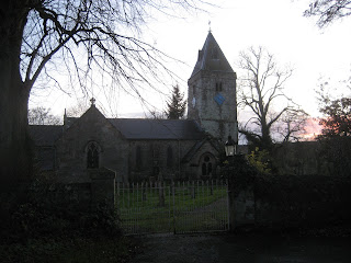
St. Maurice's church Eglingham.
From the church walk past the village inn, The Tankerville Arms, a lovely friendly pub and restaurant, past the farm vegetable stall until you come to a signpost on the righthand side of the road. Go through the gates, carefully closing them behind you of course, and follow the path on the south side of the Eglingham burn through several fields. Keep Kimmer Lough on your right hand side. On our walk the lough was home to a large flock of geese which took off, circled in a magnificent skein and landed back on the water, becoming a flock again. Dave thought they were Greylags but was not too sure.
Once across the Titlington Burn turn right and follow the path uphill, turning off to the left to climb to the top of the hill called Jenny's Lantern. On the top is the ruin of a building described as an eyecatcher, a type of folly, possibly built round a shepherd's cottage. It makes a good Herbiespot.

 Although we were not welcomed by a lantern waving wife, nor by Harry's mythical Scandinavian Air Stewardesses, Jenny's Lantern made a welcome Herbiespot, especially as a short sharp squall arrived, forcing us to don waterproofs. I think that's my glove on the left. Forget the blue sky, it rained. Of course I brought pies. I am the pieman.
From Jenny's Lantern the walk continues almost due west to an L shaped plantation. Between the Lantern and the plantation is a small tarn, there were many small ducks on it, either wigeon or teal. In the crook of the L is stone cairn. at this point turn north west downhill. But take care, do not cross Titlington Burn and walk up the side of the field towards Titlington Mount or you will be hunted down by an irate farmer on a quad bike and ASBOed. Instead turn left down a tree lined farm track south of the burn. Just before Titlington nip across a field which is not a right of way but joins one at the next fence. When this path reaches a road turn left and almost immediately turn right through Titlington Woods. Once through the wood follow a rough path westwards to the Trig Point* *on Titlington Pike.
 Shepherd's Law, Hermitage of St. Mary and St. Cuthbert. The chapel is on the right.
From here you can see Shepherd's Law, an 18th century farm which since 1971 has been slowly rebuilt as the Hermitage of St. Mary and St. Cuthbert. An ecumenical retreat with a beautiful modern chapel completed in 2004.***
Take the path above Shepherd's Law towards Beanley Plantation. Once inside the woods turn left at the first forest trail and then turn right almost immediately. This uphill track is very muddy, the ground having been churned up by a large John Deere machine with half a dozen deeply treaded tyres. The machine strips the conifers of their branches and cuts the tree down. No tartan shirted "I'm a lumberjack and I'm OK" chaps round here!
When you emerge from the wood onto a road climb the bank on the right and cross the fields to have a look at "The Ringses"****. Nothing to do with Tolkein, the Ringses are the remains of a 2000 year old fort and settlement. Dave likes them!
Turn south and walk to a track, turn left and after about half a mile turn left on to a badly signed path that leads over fields and back to Eglingham
My pedometers worked well today, giving readings of 10.61 and 10.08 miles. Dave had trouble, one pedometer working in kilometres, neither being too close to mine. The Benometer said 10.7 miles, measuring on a map gave just under 10. The walk is easy, little climbing, but at this time of the year it is muddy.
We finished the walk about 4pm. The Tankerville Arms was closed until 6, winter hours I suppose, which was a shame so we were forced by circumstances to retire to the Anglers Arms a Weldon Bridge to check the quality of the Timothy Taylors Ale. It was excellent as usual, we sat round a real fire and discussed how, as children, it had been our job to bring the coal in, some of us had had the old style ranges which were fires and ovens alongside. Today we all have central heating, and much better it is too. The beer and crack were so good Brian suggested we stay the night, nice idea, should do it sometime, then the drivers can drink too!
* Not really, before you tell me it's spelled "Morris". He was a leader of the 3rd century Roman Theban Legion and patron saint of soldiers, swordsmiths, armies and infantry.
* *Trig point. Before satellites the UK was mapped with incredible accuracy by the Ordnance Survey. Trig points, truncated square pyramids, were erected on hundreds of high points and used in mapping. George Everest did a similar triangulation mapping of India, hence the name of the mountain.
*** It has a web site with history, pictures etc. www.shepherdslaw.org
****The Ringses, a multivallate hillfort, deep defensive walls and several settlements around it. Not covered inthe Hillforts book mentioned elsewhere, presumably because they are outside the national park. Shame.
привет русcкий читатели!
And finally, the College of Arms has been pleased to award me a coat of arms. I had it designed by a young cartoonist and writer of a soon to be published children's book. It is a pie couchant with crossed quills. My motto is borrowed from a walking society that is hibernating, The Wobbly Bellies. In case your Latin is not up to scratch it means "Seldom Passed but often inebriated" It was translated from English by my daughter, so blame her if it is incorrect.

see www.helenhancocks.com
www.cakepoppins.co.uk
Lord Blogpiemikester
Jenny's Lantern November 24
In 1959 the Everly Brothers had a hit with a song called "Poor Jenny" written by Boudleaux and Felice Bryant. Not one of their greatest hits in the UK, it was the tale of a teenage couple going to a party which ended in "a heck of a fight". Poor Jenny got arrested for being a teenage gang leader and was jailed. Her family, not surprisingly, were hot on the trail of her boyfriend. Great stuff, a ballad of teenage angst, no an operetta. I still think their best song is "Always Drive a Cadillac."
The Jenny of the title of this weeks blog was a far more sensible woman. Legend has it that Jenny stood on top of a hill at night with a lantern, guiding her husband home from his drinking session in an Eglingham tavern. The hill now bears the name "Jenny's Lantern." Sounds like the sort of wife we gadgies need. An alternative explanation for the name of the hill is that "Jenny's Lantern" is a local name for will o' the wisp, the phospheresccent light seen on marshy ground.
There are seven gadgies out today, (A heptagadge) last week's crew has been joined by Cornish Johhny, friend of Dave, registered gadgie and keen, knowledgable musician. Proper music that is, Jazz, sixties pop and so on. Henceforth to be known as musicmeister.
Today's walk starts in Eglingham, a pretty linear village in Northumberland. From Newcastle take the A1 to Alnwick, go through the town and shortly after the castle take the B6346 to Eglingham. There is some parking on the lane down to the village church which is dedicated to St. Maurice,* patron saint of English dancers. It was built in the 12th and 13th centuries, like much of this part of the country was sacked by the Scots, and rebuilt in the 17th century. At the right time of year you can buy home made preserves in the church, an honesty box is provided. Down the village street you can also buy farm vegetables from an open stall, honesty box also provided. Sainsbury's, Morrisons etc. please note! Use OS81. The church is at GR106195.

St. Maurice's church Eglingham.
From the church walk past the village inn, The Tankerville Arms, a lovely friendly pub and restaurant, past the farm vegetable stall until you come to a signpost on the righthand side of the road. Go through the gates, carefully closing them behind you of course, and follow the path on the south side of the Eglingham burn through several fields. Keep Kimmer Lough on your right hand side. On our walk the lough was home to a large flock of geese which took off, circled in a magnificent skein and landed back on the water, becoming a flock again. Dave thought they were Greylags but was not too sure.
Once across the Titlington Burn turn right and follow the path uphill, turning off to the left to climb to the top of the hill called Jenny's Lantern. On the top is the ruin of a building described as an eyecatcher, a type of folly, possibly built round a shepherd's cottage. It makes a good Herbiespot.


From Jenny's Lantern the walk continues almost due west to an L shaped plantation. Between the Lantern and the plantation is a small tarn, there were many small ducks on it, either wigeon or teal. In the crook of the L is stone cairn. at this point turn north west downhill. But take care, do not cross Titlington Burn and walk up the side of the field towards Titlington Mount or you will be hunted down by an irate farmer on a quad bike and ASBOed. Instead turn left down a tree lined farm track south of the burn. Just before Titlington nip across a field which is not a right of way but joins one at the next fence. When this path reaches a road turn left and almost immediately turn right through Titlington Woods. Once through the wood follow a rough path westwards to the Trig Point* *on Titlington Pike.

From here you can see Shepherd's Law, an 18th century farm which since 1971 has been slowly rebuilt as the Hermitage of St. Mary and St. Cuthbert. An ecumenical retreat with a beautiful modern chapel completed in 2004.***
Take the path above Shepherd's Law towards Beanley Plantation. Once inside the woods turn left at the first forest trail and then turn right almost immediately. This uphill track is very muddy, the ground having been churned up by a large John Deere machine with half a dozen deeply treaded tyres. The machine strips the conifers of their branches and cuts the tree down. No tartan shirted "I'm a lumberjack and I'm OK" chaps round here!
When you emerge from the wood onto a road climb the bank on the right and cross the fields to have a look at "The Ringses"****. Nothing to do with Tolkein, the Ringses are the remains of a 2000 year old fort and settlement. Dave likes them!
Turn south and walk to a track, turn left and after about half a mile turn left on to a badly signed path that leads over fields and back to Eglingham
My pedometers worked well today, giving readings of 10.61 and 10.08 miles. Dave had trouble, one pedometer working in kilometres, neither being too close to mine. The Benometer said 10.7 miles, measuring on a map gave just under 10. The walk is easy, little climbing, but at this time of the year it is muddy.
We finished the walk about 4pm. The Tankerville Arms was closed until 6, winter hours I suppose, which was a shame so we were forced by circumstances to retire to the Anglers Arms a Weldon Bridge to check the quality of the Timothy Taylors Ale. It was excellent as usual, we sat round a real fire and discussed how, as children, it had been our job to bring the coal in, some of us had had the old style ranges which were fires and ovens alongside. Today we all have central heating, and much better it is too. The beer and crack were so good Brian suggested we stay the night, nice idea, should do it sometime, then the drivers can drink too!
* Not really, before you tell me it's spelled "Morris". He was a leader of the 3rd century Roman Theban Legion and patron saint of soldiers, swordsmiths, armies and infantry.
* *Trig point. Before satellites the UK was mapped with incredible accuracy by the Ordnance Survey. Trig points, truncated square pyramids, were erected on hundreds of high points and used in mapping. George Everest did a similar triangulation mapping of India, hence the name of the mountain.
*** It has a web site with history, pictures etc. www.shepherdslaw.org
****The Ringses, a multivallate hillfort, deep defensive walls and several settlements around it. Not covered inthe Hillforts book mentioned elsewhere, presumably because they are outside the national park. Shame.
привет русcкий читатели!
And finally, the College of Arms has been pleased to award me a coat of arms. I had it designed by a young cartoonist and writer of a soon to be published children's book. It is a pie couchant with crossed quills. My motto is borrowed from a walking society that is hibernating, The Wobbly Bellies. In case your Latin is not up to scratch it means "Seldom Passed but often inebriated" It was translated from English by my daughter, so blame her if it is incorrect.
see www.helenhancocks.com
www.cakepoppins.co.uk
Lord Blogpiemikester


