Taking the Mickley (Northumberland) July 24th
After a few showery days the young lady on local Tv promises a dry day at least. Six of us are having a fairly local walk from Mickley near Prudhoe in Northumberland. A country walk rather than a climb. We are, John x3, Harry, Dave and me. The walk starts from the garden centre at Mickley Square, using the car park across the road, the overflow. A69 west, turn off for Ovingham, cross the Tyne and follow signs.
Two maps for the walk: OS Explorer 316 Newcastle upon Tyne and Explorer 307 Consett and Derwent.
 An uncropped photo of a car parking area across the road from the garden centre at Mickley Square. No idea whether or not it is an official park but it is free and therefore a good thing.
The walk:
We left the parking area and turned left. Within yards the leader found the sign post for the walk and we set off uphill across several fields until we reached East farm, turned right and walked through the hamlet of High Mickley.
Once through the houses most of us turned left on to the track marked Ward Lane but John L. realised that he had left his phone somewhere and went back to find it. Harry nobly went with him. The phone had been retrieved by a dog and was then retrieved by the dog's owner. John retrieved his phone from her. meanwhile four of us waited at the corner of the track close to the Gallop marked on the map.
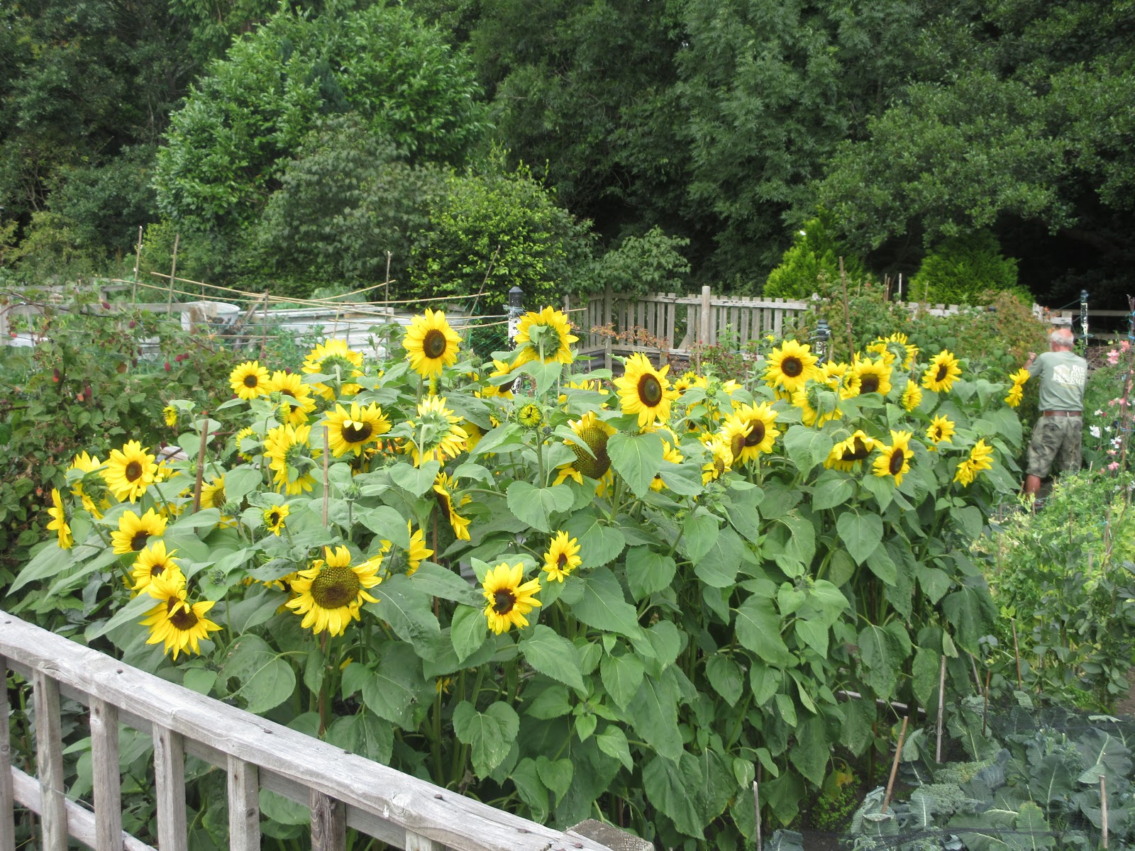
 Fields of gold
 The gallop. This is horse country, we saw more horses than people. The fence is a bit dilapidated and the track is covered with wood chips, bit like a children's playground.
 Just four of the many
We waited for some time for the other two before deciding they knew the way and we set off for Hedley on the Hill, first climbing a wall to get on the footpath we should have joined at High Mickley. The footpath went on the edges of fields, almost due south until we climbed the gentle hill to Hedley on the Hill. John had found his phone and rang to say they were on their way so we agreed to wait outside the village pub, and have a mini Herbie.
 The Feathers pub., Hedley on the Hill
 Horse country. Hitching posts outside the pub.
Once we were altogether again we resumed the walk. The footpath is posted, it goes between two houses in the village and then across fields to Hedley Grange Farm. There is a fenced path round the farm but the stile to get into it, stuck in the corner of a field and overgrown with nettles and brambles was not too easy to find, but we did.
A few fields later we were at West Riding Wood. Turning west we followed a footpath through the trees, emerging at last into a field. Turning North Westish we climbed through woodland to the farm at Apperley, joined a track and walked past Stocksfield Golf Course to the road at New Ridley.
Sitting on a wall on the side of the road is not an ideal Herbie Spot but it was the chosen one, partly perhaps for the view of Hindley Hall. We had the usual offerings, Skinny Whips, my current favourite, biscuits, more biscuits and caramel bars.
 Hindley Hall. Built for a local family in the 19th century it became a special school from 1952 to 1991. It was then converted into a number of houses and apartments, or flats if you prefer.
Herbie time over we walked a short distance up the road passing the pub Dr Syntax.
 Dr Syntax. named for a horse as the sign suggests.
Almost opposite the pub is a footpath and we took it, heading downhill across fields to Bat House Road.

 Two visitors from Scotland.
The footpath goes round Park Estate and the remains of Ridley Mill before following the Stocksfield Burn down to the village of that name.
 The old mill by the stream


 Large pond. The geese are on the far side.


After a few showery days the young lady on local Tv promises a dry day at least. Six of us are having a fairly local walk from Mickley near Prudhoe in Northumberland. A country walk rather than a climb. We are, John x3, Harry, Dave and me. The walk starts from the garden centre at Mickley Square, using the car park across the road, the overflow. A69 west, turn off for Ovingham, cross the Tyne and follow signs.
Two maps for the walk: OS Explorer 316 Newcastle upon Tyne and Explorer 307 Consett and Derwent.

The walk:
We left the parking area and turned left. Within yards the leader found the sign post for the walk and we set off uphill across several fields until we reached East farm, turned right and walked through the hamlet of High Mickley.
Once through the houses most of us turned left on to the track marked Ward Lane but John L. realised that he had left his phone somewhere and went back to find it. Harry nobly went with him. The phone had been retrieved by a dog and was then retrieved by the dog's owner. John retrieved his phone from her. meanwhile four of us waited at the corner of the track close to the Gallop marked on the map.


We waited for some time for the other two before deciding they knew the way and we set off for Hedley on the Hill, first climbing a wall to get on the footpath we should have joined at High Mickley. The footpath went on the edges of fields, almost due south until we climbed the gentle hill to Hedley on the Hill. John had found his phone and rang to say they were on their way so we agreed to wait outside the village pub, and have a mini Herbie.


Once we were altogether again we resumed the walk. The footpath is posted, it goes between two houses in the village and then across fields to Hedley Grange Farm. There is a fenced path round the farm but the stile to get into it, stuck in the corner of a field and overgrown with nettles and brambles was not too easy to find, but we did.
A few fields later we were at West Riding Wood. Turning west we followed a footpath through the trees, emerging at last into a field. Turning North Westish we climbed through woodland to the farm at Apperley, joined a track and walked past Stocksfield Golf Course to the road at New Ridley.
Sitting on a wall on the side of the road is not an ideal Herbie Spot but it was the chosen one, partly perhaps for the view of Hindley Hall. We had the usual offerings, Skinny Whips, my current favourite, biscuits, more biscuits and caramel bars.

Herbie time over we walked a short distance up the road passing the pub Dr Syntax.

Almost opposite the pub is a footpath and we took it, heading downhill across fields to Bat House Road.


The footpath goes round Park Estate and the remains of Ridley Mill before following the Stocksfield Burn down to the village of that name.


And some local art work
WE walked on the road from the railway station, past the sports fields and down a track, passing a large pond with a flock of Canada Geese, under the railway and down to the footpath alongside the Tyne.


River Tyne
We crossed the railway, obeying instructions to l;ook both ways and only cross if the light was green and walked up the track towards Eltringham. Originally heading east the track turns on itself and climbs towards the road. In order to take a short cut we scrambled up a steep, pathless bank with a few saplings and a bed of leg catching brambles. Unfortunately the sapling I grabbed to help up the last yard or so snapped. According to John Lockey I fell backwards in slow motion, landed in the brambles on my right shoulder and cracked the back of my head against a tree. Being from Yorkshire there's not much in my head and I think I have survived with a sore head, scratches from the brambles and a bruised shoulder.
Minutes after I hauled myself up we were at the car park> Changed, some went to the pub, I went home, accompanied by Dave in case I passed out.

Contains OS data, copyright. Crown copyright and database right 2020
Matrix for the day
steps miles
NAK 29429 10,68
Dave's NAK 1 22498 10.29
"""""""""""""2 22551 10.32
""""""""""""SM 22602 10.35
OUTDOOR 10.25
Garmin 10.64
And a few pictures: