The day that the rains came down... April 29th.
(Northumberland)
The weather recently has been most unspring like and for the gadgies' day out we have been promised rain, snow, hail and cold winds straight from the Arctic. As a result the planned route across fields and through woodland has been changed to a walk along narrow but metalled country roads in the Hadrian's Wall area. Six of us out, me, Harry, Dave, Ben, Brian and only one John (H) we met, in the rain, at the Brockbushes garden centre/farm shop/pick your own (in season of course)/ teashop. It is west of Newcastle on the A69 at the Corbridge roundabout. It was busy, the grey pound holders were out in force and they weren't picking strawberries. Some of us had bacon sandwiches, some toasted teacakes or scones, with coffee or tea. A five flitch sandwich, I thought, partly because of their rarity in my diet.
Breakfast over we returned along the A69 for a short distance to the roundabout and took the exit for Newton, a small village overlooking the Tyne Valley. There is a car park attached to the village hall, visitors are welcome to use it.
 One of the delights of Brockbushes, an ancient Fergie tractor
 This week's team and car park in Newton
The walk; a map is useful and, as with many days out it is covered by two, mostly OS316 Newcastle upon Tyne, and a tiny bit on OS OL 43 Hadrian's Wall. The car park is at GR NZ 036646 approx.
Dressed appropriately, although at the start the rain had ceased, we set off. Leaving the car park we headed up the lane heading north west which turns through about 90 degrees and then , at Newton Hall, we took the road heading west of north past heathery Edge, which appears to specialise in horses. It's a very straight road, possibly Roman, they spent a lot of time here.
 Dexter, sinister, dexter sinister, dexter sinister an old joke from my Latin book at school.
At the end of the road we turned right and then almost immediately on another straight bstretch of lane that brought us to the B6318, known as the Military Road, that runs alongside or on top of in places, Hadrian's Wall. We turned west and followed the Hadrian Wall Path, long distance trail across England following the route of Hadrian's masterpiece. The ditch dug to the south of the wall complex, the Vallum, is clearly visible in places.
 Vallum, complete with chariot tracks.
For part of the way the path crosses fields, there are plenty of stiles to cross. At Onnvm Roman Fort, (site of, not much to see), we turned south through an impressive gateway to Halton.
 Impressive gateway to Halton.
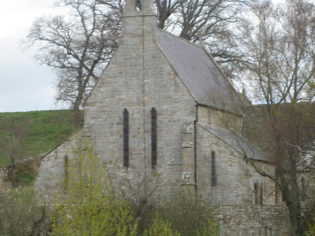
At Halton farm there is an impressive tower, dating back to the 14th century and, not surprisingly, built from Roman stones. There is also a beautiful chapel dating back to Norman times and probably also containing recycled Roman stones.
 Halton church
 and Halton Tower.
In the field beyond the buildings was a small herd of black sheep, a whole family of them in fact, possibly looking for the white sheep of the family.

 Black sheep, one with a coat too.
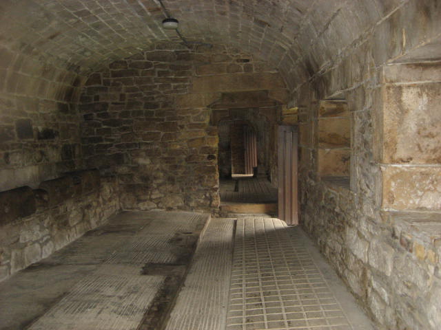
By now it had started to rain as we followed the lane down to Aydon Castle.


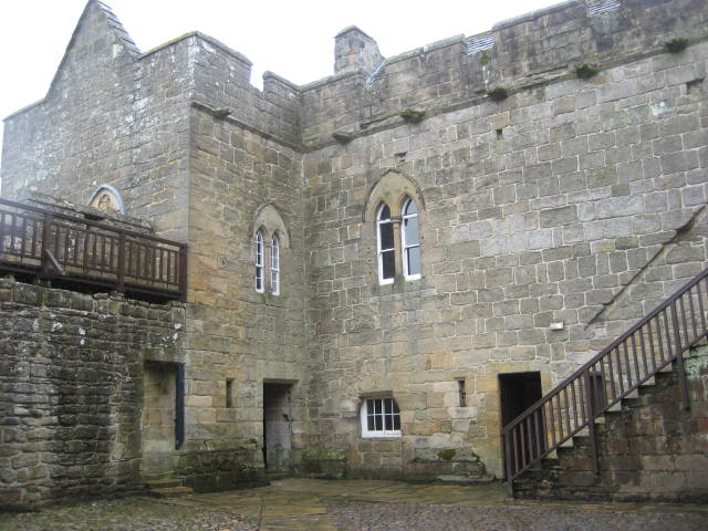
 Aydon Castle, run by English Heritage, free to members, £4.10 to gadgies.
The castle dates back to the 14th century and is really a fortified manor house. Next to the English Heritage office and gift shop are several sheds. We made use of one to have a Herbie Spot out of the sleet.
Mrs. A had donated savoury tarts again and we shared Brunch bars, ginger biscuits, chocolate caramel and almond rocca from www.cakepoppins.co.uk. (In return for feeding cats.)
As we ate a small group of average sized students with extremely large packs came into the castle courtyard, accompanied by two teachers or instructors. They were on their Duke of Edinburgh journey. Last night they had pitched their tents in the snow, the temperature dropped below freezing so they had retired to a scout hut, and who can blame them.
Leaving the castle we headed down the Cor Burn before realising our mistake, retraced our steps to the ancient building we had just left and took the lane heading roughly east, following it until it met the B6321, turned right then left and followed the lane until we spotted the rather old road sign:
 A real road sign
 Cor Burn, a mistake, but pretty, lots of garlic.
At the sign post we turned south east and followed the same straight road we had started on back to Newton.
Changed we went to the village pub, The Duke of Wellington, named for the inventor of rubber boots and beef pies. A pub restaurant hotel, we were made very welcome and offered a choice of Tyneside Blonde, Shuggy Boat, Old Speckled Hen, Duke of Wellington's special or coffee.
After an hour discussing trivial matters such as the EU referendum and serious matters like why is it always celebrities who make TV shows like "Celebrity Coastal Walks with dogs" or "Celebrity Visits to very small railway stations". (Both currently on TV, honest) Why not a bunch of gadgies wander aimlessly round the Cheviots on a Friday?
Never mind, in spite of the weather it was a good day out, enjoyed by all.
The Matrix MMXVI O
steps miles
LIDL3D 21904 9.8
NAK 26652 10.06
Dave's LIDL3D 21792 10.22
" USB 21399 10.46
"NAK 21289 10,41
OUTDOOR GPS 9.97
etrex GPS 10.65
Brian 10.05
Walking Time 3 hours 26 minutes. Standing around time 55 minutes

(Northumberland)
The weather recently has been most unspring like and for the gadgies' day out we have been promised rain, snow, hail and cold winds straight from the Arctic. As a result the planned route across fields and through woodland has been changed to a walk along narrow but metalled country roads in the Hadrian's Wall area. Six of us out, me, Harry, Dave, Ben, Brian and only one John (H) we met, in the rain, at the Brockbushes garden centre/farm shop/pick your own (in season of course)/ teashop. It is west of Newcastle on the A69 at the Corbridge roundabout. It was busy, the grey pound holders were out in force and they weren't picking strawberries. Some of us had bacon sandwiches, some toasted teacakes or scones, with coffee or tea. A five flitch sandwich, I thought, partly because of their rarity in my diet.
Breakfast over we returned along the A69 for a short distance to the roundabout and took the exit for Newton, a small village overlooking the Tyne Valley. There is a car park attached to the village hall, visitors are welcome to use it.


The walk; a map is useful and, as with many days out it is covered by two, mostly OS316 Newcastle upon Tyne, and a tiny bit on OS OL 43 Hadrian's Wall. The car park is at GR NZ 036646 approx.
Dressed appropriately, although at the start the rain had ceased, we set off. Leaving the car park we headed up the lane heading north west which turns through about 90 degrees and then , at Newton Hall, we took the road heading west of north past heathery Edge, which appears to specialise in horses. It's a very straight road, possibly Roman, they spent a lot of time here.

At the end of the road we turned right and then almost immediately on another straight bstretch of lane that brought us to the B6318, known as the Military Road, that runs alongside or on top of in places, Hadrian's Wall. We turned west and followed the Hadrian Wall Path, long distance trail across England following the route of Hadrian's masterpiece. The ditch dug to the south of the wall complex, the Vallum, is clearly visible in places.

For part of the way the path crosses fields, there are plenty of stiles to cross. At Onnvm Roman Fort, (site of, not much to see), we turned south through an impressive gateway to Halton.

At Halton farm there is an impressive tower, dating back to the 14th century and, not surprisingly, built from Roman stones. There is also a beautiful chapel dating back to Norman times and probably also containing recycled Roman stones.


In the field beyond the buildings was a small herd of black sheep, a whole family of them in fact, possibly looking for the white sheep of the family.


By now it had started to rain as we followed the lane down to Aydon Castle.


The castle dates back to the 14th century and is really a fortified manor house. Next to the English Heritage office and gift shop are several sheds. We made use of one to have a Herbie Spot out of the sleet.
Mrs. A had donated savoury tarts again and we shared Brunch bars, ginger biscuits, chocolate caramel and almond rocca from www.cakepoppins.co.uk. (In return for feeding cats.)
As we ate a small group of average sized students with extremely large packs came into the castle courtyard, accompanied by two teachers or instructors. They were on their Duke of Edinburgh journey. Last night they had pitched their tents in the snow, the temperature dropped below freezing so they had retired to a scout hut, and who can blame them.
Leaving the castle we headed down the Cor Burn before realising our mistake, retraced our steps to the ancient building we had just left and took the lane heading roughly east, following it until it met the B6321, turned right then left and followed the lane until we spotted the rather old road sign:


At the sign post we turned south east and followed the same straight road we had started on back to Newton.
Changed we went to the village pub, The Duke of Wellington, named for the inventor of rubber boots and beef pies. A pub restaurant hotel, we were made very welcome and offered a choice of Tyneside Blonde, Shuggy Boat, Old Speckled Hen, Duke of Wellington's special or coffee.
After an hour discussing trivial matters such as the EU referendum and serious matters like why is it always celebrities who make TV shows like "Celebrity Coastal Walks with dogs" or "Celebrity Visits to very small railway stations". (Both currently on TV, honest) Why not a bunch of gadgies wander aimlessly round the Cheviots on a Friday?
Never mind, in spite of the weather it was a good day out, enjoyed by all.
The Matrix MMXVI O
steps miles
LIDL3D 21904 9.8
NAK 26652 10.06
Dave's LIDL3D 21792 10.22
" USB 21399 10.46
"NAK 21289 10,41
OUTDOOR GPS 9.97
etrex GPS 10.65
Brian 10.05
Walking Time 3 hours 26 minutes. Standing around time 55 minutes