Translate

Saturday 31 July 2021

A wet walk from Warkworth. (Northumberland) 

July 30th

Hej Sverige.  So far this month there have been 1780 hits on the gadgie blog from Sweden, so Hello Sweden, thanks.

The forecast for the day was a few light showers. The walk for the day was planned as a rerun of a favourite seaside walk from Warkworth in Northumberland.  A pretty village  dominated by a ruined castle Warkworth is found by driving up the A189. Drive down the hill, enter the square on the left, drive past the church and there is a car park/picnic area overlooking the River Coquet. Free too and the picnic benches are helpful for booting up.

It is possible to do this easy walk without a map but it is covered by OS Explorer 332 Alnwick and Amble.

Car park. In fact prettier than the picture as it is next to the river.
Once the four of us were ready (Dave, Harry, John H. and me) we set off down the riverside path past the church.


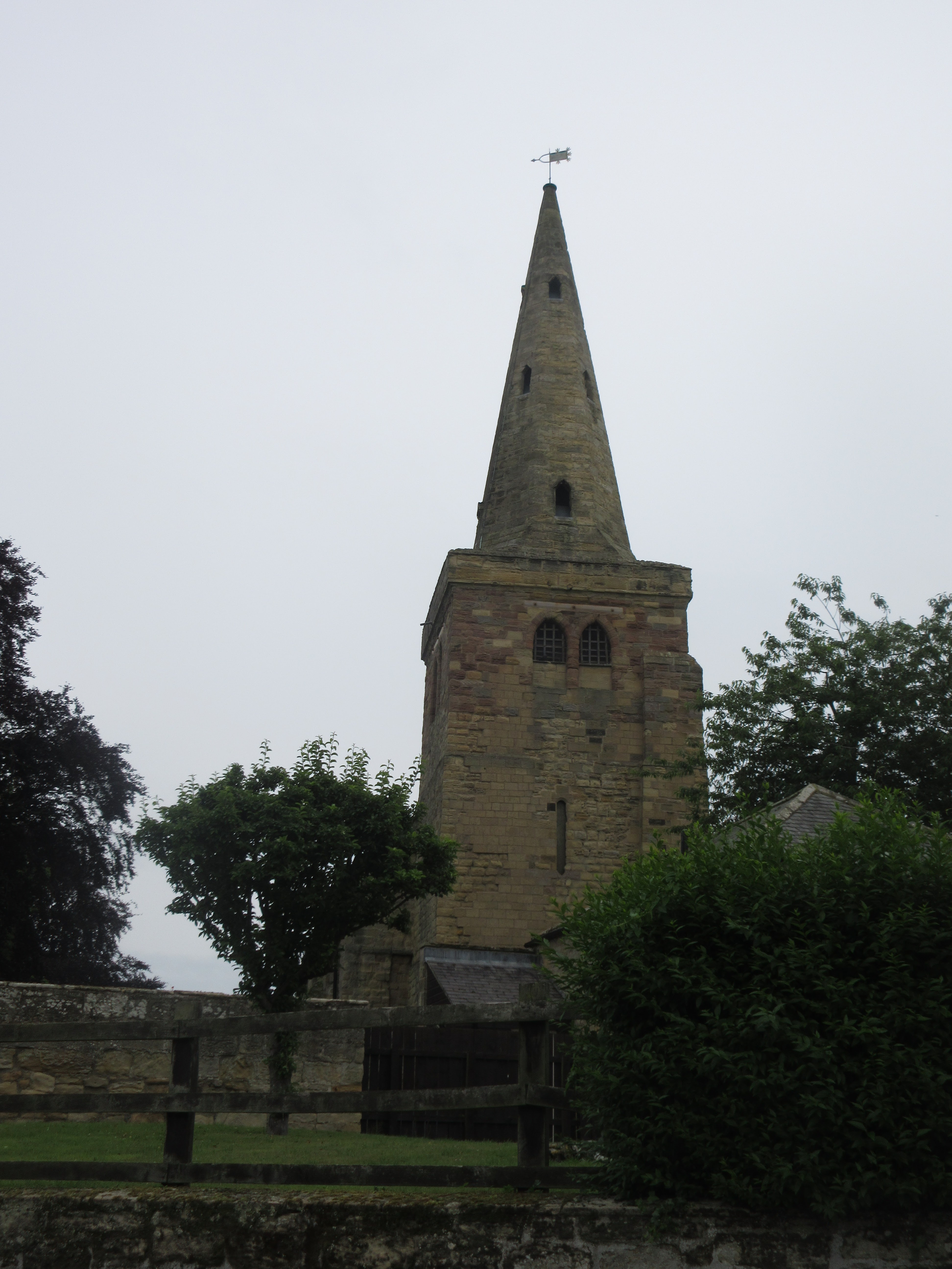
St Lawrence's church. An almost completely Norman church with later additions like the tower. Dave, archaeologist thinks it might have Saxon origins.
We followed the footpath to the old bridge which is protected by an equally old gate.


The old bridge, pedestrians only. The road bed is made of stone setts.  (Technical note: setts are rectangular, cobbles are large pebbles) The gate is vertical really.
Over the bridge we crossed the road and headed for the beach, leaving the road to follow a footpath through fields. Much nicer than walking the tarmac. The route passes two more car parks, with toilets, before heading down to the dunes. rather than go straight to the beach we turned right and followed the footpath on the north side of the Coquet towards the jetty.


                         Amble from across the Coquet.
At the jetty we walked through the gap in the dunes and headed north on the beach. The harder sand is near the water's edge. Considering it was overcast there were still a lot of families doing traditional sea side things. Building sand castles, playing with a frisbee, walking their dogs, sending them into the sea. A few surf board riders too.
The only tricky bit are the rocks at Birling Carrs and they can be avoided by climbing up to the caravan park. We crossed the Carrs and continued on the beach until we were opposite Alnmouth. 

                      Alnmouth. Pretty village usually recommended in the Times as a good place to visit in Northumberland.
Here we climbed the small hill with a cross on top that marks the area where the original village church of St Waleric stood. (12th C) Cut off and demolished by the great storm of 1806 which also changed the course of the river, nothing remains. 
Down the slope from the hill are the ruins of what looks like a Norman chapel but is a mortuary chapel built in 1870.
At this point the rain started. The chapel is our usual Herbie Spot so we took what little shelter we could in the building, open to the sky, and shared Titans, almond slices and Snickers and damp sandwiches although I have taken to carrying Ginsters Vegan spicy  vegetable slices not on moral grounds, I like them.

                       The chapel, an open air Herbie.
The rain was getting heavier so we didn't hang about, packed sandwich boxes away and headed for the Northumberland Coast Path/St Oswald's Way. This path goes through the dunes, passing the Alnmouth Guano shed which stood on the river bank before 1806 and is now a ruin in a field. It was used to store guano, used as fertilizer and was built away from the village because of the smell!

                                The Alnmouth guano shed.
By now it was raining heavily, I wrapped the camera and put it in my rucksack so no more pictures.
The path goes through the caravan park and then alongside Warkworth golf course. At one point it dips below a footbridge built to take golfers from one green to the next . The path then follows the edge of the course back to the track down from the village. Back across the bridge and to the cars. We were, as my mother would have said "Wet through to our knickers." We dried off as best we could, for once I had a spare shirt but not spare trousers. Too wet to go to the pub we went home. Earliest finish for many a year.
Contains OS data, copyright. Crown copyright and database right 2021.

Warkworth Castle


Saturday 24 July 2021

 A walk in Weardale from Westgate to Cowshill and back. (Durham) July 23rd.

  There are six of us out today, walking in Weardale for the first time for a long time because of........

Brian, Margaret, Harry and John H in one car; Dave and I in another. The walk starts from Westgate, a village in Weardale; A69 west, A68 south, minor road through Edmondbyers to Stanhope, turn right and a few miles later turn left at the Westgate pub, The hare and Hounds, cross the bridge and on the left is a car park, community hall and playground. Park for free too, a bonus.

The walk is covered by OS OL 31 North Pennines, useful too.

Westgate is so called as it marked the western boundary of the Bishop of Durham's hunting park. There is an Eastgate too. Hard life being the Prince Bishop of Durham.


                 Car park and view at Westgate. Prize winning parking area.

We left the car park, lightly dressed as it was yet another hot English summer day, but all carrying extra water as sensible gadgies do, and went back across the bridge to the village street, crossed the road and headed up the hill past the old school. Turning left we joined the path through the remains of the the old Slitt lead mine. 

                 Apparently built to deivert the stream and give a larger working area.


Lots of piles of stones to admire, including the remains of the water wheel pit, engine bed and others.

beyond the mine the footpath followed the Middlehope Burn, climbing slowly, then across fields before turning sharp left onto a rough track. At the junction with Seeingsike Road (a track) we walked on a deeply rutted track which also had some deep puddles until we reached the ruins of Middlehope Old Mine, which had been a source of flour- spar.  

                           Not drumlins but waste heaps

                            Another deserted farm

From the junction we headed west and uphill too  along the road until we left the tarmac and went into the welcome shade of a woodland path.

After a short walk in the shade we were out on the moors again, crossing Rase Head (586 metres or 1922 feet in Imperial units)

Eventually we began the descent to the village of Cowshill which had once also been a lead mining area. It doesn't get a mention in Pevsner's Durham buildings  an insignificant place or an omission?

As we reached the village we spotted a couple of benches which made a fine Herbie Spot.

                              The hay has been cut and dried. 
                              Waste heaps at Cowshill


                     Herbie time. Blackcurrent and apple pies, almond slices, savoury tarts and flapjacks from Mrs A. Dave is carefully packing his stuff a way and checking nothing has been left.


                             St Thomas's church, Cowshill

After the feast we crossed the road at the Cowshill Hotel, walked past the village church (St. Thomas), turned left, crossed the bridge and found the finger post for the Weardale Way. The path, which is at times part of the Minerals Way walk too, follows the River Wear.  At the first village we came too, Wearhead,  the path crosses the river, goes through the village then recrosses the river back to the south bank.

At West Blackdene it's back to the north side, easy walking close to the water, passing the village of Ireshopeburn on the far bank, passing St. John's Chapel also on the south bank. At Huntshield Ford the Weardale Way crosses the river by bridge or stepping stones and then remains on the south bank passing close to Daddery Shield before returning to Westgate and the car park. 


                                       River Wear

Changed we decided to head for the Duke of Wellingto at Riding Mill. The four drove off. Dave told me he had left some items in a plastic bag at Cowshill so we went back for them. They were not there so he had another look in his rucksack. This will not be forgotten There they were. Later than the others we reached the Duke for a refreshing pint of soda and lime.


Contains OS data, copyright. Crown copyright and database right 2021.

The walk is 10.7 miles, some climbs but mostly easy going, certainly the second half!


Monday 19 July 2021

 The flies so  numerous they did swarm.(Northumberland) Greenleighton July 16 

A team of seven for today's walk; John x 2, Margaret, Brian, Dave, Harry and me. 

The  walk starts at the old Greenleighton Quarry, found by going through Ponteland, Belsay, to Scots Gap. Turn right in the village and after a few miles turn left to Grrenleighton. There is a gate on the car park but it is free, an added bonus.

 The walk is covered by OS OL 42 Kielder Water and Forest. And it would be useful.


                   Parking free at Greenleighton quarry.

From the car park, having booted up of course but without so much as a sniff of waterproofs in bags because of the promised forecast, sunny, all day, we went through the side gate next to the car park gate and followed a path across the field, slightly west of north. At the next gate, obedient gadgies as we are, we followed the footpath down the side of the field, turned through 90 degrees at the wood and after a hundred yards or so took the path through the trees.

This path followed the edge of the wood, on the inside, through a couple of gates, before emerging into a field. Here there were two paths, the right hand goes almost directly to the west end of Fontburn Reservoir. We took the left, a mistake. The field we crossed  was boggy, with fairly deep holes to fall into. hard to see in the long grass too. Eventually we made it to the edge of a wood, just beaten by a fox.

We found a path of sorts in the wood, followed it and eventually came to a hard forest track, part of St. Oswald's Way. he gets around.

My fellow walkers pointed out that the forest flies were numerous and had taken a particular liking to my hat:

My parents had a collection of Burl Ives records on old 78s. before I discovered the Everly Brothers and Elvis I was very fond of "Blue Tail Fly" where the nasty stinging creature caused the master's death. As the song is about a master/slave relationship and dates back to the 1840s it is probably banned now but the flies sure did swarm today. Driven to distraction I swapped the hat for a baseball cap in blue and white. Not as popular with the flies. Must be the colour.


Following the track, avoiding cyclists, we first came to a deserted farm at Redpath. We considered stopping for a Herbie but it was deserted and overgrown so we continued on our way.


            Redpath.  The house is structurally sound, surprised nobody has bought it and made into a country second home.

The next farm we came to was Fallowlees. The footpath goes directly through the yard but the occupants had put notices by the gate politely asking walkers to follow a path round the farm. We did, obedient gadgies.


As dog lovers we did not wish to offend or upset. Well, Dave did.

Just beyond the farm we settled down in a gateway which had a few spare stones of suitable size and enjoyed a Herbie in the sun. Apple pies, ginger cake, almond slices, savoury tarts and biscuits. More than enough on a hot day.

Lunch devoured we headed east across a field, entered a wood, battled throgh bracken as high as an elephant's eye until we reached the farm at Newbiggin. Crossing another field and struggling over a barbed wire fence (Sit mats make excellent cover over the nasty barbs) we headed through more bracken to the path at Fontburn.

                                               An orchid
                        Newbiggin Farm
              
                                    Path on the north side of the reservoir, goes through a nature reserve too.

We followed the footpath alongside the reservoir, passing several fishermen, until we came to the dam.

                           Fontburn Resevoir

                       Old, unused railway viaduct by the waterworks.

At the southend of the dam there is a fishermen's hut selling gear and ice cream so we sensibly called a second Herbie. (Affectionately called HS2, explanation will be given on a postcard).

Cooled we followed the footpath past the rare breeds centre, so rare it seemed almost deserted.

                             Not very rare breed of geese

               Marked on the map as Rare Breeds Centre

After as hort distance following the south side of Fontburn we went through a gate and followed a grassy path up to a trig point and then back down to the cars.

On the way home we called in at the Ridley Arms in Stannington as it had been such a hot day and we needed a hydration session. Farne Island.


Contains OS data, copyright. Crown copyright and data base right 2021

The walk is about 10 miles. easy going but boggy in places.