Our boots were made for walking........
One of these day they'll walk all over U(K)
Another week of lockdown, only local walks from home permitted so here's another virtual stroll, this time on the coast in County Durham.
The walk starts from Crimdon, south of Seaham and to get there requires the skills of the routemeister. The choices are:
If there are only a few, drive in two cars and leave one at each end of the 12 mile walk.
Drive to Seaham, take the bus to Crimdon and walk back. (Arriva 23 from Seaham)
Metro to Sunderland, bus to Seaham and bus to Crimdon.
As there is a full turnout on a warm, sunny day with a gentle cooling breeze from the south we have elected to go by car to Seaham. There is a large car park, with art work, a nearby cafe for breakfast and a short walk to the high street to catch the bus to Crimdon.
 Car park with artwork. A small fee is payable and Tonia's cafe is nearby.
A short walk behind Seaham Hall brings you to the bus stop.
 Seaham Hall in Seaham, County Durham,
We queued in an orderly fashion, as Britons do, showed our go anywhere passes to the driver and took the bus to Crimdon caravan park, start of the walk.
Off the bus we walked a short distance back on the road before turning right, going under the railway that runs parallel to the coast, and reached the Durham Coast Path which is also part of the England Coast Path. Initially we thought of walking on the beach and scrambled down to it. Thinking there could be problems or an incoming tide we changed tack and scrambled back up to the cliff tops.
 Close to the start. The Magnesium Limestone cliffs of Durham
 One of several gills or denes we walked round on the walk.
Until the 1980s/90s this area was part of the Durham coalfield. Some of the mines went under the sea, much of the waste was dumped on the beach. Miraculously the area has been cleared, landscaped and grassed, it is difficult to imagine the industry that was carried out here.
The first Gill we came to was The Blue Houses Gill, close to the site of Blackhall Colliery and one we had to walk round.
 One of the viaducts that carry the railway across the gills on the walk.
We continued our walk on the cliffs for a couple of easy miles, passing Durham Coast National Nature Reserve, enjoyed by the birders, until we reached Castle Eden Dene where we descended to sea level and on a convenient pile of timber decided to have a Herbie.
 Castle Eden was famous for its brewery. Mining was thirsty work
 Packing after lunch; Titans, flapjacks, Ben's ginger biscuits, almond slices and chocolate brownies from Mrs A.
Lunch over we walked along the beach for a short distance before climbing back up the cliffs (on a footpath!) and walked on to Blackhills Gill and Warren House Gill which is an area of Special Scientific Interest. Magnesium Limestone is home to a few specialised families of flora. The local colliery was Horden, there is also a grasslands Nature Reserve there.
Although the mines in the area have closed there is evidence of the past in the art work on the cliff tops.


 An outdoor gallery of inspiring work.
Moving on and several mini denes and gills later we came to Fox Holes Dene which goes well inland and we had no choice but to walk round it, coming close to the site of Easington Colliery.

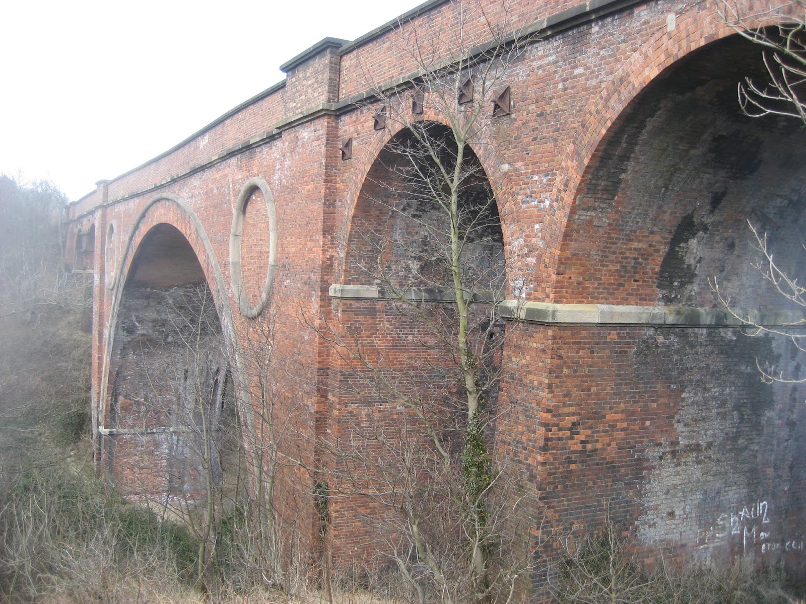
 Brick built viaduct at Fox Holes. tremendous piece of civil engineering.
From here on the path stays close to the cliff edge, crossing the railway at Hawthorne Dene and a little further on crossing back to the seaside of the track.
 Railways need fences but they could have erected something a little more attractive.
The next ex-pit on the walk is Dawdon Colliery. After that we joined the road and walked into Seaham and the car park.
 Seaham harbour, constructed in 1828 to export the coal from the mines owned by the Londonderry family. Very quiet now, there seemed to be some scrap being loaded but little else.

 Not a huge fan of outdoor art but I like the stuff we have seen today
 This wonderful statue of a World War One soldier was made by local artist Ray Lonsdale. It says it all about that conflict. The same artist made a statue, placed in North Shields, commemorating those fishermen who have been lost at sea. Made from steel, real art that says something.
Seaham also has a connection with Lord Byron, poet, politician and a hero to the Greeks. I know little about his poetry but he was a bit of a lad. Got into Cambridge without even taking his A levels and supposedly kept a bear in his room as dogs were not allowed.
His daughter, Ada Lovelace is far more interesting. She worked with Charles Babbage on his calculating machine and is reckoned to have written the first computer programme, without coding!
 St Mary's church in Seaham, late 7th century origins, one of the oldest churches in Britain
 Seaham Hall where Byron got married.
 More art representing mines


Contains OS data, copyright. Crown copyright and database right 2020
Apologies for the poor map, I'm having problems with the scanner
This beautiful cliff top ramble is about 12 miles of gorgeous Durham coastline and history.
One of these day they'll walk all over U(K)
Another week of lockdown, only local walks from home permitted so here's another virtual stroll, this time on the coast in County Durham.
The walk starts from Crimdon, south of Seaham and to get there requires the skills of the routemeister. The choices are:
If there are only a few, drive in two cars and leave one at each end of the 12 mile walk.
Drive to Seaham, take the bus to Crimdon and walk back. (Arriva 23 from Seaham)
Metro to Sunderland, bus to Seaham and bus to Crimdon.
As there is a full turnout on a warm, sunny day with a gentle cooling breeze from the south we have elected to go by car to Seaham. There is a large car park, with art work, a nearby cafe for breakfast and a short walk to the high street to catch the bus to Crimdon.

A short walk behind Seaham Hall brings you to the bus stop.

We queued in an orderly fashion, as Britons do, showed our go anywhere passes to the driver and took the bus to Crimdon caravan park, start of the walk.
Off the bus we walked a short distance back on the road before turning right, going under the railway that runs parallel to the coast, and reached the Durham Coast Path which is also part of the England Coast Path. Initially we thought of walking on the beach and scrambled down to it. Thinking there could be problems or an incoming tide we changed tack and scrambled back up to the cliff tops.


Until the 1980s/90s this area was part of the Durham coalfield. Some of the mines went under the sea, much of the waste was dumped on the beach. Miraculously the area has been cleared, landscaped and grassed, it is difficult to imagine the industry that was carried out here.
The first Gill we came to was The Blue Houses Gill, close to the site of Blackhall Colliery and one we had to walk round.

We continued our walk on the cliffs for a couple of easy miles, passing Durham Coast National Nature Reserve, enjoyed by the birders, until we reached Castle Eden Dene where we descended to sea level and on a convenient pile of timber decided to have a Herbie.


Lunch over we walked along the beach for a short distance before climbing back up the cliffs (on a footpath!) and walked on to Blackhills Gill and Warren House Gill which is an area of Special Scientific Interest. Magnesium Limestone is home to a few specialised families of flora. The local colliery was Horden, there is also a grasslands Nature Reserve there.
Although the mines in the area have closed there is evidence of the past in the art work on the cliff tops.


Moving on and several mini denes and gills later we came to Fox Holes Dene which goes well inland and we had no choice but to walk round it, coming close to the site of Easington Colliery.

From here on the path stays close to the cliff edge, crossing the railway at Hawthorne Dene and a little further on crossing back to the seaside of the track.

The next ex-pit on the walk is Dawdon Colliery. After that we joined the road and walked into Seaham and the car park.


Seaham also has a connection with Lord Byron, poet, politician and a hero to the Greeks. I know little about his poetry but he was a bit of a lad. Got into Cambridge without even taking his A levels and supposedly kept a bear in his room as dogs were not allowed.
His daughter, Ada Lovelace is far more interesting. She worked with Charles Babbage on his calculating machine and is reckoned to have written the first computer programme, without coding!


Apologies for the poor map, I'm having problems with the scanner
This beautiful cliff top ramble is about 12 miles of gorgeous Durham coastline and history.


