Translate

Sunday 28 February 2021

Back in College

 Back in College.

 We may well be playing out by the end of march, visiting pubs in June! Meanwhile this week's reminisce is a walk in the College Valley in Northumberland. All the Cheviot valleys are beautiful in their own way but the College Valley is a personal favourite. Nothing to do with studying the name comes from "letch" meaning a slow moving stream in marshy ground and possibly col meaning cold. 

The valley is privately owned. Only a dozen cars are permitted to drive down it a day and to be one of the lucky ones you need a pass from John sales and Sons, estate agents in Wooler. They cost £10 and for all I know the valley may be closed at the moment. There is a car park at Hethpool, at the valley entrance, free and a good place to start a walk.

To get to Hethpool: A1 north A697 at Morpeth, drive past Wooler and turn left at Millfield. After a few miles turn left at the sign post  for Hethpool and drive another four miles to the hall and a row of cottages. The car park is just beyond the cottages. The map is OS OL 16 Cheviot Hills.

Hethpool was the home of Admiral Lord Collingwood who took command of the Royal Navy when Nelson was killed at Trafalgar in1805.

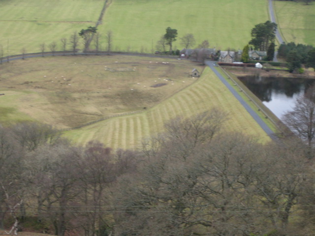
Hethpool takes its name from the number of hillforts or Heths in the area, the first two, on the right of the valley are Little Hetha and Great Hetha.

The walk, at last.


 The now traditional car park view and information boards nearby.

We followed the road, almost due south and close to the College Burn, sluggish as it is so far down the valley.

The walk passes Cuddystone Hall. available for weddings but only five guests at the moment and probably closed anyway.


           Cuddystone Hall, beautiful views across the valley as a reminder of your special day. This is an old photo, it's whiter now as befits a wedding, and you get a marquee outside too.

Beyond the hall is a memorial to the men of the RAF and USAAF who were killed in crashes on the hills during WW2. On the memorial a map shows the spot of the crash sites.  The remains of one of the planes, an American B19 is plainly visible on the Cheviot, just off the main footpath.


                                Memorial stone and map

A little further on we came to a fork in the road. Going right takes you to Mounthooly, once a farm, then a Youth Hostel and now a bunkhouse. As the area is part of the Northumberland Dark Skies I think it would be a great place to stay on a clear night.

But we took the left fork, crossed the burn and headed for Sothernknowe.


                     Sothernknowe and a phone box, one of the few remaining in the UK thanks to mobiles and a reluctance by BT to subsidise them.

A short distance beyond the farm there is a footpath on the left which we followed uphill first climb of the day. At some point not marked on my older map a path leads off almost due north to Hare Law which has a fine cairn and good views over the valley.

                            Hare Law cairn. Such good views and shelter from the breeze, it made an ideal Herbie Spot; As usual we shared fattening goods, flapjacks, almond slices, ginger biscuits, Titan chocolate bars and cake from Mrs A.
Moving on, roughly north east we headed for Wester Tor, rocky outcrop with a Devonian name.And from this point we followed the footpath to Easter Tor, slightly lower than its mate but reached by a good path.


                        Another Tor and a view of Hethpool Hall and pool.
Walking on we came to St Cuthbert's Way and turned left, crossing fields to Torlee House Farm.
                A not very good shot of one of the Cheviot feral goats
                                                    Torlee House

                     The work of a hungry horse at Torlee.
From Torlee we followed St. Cuthbert across fields and through woodland, crossed the burn by a footbridge and returned to the car park.
On the way home we stopped to rehydrate at the Shoulder of Mutton in Longhorsely, as usual the pub had several fine ales on offer.
The walk is about 10 miles with some climbing, but some downhill too.

                                 Contains OS data, copyright. Crown copyright and database right 2021

And some views;


Saturday 20 February 2021

A wee walk from Wolsingham in Weardale

 A wee walk from Wolsingham in Weardale.

Still in lockdown the nation waits for limited release to be announced by Boris Badunov on Monday February 22nd.

To keep my spirits up and perhaps those of others I have revisited a walk done sometime last year. It's fairly easy going, family walk, tables for a picnic too. The walk starts and finishes in Wolsingham, a market town in Weardale County Durham.

The name is derived from that of a Saxon family who lived here, Waelsingas, meaning, apparently, "the sons of Wael". The locals worked hard producing food for themselves and for the Bishop of Durham who spent a lot of time hawking and hunting red deer in the area. The Weardale hunting forest was second only to the New Forest in size. The bishop had his palace in Bishop Auckland, a retreat at Beau Repair (now Bear Park) and a Sunday job.

To get to Wolsingham from base: A69 west A68 South, watch out for signposts for Stanhope and turn east through that town. There is a free car park close to the Waskerley Beck in the Upper Town and also one on the A689 heading west.

The walk is covered by OS Explorer 31 North Pennines and OS Explorer 307 Consett and Derwent Reservoir.

            Parking and preparing in Wolsingham close to the Waskerley Beck. (Heading south! it would be a burn in Northumberland)
But before we set off we breakfasted at the welcoming Number 10, a short distance from the car park, which did a great line in bacon sandwiches.

                                     Ben and Harry outside number 10. 
Filled with food we set off, staying on the footpath on the south side of the beck. After clinging close to the bank and passing waterfalls we headed north west (315 degrees) on a footpath across the fields passing through the High Doctor pasture to park Wall where we turned through a right angle and headed north eastish past High Joffless towards Tunstall Reservoir.
                                  The start

                          Or is it?
                          First sight of Tunstall Reservoir
Having reached the Reservoir Dam we walked alongside the water to a site which contained a hut for fishermen and several picnic tables, seemed like a good spot for a Herbie.


            With a full turn out we fed well. Ginger biscuits from Ben, apple pies, flapjacks, almond slices, cookies and chocolate cake from Mrs A.

Lunch over we struggled on to the north end of the reservoir  where we headed south through Backhouse Wood.

                   A weak and watery sun over Tunstall Reservoir
The walk here is alongside the reservoir through Backstone Bank Wood to Backstone Bank itself.


               A walk in the woods. Well manicured dam too.
From Bankstone Bank the path is across fields for a little over two miles back to Wolsingham passing Baal Hill House and Hollywood and a Holy Well. (See last three photos)  At the edge of the town is a footbridge and once over the car park is close.

On the way home we stopped at the Boathouse pub in Wylam. In dreams


Contains OS data, copyright. Crown copyright and database right 2021

The walk is about 7.5 easy going miles.

                      So good I put it in twice.