Translate

Wednesday 30 April 2014

One cuckoo flew over a warbler's nest..April 29

Another book I had as a child was a small bird book with stories about two small children who were taken out into the country by their uncle Peter and shown a variety of birds and given explanations for their behaviour. Peter wore a jacket with elbow patches and smoked a pipe. He supposedly worked in an office, (don't they all) but I think he was a Geography teacher. I can;t remember the title of the book but it taught me a little about birds and their behaviour. My favourite bit was the rooks' parliament but I still haven't seen one.
No uncle Peter today but Dave and I are having an extra gadgie walk along the north shore of Kielder.
Dave is very knowledgeable regarding birds, he can recognise a mandarin duck from 110 yards without binoculars and we are hoping to spot at least one of the ospreys that are on the lake.
This walk has been covered twice before:
A case of Deja Vu, 7/6/13 and The Kielder Sanction 1 26/11/11 but to recap.:
Kielder is the largest man made lake in Europe, surrounded by the largest man made forest in Europe. It was built to supply water to the northern industries but they have gone into decline so now it is also a tourist attraction with fishing, yachting, walking and cycling. A good hard track has been built circumnavigating the lake, used by walkers and cyclists.It is about 27 miles round and is used for a marathon once a year.
Our walk today is from Kielder Castle at the north end to Falstone village at the south. It is therefore linear and requires either two cars or a bus. We have chosen to drive to Falstone and catch the 880 bus that runs from Hexham to Kielder. If you want to do the walk by bus the 880 only runs on a Tuesday Friday and Saturday and it is worth checking with the operator, Howard Snaith that it runs into Falstone.
To get to Falstone from base take the A69 west and follow the brown signs for Kielder Water, turning right into Falstone just south of the dam.
A pretty village with cafe, pub playing fields and churches and friendly inhabitants.
                                                     Not exactly a car park
                                                       United Reformed, Falstone


                                               Pub, handy for the                                               Anglican Church
                                                   Horse drawn potato digger

                         The bus takes about 15 minutes to get to Kielder Castle.
                                           The Cunningham Cottage, Kielder
                                     Once a hunting lodge for the Duke of Northumberland
                                        the castle is now a cafe and exhibition centre. It has a web cam on the
                                       osprey nest.
                                            Plenty of sign posts to guide you on your way
You can do this walk without a map but OL42, Kielder Water and Forest covers the route but a map from the information centre showing the art installations is probably better. The castle is at NY631934.
                               The Duke in his study, helping to plan our walk
Having had a look round the castle, (note no bacon) we set off, walking down the path past the minotaur maze. Ignoring the sign for the north shore we headed for the Kielder Viaduct, another fine example of Victorian engineering on the old railway line that once served the North Tyne Valley. Much of the line is now beneath the water but the viaduct was saved from demolition and provides good views above the woods and the beginning of the lake. It has several wrought iron panels too;
                                                      Minotaur Maze
                                                    Panel on the viaduct
 Once across the bridge we joined the north shore footpath and began the meandering walk back to Falstone, watching out for birds in woods, on or in the water, or anywhere else.
The north shore is, I think, the better walk as it is away from activity centres and the road, although there is no escape if you have a problem, unless you are near one of the jetties and the infrequent ferry is running. There are, however, several works of art, described more fully on the previous blogs and generally ignored today. The first one is Silvas Capitas, in a wood off the track, but well signed.
Silvas Capitas, wooden top.
The next one is called Viewpoint and represents the symbol on OS maps for viewpoints. It looks like large pieces from Trivial Pursuit.
At the next work of art, The Janus Chairs, we stopped for lunch. The chairs are very large and rotate. We arranged them to give a view over the lake and reclined, eating our sandwiches and enjoying the view. We were joined by a young couple from Somerset, out enjoying the north of England. The young man explained the mysteries of Garmin GPS systems to me, he had had the same problems I'd  had. I am now a little wiser.

                                                     
                                                            Information on the chairs.
Moving on we had the bird sight of the day. First we heard it then we saw it. A cuckoo. I have often heard them but never seen one before. Sitting on a power line it appeared to be watching the field below and occasionally dived down to the grass, stayed about a minute and flew back to its perch. Possibly scouting out a willow warbler;s nest Dave explained.
Walking alongside the lake,watching the water for a hunting Osprey, we reached Robin's Hut. On the north shore lies this hut, on the south side lies Freya's hut. Those of you who recall Johnny Preston singing Running Bear (1960) will have an idea of their story, except in this case Robin had a boat.
                                                    Robin's Hut..............
                                         ..................looks at Freya's across the water.
Pressing on around the lake we ignored The Belvedere and The Wave Chamber, eventually reaching the dam. From here there is a road to Falstone but by the Forestry Commission Cold Store a footpath takes walkers across fields to the village.

The Matrix MMXIVN

                                                                       steps                              miles

Dav;e LIDL 3D                                                26292                               13,292
           USB                                                      26293                               12.09

My LIDL 3D                                                    28275                                13.09
ASDA CHEAP (From Janus Chairs                 18845                                8.85
Garmin (from Janus Chairs)                                                                        8.06
Gadgie distance is now 181 miles

List of birds
Cuckoo, Songthrush, Mandarin Ducks,  Greylag geese, Canada Geese, Heron, Goosanders, Willow Warblers, Chaffinches, Chiffchaffs, Mallards, Robin, Greater spotted Woodpecker, Green Woodpecker (both heard but not seen)    BUT NO OSPREY!!

A KIELDER GALLERY


                                           Two sides of the same post


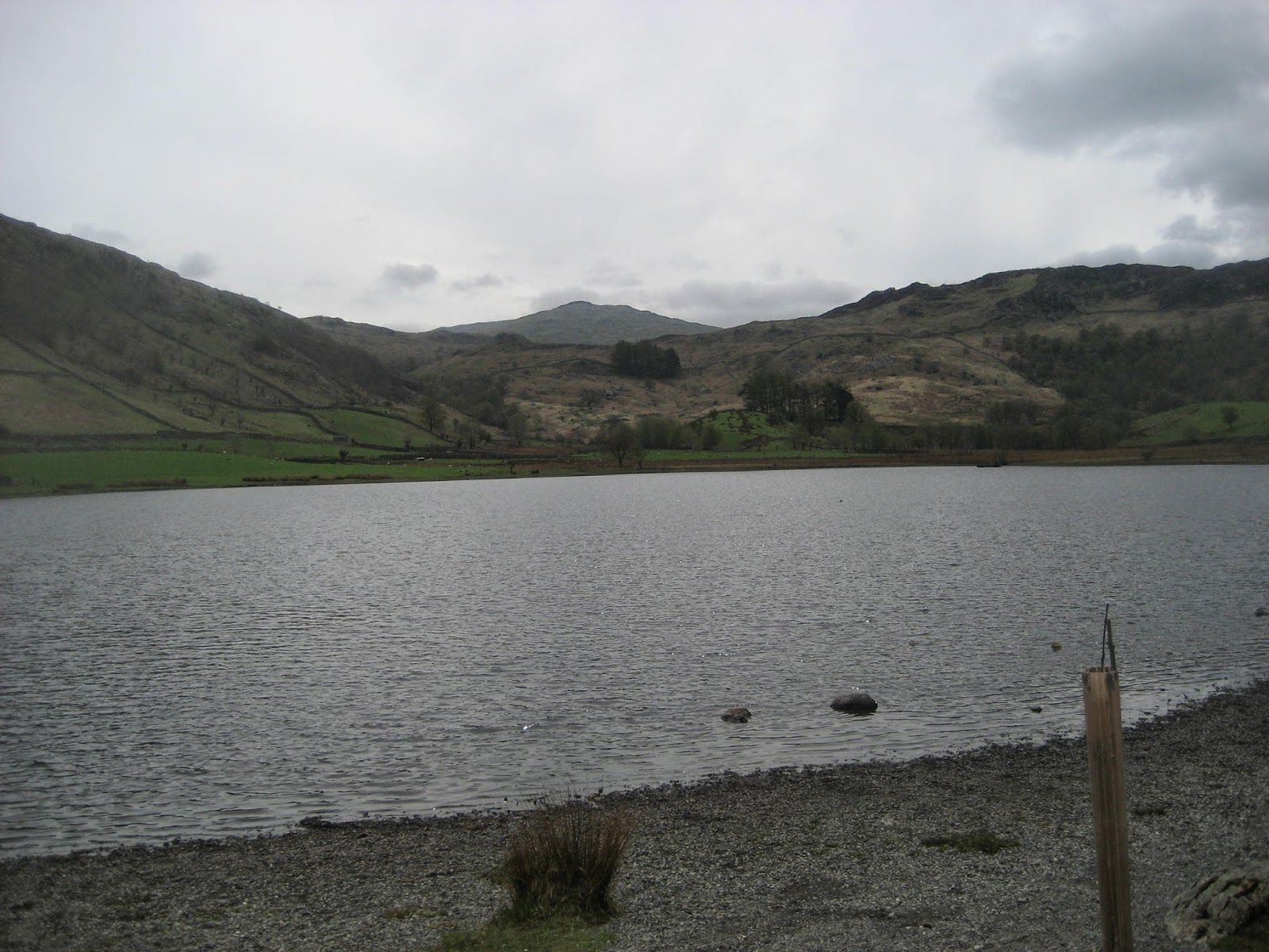
                                                          Looking down the North Tyne Valley


Kielder Water
                                     And before the dam was built (opened by HM Elizabeth II in 1982)
For both maps:
Contains OS data copyright. Crown copyright and database right 2014

And the bird of the blog:
The cuckoo.

Saturday 26 April 2014

Barn at the end of the Lake...............April 25th
 One of the many books I loved as a child was Fell farm for Christmas by Marjorie Lloyd, published in 1954. A companion to Fell farm Holiday it was a simple story of a family of children enjoying a Yuletide romp on a hill farm. Much more fun than The Famous Five, by Enid Blyton although I did read and reread her Shadow the Sheepdog. I have often wondered which farm Marjorie used as a model, could it have been Watendlath which is the chosen walk of today?
 Watendlath comes from Old Norse vatna endi hlada,  meaning "the barn at the end of the lake" or possibly, "the lane to the end of the lake". I vote for the former.
  There are five of us out today, Dave, John, Brian, Harry and me and w
e have chosen this short walk in the Lake District because the weatherman has promised heavy rain in the afternoon and the north east is shrouded in mist and it's not even autumn.
The starting point is at the car park in Rosthwaite down Borrowdale. To get there from base : A69, M6 South, A66 to Keswick, follow signs for Borrowdale, but do stop at the Keswick coffee lounge for a grade nine bacon sandwich and tea. (Or try the Flock Inn up the lane from the car park, it specialises in Herdwick sheep products as well as bacon and is popular with HRH the Prince of Wales). The car park is not free unless you have joined the middle classes  and can display your National Trust card on the windscreen..

The map to use, and it is advisable, is OS OL 4 The English Lakes North Western Area and the car park is at NY257148(approx).
                                               National Trust car park. Next to it is a small
                                             car park belonging to the village institute and
                                              available for a donation. It has a mysterious
                                             request to park facing the wall.
The walk:
  We left the car park and walked down the lane back to the village, turned left and almost immediately right up another lane, crossing the Derwentwater Beck by means of a beautiful arched bridge.
                                                A bridge over Derwent Beck water.
From here we followed the steep path between Belt Knot and Yew Crag, past the well named Resting Stone, and down Bowdergate Gill towards the hamlet of Watendlath. (It is possible to drive to the hamlet from a point off Derwentwater near a landing stage some miles north of Rosthwaite. Popular because it gives people the opportunity to visit the Lodore Falls, not exactly Niagara, but pretty)
  There is a tea room at Watendlath and it is possible to fish on the lake. It is a very peaceful place and very pretty. Could be the fell farm of the book for all I know.
                                            Watendlath farm
                                                        Watendlath tarn
                                   Looking back at Watendlath.
The next stage of the walk took us to Dock Tarn. It is easy to find as there is a signpost at Watendlath pointing the way along the west side of the tarn. If you follow this walk take a good look at the map and find the footpath that leads directly to the tarn. Some of us are so confident that we know the way we wandered around Great Crag and the Knotts before reaisling we were off piste. Turning instinctively east we found the elusive Dock Tarn. (Brian who had decided to take a slightly different route sat smugly on the shore, snoozing.)
We declared a Herbie Spot and sat on rocks on the east side of the tarn. Sandwiches, chocolate cake from Miss E of cakepoppins fame, chocolate biscuits, Mr. Kipling's somethings and Mrs A's weekly offering. ( I apologise Margaret I have forgotten the flavour, it's my age).
                                    Dave, Harry, John and Brian lunching at Dock Tarn.
                           Dock Tarn and Brian's hat. There were some mysterious objects moving just 
                                        below the surface, possibly mini submarines sent by Vlad Putin
 Lunch over we considered hiking across th Ullscarf but decided that by the time we got there the rain would have set in so we followed the path south west to Lingy End. Here the path goes very steeply downhill through a wood. (Or uphill if you go the other way of course.) The footpath has been very well built up with large stones but it could be a problem in wet weather, and a nightmare in icy conditions. It emerges in the Derwentwater Beck Valley near the campsite. There are some top class stiles on the way too.
                                                      Great Gable with gathering clouds
                                                              Wooden stile.
As the path levels out we came across one of the Lake District;s finest wall crossings and I have persuaded Harry to demonstrate the correct way of crossing.
                                                               The stile
                                                             The approach, taking care
                                                  if using walking poles, or you may trip. It would be 
                                                 advisable to retract your poles and strap them
                                                  to your rucsac before attempting to cross the stile.
                                                   Not wearing a rucsac? How will you carry the 
                                                    essentials for a walk; spare clothes, food and drink
                                                  iphone, ipad, camera, portable printer etc
                                                            Take one step at a time
                                                           And cross safely, remember
                                                       stiles are not to be trifled with.
I am thinking of sending this series of pictures to the Health and Safety Executive.
The footpath joins the Cumbria Way, the walk back to Rosthwaite is between dry stone walls and alongside the river. The only thing to watch out for is the dog owners and their pets. They own the path, apparently.
                                                      Dry stone walls, called rock fences in
                                                          the North American Dominion
                                                         
                                                     Views along the river.


                                           Herdwick major and minor. These sheep are black at birth
                                            grey at one and brown at two. Well known for hefting which means they 
                                           stay on their own patch in the hills.
As we reached the car the rain began to fall, the weatherman was spot on. On the way home we stopped at the Shepherd Inn at Langwathby which offered Independent Lakeland Brewery ales,
Old School Brewery Caretaker, Tirril Brewery beer and Thatchers,(witches brew probably).

It was a very bad day for pedometers and GPS systems but in total, with a bit of wandering we managed about six miles. A short but pleasant walk with a couple of stiff climbs.
Gadgie Distance is now 168 miles

                                          Steep descent at the end

Saturday 19 April 2014

The Border Reivers..............April 18th.
  The charming young lady who read the weather forecast promised us a bright sunny day, if cold, so we settled on the walk we chickened out of because of heavy rain a few weeks ago and headed for Windy Gyle on the English and Scottish border. (Hannah, if you read this, thanks for the birthday present. It was a complete surprise, but we all loved it!)

 To get to the start of the walk from base: north on the A1, turn off north of Morpeth on the A697, follow the diversion signs for Rothbury, continue west to the signpost for Alwinton, drive through that village, past Barrowburn and park at the bridge by the Rowhope Burn. Room for a few cars, and free.
The map that covers the walk is OL 16, The Cheviot Hills and the car park is at NT 859114, approx.

Naturally we stopped for breakfast at Tomlinsons Cafe and Bunkhouse in Rothbury for a bacon sandwich; it scored a 9 on the new Michael Gove inspired points system, the tea was good too.

Because it is a public holiday there are only four of us gadgies out today: Harry, John, Brian and me.

This part of the British Isles is the border country between the peaceful English and the aggressive Scots and from the 13th century to the union of the crowns was bandit country, both sides invading each other, stealing, destroying and probably carrying out other unmentionable deeds. They are generally known as the Border Reivers,* both sides occasionally made efforts to control them, not always successfully.  The "clan" names linger in the north east: Kerrs, Robsons, Armstrongs and Collingwoods to name a few. I suppose there is a possibility that the descendant of one tribe made that first small step for man.


The walk: (at last)
                                              NT 859114 (approximately)
  The sign post visible at the right of the picture points towards Rowhope and is not the route we followed. To the left of the three gentlemen standing passing the time of day a gate (or a stile) led us to The Street. This grassy track is probably an old drove road, used by both sides to bring cattle to market in the more peaceful periods, today it is used by walkers, mountain bikers and shepherds.
                                                   Looking back and down at the car park.

                                      In this area of the Cheviots there are the ruined remains of at least four                                                    whisky stills hidden away in the remote valleys.
          Starting roughly west the path climbs quite gently but steadily, turning north west then almost due north as it crosses the Black Braes. Often clarty as they say in the north east, today the path is dry. As it nears the border the track turns east and joins the Pennine Way, the English Long Distance Path that ends just over the border. We called a Herbie Spot and sat on a grassy bank, warmed by the sun and coffee, as we dined on sandwiches, chocolate, Mrs A's home made Kumquat and marmalade cake and fruit and yogurt breakfast bars. (191 pounds this morning).
         

Eating over we continued on our way climbing slowly to Windy Gyle and Russell's Cairn. On the way we met a small herd of the feral Cheviot goats.. There are at least three herds in the hills, this one must have been a sub herd as there were only five.

                                                Billy goat rough.
 We stopped at the cairn to admire the panoramic views; Scotland to the north and west, Cheviot and sea to the east and Simonside to the south.
There are two theories for the name Russell's Cairn. One states that it was named by Alexander III, king of Scotland in 1252, for Sir John Russell an English knight as they were riding out together in a peaceful moment between the two countries. The other says it is named for Lord Francis Russell who was murdered here in 1585 at a meeting with his Scottish counterpart as they were supposedly discussing peace. Archaeologists say it is a bronze age burial cairn.
                                 Russell's Cairn. The trig point is an added extra, presumably

                                             Gadgies John (in a sun hat!) and Brian pose for 
                                                     Kathy from Goole.
The weather forecast was slightly out, it was very warm and at this point top layers were removed and we continued with fewer layers. Break over we continued  down the Yorkshire mill yard path roughly north east to Cock Law Foot.
                                                       My daughter thinks I have a thing about stiles, so here's one.
                                Scotland on the left, England on the right, and a sign banning
                                 cars and motorbikes between April 1st and May 31st.Lambing time.


                                           Clennel Street is another drove road
                                         This is the border fence. Will it change if the
                                           Scots gain independence from the UK?
 At Cock Law Foot we took the path going south east before turning south and meeting the road that runs from Rowhope to Uswayford. We opted for the road  that goes south west. Just off the road on the left at Trows Plantation is Murder Cleugh:

                                    Poor Isablla, coming to a sad end shortly after the
                                  uniting of the kingdoms brought peace to the borders.
(Copyright Phil Thirkell and licensed for use  under this Creative Commons Licence NT8613)

Walking back along the farm road the discussion turned to steam engines for some reason, probably because of the recent exhibition of A4s at Shildon, one being world speed record holder Mallard .
Brian observed that Elvis had sung about steam engine; Love me Tender.
Soon, fortunately, we were back at the car. As we were changing two of Harry and Brian's colleagues, Emma and Taj appeared, so we agreed to continue the conservation in the Rose and Thistle, the village pub in Alwinton. It served a very refreshing pint of Tyne Blonde. For some reason John maintained he had had no specific aim in life. Brian maintained he had always wanted a cetacean: some porpoise in his life. Emma and Taj left.
We felt we must end the day in the Anglers Arms at Weldon Bridge. They had on Directors, Bombardier and London Gold.

The Matrix                                        steps                        miles
LIDL 3D                                           23477                       10.56
Brian's GPS                                                                       10.4
The new Garmin                                                                10.3

No Dave
Gadgie distance 163 miles


                              Northumberland Views in Border Reivers land.
* Read "The Steel Bonnets" by George McDonald Fraser. (Yes the writer of Flashman books)


The last four photographs are by Harry, routemeister and excellent, prize-winning camera artist.