Translate

Saturday 30 October 2021


Every leaf speaks bliss to me,

fluttering from the autumn tree.

                                                     Emily Bronte

It's autumn and we are off for a familiar walk round Allen Banks to see the colours of the fall, as the area has acres of deciduous woodland. Not up to New England standards but real England. The weather forecast is not too promising, cloudy with rain at 2pm says the Met Office.

I chose this quote by Emily Bronte, author of Wuthering Heights, because I wanted to escape the cliched "Season of mists and mellow fruitfulness " by Keats and anyway I suffered his poetry for O level at a time when you had to remember it and not take an annotated copy into the exam room.

Also I spent a lot of time as a child in and around the Haworth area.

Today a team of seven is out; Brian and Margaret, Dave, Harry, Ben, John H. and me, starting a walk from the National Trust car park near Ridley Hall. Head west on the A69 and turn left near Bardon Mill. There is a charge to park unless you are a member.

The map for the walk is OS OL 43 Hadrian's Wall, a double sided map and the walk is on the edges. 

On the way we had breakfast at Brockbushes farm shop. They were having a Halloween Fair for children (and adults). Rides and pumpkins'

Shame about the rain

The walk, but first; MUD WARNING


National Trust car park. £4 for the day, free to members. There is a shelter, useful for changing and sheltering too. And it has a map

The walk at last.

Leaving the back of the car park, past the shelter with a map we followed the footpath above the river to a gate on the right. Through the gate and across fields to a road where we turned left then right towards the village of Beltingham. A pretty village with a church and everything, including a connection withe the late Queen Mother but we've done that, got the T shirt and moved on, taking the track to Shaws across fields.

Field of maize near Shaws. Possibly animal fodder but some British maize is for humans too.
beyond Shaws we headed for another farm Wool House and then on to a road where we turned left.  Not far down the road we turned down the farm track to Briarwood, passing a field containing some ewes and amorous looking rams or tups as they are known in the north.
                 My mother could never bring herself to say what the ram's harness was for. She always said "You know, to show.... never mind"

   At Briarwood farm we entered the wooded valley of the River Allen.
The footpath down through the wood was covered in leaves, was muddy and slippery, care needed for those with older limbs. At the bottom of the path we crossed a stream and then the River Allen to Plankey Mill.
                         Footbridge over the River Allen at Plankey Mill

                  Herbie time at Plankey Mill. Apple pies, almond slices, cookies, ginger biscuits, a savoury from Mrs A and a very sweet and sticky cake from her too.
Lunch and chat over we headed across the fields by the river, through the gate and off into the woods of Hag Bank. The clouds had thinned, the trees were doing their autumn stuff as we climbed the steep but thankfully short stretch to Staward Peel.
                      The leaves are turning


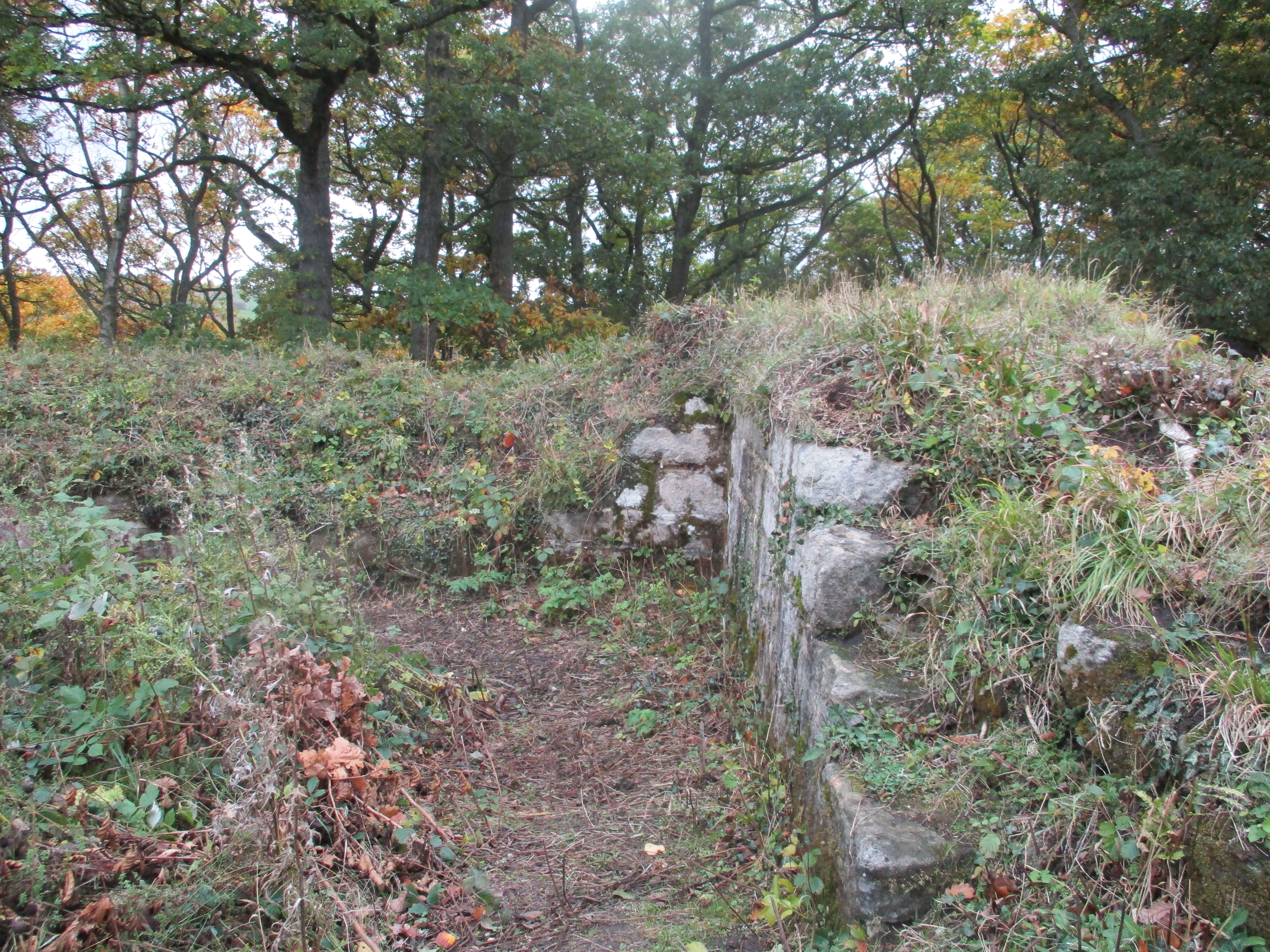
The remains of Staward Peel.
At four minutes to two the rain started and the wind began to blow, just as the Met Office had said. Hoods up and heads down we walked the narrow ridge from the peel to a field and headed south, passing Gingle Pot, once a tavern for drovers, and then to the A686 road close to the old and demolished railway line.
 Turning right we followed the road. Four found the stile that led to the path back down to the river. Three marched on in the rain to the sharp bend in the road. A pick up pulled up, told us where the footpath was and warned us that a number of people were out shooting partridges, beware, don't fly.
The three soon caught the four and we followed the muddy path gently down hill to the river bank. Well behind the others harry and I wandered off the path to admire the trees. The pickup driver and his seven gun dogs put us back on the right trail and warned of the shooting party ahead. We soon heard them but escaped unharmed.


                      On the banks of the River Allen
Eventually we rejoined the path we had taken from Plankey Mill and soon we were back there and the rain had stopped.
Instead of crossing the river we walked a short distance up the road from Plankey Mill and then took the footpath on the left which followed the river bank  back to a bridge near the car park. Over the bridge, back to the park, changed in the shelter and off to the Duke of Wellington in Riding Mill. Several beers on offer but I was a driver. Soda and lime is a refreshing drink sometimes.


                        Contains OS data, copyright. Crown copyright and data base right 2021
The walk is about 10 miles with some steep ups and downs as you can see


Monday 18 October 2021

 Eglingham, Cateran, Blawearie

(Northumberland October 19th)

 Today's walk has been devised by John C. Based on Eglingham, a linear village with a population of about 100, a few miles north of Alnwick, it combines sections of other favourite gadgie strolls.

To get to Eglingham take the A1 north, turn off and go through the town, take the Wooler Road and five miles later park in the village, There is some parking on a lane to the church, (St Maurice, 13th C) and some parking on the roadside opposite the pub, the Tankerville.

The map to use is OS Explorer 332 Alnwick and Amble.

There is a team of eight out today, me, Harry, Dave, John H., John C, Ben, Margaret and Brian.

Start with the usual car park picture;


        Not a prize winner for car park of the year but here we are in Eglingham.

Kitted out, on a dry day after one early shower, we walked up the village street, roughly west until we turned off at a lane near Cockhall. This lane led us to the first and only ford of the day. Sometimes we are advised to take plastic bags for the fords we cross but for this one we made do with the stones, some of which were slippy.

 Harry takes to the water. (Watch this week's video at the end!)

Having crossed the dangerous stream we headed north uphill, then north east until we met a farm track . (mile 1).  Here we turned left and continued towards Harehope, passing a row of bee hives on the way.
                         Beehives and shadow
However along the track we were passed by a convoy of pickups and 4x4s, loaded with guns and dogs. They were off on a partridge shoot on Harehope Hill. Our original plan was to take a path on the south side of the hill but they politely suggested we should head for the "Posh Cow Shed" and take the track to the north of Harehope Hill. They had guns and dogs so we did.


               The wagons circle at The Posh Cow Shed.
There was a short but steep climb up Tick Law, which seemed tick free. On the top we came across a large piece of rock decorated with cup and ring markings.


             Nobody is sure what these ancient markings mean or what they were for. They occur at several Northumberland sites and other places in Europe too.
Not too far further on (mile 4) we came to the remains of the prehistoric hill fort at Old Bewick. Little remains but the inner and outer walls, covered in bracken and reduced in height but still impressive.

                   Old Bewick's ancient ramparts.

                And its modern equivalent. Built in WW2 when it was thought the country could be invaded from Norway there are many similar pill boxes in Northumberland.
Moving on and a little unsure of the track to take we wandered a little, split into two groups and eventually Dave, John H and I found a good track that led north east towards lunch. The other five found a similar track and we met at Blawearie, a ruined farm.
          Blawearie (cf Wuthering heights) was built in the 19th century by the Rogerson family. Abandoned in the 1940s it fell into ruin, but...

This shelter, presumably built for shooting parties, is relatively new and made the best Herbie Spot for a long time. IKEA biscuits, (already assembled) flapjacks, Ben's ginger biscuits, almond slices, sweet and sour savouries from Mrs A..
Lunch over we moved on, taking the track behind the old farm. We headed north east, crossing several streams without the need for plastic bags until we came to a marker post that suggested we turn right and head up Cateran Hill.
A steady climb with several cairns along the way. Near the top of the hill, off to the left is the Cateran Hole.
This is a cave some 30 yards long, entered by carved stone steps. Nobody is sure what it was used for. One suggestion is that it was a tunnel from Chillingham Castle, another mis that it was used as a store for smuggled goods. We have visited it several times and gave it a miss today.
We followed a grassy and rathe boggy path down past Hare Crag (mile 8) until we joined a well made farm tyrack heading south over Eglingham Moor. At Tarry (mile9) the track became a metalled road and soon we were back in Eglingham.
Changed we decided to head for the Shoulder of Mutton in Longhorsely. The hotel had three ales on draught, Timothy Taylor's Landlord, Directors and a blonde. We tried Taylor's but it was the bottom of the barrel so we switched to the blonde.


Contains OS data, copyright. Crown copyright and database right 2021

The walk is about 10 miles with a couple of short climbs


Saturday 16 October 2021

 We're bouncing into Blanchland. (Northumberland)

October 15th.

Another repeat, based on the pretty village of Blanchland, close to the county of Durham. There are seven of us enjoying a beautiful sunny day in the middle of October,  blue skies, no wind, perfect Autumn day for a walk.

A69 west, A68 south and watch for road sign.

There is a large car park close to the village. It has an Honesty Box and of course gadgies are honest.


Getting ready for the walk in the car park at Blanchland. 

Blanchland is on the edge of one map, part of the walk is on another. The two are:

OS Explorer 307 Consett and Derwentwater and OS OL 43 Hadrian's Wall.

The White Monks cafe in the old school makes a good starting point to the walk.


                      White Monks cafe in Blanchland. Good food, nice people.

Having breakfasted we set off  a little way down the village road before turning right on the road to Baybridge. However, to avoid walking on the tarmac we walked through the fields to a junction. From this point on we followed the track to Newbiggin, passing farms and a large house, wooded hillsides, some of which had been replanted, hopefully with deciduous trees until we reached the ruin that was once the farm at Riddlehamhope.


All that remains of  Riddlehamhope farm. Three miles in on the walk it was too early to lunch here although it has been used as a picnic site on previous occasions.

From the old farm the route turns north, passing a sign post for Heatheryburn, we did not follow it but walked on to the farm at Harwood Shield.

                        Not this way on the walk today.

The path goes through the farm yard at Harwood and then across fields to the next farm at Stobby Lee. At this farm we went slightly off piste but regained the track to the next farm at Steel, then Long Lee where again we lost the path. Having regained it we followed a footpath across fields to New House, crossing fields with slippery ladder stiles we made it to Hesleywell before turning east. After about 7 miles I for one was more than pleased when a Herbie was called . We sat on the side of a strange ditch which even the resident archaeologist failed to explain. It didn't matter, it was sunny and warm.


Herbie time; Mince pies, it's nearly Christmas!. Savoury cakes, chocolate cake, slices from Mr. Kipling and ginger biscuits from Ben.

Lunch over we headed downhill to Burntshield Haugh before starting the long climb up Burntshieldhaugh Fell, a heather covered moorland with a row of shooting butts too.

                                       Shooting Butts on Burntshieldhaugh Fell
                                And the track on the same fell.
Turning right at the next track junction we walked down to Pennypie house, so called because in days of yore when drovers crossed the moors with their cattle the farm provided pies for a penny. 
At this point there are two ways of returning to Blanchland, one following the Pennine Journey marked on the OS map or the right fork which we took. This track eventually becomes a tarmac road but some way down, spotting a finger post on the left we followed a footpath across fields to Cote House Farm and the road back to the car park.
On the way home we stopped for a drink at the Derwent Arms in Edmondbyers which used to be the Punchbowl. Refurbished and with several ales on draught it was a good choice too.

Contains OS data, copyright. Crown copyright and database right 2021
The walk is about 11 miles with some climbs and some spectacular views.


And some extra photos;