Translate

Wednesday 31 March 2021

FIVE GO OFF TO BELSAY

 Five go off to Belsay (Northumberland) March 30th

  Lockdown in England has been eased slightly, we are allowed to meet in groups of six or with two families. The team could only muster five, Margaret, Brian, John H, John Ha and me and we are meeting at Belsay for an easy country walk.

Belsay is a small village with a big hall and castle. From Newcastle drive through Ponteland on the A696 and after about five miles you meet the village. As you reach the village there is a large gate, the entrance to Belsay Hall and grounds but turn left instead of entering and there is a small parking area opposite the Blacksmiths Coffee Shop. The cafe is currently open for take away drinks and cakes and very nice it is too.

The walk is covered by OS Explorer 316 Newcastle upon Tyne

                   This week's car park, at the top of the photo. The car on the left is in the cafe parking area.
                  The Blacksmiths Coffee Shop. In normal times there is seating inside and out.
Having had morning coffee we set off. We took the farm track due south from the coffee shop. It is difficult to miss, there is a large sign saying "Belsay Woodland Funerals" and after a few mhundred yards there is an entrance to the funeral woodland but at the moment the trees are saplings.
We followed the track, ignoring the turn into Belsay Hall which is visible in the distance.
                  Distant view of Belsay Hall. Built for Sir Charles Monck in 1810-1817 it supposedly the first building In Britain in the " new" Grecian style. Square shaped with an atrium and room in the roof for the servants. In the hall grounds there is the family's original castle and a beautiful quarry garden. The place is run by English Heritage.

Eventually we reached East Beechfield farm with many outbuildings and a love of sheep.


The path goes through the farm yard and then turns left to cross fields. There are a number of fields to cross and consequently a number of stiles to struggle over. The public way is well marked but some of the stiles are a bit rickety to say the least and need climbing over with care.

                                  Just one of many.
Having crossed five fields we reached West Newham, turned west for a short while, walking the edge of a field, before heading south west until we met a minor road, crossed it and, edged round a field before heading straight across another cultivated piece of ground to the same road. 
We followed the road, crossing the Robsheugh Burn, ignored the road signposted Milbourne before finding a finger post on the left, and more stiles.

                        Robsheugh Burn
Several fields, and stiles, later as we approached High House we chatted to a farmer who was preparing to plant the field with spring barley.

He's ploughed the field and harrowed it and is about to scatter the good seed in the ground.
The footpath goes between houses at High House and into the woodland at the back of Milbourne Hall. A couple of felled trees made for fairly comfortable seating so we called a Herbie.
                      Two Johns discussing Newcastle United's chances of avoiding relegation.
We shared apple pies, flapjacks, savoury buns, chocolate cake and ginger cake. Walking with gadgies, the only exercise where you put on weight as Brian says.


                    Milbourne Hall, built 1807/9 with stone from Belsay quarry.
As we lunched we saw a nuthatch and heard a woodpecker. Moving on across fields and stiles we reached the church in Milbourne, walked through the church yard and turned left on the road.

                       Church of the Holy Saviour, Milbourne, Built in 1879 by a member of the Bates family of Milbourne Hall.
We walked along the road, down the hill, crossed the Mill Burn and almost immediately after went througha blue gate. The footpath followed the burn for a few hundred yards before heading due north across fields and stiles. As the path crosses the Cog Burn the way goes round a small pond quite devoid of bird life but with many a tripping bramble.


                            Small pond devoid of bird life.
The footpath heads due north across fields to East Newham where we turned left on the road. At Middle Newham we headed north across fields, a medieval village and more stiles until we arrived at East Beechfield and from there on the farm track to Belsay, an afternoon coffee and, as pubs are still closed, we went our separate ways home.


                          Contains OS data, copyright. Crown copyright and database right 2021

This country walk is about 8.5 easy going miles.


Saturday 27 March 2021

We're on Matt Ridley's Ground

 We're on Matt Ridley's Ground,

Picking up gold and silver ! (Northumberland ) 

March 26th.

One of the last days of full lockdown, next Monday we can meet in a group of six for a walk but today it's Margaret, Brian and I doing another local walk from Stannington, a small village a few miles north of Newcastle and just off the A1.

The walk is covered by OS Explorer 316 Newcastle upon Tyne.

                        There is a large car park next to the Ridley Arms pub that serves the village hall. Very quiet today, and free.
Booted and wrapped against a steady westerly breeze we started off down the village road which used to be the A1. On a section that leads to a dead end we spotted the sign post on the right and headed off across fields in a westerly direction, right into the wind. The fields had evidence of large scale ridge and furrow from medieval times or even before so it was a bit of a roller coaster walk.

                                  Footbridge close to the start.
We left the fields and entered Catraw Plantation, part of the Blagdon Estate. The route was well marked with at least a couple of large signs with black arrows on a white background pointing the way. We obligingly followed the markers to Bellasis Farm and then on across fields to Bellasis Bridge.

                    Bellasis Bridge. I've cycled over it often but this is the first time I have walked over it. It is very narrow and oncoming traffic is not easy to see. The river it crosses is the Blyth.
We walked south along the road from the bridge before turning left to the Cheese Farm at the delightfully named farm Make me Rich. Unfortunately, because of covid the cheese farm and tea room were closed, a shame, they make tasty cheese for Grommit.

                        Northumberland cheese farm.
From the farm we followed a good track alongside a plantation, crossed another track and came to the farm at Bog House, another interesting name. The path went round the farm and then on, on well marked tracks to Home Farm.  Further on we came to New Kennels. There is a mini business park here, including the Northumberland G
Heritage shop. Presumably closed today.
And then we were at the A1. We walked north alongside the road for a while to a marked pedestrian crossing. The A1 is a busy road with fast moving traffic and needs crossing with care. Fortunately it is a dual carriage way which makes crossing a little easier using the central reservation.
Once over we walked a short distance north before turning into the woodlands bordering both banks of the River Blyth.
                     Peaceful woodland walk after the noise of the A1

          This wonder of Victorian engineering carries the main East Coast line between London and Edinburgh. We waited to see a train. Naturally one thundered over when we had moved on.
  The footpath follows the river bank through woodland. The edges of the path were lined with anemones and celandines. There were a few birds singing but mostly we met dog walkers. Mostly off leads too, the dogs that is.
When we reached the Plessey Woods Country Park we called a Herbie at an area close to the river which has wooden staging. Useful for small children hoping to catch tiddlers and older people wanting a swim.

Herbie time at a table just beyond this spot. Titans, savoury flapjack and Maid of Honour tarts from Mrs A.
After a late lunch (seven miles nearly) we continued east a short distance before turning back on ourselves, climbing up the bank towards the visitor centre and then following a footpath on Stannington Banks. It was quite high up with a good view of the river below. We saw three deer and heard a woodpecker. Eventually the path headed back down to the river and we retraced our steps along thje bank, passing under the railway again, crossing the A1 carefully again and heading back to Stannington. The Ridley Arms was sadly closed of course but they were advertising a Friday evening fish and chip take away service. Tempting but it was only 3.30 pm so we went home.

                     Contains OS data, copyright. Crown copyright and database right 2021

This lovely woodland and country walk, mostly on the Blagdon Estate is 10.2 easy miles.


Tuesday 23 March 2021

Rising Sun Country Park

 The park of the Rising Sun. (North Tyneside)

March 22nd.

On March 29th we are allowed to meet and exercise in groups of six. Today the usual three, Brian, Margaret and I are walking locally from the Rising Sun Country Park in North Tyneside.

Built on the site of the Rising Sun Colliery which closed in 1969 the park has a large pond, a small hill and plenty of trails for walkers, dog walkers and families with small children. And there is a cafe which closes at 3.00pm at the moment.

The park is behind ASDA supermarket on Whitley Road, the entrance just to the east of the of the store, the car park about a half mile down the road. 

The map for this urban/rural walk is OS Explorer 316 Newcastle upon Tyne.

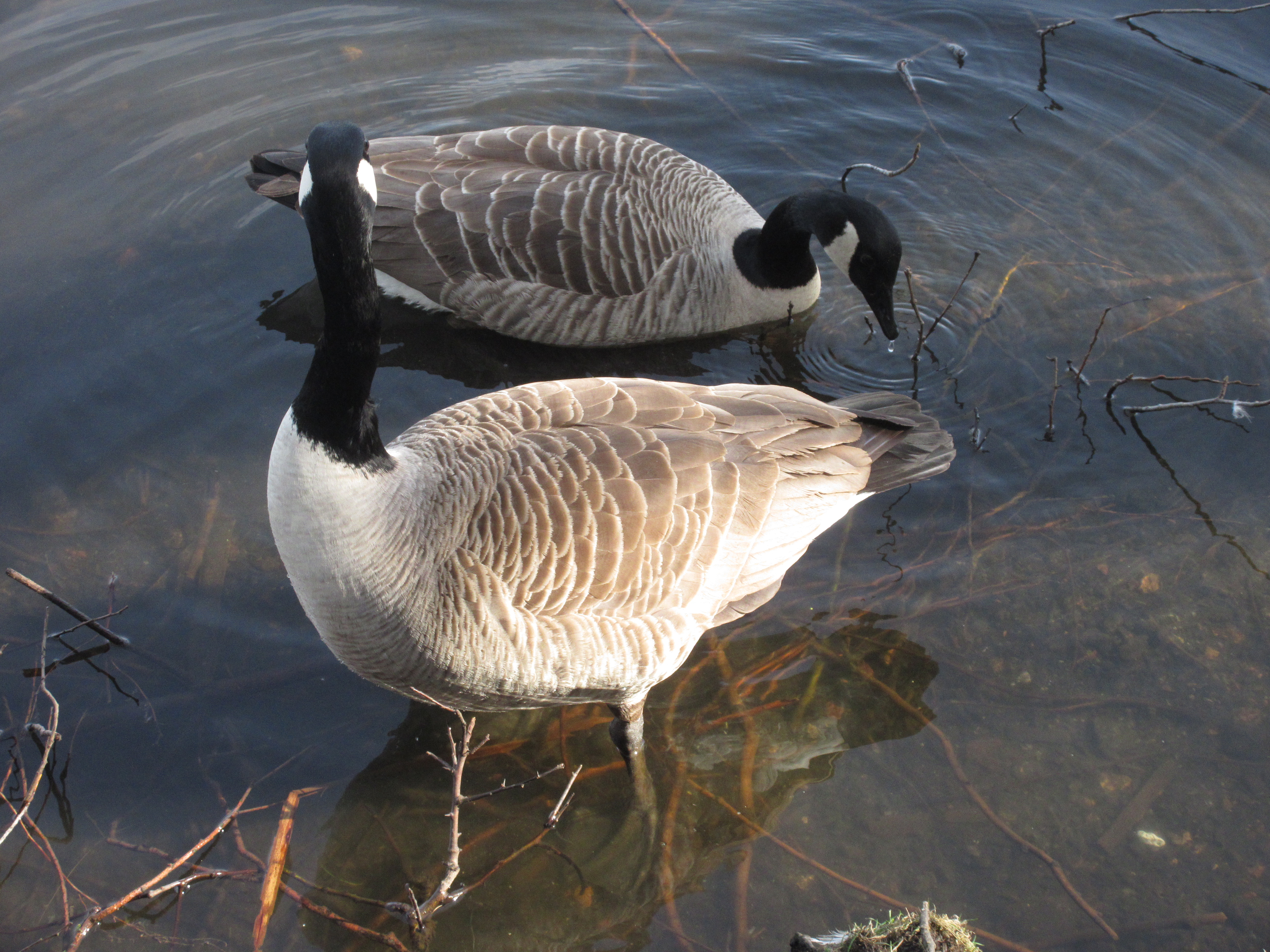
                 This week's car park at Rising Sun Country Park. Free. If it's full you can park at ASDA and walk down the road to the park.

Leaving the car park and visitor centre we started the day walking round the Swallow Pond to the bird hide on the south side. There were quite a few water irds on the pond including tufted ducks, golden eye, moorhens and mallards. Plus geese.


                      Life on the Swallow Pond.
After a while and a chat with a serious camera man we walked up the hill which is the old pit heap. One of the three high spots in North Tyneside it has views in all directions, south across the Tyne, north to the Cheviots and a glimpse of Northumberlandia's nose, east to the sea and west to Newcastle.
Having admired the views we walked back down the hill and followed a track through Battle Hill to the A19. Fortunately there is a footpath beneath the road.
The footpath through Battle Hill has several large stones with pictures of miners' gear. Some have been vandalised but here's one of them.


After a short distance on a path parallel with the road we entered Silverlink Business Park, supposedly one of the largest in the UK. Close to the offices was a block of shops including the nation's favourite maker of pasties, Greggs. We called a halt for coffee.
Moving on we came to the Silverlink Biodiversity Park which includes the third of North Tyneside's three peaks, the Sundial.
                                  Sundial gnomon in Silverlink Park.

                               The shadow says the time is about 12.20. It's a bit fast
Leaving the biodiversity park and its small ponds we followed footpaths to New York Road, turned right and stayed on the road for a short distance before turning left at a pub and walking to Murton Village.
Turning left at The Robin Hood, another sadly closed pub, we walked round the edges of fields, crossed the Tyne Wear Metro line (carefully) and walked more fields to Earsdon.
We decided the bench outside the church would make an ideal Herbie Spot, in the sun but sheltered. We shared apple pies, savoury flapjacks and apple cake from Mrs A.
                                   The memorial in St Alban's Churchyard to the 204 men and boys killed in the Hartley Colliery disaster of  1862
                              Three boys named North aged 10, 12 and 14


                    Some old agricultural implement I suspect.  It's outside the church


                     St Alban's church. A chapel was built here in 1250 but this is Victorian.
Lunch over we walked west down the road to the livery stables on the corner. They look like old mine buildings. We walked across fields, close to Backworth, using paths of course, crossed the old mineral railway line on a flat hairpin route, used the footpath under the A19 and arrived at Holystone.
At Holystone we crossed the Metro line again, carefully, walked through an industrial park and were soon back at the Rising Sun.
Unfortunately it was 3.20 and the cafe was closed so we went home.


Contains OS data copyright. Crown copyright and database right 2021
The walk is a little over 10 easy miles, apart from the two peaks. And it's right fascinating as mother would say