Translate

Saturday 29 July 2017

A bastle a castle and Blawearie.  (Northumberland) July28th
  Numbers are still low, holidays and family commitments have reduced the squad to five; Harry, Ben, John H., John Ha. and me. With a promise of showers all over England we have decided to head north and have a walk from Hepburn Woods somewhere beyond  Alnwick. The walk is a favourite although it has not been done for several years.
To get to the start take A1 north, just beyond Alnwick turn left along the B5346 and after a good few miles look out for a sign post on the right for Hepburn. Beyond the farm is a car park.
A map is useful and the walk is covered by two; OS Explorer 340 Holy Island and Bamburgh and OS 332 Alnwick and Amble. The car park is at NU 072249, approximately.
               Hepburn , a Yorkshire car park, with a view of Hedgehope
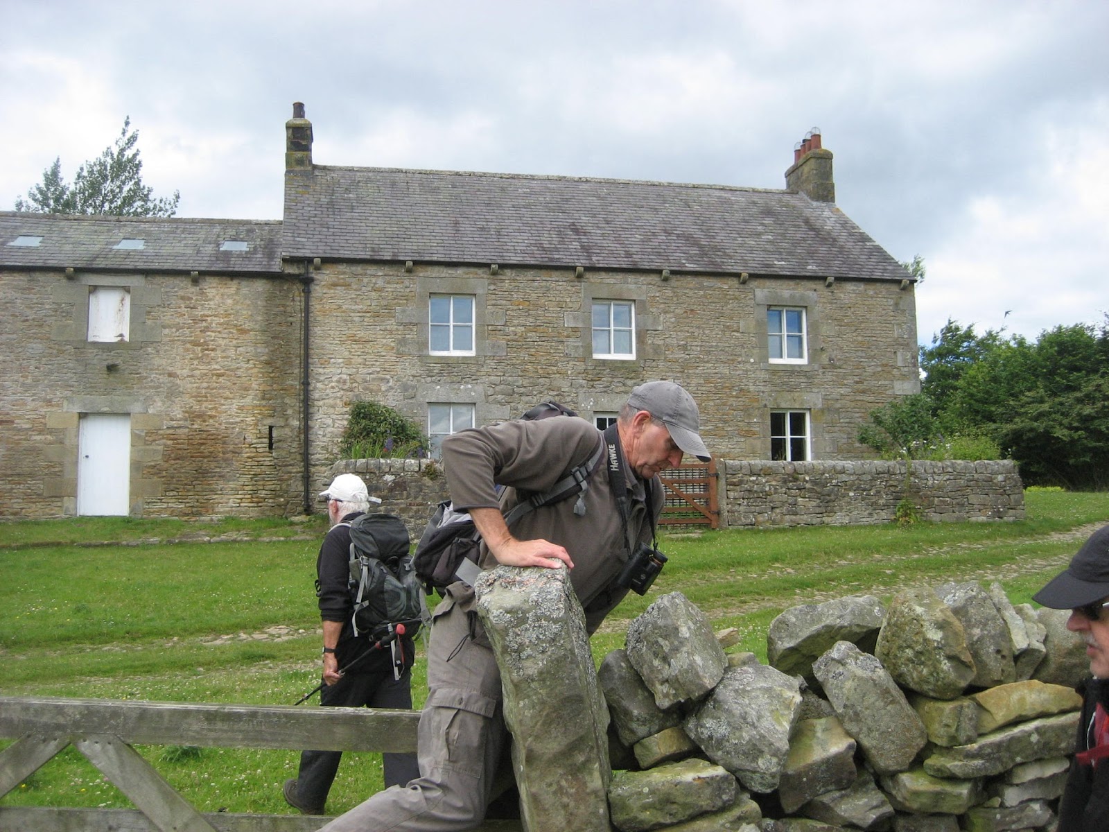
                    The bastle just across the road from the car park. A bastle is a fortified house, dating from the almost interminable border wars between England and Scotland. A peel tower is a mini castle
            Start the walk on the path between the information board and the car.
We set off up the path mentioned in the caption above. After a few hundred yards, if that, there is a footpath on the left that climbs steeply to a ladder stile. Over the stile there is a short scramble to the top of the rocky crags which once made an almost natural fort, look carefully and the outline can be seen. The footpath west from the fort is overgrown this time of year by heather but we plodded on, crossed the minor road and walked up to Ros Castle. Not much to see of a castle or settlement but the views are spectacular, the Cheviots  west, the north sea east and north looks down on Chillingham Castle. The famous Wild White Cattle live in the park  but today they must have been sheltering under the  trees.
               Another beautiful summer's day in Northumberland
         Descendent of the inventor of bergamot flavoured tea?
                  Chillingham Castle parklands, cattle free. The building left of centre is not the castle.
Having admired the views and chatted to a retired lady teacher also out walking we returned to the road and headed east towards Botany, passing a row of bee hives close to the road. (Normally on this walk we walk across the fields but, getting old, we decided they were a bit claggy. (Muddy)
After a little over  a mile, with the Eiffel Tower in plain sight, we spotted the sign post on the right that indicated the path to Blawearie.
                       Turn right before the Eiffel Tower.
Not too far along the track we turned left and headed south east along the path up Cateran Hill. Somewhere off the road is Cateran Hole, a natural fissure which tunnels some hundred yards into the hill side. It is difficult to spot, the moor was covered with heather which can make walking an effort, so on this occasion we gave it a miss. The hole was likely used as a hideaway in Riever days and possibly by smugglers too. Should you try to find it, take a torch.
  We walked over the moor, passing a touching memorial on the way.
          The memorial to Douglas Brown
                 This poem,the authorship is uncertain, was voted the favourite by the nation some years ago. Not theologically sound apparently, but often used at funerals.
Some way on from the memorial we called a Herbie Spot, sitting behind a wall to keep out of the chill July wind. Sadly no Mrs A today but we shared ginger biscuits from Ben, Snickers, Titans from ALDI and chocolate from Hungary. And I am still 175 lbs, or 12 stones 7 lbs in correct currency.
Lunch over we walked along the track before heading east just south of the trig point at spot height 215.
The footpath we took went along the wall to a ford and across a field to Harehope Farm.
                The stream looks brownish from the peat on the hills.
                              Harehope Farm
                                  Come chicks.
Heading north at the farm we crossed a large meadow, shaped like a hexagon on the map, before spotting a stile over barbed wire. The path from here initially crosses grass land before climbing over heather moors. Since our last visit there have been changes. There are now a  number of pens for young birds, grouse, pheasants, partridges, and paths have been cut through the bracken and heather, presumably for the shooters who will appear on the glorious 12th of August.
 The path brought us to Blawearie, an old farmhouse that was occupied until the 1930s(?) but is now a ruin. The name, apparently, means "tired of the wind".
                 Blawearie, lovely setting, shame nobody kept it as a home or farm.
               This pile of stones is possibly a burial cairn or cist, or possibly somebody having a joke.
Passing Blawearie we took the grass track on the right and headed north west over the moors.  Beautiful at this time of year, the heather being in bloom, the bees doing what bees do and small birds  flying out of the undergrowth as we approached. Finally we hit the road near Botany again, turned left and walked back to the car park.
                     Beehives near Ros Castle. The heather here has been burned off to promote new growth but there were acres of it for the insects to use for gathering nectar and spreading pollen.
Changed we drove down the A697 and called in at the Anglers Arms, as welcoming as ever. The pub had Hook Norton, "Hooky" on offer, Black Sheep and another ale.

Not having Dave the pedometer king with us the matrix is a bit short.

MATRIX MMXVII                         VVVVVVVVVVVVVVV
                                                                    steps                                   miles
NAK                                                           31359                                 9.89
iPhone                                                        26087 (big difference)       11.4
OUTDOOR GPS                                                                                   11
Ben's bragometer                                                                                   11


                        Contains OS data, copyright. Crown copyright and database right 2017


Saturday 22 July 2017

A pleasant stroll and a couple of pints. July 21st.
 And what's wrong with that?
Most of the gang are still away, some on the gentlemen's week in Scotland, some on family holidays.
John H., John Ha. and I have decided to have a shortish coastal walk from Blyth in Northumberland to Whitley Bay in the county of Tyne and Wear, an authority forced on us in 1974, the year they abolished Westmorland.
A very straightforward stroll, n o map required but should you insist there are two:
OS Explorer  325  Morpeth and Blyth and OS Explorer 316 Newcastle upon Tyne.
A linear walk but there are plenty of buses between the ends.
We met at Blyth bus station. I am very fond of the town of Blyth, I worked there for 27 years. Once a bustling mining and ship building town it declined in the 70s but is now on the up again, offshore work and industrial parks, plus a little coal exporting!
                 Blyth bus station, not a bus in sight. At least Blyth has a bus station which is more than can be said for nearby Cramlington, a bigger town. (Any Cramlington town councillor reading this take note)
From the bus station we walked east along Bridge Street, crossed over a roundabout and headed for the quayside. When I first came to Blyth the area was run down but things have improved considerably. The old coal staithes have been tidied up, new buildings have sprouted, including a hotel. And of course there is art work.
                                       Quayside art in Blyth. I don't know either.
Beyond the quay we passed Ridley Park which has some terrific rides for children, there were few there it being a school day and, yes, we were tempted to slide and swing.
After walking some distance along the road we turned left at a row of new houses and hit the promenade.
During WW2 Blyth was a submarine depot and the Blyth Battery, dating from both world wars is now a small museum.
                       Blyth Battery, a leftover from world wars.
Beyond the battery we decided to walk along the beach. (No dogs from May until September) The sand was soft and made for hard walking, even the damp strip on the edge of the incoming tide.
                 One of the piers at Blyth
And the long sandy beach heading south towards Seaton Sluice.
 The wind was from the south so we were walking into it. There were plenty of fellow walkers, most of them with dogs. When we reached Seaton Sluice we had no choice but to leave the beach and hit the road. A couple stopped us asking questions about the place. They were from Beverley (Yorkshire) but frequently stayed in the north east and, like most visitors, loved Northumberland. Between the three of us we managed a pretty good if concise history of Seaton Sluice, including a mention of Seaton Delaval Hall, designed bySir John Vanbrugh for the Delavals and built between 1718 and 1729.
                                        Seaton Delaval Hall, now a National Trust Property
The Delaval family, who came over with the conqueror, owned the area's coal mines and a glass works, now all gone. One head of the family had sluices built to scour the river, hence the name of Seaton Sluice. There is not much left to see of the gates but the cut which was dug to make entrance to the harbour easier is plain to see. Exports included coal, salt and glass.
                                        The cut at Seaton Sluice
                              Seaton Sluice harbour.
We took the cliff top road round Collywell Bay, the tide being too high to risk walking the beach, and then followed footpaths to St. Mary's Island where we called a Herbie Spot.
                  St. Mary's Island. You can walk over the causeway when the tide is out. There is a  cafĂ© and nature reserve.
This was the view from our Herbie Spot. We shared Snickers, Racers and some very tasty Hungarian milk chocolate that John Ha had brought back from Budapest.
Lunch over we continued our walk, taking the footpath overlooking the sea and watching out for flying golf balls from the adjacent pitch and put.
The promenade at Whitley Bay is being rebuilt making it necessary to stick to the footpath until we reached the famous Spanish City, another building being refurbished. Once, when Whitley Bay was a popular holiday resort, the domed building was a dance hall, part of it a cinema. Behind it there used to be a small fairground too.
                                  Spanish City
A little further on  we decided to call in at a small bar attached to "42", an establishment which had a micro brewery. Having sampled a beer called "Spanish City" we moved on to the Fire Station, once exactly that but now a Wetherspoons, always a good bet for good beer.
Then we went home, by bus, after a shortish but very enjoyable afternoon stroll.

A Mini matrix, not having the main pedometer man with us.
        NAK                                        21632 steps                                 6.82 miles
iPhone                                               17985                                         6.3
(Big difference in steps!)
                                   Contains OS data, copyright. Crown copyright and database right 2017


Saturday 15 July 2017

Swallows, Stonefolds and Sooks. (And they come in threes)(Northumberland)  July 14th.
  Reduced to four by holidays and family commitments, Dave, Brian, John H. and I are off for a walk on and near Hadrian's Wall.
Starting from Steel Rigg car park near the new information centre at Once/Twice Brewed, the walk heads east, turns north, then west and back to the car park.
From Newcastle, take the A69 west then the B6318 known locally as the military road, turn right up the lane at Once Brewed and the car park is just north of the wall itself.
The map to use is OS OL 43 Hadrians Wall and the car park is at NY751676 approx. (It also has lockers for bikes)
Breakfast was at Brockbushes garden centre/café/pick your own/farm shop on the roundabout for Corbridge. Tea/coffee/latte(?)/bacon sandwich and they have an old tractor like my uncle Clifford had.
                                        a proper tractor
Steel Rigg car park charges £4 for a day, which is reasonable. But the machine was broken so we joined other parkers by leaving notes attached to windscreens explaining we would love to have paid but malfunction prevented us. There were cars from several European countries making the most of open access before Brexit.
                         Steel Rigg car park.
From the car park we walked down to the wall.* This section is a "Clayton Wall", the land was bought in the 19th century by Mr Clayton who rebuilt some sections of the northern boundary of the empire, some 1400 years after the Romans went home.
The first two miles of the walk, along the wall, have several very steep but short ascents and descents, the first one right at the start.
 Looking down from Peel Crags on the  remains of a turret. This turret is an "extra" built at a weak spot, and does not have a number. The milecastles are numbered from east to west and the two turrets between them are numbered A and B eg 39A, the next one we came to.
 On one ascent we met an American, deep in conversation with an English couple, but he did say "Hi" as we past.
                          Milecastle 39, with visitors. We past several school parties walking this section. Nice to see them out, and they appeared to be enjoying it. Probably got a question session back in the coach.

After a mile we came to Crag Lough, a small lake, the wall runs on the ridge high above it. This is my all time favourite section of the wall.
                   Crag Lough from Steel Rigg
       Looking down on the Lough from the line of the wall
                         The lough through the trees.
I was by this time alone, John and Brian well ahead and Dave somewhere behind,  busy taking photographs. I chatted to an American lady enjoying a sandwich and the view. She explained that she was waiting for her husband who was way back, talking to somebody.
Further on on this section of the wall is "Sycamore Gap" where Kevin Costner shot a scene for Robin Hood, Prince of Thieves. Miraculously he had travelled from Dover beach to Hadrian's Wall in minutes.
                   The famous Sycamore and its gap. There were an awful lot of people walking the wall today, some out for a stroll, some doing the full length. (about 80 miles) Brian observed that some were Day Trippers and some were taking The Long and Winding Road.
Just after two miles, being an honest citizen, I took the diversion established to prevent erosion close to the wall, and also to avoid the steep descent on a rocky path. I heard Dave shout, turned and watched him waving to me. Because of the diversion I had missed the style  the where the Pennine Way ** crosses the wall. First mistake of the day.
Having crossed the wall I followed the footpath north east. For a major national trail this section is not of the best quality, meandering across fields. John and Brian were out of sight, somewhere ahead, I took a footpath east which actually leads to Broomlee Lough.  Looking back I noticed Dave had stuck to the Pennine Way, claiming the others were ahead. I turned back to join him, second mistake of the day.
Having battled through a small herd of curious cows with their calves we caught up with the other two and called a Herbie Spot, sitting behind a wall and enjoying the views, and the lunch.
                        View from the dining room. The hill on the right is Kings Crag and there are Roman inscriptions on the rocks there, supposedly. We have tried on previous occasions to find them.

                  This is a selfie, but taken in hope with my camera.  Worked well.  We shared Snickers, Scones from Mrs A., carrot cake and vegan fruit cake from www.jesmondcakecompany.com.
Lunch over we headed north across the fields, and still on the Pennine Way, to East Stonefolds farm. To get onto the farm track we had to climb over a very rickety gate. From here we followed the farm track south west to West Stonefolds farm. I had been carrying my walking poles, rifle like over my shoulder, but decided, just past the farm to use them. I noticed then that the lower section of one pole was missing. " Oh, Gosh" I exclaimed and set off back along the track to find it. I reckoned I would have caught it climbing the gate, I reckoned right too. The lengths some people go to to get in an extra half mile on a walk. This was mistake number three. It was generally agreed that Help, I need somebody to keep an eye on me.
The footpath goes along the edge of Greenlee Lough, part of which is a nature reserve and has no access. We did go into the bird hide on the north side of the lough but there wasn't much going on.
                 Greenlee Lough from the bird hide. According to the notebook left in the hide the area was dripping with birds. We saw a few ducks.
Back on the footpath we were pleased to see that a duck board walk had been built across the marshy ground near the water.. When we came to the end of it we headed north west uphill to meet a farm track, turned left and walked to Gibbs Hill farm (mile 6).
There are two footpaths from the farm, starting on the right side of the track. We took the right fork and walked west to Swallow Crags. Not very high but impressive enough and there were some swallows around.
                                                 Swallow Crags.
Near the end of the crags we found a path over them and down to Saughy Rigg farm, farm and B and B.  Up the track to the road, we turned right and walked to Well House.
                            Well House.
Just beyond Well House we spotted the sign post that said "Military Road 1.5 miles" and we tramped through long grass towards Windshields Crags

                 Windshields Crags. Part of the Whin Sill which is a tabular layer of the igneous rock dolerite. It crosses Northumberland, much of the wall is on it and at the North Sea end is the imposing Bamburgh Castle.
Once on the top of the crags we turned east and walked alongside the wall. We met an American lady, sitting enjoying the views. She said she was waiting for her husband who was way back, talking to somebody.......................
This is a farmer's wall, built on the broad base of the Roman Wall, using stones quarried by legionnaires. The regular shapes on the farmer's wall give it away. Some call it vandalism, some call it recycling.                                                                                                                             
Soon we were back at the car park, and noticed that the payment machine was now working. Too late.
Changed we drove down the track to the Twice Brewed pub on the B6318. The pub has been refurbished and has its own, new micro brewery which has just started working.
On offer were Pullet, Stanford, Pagan Queen and Twice Brewed Bitter.
Dave went to the bar and ordered drinks, only to return looking sheepish. He had no money. I think one no money equals three mistakes plus some more. As we enjoyed our beer an American couple walked in. He was still talking, but they had had a lovely day walking the wall.
Sooks? Name of a hill near Saughy Rigg

The Matrix MMXVII UUUUUUUUUUUUUUUU
                                                                       steps                                      miles
NAK                                                             30055                                     9.48
iPhone                                                           24860                                     11
Dave's 3D                                                     22198                                      9.77
  ""     USB                                                    21068                                     9.97
  ""          NAK                                              20697                                     9.79
OUTDOOR GPS                                                                                         10.35
Brian                                                                                                            10.2


Contains OS date, copyright. Crown copyright and database right 2017  
And mile markers are approximate      

* Hadrian' s Wall. Built on the orders of Emperor Hadrian and started in 122AD. It took four years to build, has several forts along the route, milecastle every Roman mile and two turrets between each milecastle. It marks the northern limit of the Roman Empire, is about 80 miles long and is a World Heritage Site.
** Pennine Way. Longest long distance path in the UK, starting in Derbyshire and finishing in Scotland, just. About 210 miles long.

Gallery