Oh Brian, where art thou? Sept.20th
After last week's walk in the Lake District we have opted for an easier local walk today. There are six of us out today, John, Harry, Ben, Brian, Dave and me. The walk is a variation of "Belford" from about two years ago and not surprisingly it starts in the small Northumbrian town of Belford which is easy to find. From Newcastle head north on the A1 until, beyond Alnwick, home of the Duke of Northumberland, and turn left at the signpost for Belford. There is a small café, The Well House, which serves a first class bacon sandwich in a choice of bun, with brown sauce if requested, and tea served in a willow pattern teapot and drunk from delicate cups with the same design. Everybody's granny had willow pattern tea sets!.
We left the cars outside the Belford Community Club at GR NU 106338. The walk is covered by OS Outdoor Leisure Map 340, Alnwick.
 Preparing in the park.
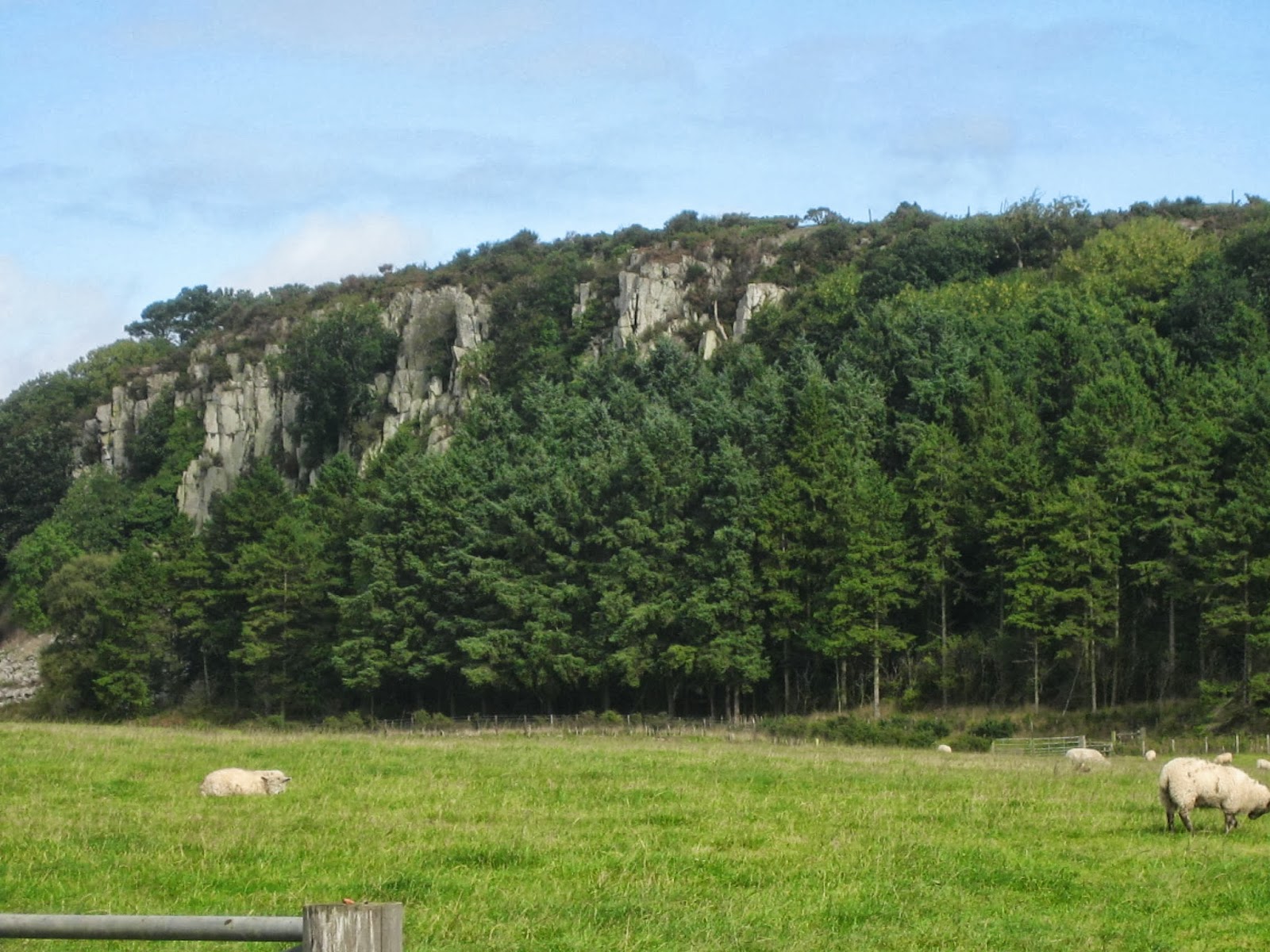
We took the lane on the left hand side of the club and walked towards Craggy Hall. This time of the year the hedgerows are full of blackberries, it is a good year for them , wet and warm. On the right hand side of the lane near Craggy Hall are some quite impressive crags, hence presumably, the name. Ben, who has an interest in geology, explained their formation and later even produced a geological map of the area. I should listen more carefully, then I could explain these extrusions. (1 mile)
After walking through a wooded area we came to a junction and realised Brian was no longer in sight, he had walked ahead from the start. Having done this walk before we knew he would have turned left and so did we, following the lane until we came to the farm at Swinhoe.
 Impressive crags
 And a lime kiln.
At Swinhoe we turned right and headed north west along the lane towards Swinhoe Lake. (2m)
 The swans of Swinhoe. Swinhoe means "swine hill" Belford,
surprisingly, may come from Bel-Haga Old English for
forest glade or dry land in a swamp.
 Gadgies in a glade. England in Autumn!
Leaving the woods around the lake we came across open ground (3m) which afforded a superb view towards the sea and Holy Island.
 My pocket camera is not good enough
for seascapes but this is Holy Island!
Soon we were back in woods again, Shiellow Wood to be precise but when we emerged into open land at Ravens Crag which gave us a panoramic view of the Cheviots we made a Herbie Stop (5m)although there was still no sign of Brian. A couple who were also having lunch said they had seen a man fitting his description striding out, sounded like Brian.
Fortunately I had remembered chocolate this week and we had Ben's superb home made ginger biscuits too. Lunch over we continued on our way over the grassy moorland. Should you follow this walk take the right fork near Holburn Moss, a small lake teeming with teal, and climb up to the ridge. A trig point (6m) tells you you are heading on the right direction.

But do stop to admire the Cheviots.
 Not so distant Cheviots
 Holburn Moss.
Not far from the trig. point we crossed a style, climbed the short distance to a cairn and followed a path across fields until we hit the woodland near Swinhoe Lake again. We retraced our steps to the farm (8m). At the farm we followed the sign post that led us past the riding school, across fields and back to Belford, the path being well marked with
 St. Oswald was here.
 Westhall, possibly a peel tower.
When we arrived back in Belford we noticed Brian's car had gone. And at that moment my phone informed me I had an email. It was from Brian, he had completed the walk by 2.30 and gone home as he had an evening appointment in a pub. He had however left us some of Mrs As home made chocolate digestives tucked into the door handle of Harry's car.
To finish the day we called in at The Salmon Inn in Belford which served Hadrian Brewery Coast to Coast. Four barrels because it was the only real ale, although it was in good nick!
Matrix MMMCV
steps miles
ASDAPED 17740 8.33
LIDL3D 10311 4.63 Failed again
DavesLIDL3D 20284 10.24 This is unfair
LIDLUSB 20184 10.19
OUTDOORGPS 9.72
Brian's GPS 10.2
Ben's bragometer 9.77
Bird of the blog
Has to be the teal, there were so many, although we also saw swallows, martins buzzards, pied wagtails swans and mallards.
 Beast of the blog, reported by Brian, a slow worm or legless lizard, and we've all been there.


After last week's walk in the Lake District we have opted for an easier local walk today. There are six of us out today, John, Harry, Ben, Brian, Dave and me. The walk is a variation of "Belford" from about two years ago and not surprisingly it starts in the small Northumbrian town of Belford which is easy to find. From Newcastle head north on the A1 until, beyond Alnwick, home of the Duke of Northumberland, and turn left at the signpost for Belford. There is a small café, The Well House, which serves a first class bacon sandwich in a choice of bun, with brown sauce if requested, and tea served in a willow pattern teapot and drunk from delicate cups with the same design. Everybody's granny had willow pattern tea sets!.
We left the cars outside the Belford Community Club at GR NU 106338. The walk is covered by OS Outdoor Leisure Map 340, Alnwick.

We took the lane on the left hand side of the club and walked towards Craggy Hall. This time of the year the hedgerows are full of blackberries, it is a good year for them , wet and warm. On the right hand side of the lane near Craggy Hall are some quite impressive crags, hence presumably, the name. Ben, who has an interest in geology, explained their formation and later even produced a geological map of the area. I should listen more carefully, then I could explain these extrusions. (1 mile)
After walking through a wooded area we came to a junction and realised Brian was no longer in sight, he had walked ahead from the start. Having done this walk before we knew he would have turned left and so did we, following the lane until we came to the farm at Swinhoe.

At Swinhoe we turned right and headed north west along the lane towards Swinhoe Lake. (2m)

surprisingly, may come from Bel-Haga Old English for
forest glade or dry land in a swamp.

Leaving the woods around the lake we came across open ground (3m) which afforded a superb view towards the sea and Holy Island.

for seascapes but this is Holy Island!
Soon we were back in woods again, Shiellow Wood to be precise but when we emerged into open land at Ravens Crag which gave us a panoramic view of the Cheviots we made a Herbie Stop (5m)although there was still no sign of Brian. A couple who were also having lunch said they had seen a man fitting his description striding out, sounded like Brian.
Fortunately I had remembered chocolate this week and we had Ben's superb home made ginger biscuits too. Lunch over we continued on our way over the grassy moorland. Should you follow this walk take the right fork near Holburn Moss, a small lake teeming with teal, and climb up to the ridge. A trig point (6m) tells you you are heading on the right direction.
But do stop to admire the Cheviots.


Not far from the trig. point we crossed a style, climbed the short distance to a cairn and followed a path across fields until we hit the woodland near Swinhoe Lake again. We retraced our steps to the farm (8m). At the farm we followed the sign post that led us past the riding school, across fields and back to Belford, the path being well marked with


When we arrived back in Belford we noticed Brian's car had gone. And at that moment my phone informed me I had an email. It was from Brian, he had completed the walk by 2.30 and gone home as he had an evening appointment in a pub. He had however left us some of Mrs As home made chocolate digestives tucked into the door handle of Harry's car.
To finish the day we called in at The Salmon Inn in Belford which served Hadrian Brewery Coast to Coast. Four barrels because it was the only real ale, although it was in good nick!
Matrix MMMCV
steps miles
ASDAPED 17740 8.33
LIDL3D 10311 4.63 Failed again
DavesLIDL3D 20284 10.24 This is unfair
LIDLUSB 20184 10.19
OUTDOORGPS 9.72
Brian's GPS 10.2
Ben's bragometer 9.77
Bird of the blog
Has to be the teal, there were so many, although we also saw swallows, martins buzzards, pied wagtails swans and mallards.


