The Herriot Way
A second long walk for the year. Five of us following a trail round the Yorkshire Dales in the area where James Herriot carried out his veterinary practice and wrote his tales. Made into a TV series in the 70s, All Creatures Great and Small, and again in 2020, his jolly tales of Yorkshire farmers and their animals were rightly popular. There was a film too.
We are starting and finishing the circular walk in Aysgarth. The walk is covered by OSOL 30, The Yorkshire Dales North and Central.
There is also a detailed guide book, Walking the Herriot Way, by Stuart Greig. Full of notes on the villages the walk passes through and a link to a site for detailed maps for the whole journey.
First night in Cornlee Guest house, Aysgarth, dinner and beer in The George and Dragon.
After breakfast (feast) served by Jason we set off for Hawes. Please note this is not a guide, just a report on the walk we did. And also note the Herriot Way is not posted like the Pennine Way although it makes use of public footpaths, the PW and the Lady Anne Way in places.
Day 1 Aysgarth to Hawes
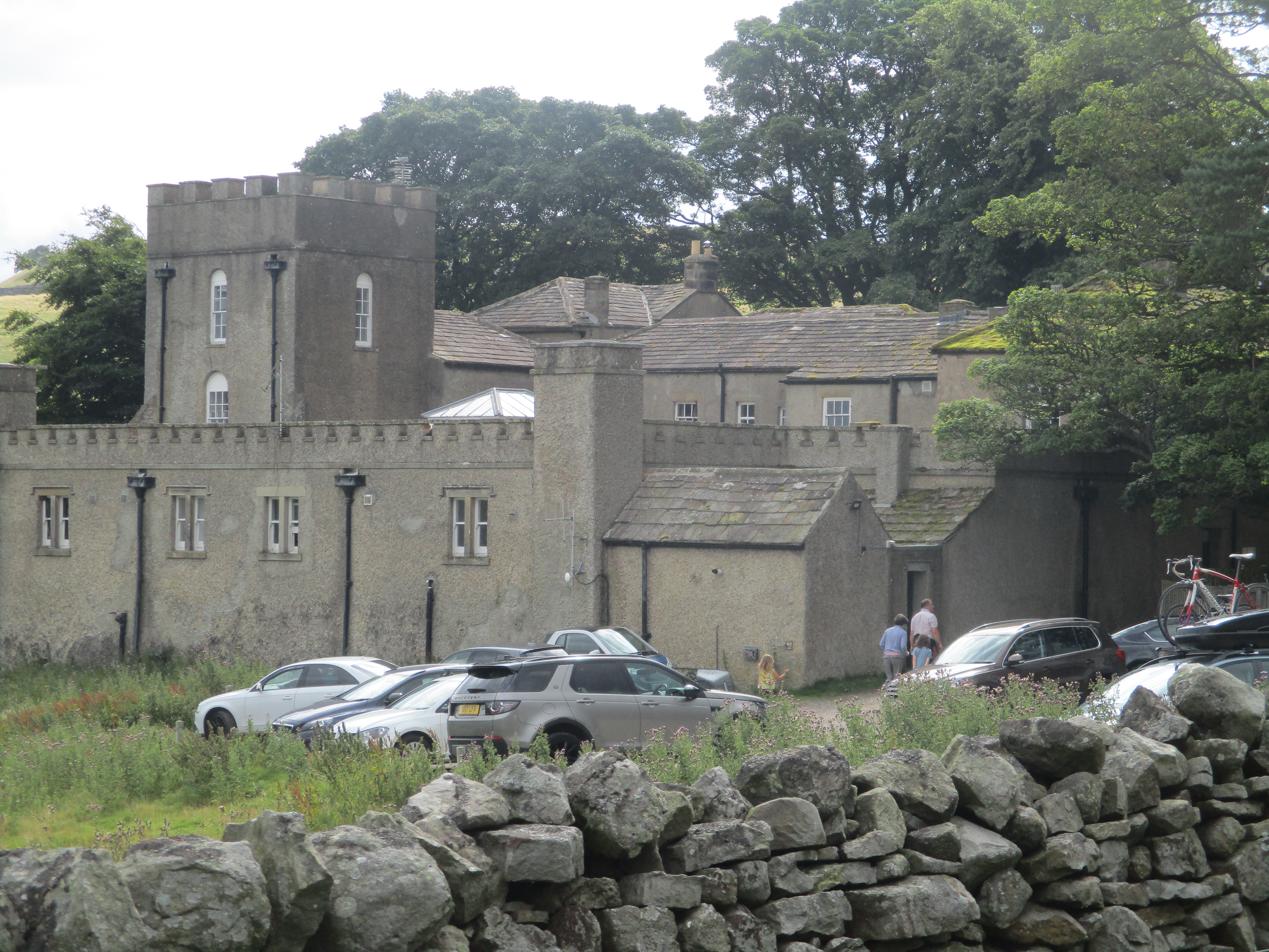
In a tradition going back several hundred blogs here is a car park:
Not one for the calendar. Cornlee House is behind the two cars. The start of the Herriot Way is between the houses on the left, opposite Cornlee.
The walk starts through a gate between two of the houses and a path leads downhill across fields to the River Ure. We turned left, crossed fields, walked through woodland and came across the first of several hundred gated stiles.
Fine example of a gated stile. They nearly all have a strong spring with a tendency to smack you on the backside. The gap in the wall is usually fairly narrow too.
Soonwe came to a footbridge, crossed to the north bank and continued through fields until we joined the dismantled railway. Told by a notice to leave the railbed we were back in fields and making our way to Askrigg where we stopped for morning coffee.
This house was used in the original All Creatures Great and Small. Looks like they left the car St Oswald's Askrigg. Pevsner claims it has one of the finest roofs in Yorkshire.
Break over we walked on past the north side of the church and were soon back in the land of fields and gates and stiles. (I'm told there is a book of walks in Yorkshire without gates, must find it.) Aftere many a field we reached the village of Sedbusk to be greeted by a shower. Carrying on we reached Simonstone Hall, now a hotel, and walked down hill to Hardraw.
Simonstone Hall.In Hardraw there is a fine looking country pub, the Green Dragon which sells the sacred brew from Keighley. Sadly it was closed so we crossed more fields to Hawes, capital of the Dales and went to our next residence Wensleydale House run by a lovely couple, Wayne and Shelagh, (really called Jan) both from Australia.
The Green Dragon at Hardraw.Hawes is famous for the cheese made in the area, Wensleydale of course, but it also has a connection with a famous British series of animated tales about Wallis and Grommit, a pair who have adventures highly suitable for all ages.
Wensleydale House Shaun the Sheep Wallis and Grommit outside the Crown Hotel.
We had dinner at the Crown and also visited the Broad pub and the White Hart.
Distance for day 1 12.2 miles
Day 2, Hawes to Muker
Leaving Hawes we headed west, took the right fork and left the road on the left to cross fields (and gates) towards Appersett. Going under the Appersett Viaduct and alongside the Widdale Beck (Note the word beck, we're in Yorkshire)
Beyond Appersett we, at a road junction, spotted a finger post and climbed uphill to join the Pennine Way. At this point the PW is a gravelled farm track that climbs steadily but relentlessly to the summit of Great Shunner Fell which is the third highest mountain in Yorkshire. When track runs out the footpath, which is well cairned, heads north. In places, to prevent erosion and to make life easier in boggy peat, the path has been paved.
Some purists object to the paving but they are better than ploughing throgh peat bogs. The slabs come from demolished mills in Lancashire and Yorkshire, Some have holes drilled in them for machinery. Some my family may have trod.
At the summit is a cross shaped shelter and had it been a clear day there would have been stunniong views as far as Pen y Ghent or Ingleborough.
The handsome crew on Great Shunner Fell. (Photo from Brimar pictures)
Having lunched we set off down the hill on a path that was also paved in places. Eventually it morphed into a gravel track and finally joined a road. Turning right we were soon in the village of Thwaite which had a tea shop!
Canny little bridge outside ThwaiteThwaite, with tea shop. We stayed here on the Lady Anne Way.After a few more fields (and gates) we were in Muker, home for the night.
Stoneleigh House, run by Dave and Sheila, another top class BnB.
We had dinner, and some refreshing beer in The Farmer's Arms, the only pub in Muker, run by an eccentric individual but the food was worthy of a column in The Times.
Day 2 distance 11.2 miles Running total 23.4
Day 3, Muker to Reeth
After Dave and Sheila's tasty breakfast we left Muker and headed north out of the village and climbed over the nearest hill to the village of Keld. Leaving this beauty spot we took a downhill path, crossed the infant Swale and walked narrow paths, vaguely East until we reached Crackpot Hall, a ruined farmhouse.
One of several along the way.
Beyond Crackpot Hall we passed the remains of the old lead mines. But we also seemed to lose our way.
Two of the team carried on almost without path, the other three decided to fight though the bracken to the track in the valley below. We met up again near a footbridge and had a reunion lunch. Amazingly we were about a mile from Muker, the day's starting point.
Bridge on the Swale.
Pushing on we went through fields to Ivelet and a little later on we discovered a pub in Gunnerside. We needed liquid.
Joining a riverside path we continued on our way, at one point having to cross, carefully a patch of ground that was swarming with miner bees. Never seen so many. At the village of Healaugh we joined the road and decided, as we were pushed for time, to stay on it and walk to Reeth. We found the Black Bull, home for the night and after a quick shower had dinner and Timothy Taylor's Landlord.
Day 3
Black faced sheep Black Bull, ReethDay 3 distance 15.8 miles Running Total 39.2
Day 4 Reeth to Aysgarth
Fed and watered we left Reeth and walked across fields until we reached Grinton Youth Hostel.
Grinton Lodge, once a shooting lodge, now a youth hostel'Almost directly across the road from Grinton we found the beginning of the long trek across the moors.
Walking in almost a semi circle high above the Swale Valley to start with we passed several mining sites. At one point we had the first real rain of the walk but fortunately there was a shooters hut nearby, kindly left unlocked so we sheltered. Interestingly it had two rooms, one with fine tables and chairs, a fireplace and logs. The other with benches and old tables. Guns and beaters ? Class system?
Regardless, when the rain stopped we started again and continued on our way on gravelled tracks until we came to a desolate building, turned right and headed over a hill.
A desolate building, reminds me of Broadstruther.
From the top of the hill the downward path was grassy and easy going after the hard tracks, We were soon in Castle Bolton a village with a fine castle; Bolton Castle.
Bolton Castle
From the castle we followed a narrow footpath that brought us to a road. We turned left and after a few hundred yards went field walking again, eventually joining a grassy track that took us to Aysgarth Falls.
Aysgarth Falls (Brimar pictures)
Beyond the falls we joined a road that climbed out of the valley and back to Aysgarth village again and Cornlee, run by Jason.
Showered we went to the George and Dragon for a celebration and dinner.
Day 4
All maps: Contain OS data copyright. Crown copyright and database right 2023
Distance for day 14.8 miles Total distance 54 miles.
And a few more