Translate

Saturday 31 October 2015

Beach Boys.........October 30th(Northumberland coast)
   If you read this regularly you must realise we gadgies get around.  The forecast for today is poor, good chance of showers and a strong breeze so we are having an easy walk up the coast of Northumberland, admiring the long stretches of golden sands, the background of hills and maybe the world record holding field for wheat production.  It's on the mainland,  opposite Holy Island.Wouldn't it be nice to have a sunny autumn day but we'll have fun fun fun. The plan was to start from Alnmouth and walk up the Nothumberland Coast Path/St. Oswald's Way to Seahouses, a distance of about 13 miles, but flat. (St. Oswald again, last week we were on his way near Rothbury, he certainly gets around).
 As it was raining heavily when we left home it was agreed that coffee in Alnwick would be a good idea so we headed for Barter Books. This establishment is in the old Alnwick Railway station and contains thousands of books, fiction and non fiction, CDs and DVDs.                                                                  Have a look at it on www.barterbooks.co.uk, and should you be in the Duke's town pay a visit. It is difficult to leave without buying. It also has a buffet, far better than anything British Rail ever offered so after tea or coffee we worked round the book shelves before setting off again. As time had passed we decided to cut the walk short and headed for Craster on the coast. To get there from Newcastle take the A1 north and just beyond Alnwick turn off for Denwick and follow signs until you find Craster. It has an information centre and car park (Paid) just as you enter the village.
It is possible to do this walk without a map as it follows the coast and is quite well marked, but for OS fans it is covered by two maps: 
OS Explorer 332 Alnwick and Amble
OS Explorer 340 Holy Island and Bamburgh.
The car park is at NU256197, and here it is.
               Wet day in Craster, not many folks about. (Craster means the camp where crows live)
    As predicted by the BBC, working with the meteorological office, by noon the rain had ceased, but we donned waterproofs and set off. 
From the car park we walked down to the harbour, and headed north on the footpath to Dunstanburgh Castle.
                                    Craster Harbour, nearly empty and very muddy.
  The path to the castle crosses several fields and it is a popular walk. As it was half term there were lots of family groups plodding the muddy track to the castle and back, small children quite excited, teenagers glued to their mobile phones, texting friends about the misery of being out with parents. Nothing changes.
                                Ruined Dunstanburgh. Built by the Earl of Lancaster whose family were later made Dukes, John of Gaunt being one of them. The title passed to the sovereign so rather oddly HM Elizabeth II is also Duke of Lancaster. Lancastrians are permitted to toast the Duke rather than the queen, so they say but Lancastrians say anything.
  Beyond the castle the path crosses the golf course. You have a choice, take the footpath on the dunes or go down and walk the curve of Embleton Beach, for a change we took the dunes path to avoid scrambling over boulders and to avoid dog walkers and children toughing it out on the wet sand.
Low Newton by the Sea is a square of whitewashed fishermen's cottages and a pub which is frequently recommended by The Times when their writers venture out of the Home Counties. There are a couple of bird hides along a path behind the square. A poor day for the birders, too miserable, but we saw sanderlings and ringed plovers.
  There are some benches looking back at the bay, they made an excellent Herbie Spot. Today's fattening treats were fruit cake, ginger biscuits, almond slices and flapjacks from a small but classy cake maker in Newcastle upon Tyne. See their cakes at  www.cakepoppins.co.uk.
The local sparrows were friendly and accepted our crumbs.

                                           Spuggies at Low Newton.

Low Newton by the Sea, photo not taken today as you can probably tell. The pub is in the right corner.
 Fed and watered we walked a short way up the road, (there is only one) and through the gate on the right to rejoin St. Oswald. We descended to the beach and walked round Beadnell Bay. At one point a stream with the delightful name of Long Nanny enters the sea. At low tide it is possible to walk across the stream but not today we walked a hundred yards or so inland and crossed the stream by means of a footbridge before returning to the beach and striding on to Beadnell, another fishing village. This bay is also a popular dog and child walking place, there were a couple of surfers out too, Surfing Girl was skillful, Surfing Boy kept falling off.

                               Long Nanny is the stream on the right, the one on the left is Brunton Burn.
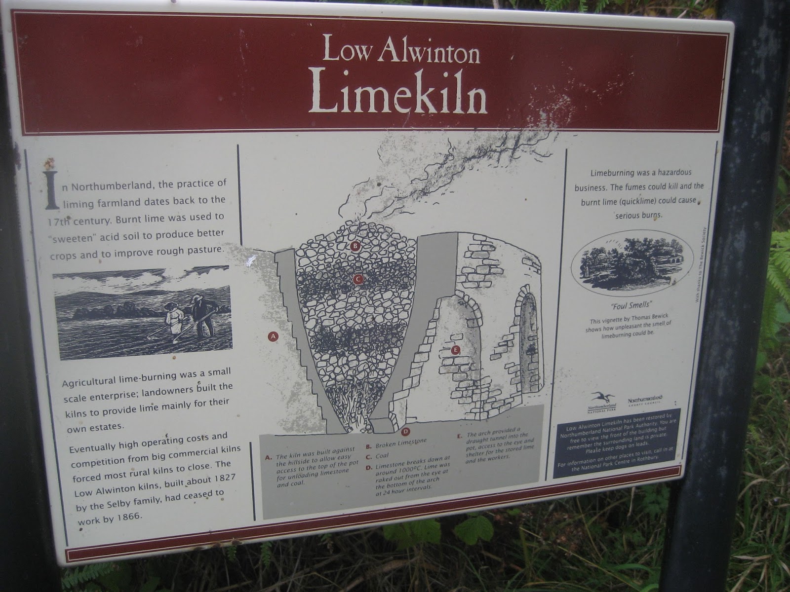
Beadnell has some fine Limekilns. They were used to make fertiliser by cooking limestone with coal.
                                                 Beadnell Limekilns, wonderful stone constructions
                                             Recipe book for lime.
                     Beadnell Harbour, with dunes across the bay.
We walked through the village, many of the houses seem to be holiday lets and the season is almost over. North of the village we descended to the beach again and headed for Seahouses. Usually we cross the stream and walk over Seahouses Golf Course but today because of the high tide we headed a short distance inland and finished the walk on the road.
From the centre of the village which has several tempting fish and chip shops, we caught a bus back to Craster, changed and headed for Grey's Inn in Embleton. It was packed with families enjoying a last meal before the end of the holiday week so we headed south on the A1 and went to Wetherspoons in Morpeth for a drink, Zulu Blonde in my case, strange name but a good way to celebrate another gadgie walk God only knows why we do it.

The Matrix MMXV  WW

                                                                   steps                                  miles

All new Nakosite                                     29827                                 12.58
LIDL3D went mad
Dave's LIDL3D                                      22358                                   10.28
Dave's USB                                            22010                                   10.07
OUTDOOR GPS                                                                                 10.93
Ben's bragometer                                                                                 11.0


All three maps. Contain OS data Cpoyright. Crown copyright qand Database right 2015

Saturday 24 October 2015

Gusset and Bushygap a tour of Northumberland Farms...................Oct 23rd.
  Believe it or not, these are two places on today's walk which is centred on Rothbury in Northumberland. To get there from base head North on the A1 take the A697 north of Morpeth and bwatch out for diversion signs for Rothbury as the road has still not been repaired.
There are six of us gadgies out today, Brian, John H, Dave, Ben, Harry and me. Two cars so we are meeting in Tomlinsons  cafe and bunkhouse on Bridge Street a cafe that serves good bacon sandwiches and is generous with its tea.
We left the cars on the road outside the cafe, booted up and set off.

Tomlinsons cafe and bunkhouse in Rothbury. See later photo for the bikes. It is today's car park too.
  We started off by crossing the recently repaired and strengthened bridge across the Coquet and turned left along Mill Lane to join St. Oswald's Way, a long distance Northumbrian walk. If you look at the map and have slightly more than half a brain you can see that St. Oswald's follows the disused and dismantled railway line/ for a while but if you are six gadgies who refrain from reading OS publications at times you will decide to turn down to the river,walk through fields and woodlands with thigh high bracken and nettles.(There is a footpath marked this way on the map)

Cottage or barn that has seen better days. 
                  However we were soon back on track, some way beyond Wagtail Farm. The way then leaves the railway and crosses fields before reaching West Raw. Beware, as we approached this farm a recording announced we were being recorded on CCTV, the message being repeated several times.  From this protected farm we followed the farm road past Butterknowes to East Raw. (Just after mile 3).

                                      Watch out for this sign post at East Raw and follow it.
The above sign sent us across a field and into Forest Burn. This wooded burn is a bit of a challenge. The path criss crosses the stream several times and apart from at the beginning there are no footbridges. The water today was not very deep but the moss covered stones were slippy and progress was slow until we emerged at  a ford close to The Lee.
I am very fond of this farm. In 1986 I was out on my bike, alone and approaching the ford downhill from Rothbury on my way home. I decided to go through the ford, it was summer and it didn't look deep. The next thing I knew I was over the handle bars in the water with what I first thought was a mouthful of broken teeth. It was gravel. There was an unseen pothole in the water.
 My front wheel was badly buckled, my watch was broken and I had 2p in my pocket. Fortunately the rest of me was fine. I knew there was a phone at nearby Embleton Terrace so thought I might as well head that way. As i past The Lee farm I decided to ask for help and knocked on the door. The farmer was watching the European Cup Final but he took me in, gave me a glass of brandy and said he would take me home after the match. His wife came in from shopping and insisted I change my wet trousers for a pair of her husband's. Match over he took me and my bike home, refusing any money for petrol. Next day I returned with a thank you gift and I took my girls along for the ride. My younger daughter was about ten and keen to be a vet. The farmer took her round his farm showing off his sheepdogs and some of his flock. What a man, we need more people like that.
I was in the area a few weeks later, the potholes had been patched!!!
                                              Autumn in Forest Burn

                                        The ford at The Lee, greatly improved!
(Had we turned left up the road at The Lee we would have come to the Gusset)
Reminiscence over we crossed the stream by the bridge and headed across a field with two dilapidated caravans, climbed the bank and followed the footpath across fields to The Lonning. From here we followed a farm track which crossed the old railway, still with its LNER gate, to the road, turned left and almost immediately turned right down another farm track to Blagdonburn Farm. The footpath goes through the farmyard  and then heads north west across moorland in the direction of Spylaw. Along the way we sheltered from the breeze behind the wall of a Sheepfold, or Stell as they are called in the north east, for a Herbie Spot.
                                                 Full of cake and biscuit
Sheepfold or Stell
                                                                                   Thankfully Mrs A has returned so we shared her fruit cake plus ginger biscuits from Ben, Cherry Bakewells, flapjacks and Alpine Bars. But we walk it off.
Lunch over we continued towards Spylaw, rejoined the St. Oswald's Way footpath  and headed down a flagstoned path to cross the road just north of Lordenshaw. There is a car park here. The path continues north east but at the first junction we left St. O's and walked across Garleigh Moor, ignoring the remains of the Iron Age Fort, various cairns and a standing stone before hitting the road near Whitton Farm. The road goes past Sharp's Folly:

Sharp's Folly and plaque. (Whitton and Tosson Parish Councils)
At the foot of the hill, across the road from Whitton Towers is a marked gate. The footpath crosses two fields and then emerges in the town near the bridge and the cars.
The tour of Britain Cycle Race passed through Northumberland earlier this year. The route was marked by old bikes painted red and gold, the county colours, these have been left.
It was a good day for the birders too. We saw two herons, guaranteeing a good gadgie walk, nuthatch, dipper, kestrel, buzzards and the bird of the blog is a snipe, we saw several.
Snipe

                                     River Coquet at Rothbury.
Changed we headed for the Anglers Arms at Weldon Bridge. They had Timothy Taylor's Landlord, Abbott and Speckled Hen on offer, plus some really nice coffee.

The Matrix MMXV WW
                                                                         steps                             miles
LIDL3D                                                           28377                            9.22
OUTDOOR GPS                                                                                   10.99
etrex                                                                                                       11
Ben's bragometer                                                                                   10.85
Dave's LIDL3D                                               24645                             10.84
Dav'e USB                                                      24053                             10.62

If my mum had not died in March she would have been 100 today. She would have been pleased with the Queen's telegram but would never have agreed to a paragraph in the local paper giving reasons for longevity. But as daughter Lucy said "Well 99 is pretty good and it's a nice ice cream. Just like grandma always had."

Wednesday 21 October 2015

A clockwise walk from Bolam Lake.. Oct 20th. (Northumberland)
  An extra mid week walk again for Dave and I, more or less reversing a walk done a few weeks ago and spending a little more time looking at archaeological sites.
 The local weather forecast lived up to its promise, a sunny day with a light breeze, a late Indian summer, it is after all well through October.
We are walking from Bolam Lake country park, north west of Newcastle. To get to the start negotiate the road works at Cowgate, head up the A696 past the airport and through Ponteland of happy memory. Just beyond Belsay bear right and after a couple of miles find the car park and information centre at Bolam Lake country park. There are two other car parks but since April 1st they have all been free, good Yorkshire Scottish  car parks. A map is useful OS OL42 Kielder Water and Forest covers the walk.
                       This week's car park at Bolam Lake, info centre  top right, but it was closed!

                                          Lake and autumnal woodland.
  We walked down to the footpath by the edge of the lake, disturbing a heron and thus making a real gadgie walk, and turned left, following the path to the corner of the park which is the junction of the roads at Bolam Low House. Choosing the road back to Belsay we walked for a couple of hundred yards before spotting the sign at the " white gate" which directed us across a couple of fields to Shortflat Tower (printed in gothic on the OS map, must be old). At the farm buildings here we took the right hand track, across a footbridge and past a field with what appeared to be cardboard cut out sheep and rabbits, towards Sandyford.
Sandyford is a symmetrical farm:
               Sandyford: is it two farms, maybe squabbling brothers, father's way of sharing his estate?
The road past Sandyford is a metalled farm track, beyond West Tofthill we looked out for and found, the signpost  pointing almost due north to East Shaftoe Hall. (Just after mile 2) This footpath across fields crosses The Devil's Causeway, the course of a Roman road. Although there is nothing much to see it is possible to pick out the line of the road as it crosses the field diagonally. But we did see a flock of redwings.
 East Shaftoe Hall is a grade 1 listed building, the west end is a pele tower dating back to the 13th century. Just as interesting is the magnificent walled garden in front of the hall.
                          East Shaftoe Hall and walled garden. Immediately in front of the hall it is
possible to make out the outlines of a medieval village.
  Turning left at the hall we followed the well made track to Shaftoe Crags, an area of sandstone outcrops topped by the Devil's Punchbowl. Allegedly W Blackett of nearby Wallington Hall had the punch bowl filled with several gallons of wine at his wedding feast.
       Dave on the Devil's Punchbowl, singing I am an island, I am a rock.
                                           The punchbowl on top of the rock.
I have to admit I found it quite difficult climbing to the top of the rock. As we stood admiring the view a group of about a dozen gadgies and gadgettes approached, they were on a guided tour, their guide gave a talk on the formation of sandstone beds and explained why some layers are at angles to others. Retired Geography teacher. Anyway I asked the ladies to disperse so they wouldn't see me make a fool of myself descending, and they did.
Just by the sandstone outcrops there are the remains of an iron age fort, the ramparts and ditches still visible although covered with bracken. A good site for a fort, to the south are cliffs.

                      Ramparts and ditches at the iron age fort.
 Following the track past Shaftoe Grange we same to Salters'Nick, a gap in the sandstone once used by smugglers taking salt to Scotland or smugglers bringing whiskey to England. The cuts made by wagons are still visible.


 Rutted by smugglers of salt and whiskey. deep ruts the wagons made, Both the victors and the losers came by here

                                                       Salters' Nick
Layers of sandstone, washed down and laid in the sea. Note how some layers are at an angle and find out why for this week's assignment.
Once through the nick we scrambled down the low cliffs, watched a young man practise his rock climbing skills and found the "cave" where mesolithic artifacts had been found indicating its use as a flint factory.
It was so warm we settled with backs to the wall for lunch, treats today: tracker bars and brunch bars.
Lunch over we headed back up the cliffs and searched for Victorias Jubilee post in a field off the track. It looks like an unwanted gatepost.
                                                  Erected for Victoria's Jubilee, 1887
(Our wanderings explain the squiggles on the map)
 We walked east down the track before spotting the marker that directed us across a cow (and bull) filled field to the farm at Middleton Bank Top. We turned right on the road  and almost immediately followed the marker on the left and headed almost due east to Bickerton crossing the Devil's Causeway for a second time although again it is not really visible. A combine harvester was cutting down a crop of what looks like beans, shredding them and spewing them out behind to be used as a fertiliser.
John Deere and Massey Ferguson. " I got a brand new combine harvester" as the Worzels sang.
At Bickerton a flock of guinea fowl  dispersed as we approached. The man of the house said they had poor mothering skills!

                    Guinea fowl seeking safety and protection.
We followed the path beyond Bickerton and turned left at the next road and headed for Angerton Station. The station, now a house, is on the dismantled Wansbeck Railway Line and is not a right of way but we are gadgies prepared to risk an ASBO and followed the line for a short way before turning right across fields passing Angerton Steads and following the new route across fields on the north side of Bolam Hall to a fine stile.
                                                 A stile with style

Information by the stile. 
Once over the stile we turned left down the road and took a short short cut through the wood back to the car park. The information centre was still closed. No drink either(Quiz night in the pub)  we went home

The Matrix MMXV      XX
                                                                             steps                            miles
 LIDL 3D                                                            28133                            9.16
Dave's LIDL3D                                                  23194                             10.2
Dave's USB                                                        22273                              9.84
etrex                                                                                                           10.85
OUTDOOR GPS                                                                                       9.8


Friday 16 October 2015

Старbiе роокландс  ....Октябра 16(Northumberland)
For some reason I have had a lot of Russian readers lately, or one Russian lots of times or....
The dreaded cold or virus has hit the gadgies hard this week and there are only four of us out walking. For several reasons we have chosen a walk near base, from Alwinton beyond Rothbury, to the deserted farmhouse Old Rooklands. To get to Alwinton, another pretty Northumbrian village with a pub, from Newcastle; A1 north, A697 at Morpeth and follow the diversion signs for Rothbury. (The road is still under repair) Go through Rothbury and turn right at the signpost for Alwinton. On the edge of the village there is a grassed area for parking.
 The team today consists of Ray, John H., Dave and me. A map is useful, OS OL 16 The Cheviot Hills  and the parking area is at    NT922064, approximately.
The forecast is promising, easterly breezes coming all the way from Russia, but not bringing too much cold air, enough for that extra layer as winter approaches.
 The Rose and Thistle Public House in Alwinton, it has a nice garden round the back for warm days.
                                                          Alwinton free car park. There is one further down past the pub belonging to the National Park but it is not for Yorkshiremen or Scots.

Next to the car park is a stream, the River Alwin and the walk starts by crossing the footbridge and going uphill on Clennel Street, which is not built up like a street in a town. Clennel Street is an ancient trackway joining Kelso in Scotland to Morpeth in England. Its old name was Ermspeth, Anglo Saxon for "Eagles path", not that there's any eagles about now. Mostly these tracks were used by drovers taking their herds to market in England, now they are used by walkers, mountain bikers and sometimes by motor cyclists. Keeping to the "street" we walked steadily uphill with the fort on Castle Hills on our left, yet another bronze age settlement. After a mile the street goes off to the left, the path we took heads almost directly north. One problem is the increasing use of quad bikes which have created more paths. Ours crosses a "Cross Dyke", an obvious and ancient construction like a boundary wall, but according to our pet archaeologist it was designed to hold horses back.
                                There is a fort on this hill, honest.
 Reaching the crest of the hill we could see that much of the plantation clearly visible two years ago had been cleared, leaving ugly stumps and scrap timber. We headed down to a stile (mile 2) and turned through almost a semi circle to walk along the valley of the River Alwin, disturbing a heron as we walked. After about a half mile, and having crossed the river we turned east up Rooklands Sike. (Yet another word for a small stream, particularly one that dries up in summer)
We climbed steadily through high and wet bracken, disturbing another heron,  and further more it started to rain. We watched out for ticks,  Lime disease is on the increase. Eventually we came to Old Rooklands, the tumbledown farmstead that serves as a Herbie Spot.
                                   It's not much but it serves as a Herbie Spot. Today's offerings were ginger and chocolate biscuits, flapjacks and Mr Kipling's Cherry Tarts. Mrs A comes home this week.

                                         For the ladies of Forest Hall and Goole
Lunch and rain over we continued east along the track which turned south east and eventually came to a minor road. We turned right and almost immediately followed the road as it turned left.After a few hundred yards a signpost on the right directed us diagonally across a field and we emerged on another minor road which took us past the farm at Newton. Quite a large establishment with a farm shop and what seem to be several holiday lets. Just after the farm a signpost on the left sent us across three fields,  and along the side of a narrow plantation. (6). Take care if you follow this, the path is marked but is down in a hollow, difficult to spot. Heading south across a couple more fields we came to the farm at Well House.
                                Grey day in the Cheviot Hills.
From Well House a farm road goes downhill. In spring the verges are covered with daffodils, but this is October, plant life is falling back. At the Peels (7)  we followed The Border  County Ride which in places is a muddy track, and all year round too. It passes a fine example of a Lime Kiln.(Nothing to do with disease.) The county is dotted with them, they were once used to make lime for the fields.


Instruction book for the lime kiln at Low Alwinton.
We passed close to a holiday let which had some fine looking cabins, St. Michael and all Angels church and soon found ourselves back in Alwinton.
St. Michael's. Parts date back to the 12th century but most is 19th century rebuilding.
 On the way home we stopped at the dear old Anglers Arms at Weldon Bridge. As welcoming as ever it offered Speckled Hen, Taylor's Golden Best and Courage Directors. All in good condition.

The Matrix MMXV  VV
                                                              steps                              miles
LIDL3D                                                   22923                           6.94  (Little legs)
etrex                                                                                              9.08
OUTDOORGPS                                                                           8.82
Dave's LIDL3D                                        20432                          8.78
Dave's USB                                              20066                          8.55

Contains OS data Copyright. Crown Copyright and Data Base right 2015