Brough Law, Birthdays, Branton, Birds and Beer April 4th
One of the advantages of having a birthday is that you get to choose the walk. April 5th is Harry's 69th birthday and it is my 70th so we have chosen the relatively local and well known walk from Ingram Centre to Brough Law, Old Fawdon Hill, the Conservancy ponds at Branton and the Anglers Arms at Weldon Bridge.
The disadvantage is that in a tradition stretching back over a year the birthday boys buy the beer. But as there are two of us, one with Yorkshire blood, we get to share a round or two.
The walk starts from the Muddy Boots cafe at the old Ingram Centre. To get there: A1 north, A697 at Morpeth and turn off left beyond Powburn on the road signed Ingram, turn left over the bridge go past the holiday cottages and the church. A map could well be useful, like all the best walks this one is covered by two maps: OL16 The Cheviot Hills and OS Explorer 332 Alnwick and Amble. The Cafe/centre is at GR NU020163.
Before we set out to walk we had breakfast at the Muddy Boots cafe, the place to eat in the Ingram Valley. A fine bacon sandwich in a bun, sauce and large tea pots, served by friendly ladies.
Because Mr. Gove the Minister of State for Education has decided to change the GCSE exam system (again) and have numbers instead of grades we thought we had better follow suit: on a scale of 1 to 9, 9 being the highest and only available to a few, we awarded an 8, slight problem with the quality of the bun!!
 Muddy Boots cafe, and a car park.
Leaving the car park we walked up the lane with the church and holiday cottages on the right. The church, St. Michael and all Angels, has origins going back to the 11th century but most of it is 19th century rebuilding. Today the village children were attending an Easter service, early but apparently school finishes today for the holiday.


 All quiet on the western pond
 But they must have some big tits around here


Having crossed the river we walked up the road past Brandon farm before turning left on a track that leads to the cottage at Heddon. The marked route goes through the garden but, being polite, we walked round the outside as requested and walked along the ancient cultivation terraces (Gothic script of course) on Heddon Hill.
 Poor light and pocket camera don't really show up the terraces on
Heddon Hill

Ridge and furrow too (at Fawdon)
At Reavelly a lady was feeding a fairly new lamb from a bottle of pop, I expect it was really milk.
From Reavelly we were soon back at the car park, changed and heading for the Anglers Arms at Wheldon Bridge where Harry and I, the birthday boys, generously treated the crew to Wild Goose or Bombardier.
The Anglers is a fine country pub which we frequently visit, so visit them at www.anglersarms.com.
The Matrix MMXIVL
steps miles
LIDL3D 28056 12.62
ASDAped 18078 8.49 ( A birthday gift, needs to be
properly hung, sort of)
DAV's 3D 26288 12
Dave's USB 25974 12.29
OUTDOOR GPS 12.1
Brian's GPS 12.1
Ben's bragometer not available
Gadgie distance 142 miles
A good 12 miler, enjoyable even in the mist which, incidentally, we had been informed by the weatherman would clear in the afternoon. He was wrong.

 For both maps; Contains OS data, Copyright. Crown copyright database right 2014
Ps
Last year a man asked if he could publish this blog in his new outdoor magazine. Thrilled I gave my permission, Sadly he could not get any advertising so the magazine only appeared on line.
Read the whole thing at: www. outdoorsne.co.uk
Pps
It was my birthday on Saturday.My daughter made me a brilliant, gadgie themed cake:
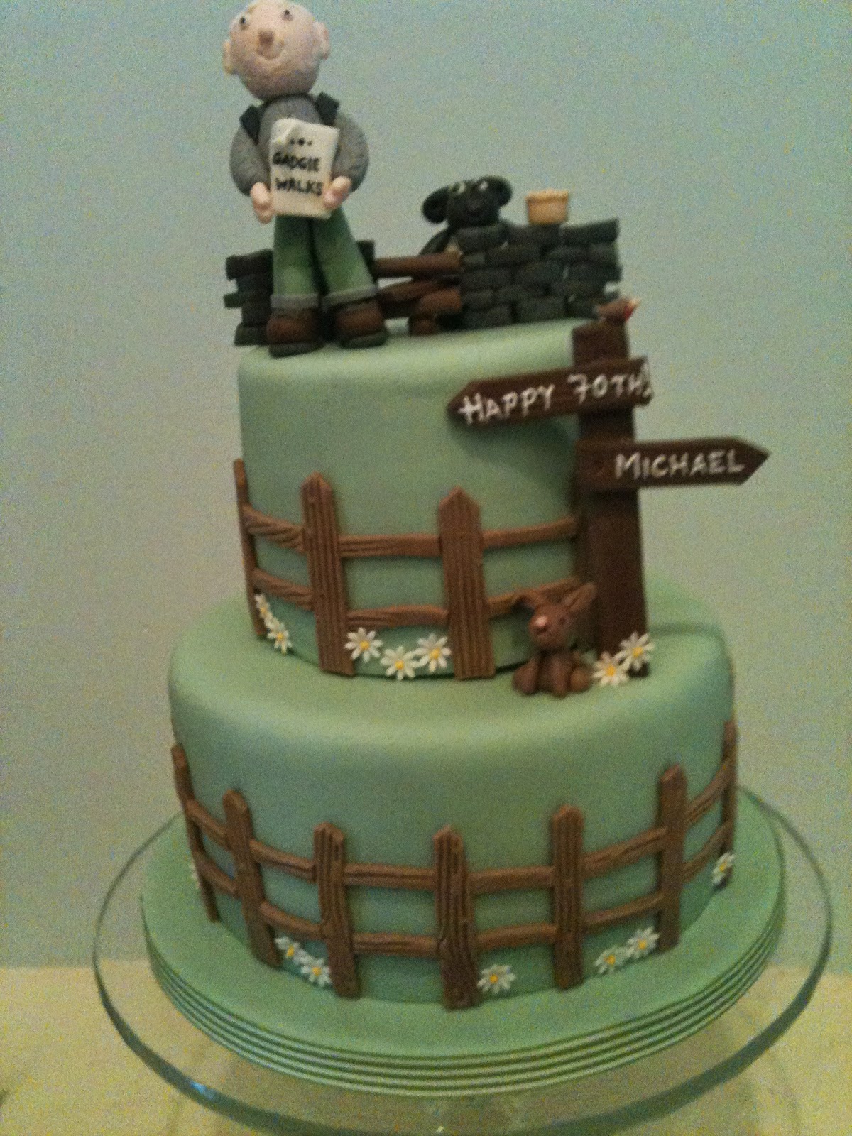
There are some jokes in it. For the full story go to:
http:cakepoppins.blogspot.co.uk/2014/04/the-devil-is-in-the-detail
Anglers
One of the advantages of having a birthday is that you get to choose the walk. April 5th is Harry's 69th birthday and it is my 70th so we have chosen the relatively local and well known walk from Ingram Centre to Brough Law, Old Fawdon Hill, the Conservancy ponds at Branton and the Anglers Arms at Weldon Bridge.
The disadvantage is that in a tradition stretching back over a year the birthday boys buy the beer. But as there are two of us, one with Yorkshire blood, we get to share a round or two.
The walk starts from the Muddy Boots cafe at the old Ingram Centre. To get there: A1 north, A697 at Morpeth and turn off left beyond Powburn on the road signed Ingram, turn left over the bridge go past the holiday cottages and the church. A map could well be useful, like all the best walks this one is covered by two maps: OL16 The Cheviot Hills and OS Explorer 332 Alnwick and Amble. The Cafe/centre is at GR NU020163.
Before we set out to walk we had breakfast at the Muddy Boots cafe, the place to eat in the Ingram Valley. A fine bacon sandwich in a bun, sauce and large tea pots, served by friendly ladies.
Because Mr. Gove the Minister of State for Education has decided to change the GCSE exam system (again) and have numbers instead of grades we thought we had better follow suit: on a scale of 1 to 9, 9 being the highest and only available to a few, we awarded an 8, slight problem with the quality of the bun!!
Leaving the car park we walked up the lane with the church and holiday cottages on the right. The church, St. Michael and all Angels, has origins going back to the 11th century but most of it is 19th century rebuilding. Today the village children were attending an Easter service, early but apparently school finishes today for the holiday.
St. Michael's and All Angels, Ingram.
At the village hall we turned right and continued walking west past Ingram Valley Farm, ignoring the first sign post we came to and following the metalled road for just over a mile before turning off on the left, walking a muddy path on the edge of a plantation before reaching the flattish top of Brough Law. Like many of the hilltops in this valley it has the remains of a fort, probably 4th C BC. A misty day not conducive to photography, but here is a picture of the remains of the rubble walls which once stood, possibly, 3 metres high.
Brough Law walls.
Having examined the fort (again!) but not the scenery as we couldn't see far, we headed south on a grassy path that meanders over the moors, with few markers to show the way. Avoiding the path that leads west to Chesters Burn we turned south east at the three mile marker (see map) before turning east and to the top of Cochrane Pike. Turning south east the walk descended to the Fawdon Burn and then we climbed up Old Fawdon Hill which has a trig point, an ancient settlement, (Given away on the map by Gothic Script) excellent views on clear days, unlike today, and, as it was quite warm and windy, was declared a Herbie Spot. Today's offerings included Mrs A's almond slices, ginger biscuits from Ben, Mr. Kipling's off cuts and ALDI chocolate.
Lunch on Old Fawdon Hill
Refreshed and rested after just over five miles the walk continued eastwards downhill. Normally we take the track heading north east to Fawdon Farm but today we walked on the north side of a plantation and round Gibb's Hill, which has a fort, then headed north to a farm called The Clinch which had a proper dog.
Patiently waiting for the shepherd, I sit and guard the quad bike from
old walkers.
From the Clinch there is a metalled road that took us to Fawdon Farm and following the signpost we walked north east across fields churned up by animals, eventually taking the marked path east and downhill to a road, turning left and entering the Branton Conservation Area. Here two old gravel pits have been flooded, landscaped and turned into wild life area. In theory there are otters (too many dog walkers about today), adders (too cold) and a variety of birds. We saw grey lags, Canada, Moorhens, coots, teal, widgeon and a yellowhammer, plus the usual collection of lbjs.
My new best friend.
After a while we left the bird hide and returned to the road, crossed the river Breamish River by the footbridge
The Breamish, some of the crew saw a heron.
Heddon Hill
Ridge and furrow too (at Fawdon)
At Reavelly a lady was feeding a fairly new lamb from a bottle of pop, I expect it was really milk.
From Reavelly we were soon back at the car park, changed and heading for the Anglers Arms at Wheldon Bridge where Harry and I, the birthday boys, generously treated the crew to Wild Goose or Bombardier.
The Anglers is a fine country pub which we frequently visit, so visit them at www.anglersarms.com.
The Matrix MMXIVL
steps miles
LIDL3D 28056 12.62
ASDAped 18078 8.49 ( A birthday gift, needs to be
properly hung, sort of)
DAV's 3D 26288 12
Dave's USB 25974 12.29
OUTDOOR GPS 12.1
Brian's GPS 12.1
Ben's bragometer not available
Gadgie distance 142 miles
A good 12 miler, enjoyable even in the mist which, incidentally, we had been informed by the weatherman would clear in the afternoon. He was wrong.
Ps
Last year a man asked if he could publish this blog in his new outdoor magazine. Thrilled I gave my permission, Sadly he could not get any advertising so the magazine only appeared on line.
Read the whole thing at: www. outdoorsne.co.uk
Pps
It was my birthday on Saturday.My daughter made me a brilliant, gadgie themed cake:
There are some jokes in it. For the full story go to:
http:cakepoppins.blogspot.co.uk/2014/04/the-devil-is-in-the-detail
Anglers
No comments:
Post a Comment