I'm just sitting here, reminiscing,
Thinking about the walks I'm missing.
Oh gadgies, whoa gadgies
Because of lockdown and the government's request that we only take walks from home gadgiedom is on hold until further notice. I have decided to revisit some favourite walks, a sort of virtual tour of past adventures.
The first one is a longish day out from the Harthope Valley over to the College Valley and then by way of the top of Cheviot back to the starting point.
The walk is covered by OS OL 16 The Cheviot Hills.
The start is as far down the Harthope Valley as visitors are allowed to drive. From Newcastle take the A1 north, the A 687 at Morpeth, turn into Wooler and turn left on the first street you come to, Cheviot Street. Follow this road, take the right fork and after a couple of miles turn right at the finger postb for Langleeford. Drive uphill, past Skirl Naked, over the Carey Bridge and on to the sign saying "No visitors beyond this point" There is a grassy area where you can park and yes, it's free.
We had breakfast at the Terrace café in Wooler first, friendly place on the high street. No need to ask the jock from BBC about the weather, it is perfect for walking, warm enough for shorts and a T shirt if you are that way inclined, blue skies and a very light breeze to cool the brow. Shorts are losing popularity as there is an increase in the number of lyme bearing tics in the area and it is a very unpleasant disease, as Harry will tell you.
A full team out today.
 Today's car park in Harthope Valley, grassy and by the stream. Good for washing muddy boots
Across the road from the grassy parking lot is a footpath that goes alongside Hawsen Burn. At this time of year we have seen ring ouzels in the burn area and, when it's sunny, like today, adders.
 An English adder, Britain's only poisonous snake. They scuttle off as you approach, usually
 Ring ouzel. Member of the thrush family and a summer visitor
The path joins a farm track which leads north west to Broadstruther, favourite gadgie Herbie Spot but on this walk take the footpath to the left which at times is a track then a path and finally reaches a stile in the fence line having climbed steadily but not too steeply. Crossing the heathery bits can be boggy too.
 Stile, with marker
Once over the stile the path goes downhill until it reaches a forest track. Turn right, through a gate and follow the track for a short distance before taking the footpath on the left. Initially through a wood but then across open fields until it reaches Goldscleugh.
 Looking down to the College Valley
This farm is possibly named after Golda, whoever he was, and is his ravine.
The old farm house is deserted, replaced by a more modern building.

 Weather station and house at Goldscleugh.
 View down the Lambden Burn.
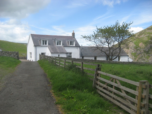
From Goldscleugh there is a metalled road alongside the Lambden Burn to the next farm at Dunsdale. This farm house appears to have been converted to holiday lets and what a peaceful place it must be.
At the back of the farm yard is an open barn which makes an ideal Herbie Spot. We shared flapjacks, biscuits, lemon slices, cheese scones from Mrs A and home made tablet from daughter Kate for my birthday. If you are not familiar with it Tablet is pure tooth rot, a form of fudge, from Scotland. Having said that my dentist advises me to eat fudge and not toffee as it is less likely to pull fillings out.
There is a footpath at the back of the farm which takes you across several fields, usually with several cows. There is a good view of Mounthooly, Youth Hostel and bunkhouse which is nearly at the top of the College Valley.
 Mounthooley YH and bunkhouse. Almost at the head of the College Valley which I think is the prettiest of the Cheviot Valleys. Privately owned it is open to only twelve cars a day and a permit is obtained from John Sale Estate Agents in Wooler for £10. The most famous resident of the valley was Cuthbert Collingwood, the victor of Trafalgar in 1805. He took over command when Nelson was killed. The Grey family of the tea, also owned the valley once.
 It's not very clear but look carefully and you can make out the outline of an ancient settlement by the trees and some ridge and furrows running across the picture.
The path goes down to the valley bottom and a track leads further up the valley until it fades away.
At this point you need to make a decision, Henhole or Mountain Refuge.
 The Hen Hole. It's a good scramble up the side of a stream with several attractive waterfalls to admire. At the top of the scramble is an open bowl and a path to Auchope Cairn
Being older but not necessarily wiser we have opted today to take the steady climb up to the Mountain Refuge Hut.
 The mountain refuge hut is on the Pennine Way. We have come to it today because Dave once left his pedometer inside and he wants to know if its still there. It isn't.
From the hut the path leads up to Auchope Cairn and beyond that the border fence which divides England from Scotland. Turning left, roughly west the flagged footpath follows a spur on the Pennine Way to the summit of Cheviot.
 Ray at Auchope Cairn
 Not for the purist but the top of Cheviot is very boggy m,ost of the year and it is a popular walk so the Yorks/Lancs flagstones serve well
 Cheviot Summit, 2674 feet or 815 metres if you must
Close to where the path from Auchope Cairn meets the path to the summit is the wreckage of a B19 US bomber which crashed during WW2. There are several such sites on the Cheviot range but this is one of the few where there is much left. Some of the crew were rescued.
From the Cheviot summit the path leads downhill, thankfully, in a north east direction, crosses Scald Hill and continues down alongside a fence. At a bend in the fence a footpath leads down to the south side of New Burn and joins the valley road close to Langleeford. From there a short stint on the road and back at the car park.
The walk is about 12 miles, some climbing, some great views.

Contains OS data. Copyright. Crown copyright and database right 2020
Thinking about the walks I'm missing.
Oh gadgies, whoa gadgies
Because of lockdown and the government's request that we only take walks from home gadgiedom is on hold until further notice. I have decided to revisit some favourite walks, a sort of virtual tour of past adventures.
The first one is a longish day out from the Harthope Valley over to the College Valley and then by way of the top of Cheviot back to the starting point.
The walk is covered by OS OL 16 The Cheviot Hills.
The start is as far down the Harthope Valley as visitors are allowed to drive. From Newcastle take the A1 north, the A 687 at Morpeth, turn into Wooler and turn left on the first street you come to, Cheviot Street. Follow this road, take the right fork and after a couple of miles turn right at the finger postb for Langleeford. Drive uphill, past Skirl Naked, over the Carey Bridge and on to the sign saying "No visitors beyond this point" There is a grassy area where you can park and yes, it's free.
We had breakfast at the Terrace café in Wooler first, friendly place on the high street. No need to ask the jock from BBC about the weather, it is perfect for walking, warm enough for shorts and a T shirt if you are that way inclined, blue skies and a very light breeze to cool the brow. Shorts are losing popularity as there is an increase in the number of lyme bearing tics in the area and it is a very unpleasant disease, as Harry will tell you.
A full team out today.

Across the road from the grassy parking lot is a footpath that goes alongside Hawsen Burn. At this time of year we have seen ring ouzels in the burn area and, when it's sunny, like today, adders.


The path joins a farm track which leads north west to Broadstruther, favourite gadgie Herbie Spot but on this walk take the footpath to the left which at times is a track then a path and finally reaches a stile in the fence line having climbed steadily but not too steeply. Crossing the heathery bits can be boggy too.

Once over the stile the path goes downhill until it reaches a forest track. Turn right, through a gate and follow the track for a short distance before taking the footpath on the left. Initially through a wood but then across open fields until it reaches Goldscleugh.

The old farm house is deserted, replaced by a more modern building.


From Goldscleugh there is a metalled road alongside the Lambden Burn to the next farm at Dunsdale. This farm house appears to have been converted to holiday lets and what a peaceful place it must be.
At the back of the farm yard is an open barn which makes an ideal Herbie Spot. We shared flapjacks, biscuits, lemon slices, cheese scones from Mrs A and home made tablet from daughter Kate for my birthday. If you are not familiar with it Tablet is pure tooth rot, a form of fudge, from Scotland. Having said that my dentist advises me to eat fudge and not toffee as it is less likely to pull fillings out.
There is a footpath at the back of the farm which takes you across several fields, usually with several cows. There is a good view of Mounthooly, Youth Hostel and bunkhouse which is nearly at the top of the College Valley.


The path goes down to the valley bottom and a track leads further up the valley until it fades away.
At this point you need to make a decision, Henhole or Mountain Refuge.

Being older but not necessarily wiser we have opted today to take the steady climb up to the Mountain Refuge Hut.

From the hut the path leads up to Auchope Cairn and beyond that the border fence which divides England from Scotland. Turning left, roughly west the flagged footpath follows a spur on the Pennine Way to the summit of Cheviot.


Close to where the path from Auchope Cairn meets the path to the summit is the wreckage of a B19 US bomber which crashed during WW2. There are several such sites on the Cheviot range but this is one of the few where there is much left. Some of the crew were rescued.
From the Cheviot summit the path leads downhill, thankfully, in a north east direction, crosses Scald Hill and continues down alongside a fence. At a bend in the fence a footpath leads down to the south side of New Burn and joins the valley road close to Langleeford. From there a short stint on the road and back at the car park.
The walk is about 12 miles, some climbing, some great views.

Contains OS data. Copyright. Crown copyright and database right 2020
No comments:
Post a Comment