Get thee to a nunnery lads...................April 22nd (Northumberland)
An appropriate quote for today's walk as it is nearly April 23rd, the 400th anniversary of the death of the bard. We are off to start a walk from Holystone in Northumberland. In 1124 the Benedictines founded the nunnery here. It was taken over by the Augustinians in the 13th century and presumably went out of business under Henry. Little survives in the nave of the church and the churchyard wall. The church (St.Mary's) was the nunnery chancel bits are medieval but most is 19th century reconstruction.
 St Mary the virgin, Holystone.
To get to Holystone take the A1 north, A697 at Morpeth go through Rothbury, the road has been repaired at last, on the B6341 and turn right on the narrow number free road to Holystone. There is parking by the information centre.
A grand turn out today; Brian, Ben, Harry, three Johns, Dave, Norman and me. We stopped for breakfast at Tomlinsons bunkhouse and cafe for breakfast, always worth a call, friendly service, good tea and bacon sandwiches for those who indulge.
The walk; Through the village and up a track there is a parking area by kind permission of the Forestry Commission. On OS OL 16 The Cheviot Hills the park is at NT949025. And the map is highly recommended for this walk as are gaiters as parts of it are very muddy.

Picnic table and free car park,
We left the car park and turned right up a forestry track that at some point follows the line of a Roman Road. After about a mile we turned right into the wood at a sign post pointing towards Rockey's Hall.
 Enter the wood at this point.
The track goes through the plantation to Rockey's Hall but we took a diversion along narrow winding and muddy paths to look at Dove Crag, an interesting rocky cliff and almost a cave.

 Giant stalagmite at Dove Crag, and Norman, leader for the day.
Having admired Dove Crag we headed along narrow paths to rejoin the trak to Rockey's Hall where we turned left on the road to Harbottle, pretty Northumbrian village we usually drive through on the way to Alwinton. Harbottle has a ruined castle and a very useful car park which was designated a Herbie Spot, it had good views and a low wall to sit on.
 Mrs Clennel's memorial in Harbottle.
 Ruined Harbottle Castle

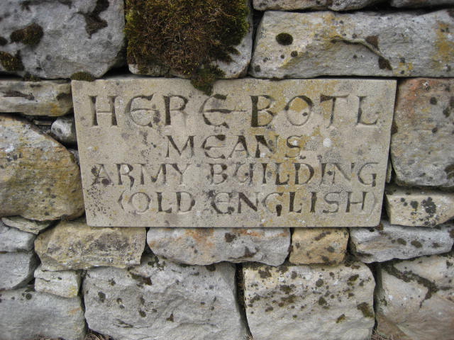 Old English hyra-botl meaning "hirelings' building" OR here-botl, an "army building"
 Harking back to the days of the border wars
 Today's feast included, mini quiche from Mrs A. Birthday cake from Mrs Ha. ginger biscuits from Ben, Czech chocolate, caramel shortcake and caramel with chocolate. We walk it off.
 Large stone in the car park. The footpath to the castle was closed in April for lambing.
Lunch over we walked a short distance up the road before following the sign post that took us on a footpath which climbed steadily to the Drake Stone, a large chunk of rock that we would all have climbed in younger days.
 Looking down on Harbottle

 The Drake stone
From the stone we headed for Harbottle Lake and then turned north along a fence line. We were in Ministry of Defence land but there were no red flags and we didn't pick anything up.
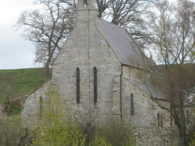
 We turned east at the Swire , walked down a track and turned left on the road to Alwinton. At Low Alwinton we turned back on ourselves along a familiar track past St Michael's church, a Lime Kiln and a house that never seems to be occupied.
 St Michael's, Low Alwinton
 Lime Kiln at Low Alwinton.
We crossed a footbridge and were back in Harbottle, from where we followed the road to Rockey's Hall.
 Rockey's Hall
We took the track at the hall and headed south east along the edge of the wood to North Wood. The path here was closed, a diversion was well marked with yellow ribbons tied to the old trees, some of which were indeed oaks. At he end of the wood we took a path across the field to Lady's Well.


 A watering hole next to the Roman road and possibly the place where St Paulinus converted 3000 wild Northumbrians to the Christian faith. The cross is 19th century and the statue 18th century. The place is a National Trust property.
 And from the well we walked up the track to the car park.
Surprisingly we stopped at the Anglers Arms in Weldon Bridge on the way home which had the usual three real ales on tap, Taylor's Golden Bitter, Youngs and another. The coffee was excellent too.
The Matrix MMXVI M
steps miles
NAK 30861 11.68
LIDL3D 25642 11.5
Dave's 3D 24594 11.56
" LIDL3D 23270 11.01
" NAK 23096 10.93
etrex 10.7

Contains OS data copyright. Crown copyright and database right 2016


 Or you could live in London
An appropriate quote for today's walk as it is nearly April 23rd, the 400th anniversary of the death of the bard. We are off to start a walk from Holystone in Northumberland. In 1124 the Benedictines founded the nunnery here. It was taken over by the Augustinians in the 13th century and presumably went out of business under Henry. Little survives in the nave of the church and the churchyard wall. The church (St.Mary's) was the nunnery chancel bits are medieval but most is 19th century reconstruction.

To get to Holystone take the A1 north, A697 at Morpeth go through Rothbury, the road has been repaired at last, on the B6341 and turn right on the narrow number free road to Holystone. There is parking by the information centre.
A grand turn out today; Brian, Ben, Harry, three Johns, Dave, Norman and me. We stopped for breakfast at Tomlinsons bunkhouse and cafe for breakfast, always worth a call, friendly service, good tea and bacon sandwiches for those who indulge.
The walk; Through the village and up a track there is a parking area by kind permission of the Forestry Commission. On OS OL 16 The Cheviot Hills the park is at NT949025. And the map is highly recommended for this walk as are gaiters as parts of it are very muddy.

Picnic table and free car park,
We left the car park and turned right up a forestry track that at some point follows the line of a Roman Road. After about a mile we turned right into the wood at a sign post pointing towards Rockey's Hall.

The track goes through the plantation to Rockey's Hall but we took a diversion along narrow winding and muddy paths to look at Dove Crag, an interesting rocky cliff and almost a cave.


Having admired Dove Crag we headed along narrow paths to rejoin the trak to Rockey's Hall where we turned left on the road to Harbottle, pretty Northumbrian village we usually drive through on the way to Alwinton. Harbottle has a ruined castle and a very useful car park which was designated a Herbie Spot, it had good views and a low wall to sit on.


Lunch over we walked a short distance up the road before following the sign post that took us on a footpath which climbed steadily to the Drake Stone, a large chunk of rock that we would all have climbed in younger days.


From the stone we headed for Harbottle Lake and then turned north along a fence line. We were in Ministry of Defence land but there were no red flags and we didn't pick anything up.


We crossed a footbridge and were back in Harbottle, from where we followed the road to Rockey's Hall.

We took the track at the hall and headed south east along the edge of the wood to North Wood. The path here was closed, a diversion was well marked with yellow ribbons tied to the old trees, some of which were indeed oaks. At he end of the wood we took a path across the field to Lady's Well.


Surprisingly we stopped at the Anglers Arms in Weldon Bridge on the way home which had the usual three real ales on tap, Taylor's Golden Bitter, Youngs and another. The coffee was excellent too.
The Matrix MMXVI M
steps miles
NAK 30861 11.68
LIDL3D 25642 11.5
Dave's 3D 24594 11.56
" LIDL3D 23270 11.01
" NAK 23096 10.93
etrex 10.7

Contains OS data copyright. Crown copyright and database right 2016


No comments:
Post a Comment