Six go to Split the Deil (Northumberland) August 31st
Holidays are over! Almost back to full strength. Six of us are out in the Cheviots again, walking to Windy Gyle on the border with Scotland. (John H., John C., Brian, Harry, Ben and me.) For foreign readers it's an open border, both countries still in the UK (at the moment), and the EU too.
To get to the start take A1 north, A697 at Morpeth ,turn left at Weldon Bridge for Rothbury, drive through the town and turn right when you spot the signpost for Alwinton. Keep going beyond Alwinton and park int he small car park on the left at Barrowburn just before the old valley hall
The map to use is OS OL 16 Cheviot Hills and it is useful to have it with you although the tracks are mostly visible. The car park at Barrowburn is at GR NU 023024
Of course we stopped in Rothbury at Tomlinsons Café and bunkhouse for breakfast. Highly recommended, you can have coffee without going through a list of choices and they do a good bacon sandwich.
 This week's country car park should get approval from one reader. With the hatches open it looks like a car show room. Why do they do it?
August 31st is, according to meteorologists, the last day of summer, autumn kicks off tomorrow. The same profession promised us a bright, warm, sunny morning with cloud approaching in the afternoon. They were right. Beautiful morning, sun blazing down from an azure sky, the team wearing T shirts, except at Herbie time when we all remembered mother's advice and put tops on so as to "get the benefit."
Leaving the car park we walked left up the road towards the farm at Barrowburn, taking the track in front of the building and turning left immediately after the buildings to follow the grassy track over Barrow Law.
 Barrowburn farm. Turn left after the buildings. A few years ago the farm had a tea room but no longer.
The track goes quite gently over the Law and down to the corner of Trows Plantation at Murder Cleugh.
 The track over Barrow Law, grassy going, easy on the feet.


 The grassy track from Windy Gyle
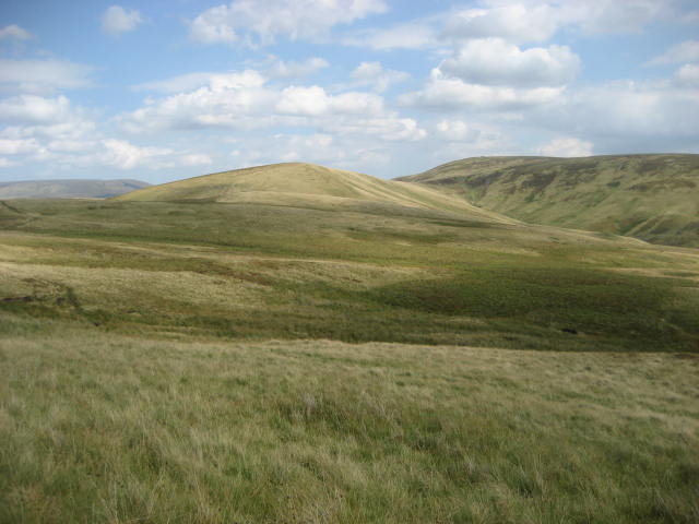
 Rolling hills of Northumberland

 The locals
 Information board at Rowhope Burn, in poor condition but it does explain that The Slime was once a pub. Bearing in mind this is on one of the old drove roads between England and Scotland a pub is not surprising.


Holidays are over! Almost back to full strength. Six of us are out in the Cheviots again, walking to Windy Gyle on the border with Scotland. (John H., John C., Brian, Harry, Ben and me.) For foreign readers it's an open border, both countries still in the UK (at the moment), and the EU too.
To get to the start take A1 north, A697 at Morpeth ,turn left at Weldon Bridge for Rothbury, drive through the town and turn right when you spot the signpost for Alwinton. Keep going beyond Alwinton and park int he small car park on the left at Barrowburn just before the old valley hall
The map to use is OS OL 16 Cheviot Hills and it is useful to have it with you although the tracks are mostly visible. The car park at Barrowburn is at GR NU 023024
Of course we stopped in Rothbury at Tomlinsons Café and bunkhouse for breakfast. Highly recommended, you can have coffee without going through a list of choices and they do a good bacon sandwich.

August 31st is, according to meteorologists, the last day of summer, autumn kicks off tomorrow. The same profession promised us a bright, warm, sunny morning with cloud approaching in the afternoon. They were right. Beautiful morning, sun blazing down from an azure sky, the team wearing T shirts, except at Herbie time when we all remembered mother's advice and put tops on so as to "get the benefit."
Leaving the car park we walked left up the road towards the farm at Barrowburn, taking the track in front of the building and turning left immediately after the buildings to follow the grassy track over Barrow Law.

The track goes quite gently over the Law and down to the corner of Trows Plantation at Murder Cleugh.


Murder Cleugh (Cleugh = clough, a ravine) I suppose it was quick.
Just beyond the memorial is a gate, we turned right and then almost immediately left on a barely visible footpath that led to a wobbly stile. Once over the wobble we walked across the field, contouring Ward Law and found the track that goes to Scotchman's Ford and then on to Russell's Cairn at Windy Gyle where we called a Herbie. Windy Gyle is on the border fence and has superb panoramic views. The Cheviot to the east, Scotland to the north and England to the south.

Wobbly stile
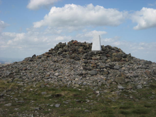
Russell's Cairn. So named for Lord Russell who was murdered here at a meeting of the wardens of the marches in 1588. The wardens tried to keep the peace between the Scots and English.
I don't suppose the trig point was there then.

Herbie time in the small cairn and shelter next to Russells. (Nutty bars, cookies, ginger biscuits and some fine cheese cake from Mrs A). Sunny but windy, appropriate for a place called Windy Gyle. Close to the cairns, on the map, is something called Split the Deil. I can't find any reference to it, it's not printed in Gothic script so can't be ancient. I have decided it should really be Split the Devil, perhaps Beelzebub called in here. Anybody who can explain, please let me know.
Herbie time over we followed the track west to Plea Knowe where it turned south over the Black Braes Brian, John H., and Ben were ahead of we other three at this point and spotted a red squirrel on the Scottish side of the border. Very strange, the nearest trees are several miles away. My personal opinion is that, Hamlet like, he was heading for England as he had heard it was a country full of nuts.
On previous walks in this area we have seen the feral Cheviot goats but not today.


Heading back, the promised clouds gathering.
Beyond Black Braes the path crosses Swineside Law, Bought Law and a patch called the Slime before heading down hill to a small car park where the road crosses Rowhope Burn. The track is called the Street, it's an old drove road.


Close up of the board. Near the top, on the left a Whisky Still, one of several in the area, is marked. Great places to brew up, miles from civilisation, easy to spot the excise men on their way, and drovers calling in regularly.
From the Rowhope Burn we walked back to the car park, changed and drove back to Alwinton to rehydrate at the Rose and Thistle. Nice friendly pub, and they had Timothy Taylor's Landlord on draught! A good Yorkshire pint after a good Northumberland walk. At about ten miles I would recommend this walk any time of year, the scenery is magnificent, the climbs are fairly gentle and the paths are easy to find and follow.

Contains OS data copyright. Crown copyright and data base right 2018
Matrix MMVIII 8(2)
steps miles
NAK 27568 10.44
iPhone 23672 9.7
etrex 9.95
Brian View Ranger 9.5
Brian other 9.6
3 hours 48 minute walking 50 minutes talking 1900 feet of ascent.


No comments:
Post a Comment