Who ate all the pies? * Or ring a ring a Roseberry (North Yorks) Sept 14th.
It's a while since we have been to the North Yorks Moors, today we are heading initially to Great Ayton to buy pies from Petch's Famous pie shop and then to have a walk based on the lump of rock called Roseberry Topping. A good turn out, a septet of gadgies: Dave, Harry, Brian, Ben, John H., John C. and me.
The walk starts at Pinchingthorpe, nature reserve and café, but we went to Great Ayton first to have breakfast at Stamps Café and to buy pies from Petch's Prize Winning Pie shop.
To get to the start from base, take the A19 south through the Tyne Tunnel and just beyond Middlesborough join the A174 and then the A171 and finally turn off on the right for Pinchingthorpe. The map for the walk is OS OL26 North York Moors,Western area and the car park at the start is at GR NZ 571138.
Although in Yorkshire this car park at Pinchinthorpe, Guisborough Nature, charges £3 a day which, compared to the Lake District is very cheap.
We headed east from the car park, passing the café, railway carriage and several large carvings of animals
Shooting box
It's a while since we have been to the North Yorks Moors, today we are heading initially to Great Ayton to buy pies from Petch's Famous pie shop and then to have a walk based on the lump of rock called Roseberry Topping. A good turn out, a septet of gadgies: Dave, Harry, Brian, Ben, John H., John C. and me.
The walk starts at Pinchingthorpe, nature reserve and café, but we went to Great Ayton first to have breakfast at Stamps Café and to buy pies from Petch's Prize Winning Pie shop.
To get to the start from base, take the A19 south through the Tyne Tunnel and just beyond Middlesborough join the A174 and then the A171 and finally turn off on the right for Pinchingthorpe. The map for the walk is OS OL26 North York Moors,Western area and the car park at the start is at GR NZ 571138.
Although in Yorkshire this car park at Pinchinthorpe, Guisborough Nature, charges £3 a day which, compared to the Lake District is very cheap.
We headed east from the car park, passing the café, railway carriage and several large carvings of animals
There are climbing activities for children close to the carvings.
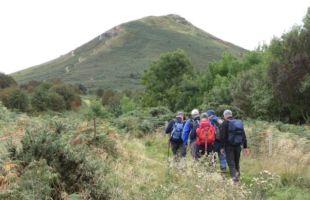
There are also a number of signed walks in the area, we continued east through woodland before turning south east and passing Home Farm until, after a couple of fields we were in Hutton Lowcross Woods. And as we left the woods we had good view of Roseberry Topping.
Roseberry Topping, a local landmark. The area has been inhabited since the bronze age. In 1910 part of the mountain collapsed leaving it with its distinctive shape. Not really a mountain at 1050 feet but it's a steep climb and a popular one too.
There are several paths to the top of the hill, one clearly visible in the picture. On the top there is a trig point and views of the surrounding country, and Middlesborough.
Roseberry Trig point, well done Jan and co.
Somebody thinks it's Herbie Time, wrong. (Photo by DK associates)
WE took a very steep and stony path down, heading west of south on a track that had small stones that can act as ball bearings. Once on the more level ground we crossed fields parallel to Newton Woods, passing this fine shooting box on the way.

As we entered Cliff Ridge Wood we called a Herbie Stop, treating each other to Ben's biscuits, Titans, two varieties of flapjack, Titan bars from ALDI and ginger with lemon and poppy seed iced cake from Mrs A.
This frame is placed to give you a view of old Roseberry. It says on the top bar "Some look but do not see".
Gadgies in the frame, all looking and probably seeing too. (DK picture)
Herbie time over we walked through the wood in the only shower of the day, and a light one at that. We turned north at the road before Quarry House then left along a track to Langbaurgh quarry. At the quarry the footpath turned north and took us through an unusual area. Much of the land was growing willows, there were several fishing ponds, reserved for residents only, but few houses, apart from Eastfield Farm.
Willows and teazels
One of several fish ponds.
From Eastfield farm the footpath, which is quite well signed with large black arrows on yellow background, heads north then west for a short distance then north again then east.
Close to Morton Grange we crossed the single track railway and several fields before joining the disused railway line for the short walk back to the car park.
John Deere at work, ploughing the field before the scattering of seed upon the land.
Once there was a railroad
Changed we drove a few miles down the road to the Kings Arms Hotel and pub. On offer was a beer called Thirst Aid and an orange stout. The beer was fine.
The King's Head
And another view of Roseberry Topping
Contains OS data, copyright. Crown copyright and database right 2018
* And here is the answer
And a super matrix MMXVIII 9b
steps miles
NAK 28231 10.69
Dave's NAK 2 20930 9.57
"" USB 21295 9.73
"" NAK1 20935 9.85
Sylvia's mother 21564 9,26
Brian's VR 9.54
JC 10.02
Etrex 10.0
More pictures from DK Associates


No comments:
Post a Comment