Castles in the air (The Hill Forts Trail) Cheviots....... October 2nd.
An extra walk for Dave and I, repeating the Hill Forts Trail we did in June last year (Fort Votadini, The Cheviots)
The walk starts from the car park at Hethpool at the entrance to the College Valley. (Directions; A1 North, A697 at Morpeth, turn left beyond Wooler on the road for Yetholm, turn left at the sign post for Hethpool and follow the narrow road, there is a car park just beyond the row of cottages. If you wish to drive down the College Valley you need a permit from John Sales estate agents in Wooler, cost £10, twelve cars allowed a day)
The map is OS OL 16, The Cheviot Hills and the car park is at GR NT893280
Note. To enjoy this walk it helps if you like piles of stones and enjoy several steep climbs.

 Car Park at Hethpool and a useful information board.
We walked back past the rows of cottages and along the road to the junction that takes you back to the Yetholm road or left to Eldonburn. We turned left but almost immediately left the road and followed the Hill Fort Trail up a grassy track in the direction of White Hill.
The trail is fairly well posted but some of the markers have been pushed over by sheep using them as scratching posts.
 Some say Hill fort, some say Hillfort.
The trail wanders over moorland which has Cultivation Terraces, homesteads and cairns before going through a plantation. Emerging there is a climb to Ring Chesters, first Hill Fort of the day, and a fine example it is too. Iron Age (from 800BC to 43AD, how precise). The enclosure contains circular stone foundations and at least eight hut circles.
 It could have been a hearth inside a hut
 The banks at Ring Chesters are plain to see but difficult to photograph.
Moving on South West we visited the Homestead and field systems still visible near a relatively modern sheep pen and dipping area. We retraced our steps for a short distance before following the trail down to the farm at Elsdonburn, walked along the road until we spotted the next marker and headed south east and uphill to the next fort, Little Hetha. This fort has Iron Age origins but also evidence of Medieval Occupation(Medieval is from 1066 to 1540)
Returning from the fort we began the steep climb to Great Hetha, another Iron Age fort with ramparts of earth and stone. Sitting on the east side, downhill slightly to be out of the breeze, we called a Herbie Spot. Short rations as there were only the two of us, we exchanged pork pies for Club chocolate covered biscuits.
The views from Great Hetha are worth the effort;
 Remains of the ramparts on Great Hetha
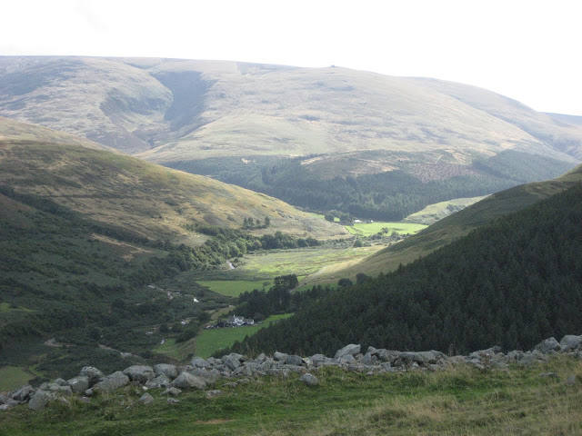
 Looking down on Hethpool House, once the home of Admiral Lord Collingwood, Nelson's number two at Trafalgar.
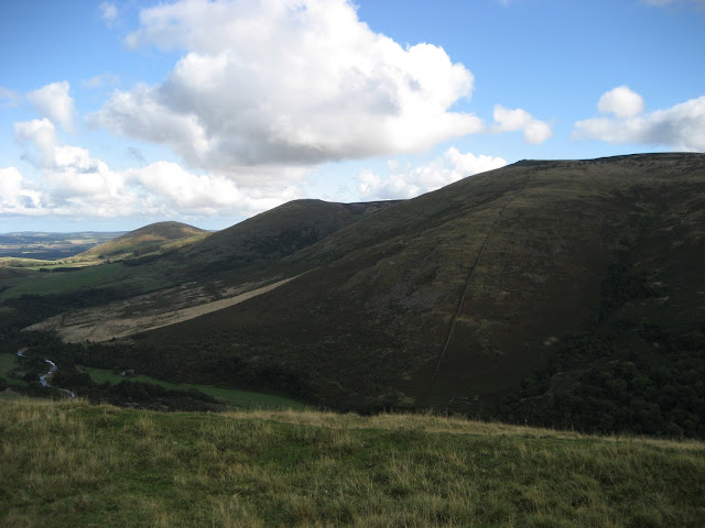
 The Cheviot fro Great Hetha, College Valley below
Lunch and exploration over we headed south east down to Trowupburn, passing on the way the small stand of trees where we had turned down parts in Beowulf last year. It might have been more successful had we been in it.
 Trowupburn casting couch
The trail goes round the tiny farm at Trowupburn and goes up a steep hill covered with bracken, difficult to walk through as it tries to trip you up, although many a young maiden has been tumbled in the bracken I am told.
 Trowupburn Farm, didn't look like a working farm. (And bracken)
At the top of the field we entered a plantation, much of which has been recently felled. This allowed us to visit the next fort, Sinkside, which has been inaccessible in recent years. Not having four legged lawn mowers near it the fort interior is covered with long grass. Another Iron Age fort with some evidence of post medieval use (1540 to 1901.) in the shape of sheepfolds, bring the little grass hungry beggars back.
Retracing steps to the forest trail we headed carefully downhill. Carefully as the track has small stones that act like marbles and cause unwary walkers to fall. Shortly after passing a sort of timber yard we spotted, almost hidden by the bracken, a marker which took us through the wood, (This path is hard to follow it is so rarely used, basically head south east till you come to a point where you can cross the stream) across a stream and to the footpath to the top of North Black Hagg, the final fort of the day. This was another steep climb, but again the views from the Iron Age fort made the effort worth while, and I must admit to getting tired as we finished the climb.
 The remains of the ramparts on North Black Hagg, and a modern cairn
 The Cheviot, the centre giant gully is The Bizzle, a good walk/scramble.
After battling more bracken as we walked south and downhill, we hit the valley road, turned north and walked back to the car park, passing Cuddystone Hall and the RAF memorial on the way.
 Cuddystone, the Valley Hall

 The memorial to the men and machines which crashed in the Cheviots in WW2
The Matrix MMXVI ZZZZZZ
steps miles
NAK 40354 15.28
Dave's 3D 33290 14.65
" USB 31198 14.27
" NAK 30669 14.03
Etrex 13.16 5 hr 42 min walk 2hr 7min talk
OUTDOOR GPS 13.7
Step counter on iPhone 33337 14.41

Contain OS data copyright. Crown copyright and database righ t2016


An extra walk for Dave and I, repeating the Hill Forts Trail we did in June last year (Fort Votadini, The Cheviots)
The walk starts from the car park at Hethpool at the entrance to the College Valley. (Directions; A1 North, A697 at Morpeth, turn left beyond Wooler on the road for Yetholm, turn left at the sign post for Hethpool and follow the narrow road, there is a car park just beyond the row of cottages. If you wish to drive down the College Valley you need a permit from John Sales estate agents in Wooler, cost £10, twelve cars allowed a day)
The map is OS OL 16, The Cheviot Hills and the car park is at GR NT893280
Note. To enjoy this walk it helps if you like piles of stones and enjoy several steep climbs.


We walked back past the rows of cottages and along the road to the junction that takes you back to the Yetholm road or left to Eldonburn. We turned left but almost immediately left the road and followed the Hill Fort Trail up a grassy track in the direction of White Hill.
The trail is fairly well posted but some of the markers have been pushed over by sheep using them as scratching posts.

The trail wanders over moorland which has Cultivation Terraces, homesteads and cairns before going through a plantation. Emerging there is a climb to Ring Chesters, first Hill Fort of the day, and a fine example it is too. Iron Age (from 800BC to 43AD, how precise). The enclosure contains circular stone foundations and at least eight hut circles.


Moving on South West we visited the Homestead and field systems still visible near a relatively modern sheep pen and dipping area. We retraced our steps for a short distance before following the trail down to the farm at Elsdonburn, walked along the road until we spotted the next marker and headed south east and uphill to the next fort, Little Hetha. This fort has Iron Age origins but also evidence of Medieval Occupation(Medieval is from 1066 to 1540)
Returning from the fort we began the steep climb to Great Hetha, another Iron Age fort with ramparts of earth and stone. Sitting on the east side, downhill slightly to be out of the breeze, we called a Herbie Spot. Short rations as there were only the two of us, we exchanged pork pies for Club chocolate covered biscuits.
The views from Great Hetha are worth the effort;


Lunch and exploration over we headed south east down to Trowupburn, passing on the way the small stand of trees where we had turned down parts in Beowulf last year. It might have been more successful had we been in it.

The trail goes round the tiny farm at Trowupburn and goes up a steep hill covered with bracken, difficult to walk through as it tries to trip you up, although many a young maiden has been tumbled in the bracken I am told.

At the top of the field we entered a plantation, much of which has been recently felled. This allowed us to visit the next fort, Sinkside, which has been inaccessible in recent years. Not having four legged lawn mowers near it the fort interior is covered with long grass. Another Iron Age fort with some evidence of post medieval use (1540 to 1901.) in the shape of sheepfolds, bring the little grass hungry beggars back.
Retracing steps to the forest trail we headed carefully downhill. Carefully as the track has small stones that act like marbles and cause unwary walkers to fall. Shortly after passing a sort of timber yard we spotted, almost hidden by the bracken, a marker which took us through the wood, (This path is hard to follow it is so rarely used, basically head south east till you come to a point where you can cross the stream) across a stream and to the footpath to the top of North Black Hagg, the final fort of the day. This was another steep climb, but again the views from the Iron Age fort made the effort worth while, and I must admit to getting tired as we finished the climb.


After battling more bracken as we walked south and downhill, we hit the valley road, turned north and walked back to the car park, passing Cuddystone Hall and the RAF memorial on the way.


The Matrix MMXVI ZZZZZZ
steps miles
NAK 40354 15.28
Dave's 3D 33290 14.65
" USB 31198 14.27
" NAK 30669 14.03
Etrex 13.16 5 hr 42 min walk 2hr 7min talk
OUTDOOR GPS 13.7
Step counter on iPhone 33337 14.41


No comments:
Post a Comment