Translate

Friday, 22 May 2015

Beside the seaside again................May22nd
Foiled again by the weather we have decided not to cross to the west side of the country for a walk in the Lake District but to stay nearer home where we are promised a dry day. Furthermore as some of us are suffering from slightly damaged leg muscles we are having a relatively flat walk along the coast. One that has been done several times before, one that requires at least two cars or a bus.
The walk starts from Craster (Camp where the crows live). To get there take the A1 north. Just beyond Alnwick (pronounced Annick) turn off the A1 and head east, following sign posts for Seahouses before following signs for Craster. There is a car park just as you enter the village, complete with an information centre and toilets .A charge of £2 for the day is very reasonable.
                                                         This week's car park
There are six of us today, John C, Brian, Ben, Dave, Harry and me
The walk is covered on two maps OS Explorer 332 Alnwick and Amble and OS 340 Holy Island and Bamburgh, but as the walk follows the coast you could go without.
We started with breakfast (for some ) in the Shoreline Cafe, it was quite busy, not surprising as it has good bacon sandwiches I am told and proper tea, plus friendly staff.
             And this week's cafe.
Once out of the cafe we headed north past the Jolly Fisherman pub, famous for its crab sandwiches, 
past the harbour  and on towards Dunstanburgh Castle.
                                                            It's a good pub, but we are heading north
                                                                    Craster Harbour
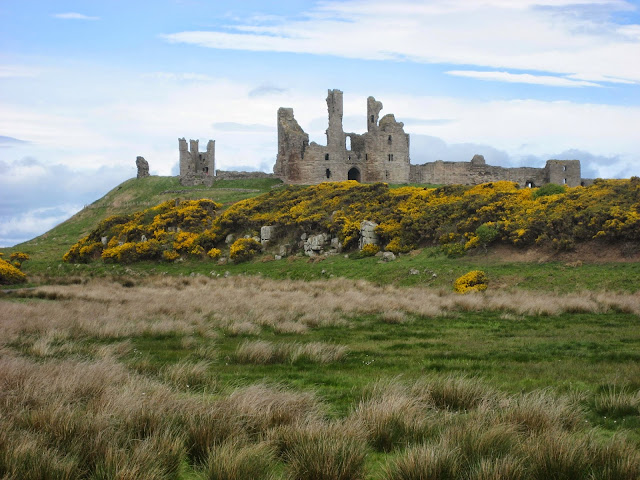
                                                                The ruined but still impressive Dunstanburgh castle.
                                               Those Lancastrians certainly knew how to build
                                                          The Lilburn Tower
      A text book example of an anticline, just north of Dunstanburgh Castle, Newton in the background.
The footpath, which at this point is the Northumberland Coastal Path and St. Oswald's Way crosses the Dunstanburgh golf course, watch out for flying golf balls. But after a while it is possible to walk down to the beach, cross a few yards of large, well rounded boulders and walk along the sandy beach of Embleton Bay. A large curve of sand, very few visitors today, a shame as  the weather was warm with a slight breeze. Next Monday, being  a public holiday, it will be heaving with families. At the north end of the bay is the small square of cottages and a pub that comprise the hamlet of Low Newton by the Sea. The pub, The Ship, frequently appears in articles in the quality  newspaper articles on where to eat out. One of the few pubs north of Watford to be so honoured. It also has a micro brewery. However we called a Herbie Spot and sat on benches in the square.
Lunch today, apart from the healthy sandwiches we carry, was enhanced by Mrs A's home made chocolate chip cookies, superb, Ben's ginger biscuits, up to their usual high standard, fruit flapjack, milky way and chocolate.  (Only 179 lbs this morning, the diet is working, slowly).
                                    A patch of cowslips. There are plenty of flowers out at the moment
                                            The Ship, Low Newton by the Sea
                                                            Embleton Bay, almost empty
                                                There's a plaice for us
Lunch over we continued for a short way up the road before going through the gate on the right that crosses fields,still on the coastal path and St. Oswald's way until it was possible to walk down onto the beach of Beadnell Bay. Just before the Brunton Burn enters the sea there is, in summer, an area of beach roped off. It is the home to a large colony of terns, mostly of the Sandwich variety. RSPB members try to keep the foxes away from the vulnerable nests. We were told there were about 500 birds there, they made enough noise. If the tide is in it is necessary to go inland and cross the burn by the footbridge but the water was well out today, we walked across the low stream and continued to Beadnell, another Northumberland fishing village.
                  The lime kilns at Beadnell, now used as storage by fishermen
                                           Lobster pots and a distant Dunstanburgh Castle
                                                    Beadnell Harbour
                                                   A safe place to nest inside the kilns
We walked through the village and near the campsite again descended to the beach. We continued on the beach  to the Snook, climbed up to the golf course, which we crossed with care, flying balls again, and followed the footpath into Seahouses and to the Olde Ship hotel. This pub has a good range of beers from local breweries, some fun names like Shuggyboat, and it also had Black sheep from Theakstons and Old Speckled Hen.
                                           Seahouses Harbour, take a trip to the Farne Islands from here. 
                                         Bamburgh Castle in the background.

                                               Kittiwakes nesting on the cliffs at Seahouses

THE MATRIX MMXV  K
                                                                              steps                            miles
LIDL 3D                                                                23761                        9.9
Hi Gear                                                                  22514                       10.2
Dave's LIDL 3D                                                    22235                       10.2
Dave's USB                                                            22460                       10.36
OUTDOOR GPS                                                                                     10.2
Brian's GPS                                                                                              9.8
Ben's                                                                                                        10.1

Consistent or what


                        Both maps Contain OS Data Copyright. Crown copyright and data base right 2015
During the last month there have been more hits from Ukraine than any bother country. Thank you

Wednesday, 20 May 2015

In search of the Kielder ospreys again.... May 19th
  An extra walk, for Dave and I as nobody else wants to join us down the north side of Kielder Water looking for the ospreys that nest there. This is either a two car walk or a bus walk from Falstone at the south end of the reservoir. To get to Falstone go west on the A69, turn north near Corbridge on the A68 and turn west at the signpost for Bellingham. Turn right for Falstone when you see the signpost and park up beyond the cafe. From Falstone catch the 880 bus operated by Howard Snaith at 10.35 am and stay on it to Kielder Castle. There are only a couple of buses a day, it is worth checking with the company and anyway the service will change on August 1st.
A map is not essential as the route follows the shoreline south back to Falstone but if you want one use OS OL 42 Kielder Water and Forest but note that if you follow the north shore there is no escape route, once started you are committed to completing the walk or turning back, less than half way presumably.
Kielder Water was built by damming the North Tyne. The  intention was to supply water for industry, it is now used as a reservoir and large wet leisure park for yachting, fishing and watching ospreys.
  BUT BEWARE! I RANG THE BUS COMPANY ON MONDAY MAY18th AND CHECKED THAT THE BUS WAS RUNNING AND THAT IT CALLED IN AT FALSTONE. I WAS ASSURED ON BOTH COUNTS. BUT AS WE WAITED BY THE BUS STOP IN THE VILLAGE WHICH IS ABOUT A QUARTER MILE OFF THE MAIN ROAD WE WATCHED THE BUS DRIVE STRAIGHT UP THE MAIN ROAD. IF YOU CALL TELL THEM WHAT DAY YOU HOPE TO CATCH IT OR YOU TOO MAY BE LEFT
                                                Dave wonders where the bus is, certainly not in Falstone.
A quick change of plan the, we decided to walk to Kielder and catch the 5.25 bus back to Falstone, having called the company again to complain and to check the afternoon bus would be there.
We had parked the car near the village play ground, just beyond the Presbyterian church. As I sat on the low wall to put my boots on a wagtail flew out of the wall, leaving its nest and five eggs. We left sharply so as not to disturb the bird too much.

                                                 The wagtail's nest.
                                  This week's car park
 We walked past the playground and followed a footpath across a couple of fields below a housing estate until we came to the dam embankment. Close to the embankment there were two roe deer feeding on the grass. The footpath follows the side of the dam by the sluice for a short while, passing a car park and toilets before joining the purpose built walking/cycling track that circumnavigates the lake, all 26 miles of path.
                                                        It's a Lada, not many of these Russian built cars around these days.
There is a series of art works on the lakeside path but we have visited all of them on previous walks so we decided to give the first one, The Wave Chamber, a miss and continue on our way, watching the numerous chaffinches swooping from tree to tree. The Belling inlet is quite long but, it's on the path, unless you want to swim and cut it short. It also has one or two short and not very steep climbs and the view of the lake is cut off, hope there are no ospreys fishing! Nor did we visit point 55/02, which is a lakeside viewpoint and  with those figures of longitude and latitude.
And then it rained, heavily for a short time, and then it hailed, quite large lumps that stung the face.
We called in at Belvedere, beautiful View and took shelter from  the rain as we called a Herbie Spot. Belvedere looks out on the lake, is made from shiny metal and has seats inside, ideal place for lunch.

                                     Belvedere picnic and observation spot, no ospreys.
The next piece of art is Robin's hut, a wooden construction that stands opposite Freya's cabin on the other side of the water. They eventually had a happy life together when he got to the other side of the lake, unlike Running Bear.
                                         Robin's wooden and draughty cabin
Moving on in another shower we chose not to call at the Janus Chairs, nice though they are. Three large wood and steel chairs that rotate, allowing you to watch the water or the trees behind you. On previous, drier days they have made it as Herbie Spots, but not today.
The Janus Chairs, surprisingly they can face both ways
                                           Beyond them on the walk is Plashetts Burn, once the site of a coal mine with a short railway that ran down to join the main North Tyne Railway that ran from Hexham to Riccarton Junction in Scotland, the mine has gone, the railway is below the water.
                               Information board at Plashetts

                                             Storm clouds gathering over the lake.
And then there was a thunderstorm, mostly over the far side of the lake but the thunder rolled round the hills and the lightning lit up a gloomy afternoon.
We also missed out on the next view point which looks a Trivial Pursuit "cheese" holder and is meant to represent an OS Viewpoint. The track down to it is very muddy, thanks to the cows.
For non Latin readers the next art work is called "Forest Head" or  Silvas Capitalis. It is a huge wooden head, you can go inside and climb up to eye level but there was a party of junior school children playing hide and seek round it so we left them to it.

 You can almost see the wood for the trees, the head is to the right of the children
Beyond the Silcas Capitalis are the salmon scales, originally on display on the Tyne near Hexham to celebrate the return of fish to the river.
Next stop the remains of the old Bakethin Weir, the smaller reservoir that was built long before Kielder. On the far side of the water is the Kielder Column, another art work.
   A bad photo of the Kielder Column at Bakethin.....
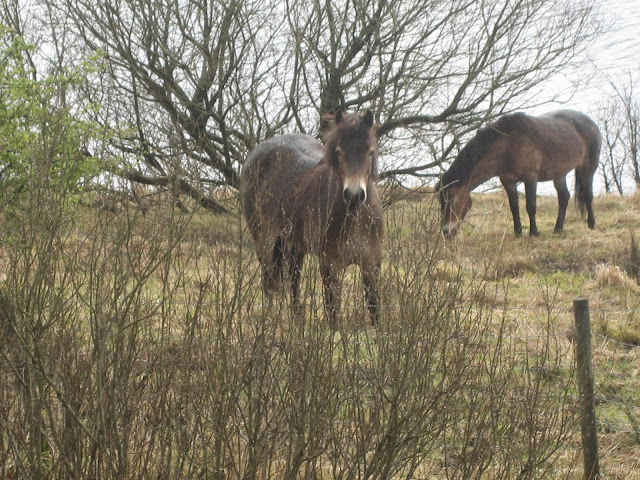
                             ..... and a nice photo of the New Forrest ponies that live nearby.


                                          The Gowans Cross, needs researching.
 The railway line crossed the river near Kielder by means of a viaduct. The railway has gone but the viaduct remains and is part of the walk. It has been decorated with wrought iron work.

                                   Two of the panels on the bridge.
 Beyond the viaduct the path leads to the village of Kielder and then up to the castle, once the Duke of Northumberland's Hunting Lodge and the official end of our walk. Fortunately the cafe and information centre was open as we had about forty five minutes to wait for the bus to take us back to Falstone, and yes it was there, on time too.
                                                     The hunting lodge at Kielder Castle, now a cafe with a screen showing live from the osprey's nest.


                                                            The Cunningham Cottage
This is another good gadgie walk, preferably in better weather but still enjoyable, especially for bird watchers. We saw;
Pied wagtails, grey wagtails,robins, wrens, blackcaps, willow warblers, goldfinches, house sparrows, buzzards, blackbirds, spotted fly catchers, herons, mallards, siskins and we heard a green woodpecker and a cuckoo.

THE MATRIX MMXV K
                                                                 steps                                  miles
LIDL 3D                                                 33007                                 14.36   generous
Hi Gear                                                   29570                                 13.4
OUTDOOR GPS                                                                               12.7
Dave's LIDL 3D                                     27049                                 12.71
Dave's USB                                             26803                                 11.84
Contains OS Data, copyright. Crown copyright and data base right 2015
and you probably realise we did the walk the other way round

Friday, 15 May 2015

The Cook, the Pies and the Topping.......May15th
  I have been looking forward to this walk for some time as it involves calling at Petch's Pies in Great Ayton to admire the selection of pastry covered delights. To reach this haven for meat eaters take the A19 south from Tyneside, turn left at the A174,turn right on to the A172 and take a minor road to Great Ayton.  Great Ayton is a pretty village, the birthplace of Captain Cook and quite obviously a well heeled settlement. The star attraction for we gadgies was Petch's Pie Shop; the window display itself was mouth watering, pork pies, steak pies, fruit pies and quiches. I bought a steak pie to take home, probably last me a week.
Six gadgies out today, Ben, Dave, Harry, Brian, John C and me.
                       
                                                   James Cook was here!
                                              But probably never had a pie from Petch's                                                                    The walk itself starts at Newton under Roseberry, a few minutes drive away.
The walk is covered by OS OL 26, North Yorks Moors Western Area and we parked at GRNZ570127. A fine car park with toilets and only £4 for a day.
A classy car park, what you would expect in this affluent area.

At the north end of the car park we turned right into Roseberry Lane which took us to a wood and the start of the climb to Roseberry Topping. There are steps of a sort to help prevent erosion and eventually they become a well made stone path that led us to the top. Roseberry Topping is a very popular local walk and the summit had a collection of hikers, walkers, picnicking young ladies and a few dogs. It has a trig point too, which has been decorated by passing walkers. It looks out over a flat agricultural area, much of it growing Rape Seed giving a yellow patchwork effect. And in the distance is the haze of Teeside and its chemical works.
                                                          The path up Roseberry Topping
                                                        The decorated trig point. No respect some people
                                                  Distant Teeside
  After a brief stop to admire the view we walked east down the hill and joined the Cleveland Way, a well  marked long distance path for walkers and mountain bikers. Chattering as we walked along nobody noticed that John was missing until we got to Highcliffe Farm. My phone rang but it was Cheryl who had got a wrong number. It rang again but I was too slow to answer. It was from John though so I called back and went straight to voice mail. Brian's turn to get a call. It was John, he had wandered off in front of us and was at the Cook Monument, several miles away and doing the walk in the opposite direction to us, or anti clarkwise as Harry said. We agreed to meet on the path later.
                                Herbie time; Mrs A spoils us with apricot flapjack. We also had Ben's biscuits, trackers and chocolate, and a sandwich.
Lunch over we headed south east along the track across the heather moor. Looking down into Sleddale we could see a cultivated area, it stood out in the otherwise bleak hills, A verdant oasis!
In one field Dave spotted a group of golden plovers which Ben had missed, strange as he is in the RSPB.
Eventually the track turns south west and then joins a metalled road. After about half a mile we turned off onto a track that curves across Great Ayton Moor. Along the way we met John walking towards us. He decided, rightly, to turn and complete the day with the rest of the team. The track, well worn by cyclists, leads down to a car park and from here a rough path took us through a conifer plantation and uphill to the James Cook Memorial.
 For foreign readers, especially those Ukrainians who have been my greatest fans this month, (thank you) James Cook was an English sailor who, skippering the ship Endeavour discovered and claimed for Britain, Australia at the back end of the 18th century. He was killed on a visit to the Sandwich Islands which then became Hawaii, the fiftieth state of the US. Cook was a brilliant cartographer too, he mapped the St. Lawrence River and the west coast of the US. He should have claimed that too.
                                    The Cook Monument
                                       The inscription to a great man and Empire Builder
Walking north from the monument we went downhill before climbing onto Great Ayton Moor again, crossing the Cleveland Way and following the path round Roseberry Topping back to the car park.

Two views of Roseberry Topping Mining took place in the 18th/19th centuries but its interesting shape was caused by the collapse of part of the hill.
We decided to hjead home for refreshment and stopped at the Cannon Inn in Earsdon near Whitley Bay. Going through the Tyne Tunnel I threw the money into the toll basket but missed. The embarrassment, perhaps I should play cricket for England. Another great gadgie day out. The birders reported lapwings, robins, chiffchaffs, stonechats, golden plovers and ravens. The stars and we heard a cuckoo, the fourth time this month being the plovers.
                                                                  Golden plover
Contains OS Data. Copyright. Crown Copyright and  Database right 2015

The Matrix  MMXV   L
                                                                                   steps                        miles


Hi gear                                                                     22792                        10.347
LIDL 3D                                                                  29920                        12.57!!!!!!!!!!!!
Dave's LIDL3D                                                       25040                        11.01
Dave's USB                                                             24231                         10.7
OUTDOORS GPS                                                                                      10.2
Brian                                                                                                            10.5
Ben                                                                                                              10.5
John C                                                                                                          10.4 but a different walk

з д р а с t у й t е   y к р а i н а