Return the Frosterley Marbles (Durham) May 10th
Frosterley is a small village in Weardale, County Durham, renowned for its marble which has been quarried for hundreds of years and used, amongst other things, as church decoration. There are no longer any quarries working. Today's walk is based on the village, the map to use is OS OL 31 North Pennines. From Newcastle take A69 west, A68 south and look out for signposts for Stanhope.
Breakfast for six at No 10 cafe in Wolsingham, and the seven are; John Ha., Brian, Ben, Harry, Dave and me. And after a week of miserable cold wet and windy weather the forecast is for a mainly dry day but cool and a light breeze at most.
Two cars, we met in the No. 10 café in Wolsingham for coffee/tea/bacon/rainbow cookies before driving the extra three miles to Frosterley.
 Number 10 in Wolsingham, highly recommended.
Frosterley has the ultimate in car parks. Not only is it free...…...…….
 …..although in Durham it is a Yorkshire car park...………..
 ...................and it has a chunk of Frosterley marble to admire....
 ……...an information pavement...…………..
 …………………………...and a mini zoo next door.
Having booted up, and gaitered in some cases we set off west along the main street. After a matter of a few hundred yards we took the road down to the station, crossed the Weardale Railway and the River Wear and headed up the road past the Primary School.
 The River Wear at Frosterley, quite dry considering the rain of the last few days.
Beyond the school we turned right and after a few hundred yards followed the sign post on the left side of the road and crossed several fields before coming to a footbridge and path that led to Pye Close Farm.
 Weathervane at Pye Close Farm. Several claimed it to be their mother in law.
After a short walk on a path beyond the farm we hit the heather. From here to our next target, Five Pikes, there are no clear paths and mostly we followed sheep tracks until we reached the trig point on the highest point .(478 metres or 1578 feet.) Pike seems a bit of a misnomer as it is fairly flat but we counted five cairns on the mini summits around. (Counting the trig point)
 Another trig point for the collection
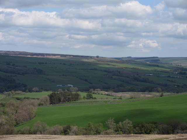
 Figures in a landscape. Looking north over Weardale from the trig point.
Leaving the trig point we headed east until we hit a gravel track. At the first grouse butt we called a Herbie and settled inside, out of the breeze for lunch.
 Dave and John sat on the floor of the butt. Knowing it would be a struggle to get up I chose to stand. We shared Ben's ginger biscuits, scones, chocolate slices, cookies and chocolate from Czechia. So good even Harry had some.
 A grouse butt. Shooters stand inside to fire their guns, dogs work as retrievers.
Lunch over we walked on the track in a north east direction for about a mile. At this point Brian and John took one track, the rest of us carried on for a short distance before turning north on a track up Harvey Hill.
We turned off the track at the sign post pointing to White Kirkley.
 Shortly after this we turned left up Harvey Hill.

 The sign post is just before the clump of trees in the middle photo.
At White Kirkley we crossed the Weardale Mineral Walk, climbed a stile on the right having crossed a bridge and followed footpaths over fields until we found ourselves in the old quarries. Although not supposed to be in there we wandered round the decaying industrial site before taking a footpath along the river to a footbridge. Over the river and the railway and we were back in Frosterley, as were the other two who had taken a slightly different route through West Biggins.
 Lime Kilns (?) on the old mineral line now the Weardale Mineral Walk
 Final footbridge....
 ……………………...and railway line which opens in summer for tourists.
Changed we headed for the Black Bull Inn near the railway station. Several ales on offer and a beautiful interior. Of the beers they had we chose Bitter and Twisted or The Wolf, both excellent too.


 The Black Bull, Frosterley, outside and inside
 Contains OS data, copyright. Crown Copyright and database right 2019
I forgot to start my GPS and haven't got Dave's pedometer readings but my humble Nakosite pedometer said 26747 steps and 9.7 miles, felt like it too.
And a few more;


Frosterley is a small village in Weardale, County Durham, renowned for its marble which has been quarried for hundreds of years and used, amongst other things, as church decoration. There are no longer any quarries working. Today's walk is based on the village, the map to use is OS OL 31 North Pennines. From Newcastle take A69 west, A68 south and look out for signposts for Stanhope.
Breakfast for six at No 10 cafe in Wolsingham, and the seven are; John Ha., Brian, Ben, Harry, Dave and me. And after a week of miserable cold wet and windy weather the forecast is for a mainly dry day but cool and a light breeze at most.
Two cars, we met in the No. 10 café in Wolsingham for coffee/tea/bacon/rainbow cookies before driving the extra three miles to Frosterley.

Frosterley has the ultimate in car parks. Not only is it free...…...…….


Having booted up, and gaitered in some cases we set off west along the main street. After a matter of a few hundred yards we took the road down to the station, crossed the Weardale Railway and the River Wear and headed up the road past the Primary School.

Beyond the school we turned right and after a few hundred yards followed the sign post on the left side of the road and crossed several fields before coming to a footbridge and path that led to Pye Close Farm.

After a short walk on a path beyond the farm we hit the heather. From here to our next target, Five Pikes, there are no clear paths and mostly we followed sheep tracks until we reached the trig point on the highest point .(478 metres or 1578 feet.) Pike seems a bit of a misnomer as it is fairly flat but we counted five cairns on the mini summits around. (Counting the trig point)


Leaving the trig point we headed east until we hit a gravel track. At the first grouse butt we called a Herbie and settled inside, out of the breeze for lunch.


Lunch over we walked on the track in a north east direction for about a mile. At this point Brian and John took one track, the rest of us carried on for a short distance before turning north on a track up Harvey Hill.
We turned off the track at the sign post pointing to White Kirkley.


At White Kirkley we crossed the Weardale Mineral Walk, climbed a stile on the right having crossed a bridge and followed footpaths over fields until we found ourselves in the old quarries. Although not supposed to be in there we wandered round the decaying industrial site before taking a footpath along the river to a footbridge. Over the river and the railway and we were back in Frosterley, as were the other two who had taken a slightly different route through West Biggins.


Changed we headed for the Black Bull Inn near the railway station. Several ales on offer and a beautiful interior. Of the beers they had we chose Bitter and Twisted or The Wolf, both excellent too.


I forgot to start my GPS and haven't got Dave's pedometer readings but my humble Nakosite pedometer said 26747 steps and 9.7 miles, felt like it too.
And a few more;


No comments:
Post a Comment