A walk from Warden to the Wall. (Northumberland) Dec 9th.
Still walking near to home as the days remain short today six of us are out walking from Warden (Weard-dun .. watchplace on the hill and the same as Warton, a village near Carnforth in Lancashire) to Hadrian's Wall, a Mithraum and several other piles of stones.
Warden is reached by taking the A69 west and turning right just beyond Hexham. The walk is covered by OS OL 43 Hadrian's Wall.
The six out today are Brian, John C., Harry, John H., Dave and me and for morning tea/coffee/bacon we stopped at Brockbushes Farm Shop at the roundabout near Corbridge. Not only do they serve good coffee and tea and an amazing looking bacon sandwich, they have a nice tractor for little boys to play on.
 Farmer Giles drives for Christmas.
We moved on to Warden and parked near the church (GR NY 913665)
It was a warm day for December, a southerly gentle wind bringing a temperature of 14C, no jacket required.


The views from the fort are well worth the climb, east across fields and the village of Wall almost to Newcastle, to the north the line of the Roman Wall.
Moving west down the hill we followed a muddy track, crossing the line of a Roman road, not that anybody noticed, and past a construction site where a new sub station was being built to feed the power from wind turbines into the national grid.

 This will not win Wildlife photographer of the year
Shortly afterwards we past the artist's cottage, complete with mysterious offerings for the Turner Prize and more worthy winners too.
 Artist' s cottage workshop?
We continued on our way west before turning south and co0ming to Newbrough Hall, a large farm with unusual outbuildings.
 Newbrough Hall
If you do this walk watch out for the finger post on the right which points to St. Peter's church. We never saw the church but we followed the path, eventually turning north east (before mile 5) and heading up a muddy track which eventually came out into fields, a suitable place for a Herbie Spot on a windfree dry day.


 Limestone Corner


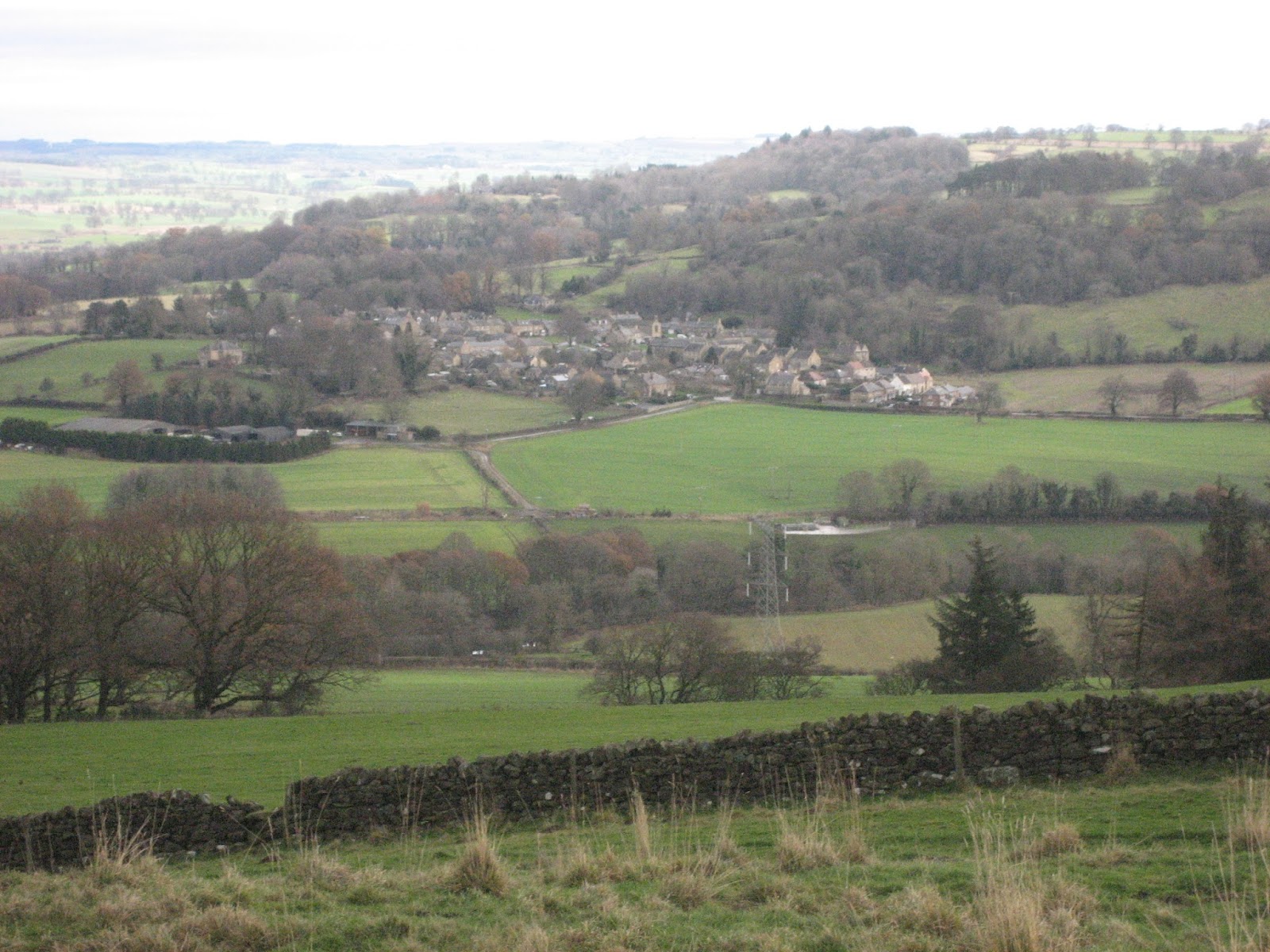
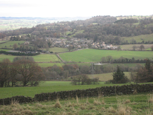 The village of Wall from the fort


 Stream near Newbrough Hall


 Info board at Mithraum; it needs replacing
 Long distance footpath marker for Hadrian's Wall Path
 Flooded ditch
 Gadgies and ditch on north side of wall

 A bit of wall.
Still walking near to home as the days remain short today six of us are out walking from Warden (Weard-dun .. watchplace on the hill and the same as Warton, a village near Carnforth in Lancashire) to Hadrian's Wall, a Mithraum and several other piles of stones.
Warden is reached by taking the A69 west and turning right just beyond Hexham. The walk is covered by OS OL 43 Hadrian's Wall.
The six out today are Brian, John C., Harry, John H., Dave and me and for morning tea/coffee/bacon we stopped at Brockbushes Farm Shop at the roundabout near Corbridge. Not only do they serve good coffee and tea and an amazing looking bacon sandwich, they have a nice tractor for little boys to play on.

We moved on to Warden and parked near the church (GR NY 913665)
It was a warm day for December, a southerly gentle wind bringing a temperature of 14C, no jacket required.

St. Michael's Warden, the tower is Saxon, the rest is pretty old too

Yorkshire car park on the side of the road near the church in Warden.
Booted up we headed north on the road out of Warden. After climbing uphill for a short time we turned left off the road and heade3d up the path to High Warden and from there across fields to the Iron Age fort on Warden Hill. Somewhere in this area the first real Boy Scout camp was held in 1907, after the "gathering" on Brownsea Island.The views from the fort are well worth the climb, east across fields and the village of Wall almost to Newcastle, to the north the line of the Roman Wall.
Moving west down the hill we followed a muddy track, crossing the line of a Roman road, not that anybody noticed, and past a construction site where a new sub station was being built to feed the power from wind turbines into the national grid.

Power for the people
Beyond the site we turned left on the road and then right shortly afterwards. A footpath on the left (mile 3) took us across fields and between plantations. Two deer burst out of the plantation on the right, leaping fences like Grand National runners, but a third took some time to cross. By the time I had my camera out it was nearly gone.
Shortly afterwards we past the artist's cottage, complete with mysterious offerings for the Turner Prize and more worthy winners too.

We continued on our way west before turning south and co0ming to Newbrough Hall, a large farm with unusual outbuildings.

If you do this walk watch out for the finger post on the right which points to St. Peter's church. We never saw the church but we followed the path, eventually turning north east (before mile 5) and heading up a muddy track which eventually came out into fields, a suitable place for a Herbie Spot on a windfree dry day.

Herbie time; fruit cake, mince pies, Yorkshire flapjacks and Eat Naturally, a variation on a Beatles song, although not penned by Lennon and McCartney. You can tell what a pleasant day it was. And all the rubbish was taken away.
After lunch we headed north across the fields before turning left to visit the Mithraum.
The Mithraum is the remains of a Roman temple to Mithras, a deity originating in Persia but very popular with the legions. There is a reconstruction in Newcastle Great North Museum and the original altar stones are there too. The ones in the temple here are good reproductions.


This altar stone is cut through to allow for a light to give the god a halo effect. If you want to learn more about the archaeology of the Roman wall find "Future Learn" and sign up for their course on Hadrian's construction when it is repeated.
From here (mile 7) we headed east along the Hadrian's Wall path. Most of this section is on the north side of the wall, parallel to the ditch, the wall itself being under the road!

The ditch on the north side of the wall.
The path here crosses "limestone corner" where the Roman engineers failed to break or move the rocks which are not limestone anyway, but dolorite on the Whin Sill.


Limestone corner where the workers finally gave up on the ditch and told Hadrian to dig it himself.
The black lines are where they tried to cut into the rock but it was too hard. Supposedly.
After a mile and a half on the Wall Path we crossed the road, walked through muddy fields to Walwick Field and on reaching the road followed it south, turning left at the junction, passing the sub station site again. rather than walk over the hill with the Iron Age fort again we took the footpath round it, crossed several fields until we hit the narrow path alongside the Newcastle - Carlisle railway.
By this time it was dark, the path was narrow and nobody had a torch of course, but we stumbled back to the cars, changed and went to the Warden pub/hotel, The Boatside. Very welcoming.Winston and Isa from Still Game sat at the bar which served White hot and Monument Ales, and tea.
Another good walk, but 99% of gadgie walks are. It is a bit on the long side for a short day in winter, either start early or do it in summer. Not much climbing, lots to see and a good pub at the end.


Both maps contain OS data copyright. Crown copyright and database right 2016The black lines are where they tried to cut into the rock but it was too hard. Supposedly.
After a mile and a half on the Wall Path we crossed the road, walked through muddy fields to Walwick Field and on reaching the road followed it south, turning left at the junction, passing the sub station site again. rather than walk over the hill with the Iron Age fort again we took the footpath round it, crossed several fields until we hit the narrow path alongside the Newcastle - Carlisle railway.
By this time it was dark, the path was narrow and nobody had a torch of course, but we stumbled back to the cars, changed and went to the Warden pub/hotel, The Boatside. Very welcoming.Winston and Isa from Still Game sat at the bar which served White hot and Monument Ales, and tea.
Another good walk, but 99% of gadgie walks are. It is a bit on the long side for a short day in winter, either start early or do it in summer. Not much climbing, lots to see and a good pub at the end.


The Matrix MMXVI penultimate possibly
steps miles
NAK 35829 14.7
Dave's 3D 28865 13.28
"" USB 28031 13.27
"" NAK 27590 13.06
Etrx GPS 13.5
OUTDOOR GPS 13
iPhone 30307 13.4
John C GPS 13.5
Brian GPS 13.15 (right?)
steps miles
NAK 35829 14.7
Dave's 3D 28865 13.28
"" USB 28031 13.27
"" NAK 27590 13.06
Etrx GPS 13.5
OUTDOOR GPS 13
iPhone 30307 13.4
John C GPS 13.5
Brian GPS 13.15 (right?)
No comments:
Post a Comment