EDlingham, not EGlingham.......August 31
A word of warning; this walk is very muddy in places, furthermore we have done it before, (Brian's Round; Dec 9th) but as I feel committed to my readers I shall describe it again.
There are four of us out today, Routemeister, vogelmeister, musicmeister, who is becoming a regular, and blogpiemeister.
The two villages of Edlingham and Eglingham are not too far apart, especially if you are a crow, so make sure you find the right one. Edlingham is reached from Newcastle by taking the now familiar A1 north, turning onto the A697 north of Morpeth and turning right onto the B6341 which is signposted Alnwick. After about three miles turn left into Edlingham. Turn right towards the church and there is some limited parking on the roadside.
A map is very useful for this walk and it, and Eglingham too if you have made a mistake, is covered by OS Explorer 332 1:25000. The church at Edlingham is at GR114091.
Edlingham is the modernised version of Eadwulfincham, meaning, in Old English "Eadwulf's peoples homestead". It gets a first mention in 737 when KingCeowulf decided to become a monk and gave four of his villages to the monks of Lindisfarne.
The village church, dedicated to St. John the Baptist, has origins in the 11th century although it is thought it could stand on an even older building.

St. John the Baptist church at Edlingham. It has a flat roof but the weather moulding on the east side of the tower suggest there was a pitched roof at one time. Confusingly the leaflet available in the church mentions the "massive oak roof timbers.........the only remaining part of the medieval flat roof." It is a squat building, doubling as a defensive place to hide from marauding Scots.
The fine stained glass window at the east end of the church dates from as long ago as 1864.
 St. John the Baptist Church Interior.
East of the church are the ruins of Edlingham Castle, dating from the 13th century and once a substantial stronghold.
 A sketch of the castle at Edlingham and a plan of the buildings. I confess I have pinched these from the informative leaflet available in the church at Edlingham. The illustrations are by John Smith. and I hope he doesn't sue for copyright. Put it this way, the blog could attract more visitors and sell more leaflets. (50p well worth it too.)
The walk:
Leave the church and walk up the lane, continue along the road through the village, which has no shop or pub if you want to make a day out. However on August 31st the blackberries growing on the south facing side of the road were ripe and delicious, instant vitamin C.
After the last building on the left follow the sign post which leads to a path heading south across fields. Part of this footpath goes on the top of a Roman road, called the Devil's Causewy today but probably the MXIX in Roman times.
As one we cried, "What did the Romans ever do for us ?" * and continued on our way down the hill. The edging stones on the path could be original Roman for all I know. At the bottom of the hill there is a choice of ford or footbridge to cross the Edlingham Burn. We used the bridge and climbed the short distance to the road. ((B6341)
Across the road a gate, with marker, takes you to a good grassy which meanders slightly south then east until it joins the official footpath and stops at the edge of Edlingham Woods.
Take care, or like us, you will go wrong. A forest track inside the gate looks inviting but it will take you to Bigges Pillar, well out of the way. (See the spike on the map below.) Bigges Pillar is a large stone construction, possibly a medieval beacon.
Instead look for the footpath on the right just inside the gate. It is not too obvious but with the aid of a machete you will eventually find yourself at Wellhope, a cottage with a few outhouses. The family who live here used to occupy a teepee, perhaps they prefer a few more comforts now. Follow the fence by the house and eventually you should come to the edge of the wood. We missed the path again and finished up emerging from the wood a little higher than the path marked on the map and thus missing the cup and ring marked rocks. However I did a short detour through a gate to look at the basketball net which turned out to be the "Glantlees Watch Tower". Fixed to it was a poem, written a la MacGonagal, telling the tale of young Rowle who, realising a band of Scots were marauding, ran to save his master in the Glantlees Peel..
A well constructed concrete track took us down almost to Snook Bank farm where we turned left and walked on a few yards to a ford which made an excellent Herbiespot. You guessed, sandwiches and pork pies!
The footpath continues across a couple of fields before it reaches a sheltered track going to Glantlees.
The fields had a small herd of bullocks, less one who appeared to be still fully equipped. They gathered round the gate but soon cleared off when we called "mustard", a variation on an old Ken Dodd joke.**


A word of warning; this walk is very muddy in places, furthermore we have done it before, (Brian's Round; Dec 9th) but as I feel committed to my readers I shall describe it again.
There are four of us out today, Routemeister, vogelmeister, musicmeister, who is becoming a regular, and blogpiemeister.
The two villages of Edlingham and Eglingham are not too far apart, especially if you are a crow, so make sure you find the right one. Edlingham is reached from Newcastle by taking the now familiar A1 north, turning onto the A697 north of Morpeth and turning right onto the B6341 which is signposted Alnwick. After about three miles turn left into Edlingham. Turn right towards the church and there is some limited parking on the roadside.
A map is very useful for this walk and it, and Eglingham too if you have made a mistake, is covered by OS Explorer 332 1:25000. The church at Edlingham is at GR114091.
Edlingham is the modernised version of Eadwulfincham, meaning, in Old English "Eadwulf's peoples homestead". It gets a first mention in 737 when KingCeowulf decided to become a monk and gave four of his villages to the monks of Lindisfarne.
The village church, dedicated to St. John the Baptist, has origins in the 11th century although it is thought it could stand on an even older building.

St. John the Baptist church at Edlingham. It has a flat roof but the weather moulding on the east side of the tower suggest there was a pitched roof at one time. Confusingly the leaflet available in the church mentions the "massive oak roof timbers.........the only remaining part of the medieval flat roof." It is a squat building, doubling as a defensive place to hide from marauding Scots.
The fine stained glass window at the east end of the church dates from as long ago as 1864.

East of the church are the ruins of Edlingham Castle, dating from the 13th century and once a substantial stronghold.

The walk:
Leave the church and walk up the lane, continue along the road through the village, which has no shop or pub if you want to make a day out. However on August 31st the blackberries growing on the south facing side of the road were ripe and delicious, instant vitamin C.
After the last building on the left follow the sign post which leads to a path heading south across fields. Part of this footpath goes on the top of a Roman road, called the Devil's Causewy today but probably the MXIX in Roman times.
As one we cried, "What did the Romans ever do for us ?" * and continued on our way down the hill. The edging stones on the path could be original Roman for all I know. At the bottom of the hill there is a choice of ford or footbridge to cross the Edlingham Burn. We used the bridge and climbed the short distance to the road. ((B6341)
Across the road a gate, with marker, takes you to a good grassy which meanders slightly south then east until it joins the official footpath and stops at the edge of Edlingham Woods.
Take care, or like us, you will go wrong. A forest track inside the gate looks inviting but it will take you to Bigges Pillar, well out of the way. (See the spike on the map below.) Bigges Pillar is a large stone construction, possibly a medieval beacon.
Instead look for the footpath on the right just inside the gate. It is not too obvious but with the aid of a machete you will eventually find yourself at Wellhope, a cottage with a few outhouses. The family who live here used to occupy a teepee, perhaps they prefer a few more comforts now. Follow the fence by the house and eventually you should come to the edge of the wood. We missed the path again and finished up emerging from the wood a little higher than the path marked on the map and thus missing the cup and ring marked rocks. However I did a short detour through a gate to look at the basketball net which turned out to be the "Glantlees Watch Tower". Fixed to it was a poem, written a la MacGonagal, telling the tale of young Rowle who, realising a band of Scots were marauding, ran to save his master in the Glantlees Peel..
A well constructed concrete track took us down almost to Snook Bank farm where we turned left and walked on a few yards to a ford which made an excellent Herbiespot. You guessed, sandwiches and pork pies!
The footpath continues across a couple of fields before it reaches a sheltered track going to Glantlees.
The fields had a small herd of bullocks, less one who appeared to be still fully equipped. They gathered round the gate but soon cleared off when we called "mustard", a variation on an old Ken Dodd joke.**

They moved on the cry "Mustard", looking very worried.
Immediately after Glantlees a footpath goes through two gates with markers as it crosses fields until it comes to a minor road. Turn left and walk along the road through Shiel Dykes, past a small artificial pond on the left which is used for fishing. Beyond the pond is a stretch of what is possibly an 17th century boundary wall. Basically a stone bank.

Not a wall, a stone bank, serving as boundary and fence.
Shortly after going through a gate there is a footpath, with marker, on the left which leads past Phyllis's Plantation and Stirkhill Plantation. This is the really muddy part of the walk. The fields, especially round the gates, have been churned up by cattle and the recent rains have produced a bog. Wellingtons may be more useful than boots round here but nobly we struggled on uphill. The mess the animals make is a strong argument for the world becoming vegetarian. And if it isn't mud it's the grass. Uneaten and long, it is harder to walk through than soft snow or sand. WE must be getting old. On the ridge ahead is a tatty line of hawthorns. Aim for the one on the right and close by is a gate, at Mares Rigg, with marker, than takes you to a path across a heather moor and then alongside Well Hope Wood. At the bottom is a gate and you are back on the B6341. Turn right and after a few hundred yards turn left on the road into Edlingham.
On the road back there is a fine view of the third piece of architectural interest Edlingham has to offer: the viaduct on the dismantled railway.
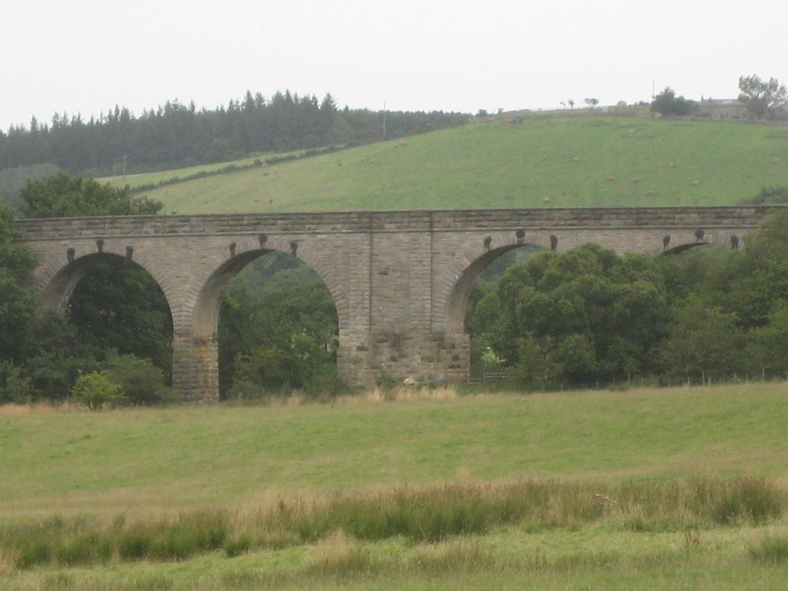
Edlingham Viaduct, a word given us by the Romans, so that's what they did for us!
There is no public right of way on it. Shame.
Changed into apres walk gear we headed for the good old Anglers Arms at Weldon Bridge which had Ruddles County, Abbot Ale and Timothy Taylor's Golden Best on offer.And I wasn't driving!
MATRIX LVI
steps miles
ASDAped 8922 4.22 obviously something wrong
LIDLUSB 24865 11.77
HIGEAR 23880 10.84
USB 11.3
MEASURED ON MAP 11.1
I do not think this walk will be done again, too much mud.

Edlingham is in the top left hand corner, I missed it on the scan but I am getting better. Note the spike that goes to Bigges Pillar and don't go that way.
* A line from Monty Python's Life of Brian.
** Ken Dodd, very funny Liverpudlian comedian who worried sheep by shouting "Mint Sauce" He also had one of the best selling pop singles in British Music History. Outselling groups like the Beatles his record was "Tears" and it caused quite a few.
No comments:
Post a Comment