Convents and Causeways... September 18th
If this is a gadgie walk it should be Friday, but it isn't. It's Tuesday and today Dave the vogelmeister and I are having an extra walk out. Although we said we would never do the Edlingham walk again we have had a slight change of heart and are doing a walk of interest starting from the church of St. John the Baptist. To get to Edlingham take the A1, A697, turn right onto the B6341 and turn left into the village. Turn right and park near the church.
We set off up the lane from the church and continued uphill a short way before finding a signpost on the right directing us to Birsley Woods. The walk is well signed and after crossing two fields we walked along the outside of the wood before heading diagonally in a north west direction to Birsley Woodside Farm.
 I do not know what offence this crow had committed but he/she was
executed on the edge of Birsley Wood. Country ways!
Turning right on the road we walked a few hundred yards before spottting the marker on the left and walking westwards across a field before turning north west on the Devil's Causeway, a Roman road.
The line of the road is quite clear, cut into the slope of the land, although it would be necessary to dig down to find evidence of the stone base. The road continued across two fields and in the north west corner of the second we crossed, with the aid of some wobbly stepping stones, a small stream and headed towards High Learchild Farm. Before reaching the farm our path turned north across two fields until we reached the embankment of a dismantled railway.
(The correct route is to turn right about 200 yards into the field from the stream and head slightly east of north until you come to the track leading to the crossing cottage)
On the embankment we turned east and followed the old line until we came to the crossing cottage)

The old railway line, Beechinged!
At the cottage we turned left along a good farm road. On the right hand side of the road, in the first field is the site of Learchild Roman Fort. There is nothing to be seen unless you are in the air, from where you can see the outline of the fort. In this area two Roman roads met, so the fort had some significance at the Roman equivalent of Spaghetti Junction.*
At the end of the farm road we turned right onto a minor road leading to Alnwick. Probably the worst part of the walk as the road does not have a footpath and is quite busy. We crossed one junction and at the next a signpost on the right directed us across a field to Battle Bridge Farm. Passing through the farm yard we followed the path downhill to a footbridge across the Edlingham Burn and declared the sunny field on the south side of the stream a Herbiespot. After the usual pies and sandwiches we continued up the side of the ploughed field and found in the south east corner a gate leading to Lemmington Hall. However we decided to save the hall for later and turned left past its pretty little brick built Garden Cottage. At the first junction we turned left and at the next, back on the road we turned right and walked for about a half mile to Broome Wood. Opposite the farm building a gated path took us past the Keeper's Cottage and across a field beneath the Lemmington Branch.

Lemmington Branch, an 18th century hilltop eyecatcher.
We followed the markers across two fields before entering Lemmington Woods. Almost the first thing to be seen in the wood was the "Paradise Stone"
.jpg) The word "Paradise " is carved into the stone. Some fittings have been stripped from it. Anybody
The word "Paradise " is carved into the stone. Some fittings have been stripped from it. Anybody
knowing more about it, please let me know.
Emerging from the wood we saw an old railway bridge on the left but turned right and after a few hundred yards found a gate with a notice saying that the fields on the left, with Lemmington Hall at the far end were Open Access Land and we were welcome to cross them.
In the field, and hardly missable we came to a large standing stone with "I will lift up mine eyes unto the hills" engraved on it. Very suitable as beyond the stone in the distance the Cheviot range was clearly visible.
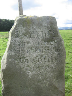 From whence cometh my help.
 Distant Cheviots
Near the stone is a column, designed by Sir John Soane, Built in the 18th Century a memorial to James Evelyn, a relative of the diarist John Evelyn. Originally sited in Felbridge Park Surrey it was brought to the north as an ornament in 1928. On its base is a carving of a self swallowing serpent, a symbol of eternity.
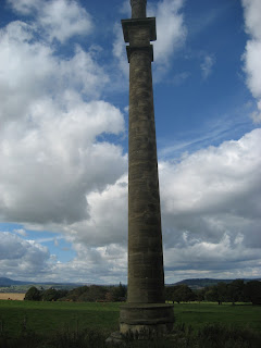 James Evelyn's Memorial Column,
engraved with verses.
Also in the field were several memorial stones, carved with initials and a beetle. The hall was owned in the 1920 by Sir Stephen Aitchison which probably explains why the last initial on each stone was an A.
And at the bottom of the field is the hall itself. Built in the 18th century, roofless and ruined by the end of the 19th it was restored in 1913 for the above mentioned Sir Stephen. It is now a convent.
 Lemmington Hall, now a convent but looking like the ideal spot for some of
Jane Austen's maidens to swoon behind their fans as D'arcy walked by.
Also in the fields by the hall was a fine example of possibly medieval "Ridge and furrow" The ridges are so high and the furrows so deep they could have been left like this from their last ploughing, the fields simply being pasture.
 Ridged and furrowed, medieval farming. No John Deeres then.
And visible from the fields we could see the Combine Harvester Scrap yard. A field full of combines, some old, some quite new. A local had the bright idea of collecting them, stripping them and selling parts as spares. Apparently his does business world wide. I am told a new combine cost £250000 so looking mout for spares makes sound sense. Why put a John Deere or Claahs down when you can repair it!
 A distant view of the combine graveyard. I need a papparazi style camera really, or I could go nearer.
Near the south west corner of the hall grounds we found the gate leading to a track for Lemmington Mill. However we followed the signpost pointing towards Edlingham and crossed several fields before coming to a footbridge crossing Corby's Letch.** Two more fields and Edlingham viaduct and Castle were before us. A ruin of a 13th century castle which grew from a relatively small one to a splendid edifice before being abandoned. A part of the castle leans, but is tied into the main tower. It is suggested that the later addition was built over the castle moat and overtime it settled, Pisa like. Close by the Victorian viaduct across the Edlingham burn.
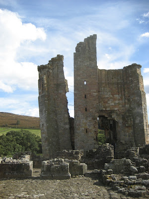
The leaning tower of Edlingham. Look carefully and you can see the steel bars
holding it to the main building.

Edlingham viaduct.
And finally back to the church of St. John the Baptist, started in the 11th century. In the grave yard I spotted a headstone to the four daughters of a local couple. Three of the children, aged 6, 5 and 2 had died within days of each other in April 1848. The fourth had survived to old age. Typhoid ? Cholera?
Inside the church I spotted a table covered with books and an invitation to buy. There was a copy of John Evelyn's diary, volume 2. It seemed appropriate, so I made a donation and took the book.
This was a walk with a difference, designed in part to look at buildings of interest, and as such it was very successful, a great day out.
The Matrix
steps miles
Higear 15519 7.045
Little black 11941 5.18
LIDLUSB 18760 8.88
Outdoors GPS 8.2 miles
Measured 8 miles
A poor day for pedometers!!!!!!!!!!

Contains OS data Copyright. Crown copyright and data base right 2012
* For my overseas readers Spaghetti Junction is the popular name for Gravelly Hill intersection on motorways near Birmingham.
**Letch North Eastern word for a ditch or gutter.
If this is a gadgie walk it should be Friday, but it isn't. It's Tuesday and today Dave the vogelmeister and I are having an extra walk out. Although we said we would never do the Edlingham walk again we have had a slight change of heart and are doing a walk of interest starting from the church of St. John the Baptist. To get to Edlingham take the A1, A697, turn right onto the B6341 and turn left into the village. Turn right and park near the church.
We set off up the lane from the church and continued uphill a short way before finding a signpost on the right directing us to Birsley Woods. The walk is well signed and after crossing two fields we walked along the outside of the wood before heading diagonally in a north west direction to Birsley Woodside Farm.

executed on the edge of Birsley Wood. Country ways!
Turning right on the road we walked a few hundred yards before spottting the marker on the left and walking westwards across a field before turning north west on the Devil's Causeway, a Roman road.
The line of the road is quite clear, cut into the slope of the land, although it would be necessary to dig down to find evidence of the stone base. The road continued across two fields and in the north west corner of the second we crossed, with the aid of some wobbly stepping stones, a small stream and headed towards High Learchild Farm. Before reaching the farm our path turned north across two fields until we reached the embankment of a dismantled railway.
(The correct route is to turn right about 200 yards into the field from the stream and head slightly east of north until you come to the track leading to the crossing cottage)
On the embankment we turned east and followed the old line until we came to the crossing cottage)

The old railway line, Beechinged!
At the cottage we turned left along a good farm road. On the right hand side of the road, in the first field is the site of Learchild Roman Fort. There is nothing to be seen unless you are in the air, from where you can see the outline of the fort. In this area two Roman roads met, so the fort had some significance at the Roman equivalent of Spaghetti Junction.*
At the end of the farm road we turned right onto a minor road leading to Alnwick. Probably the worst part of the walk as the road does not have a footpath and is quite busy. We crossed one junction and at the next a signpost on the right directed us across a field to Battle Bridge Farm. Passing through the farm yard we followed the path downhill to a footbridge across the Edlingham Burn and declared the sunny field on the south side of the stream a Herbiespot. After the usual pies and sandwiches we continued up the side of the ploughed field and found in the south east corner a gate leading to Lemmington Hall. However we decided to save the hall for later and turned left past its pretty little brick built Garden Cottage. At the first junction we turned left and at the next, back on the road we turned right and walked for about a half mile to Broome Wood. Opposite the farm building a gated path took us past the Keeper's Cottage and across a field beneath the Lemmington Branch.

Lemmington Branch, an 18th century hilltop eyecatcher.
We followed the markers across two fields before entering Lemmington Woods. Almost the first thing to be seen in the wood was the "Paradise Stone"
.jpg)
knowing more about it, please let me know.
Emerging from the wood we saw an old railway bridge on the left but turned right and after a few hundred yards found a gate with a notice saying that the fields on the left, with Lemmington Hall at the far end were Open Access Land and we were welcome to cross them.
In the field, and hardly missable we came to a large standing stone with "I will lift up mine eyes unto the hills" engraved on it. Very suitable as beyond the stone in the distance the Cheviot range was clearly visible.


Near the stone is a column, designed by Sir John Soane, Built in the 18th Century a memorial to James Evelyn, a relative of the diarist John Evelyn. Originally sited in Felbridge Park Surrey it was brought to the north as an ornament in 1928. On its base is a carving of a self swallowing serpent, a symbol of eternity.

engraved with verses.
Also in the field were several memorial stones, carved with initials and a beetle. The hall was owned in the 1920 by Sir Stephen Aitchison which probably explains why the last initial on each stone was an A.
And at the bottom of the field is the hall itself. Built in the 18th century, roofless and ruined by the end of the 19th it was restored in 1913 for the above mentioned Sir Stephen. It is now a convent.

Jane Austen's maidens to swoon behind their fans as D'arcy walked by.
Also in the fields by the hall was a fine example of possibly medieval "Ridge and furrow" The ridges are so high and the furrows so deep they could have been left like this from their last ploughing, the fields simply being pasture.

And visible from the fields we could see the Combine Harvester Scrap yard. A field full of combines, some old, some quite new. A local had the bright idea of collecting them, stripping them and selling parts as spares. Apparently his does business world wide. I am told a new combine cost £250000 so looking mout for spares makes sound sense. Why put a John Deere or Claahs down when you can repair it!

Near the south west corner of the hall grounds we found the gate leading to a track for Lemmington Mill. However we followed the signpost pointing towards Edlingham and crossed several fields before coming to a footbridge crossing Corby's Letch.** Two more fields and Edlingham viaduct and Castle were before us. A ruin of a 13th century castle which grew from a relatively small one to a splendid edifice before being abandoned. A part of the castle leans, but is tied into the main tower. It is suggested that the later addition was built over the castle moat and overtime it settled, Pisa like. Close by the Victorian viaduct across the Edlingham burn.

The leaning tower of Edlingham. Look carefully and you can see the steel bars
holding it to the main building.

Edlingham viaduct.
And finally back to the church of St. John the Baptist, started in the 11th century. In the grave yard I spotted a headstone to the four daughters of a local couple. Three of the children, aged 6, 5 and 2 had died within days of each other in April 1848. The fourth had survived to old age. Typhoid ? Cholera?
Inside the church I spotted a table covered with books and an invitation to buy. There was a copy of John Evelyn's diary, volume 2. It seemed appropriate, so I made a donation and took the book.
This was a walk with a difference, designed in part to look at buildings of interest, and as such it was very successful, a great day out.
The Matrix
steps miles
Higear 15519 7.045
Little black 11941 5.18
LIDLUSB 18760 8.88
Outdoors GPS 8.2 miles
Measured 8 miles
A poor day for pedometers!!!!!!!!!!

Contains OS data Copyright. Crown copyright and data base right 2012
* For my overseas readers Spaghetti Junction is the popular name for Gravelly Hill intersection on motorways near Birmingham.
**Letch North Eastern word for a ditch or gutter.
No comments:
Post a Comment