Hedgehope January 20th
When I came to the North East of England the first walk I went on was up Hedgehope Hill. I remember it well; it was a Sunday in January 1965 and it was snowing. A bus load of students were taken to Langleeford and set off up the hill. It was a cold day, Ian Dixon and I decided the best thing to do was get up there, get down and get to Wooler as quickly as possible for some beer. We got up there, got down and made it into Wooler by 1.50pm and managed a couple of pints. It is well worth pointing out that in those days pubs were only allowed to open on Sunday lunchtimes from 12 till 2pm.
I have been up Hedgehope many times since then; it is a pretty hill, from some quarters it looks cone shaped like a child's drawing of a hill, quite unlike the plateau of its slightly higher neighbour the Cheviot. One day in late summer us gadgies saw a family of peregrines playing in the sky on the summit, another time, in pre-gadgie days four of us sheltered on a cold winter's day in an igloo shaped contraption that Brian had. We just pulled the hemisphere over ourselves and body heat and breathing kept it in shape and kept us warm. Enough, today six gadgies, the regular team, are going to walk up Hedgehope from Langleeford, usually we go from Hartside in the Breamish Valley but variety and all that. For directions to Langleeford see post The Henhole a favourite gadgie walk. I can't find any explanation for the name Hedgehope; hope in this case means a narrow valley, which the Harthope Valley is but the hill lies between this valley and the wider Breamish (or Ingram) Valley.
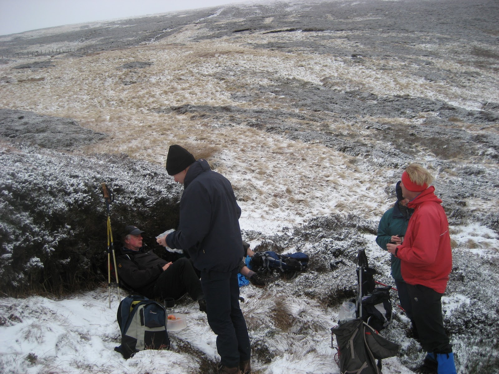
No matter, we six left the grassy parking area, turned left and headed up the Harthope Burn, passing first the farm at Langleeford with its impressive new bridge through the delightfully named "Cat Loup" and at the end of the track passing Langleeford Hope, the last building in the valley and by all appearances a holiday cottage. The track now becomes a footpath, continuing alongside the stream but frequently crossing it, not always easy, some of the stepping stones being slippy with moss or ice. The path climbs steadily, passing Harthope Linn, a pretty waterfall and something we all managed to miss today. Eventually at a point near Scotsman's Knowe we declared a Herbiehalt. (On OL16 this unmarked Herbiehalt is at GR906191).
Hunkered* down out of the wind the pies were passed round, Halfmarathon meister Ben offered home made ginger biscuits and conversation flowed with the hot coffee.
Dave mentioned that ten days ago some of us had been in Gosforth Park Nature Reserve and had seen, amongst other birds, a rather handsome bittern. Dave had returned some days later but there was no bittern in the reeds. "Once bittern, twice shy!" quipped the punmeister. A good one I thought, with the promise of more to come.

Lunch break near Scotsman's Knowe. Actually nobody is hunkered down in this picture but there is a hint of snow.
Lunch over, it's back on your heads and turning through almost 180 degrees we crossed a fence and set out on the footpath for Comb Fell and Hedgehope beyond. It began to snow, lightly, but undeterred we plodded on, with the wind at our backs, unlike the only other people we met, a couple going in the opposite direction. We agreed it was a nice day out for a walk.

This view of Hedgehope was taken from the Herbiehalt, skies darkening and snow beginning to fall.

Ray, me, Brian, Harry and Ben on top of old Hedgie. Dave took the photo, practising for the day he gets his camera out of the box.
There is a well built shelter on the top of Hedgehope, usually a good Herbiespot and affording views of the hills on three sides and the distant coast. On a really good day you can see Blyth** from here. Having worked there for thirty years I make no comment. From the top of Hedgehope the path heads slightly east of north down a steep slope, gently curving more to the east until it comes to an outcrop called Long Crags. It goes through the crags and to the left of Housey Crags where the archaegadgie identified an ancient settlement and homestead. Continuing down the path we soon came to a footbridge over Harthope Burn and back to the cars.
Not surprisingly we stopped to rehydrate at the Anglers Arms pub, Weldon Bridge. Timothy Taylor's Landlord was on offer and some took it, but driving again I had tea. Brian entertained us, his worst effort being that he had called his pet lizard tiny because it was minute. The rest of the jokes are not fit for publication here.
However, a breakthrough in forward planning; next week's gadgie walk will be on the North Yorkshire Moors. No need for last minute emails, phone calls and questions. Of course if it rains it could be a Railway walk. An even better idea was to have a walk,book in to the Anglers Arms, have dinner and drink beer all night, going home the next day. Sounds good to me.
There was the usual variations on distance walked:
Two Ped Dave said 8.72 miles or 10.05 miles
The Bragometer (Ben) said 9.3 miles.
Higear said 10.39 miles but I would blame that on short steps going up the steep valley and Hedgehope.
The Outdoors app, bought at considerable expense and ably assisted by the " mophie juice pack" which extends battery life came in at 8.7 miles and it drew a map! Curiously it claimed we gained more height than we lost, by a considerable amount too. can somebody explain.
Measured on the map the walk was 8.7 miles. I think 9 will do.
* Hunkers a phrase used in the days of mining to describe the way miners squatted "with the hams resting on the calves of the legs"
** Blyth; small coastal town, once famous for mining, exporting coal and building ships. Approximately forty miles away from Hedgehope.
When I came to the North East of England the first walk I went on was up Hedgehope Hill. I remember it well; it was a Sunday in January 1965 and it was snowing. A bus load of students were taken to Langleeford and set off up the hill. It was a cold day, Ian Dixon and I decided the best thing to do was get up there, get down and get to Wooler as quickly as possible for some beer. We got up there, got down and made it into Wooler by 1.50pm and managed a couple of pints. It is well worth pointing out that in those days pubs were only allowed to open on Sunday lunchtimes from 12 till 2pm.
I have been up Hedgehope many times since then; it is a pretty hill, from some quarters it looks cone shaped like a child's drawing of a hill, quite unlike the plateau of its slightly higher neighbour the Cheviot. One day in late summer us gadgies saw a family of peregrines playing in the sky on the summit, another time, in pre-gadgie days four of us sheltered on a cold winter's day in an igloo shaped contraption that Brian had. We just pulled the hemisphere over ourselves and body heat and breathing kept it in shape and kept us warm. Enough, today six gadgies, the regular team, are going to walk up Hedgehope from Langleeford, usually we go from Hartside in the Breamish Valley but variety and all that. For directions to Langleeford see post The Henhole a favourite gadgie walk. I can't find any explanation for the name Hedgehope; hope in this case means a narrow valley, which the Harthope Valley is but the hill lies between this valley and the wider Breamish (or Ingram) Valley.
No matter, we six left the grassy parking area, turned left and headed up the Harthope Burn, passing first the farm at Langleeford with its impressive new bridge through the delightfully named "Cat Loup" and at the end of the track passing Langleeford Hope, the last building in the valley and by all appearances a holiday cottage. The track now becomes a footpath, continuing alongside the stream but frequently crossing it, not always easy, some of the stepping stones being slippy with moss or ice. The path climbs steadily, passing Harthope Linn, a pretty waterfall and something we all managed to miss today. Eventually at a point near Scotsman's Knowe we declared a Herbiehalt. (On OL16 this unmarked Herbiehalt is at GR906191).
Hunkered* down out of the wind the pies were passed round, Halfmarathon meister Ben offered home made ginger biscuits and conversation flowed with the hot coffee.
Dave mentioned that ten days ago some of us had been in Gosforth Park Nature Reserve and had seen, amongst other birds, a rather handsome bittern. Dave had returned some days later but there was no bittern in the reeds. "Once bittern, twice shy!" quipped the punmeister. A good one I thought, with the promise of more to come.
Lunch break near Scotsman's Knowe. Actually nobody is hunkered down in this picture but there is a hint of snow.
Lunch over, it's back on your heads and turning through almost 180 degrees we crossed a fence and set out on the footpath for Comb Fell and Hedgehope beyond. It began to snow, lightly, but undeterred we plodded on, with the wind at our backs, unlike the only other people we met, a couple going in the opposite direction. We agreed it was a nice day out for a walk.

This view of Hedgehope was taken from the Herbiehalt, skies darkening and snow beginning to fall.

Ray, me, Brian, Harry and Ben on top of old Hedgie. Dave took the photo, practising for the day he gets his camera out of the box.
There is a well built shelter on the top of Hedgehope, usually a good Herbiespot and affording views of the hills on three sides and the distant coast. On a really good day you can see Blyth** from here. Having worked there for thirty years I make no comment. From the top of Hedgehope the path heads slightly east of north down a steep slope, gently curving more to the east until it comes to an outcrop called Long Crags. It goes through the crags and to the left of Housey Crags where the archaegadgie identified an ancient settlement and homestead. Continuing down the path we soon came to a footbridge over Harthope Burn and back to the cars.
Not surprisingly we stopped to rehydrate at the Anglers Arms pub, Weldon Bridge. Timothy Taylor's Landlord was on offer and some took it, but driving again I had tea. Brian entertained us, his worst effort being that he had called his pet lizard tiny because it was minute. The rest of the jokes are not fit for publication here.
However, a breakthrough in forward planning; next week's gadgie walk will be on the North Yorkshire Moors. No need for last minute emails, phone calls and questions. Of course if it rains it could be a Railway walk. An even better idea was to have a walk,book in to the Anglers Arms, have dinner and drink beer all night, going home the next day. Sounds good to me.
There was the usual variations on distance walked:
Two Ped Dave said 8.72 miles or 10.05 miles
The Bragometer (Ben) said 9.3 miles.
Higear said 10.39 miles but I would blame that on short steps going up the steep valley and Hedgehope.
The Outdoors app, bought at considerable expense and ably assisted by the " mophie juice pack" which extends battery life came in at 8.7 miles and it drew a map! Curiously it claimed we gained more height than we lost, by a considerable amount too. can somebody explain.
Measured on the map the walk was 8.7 miles. I think 9 will do.
* Hunkers a phrase used in the days of mining to describe the way miners squatted "with the hams resting on the calves of the legs"
** Blyth; small coastal town, once famous for mining, exporting coal and building ships. Approximately forty miles away from Hedgehope.
I thought it was 'on your honkers'? Well done to the punmeister for his bittern joke, it's not often an opportunity like that presents itself.
ReplyDelete