Translate

Friday, 8 May 2015

Walk on with hope in your Hart.......May8th.
 May 7th was general Election Day. May the 8th is counting and announcing day, a good day to escape the TV pundits with their amazing swingometers, CGIs and prophesies. Instead we gadgies are out walking as usual, having a stroll from Langleeford in the Harthope Valley. The young lady weather forecaster promised us a bright sunny day with the possibility of warmth.
To get to the start from Newcastle the now familiar A1 north, A697 to Wooler, turn up Cheviot Street, take the right fork and turn right at the sign for Langleeford. Pass Skirl Naked and park at the end of the valley on the grass by Hawsen Burn.
A map could be useful, OS OL 16 The Cheviot Hills covers the walk and the parking area is at GR NT954225.
A team of six today, John H , John C Brian, Ben, Harry and me.
 A very familiar car park at the end of the Harthope Valley.
 A cross the road from the car park is a sheepfold or stell. Next to it is the path we took  up the side of Hawsen Burn. A good start for the ornithologists in the team as ring ouzels appeared almost immediately.

Hawsen Burn.
                                                                                                                                         This burn is a popular breeding ground for them, we were not disappointed. The path eventually becomes a farm track leading uphill across the heather covered moor. look out for the path on the right that takes you to the stile, miss it and you struggle  for a few yards across the broken ground.And watch out for the adders that can be found on this track but not today, possibly a bit on the cool side  for them but warm enough for us. Blue skies, light breeze, an ideal day for walking. We crossed the fence and followed the muddy and well worn track downhill.
The path offers a view of the College Valley, my favourite of all the Cheviot Dales.
                                    College Valley, shame about the cleared woodland, spoils the view.
The path eventually comes to a track and we turned right. At the end of the track the footpath goes through a small wood but being rebels we climbed a fence and walked alongside the wood until we came to the end, climbed back over the fence and continued on our way downhill through rough fields to Goldcleugh, a farm.

  The dilapidated farm at Goldcleugh, a modern house lies just beyond.
We kept to the track for a few hundred yards beyond the farm before heading down to the ford that crosses Lamden Burn. A track leads uphill from here. Last year it went through a plantation, this year it goes through the remains, if you have seen the film "The Road" with Vigo Mortensen you will have an idea of what it looks like.
Conifer plantations are not pretty, even when they contain trees.

Beyond the plantation the path leads across moorland in a nort6h east direction. At some point (near mile 4 on the map ) we called a Herbie Spot in a hollow by the stream. Fortunately Mrs A has returned from holiday and had sent Brian out with a delicious concoction covered in chocolate. We also had Ben's famous ginger biscuits, chocolate slices and the last of the Czech chocolate. Too much chocolate? Never.
Hi Kathy, enjoy the North Yorks moors. Chocoholics try to contact CA. No mobile signals out here.
Lunch over we continued down the Common Burn towards the house of that name. At one point we found a lamb that had been caught by its hind leg in a trap. John C and I released it and it fled on three legs in search of mum. We thought maybe the leg was broken but the lamb vanished.
The trap should be inside the cage. It is designed to catch creatures like stoats which probably eat grouse eggs. In this case the trap had somehow come out of the cage and the lamb must have tripped it. We told a man who was passing on his quadbike,  he said he would look for the lamb.
Just short of Commonburn House we crossed the stream and headed up a track which headed south. Some took the path across the moor, (dotted line on the map at mile 6) some stayed on the track before turning off on a grassy path beside a line of shooting butts.
                                                 Classy shooting Butt.
Eventually we came to Broadstruther, that well known farmhouse that has been converted to a rest home for grouse shooters. Being only May it was locked up. From here we followed the footpath across the moor in a southerly direction before joining a farm track. After walking downhill we took the marked footpath on the left which eventually brought us back to the car park. Another grand day out. On the way home we called in at the much loved Anglers Arms for a taste of Timothy Taylor's Landlord Ale. It went down well.

The ornithologists spotted wheatears, ring ouzels, kestrels, possibly a buzzard, curlews and we heard a cuckoo

The Matrix MMXV   J

                                                                steps                               miles
Higear                                                    21662                                   9.83
LIDL3D                                                26931                                    12.5!!!!!!!!!
OUTDOOR GPS                                                                                  9.2
John C                                                                                                   9.5
Brian                                                                                                     9.1
Ben                                                                                                       9.1

Saturday, 2 May 2015

Freebooting Scottish Marauders.....May 1st.
It's a while since we did the Ros Castle Blaewearie walk . Hit by holidays and family commitments we are down to three this week and have chosen to walk from Hepburn, north west of Alnwick, taking in Ros Castle, the Cateran Hole and Blaewearie itself. The forecast is for a dry but chilly day.
To get to Hepburn from Newcastle take the A1 north, go through the town of Alnwick past the entrance to His Grace's Castle and follow the B6346 through Eglingham (NOT Edlingham). Just beyond Old Bewick take the right fork and after a while look for the narrow road on the right that goes to Hepburn. There is a small car park  on the right with a Forestry Commision Notice board and a couple of picnic tables on the right just beyond the farm. Like many walks this one requires two maps, OS 340 Holy Island and OS 332 Alnwick and Amble. The walk starts at GRNU072248.
 Across the road from the car park stands a ruined bastle. A bastle is a fortified house with a vaulted ground floor, particularly on the Anglo Scottish border. Fortified to protect the inhabitants from the raiding caterans from the north.  A bastle differs from a Peel Tower, also found in the borders, which was a mini castle with battlements and everything. A cateran is a freebooting, marauding Scot from the highlands, dating back to the days when England and Scotland were two independent countries continually scrapping across the border. Today it is done by way of the ballot box but if you don't get what you want this way, we'll have another referendum as soon as possible.
                             The bastle at Hepburn, not a fish in sight.
John H, harry and I left the car park about 11.15 and headed up the track to Hepburn Wood. After a short distance on the forest track we  spotted the path that leads uphill to the ancient fort on top of the hill. It is a steep and, in places, rocky path, not the ideal way to start a walk, I prefer a good flat walk in to get you started.

                                                 Car park of the week at Hepburn Woods.
From the fort, but there is little to see of it, a footpath runs in a generally eastern direction to a minor road. Crossing the road we followed the marked path to Ros Castle, another ancient settlement. Ros Castle looks out over  Chillingham Park, home of the famous wild white cattle. The herd has lived here for hundreds of years, escaping foot and mouth and caterans hungry for beef. They must have been in hiding today, not one to be seen.

                                  "The lights are going out all over Europe"
                             Not so much a castle, m ore a view point

                          With indicator boards to tell you what you can't see on a cloudy day.
 Having admired the views of the distant North Sea in the east and the Cheviots in the west we chose to return to the road  and walk east for a mile or so, past a farm called Botany, until we found the sign post  on the right directing us to Blaewearie.  
Another Lime Kiln
                                                                                        The weatherman had promised a breezy dry day, no mention of the sudden short shower of rain and hail that forced us to put on waterproofs.
                                    Mole picking in the rain, a quaint northern pastime
                                                                                                          The track we followed was a good one and after much less than a  mile we turned left and followed  the track to the top of Cateran Hill. Near the summit, off to the left and a little difficult to find is the Cateran Hole, a fissure that goes some yards into the ground. (CH on the map) It makes a good Herbie Spot but we gave it a miss today, not wishing to disturb any latter day caterans enjoying their spoils. Instead we continued past the cairn on the top of cateran Hill and continued south east.
                                            Hedgehope and the Cheviot. Look carefully, spot the caterans.
                                                      Cateran Cairn, and John H
On the way down from the cairn we turned a few yards off the path to look at the memorial to Douglas Brown, a young shepherd who died at the age of 28. Very sad but what a fitting place for a memorial. Near it was a copy of the poem that was voted the nation's favourite.


                                     The memorial to Douglas Brown
Shortly after we came to a farm track, turned right and declared a Herbie Spot behind a wall designed to keep the wind off. (Near mile 5 on the map) There only being three of us the communal offerings were slight, malt loaf and Czech Chocolate.
Lunch over we continued for a short way on the track before taking a path on the right that meandered over moorland and field before bringing us to the farm at Harehope.
                                                 Harehope farm and cottages.
From the farm we followed the path north, turning northwest up Harehope Burn and as archaeologist Dave was not with us we cheerfully passed several piles of stones without pausing. The valley here is very boggy, both Harry and I tripped and plunged at least arms into the stinking water. But as we climbed out of the burn the ground became drier and soon we reached Blaewearie, another deserted and ruined farmhouse. I believe the name refers to the wearying wind that blows up the valley. Again, having visited the ruin before we chose not to stay but headed west on a good track for a short distance to see the ancient Cyst. (Pronounced "Kissed") A ring of stones, an ancient burial chamber.
                                                           Blaewearie
                                                               Cyst near Blaewearie
          On the north side of the cyst a footpath through the heather eventually morphs into a farm track heading north to the road we had walked before near Ros Castle, turning left we followed the road downhill, admiring the new dry stonewall, until we were back at the car park.
Once changed we headed home, pausing in Alnwick for a little liquid refreshment at the Queen's Head pub which offered Golden Sheep, sister ale to Blacksheep, and Sunshine from the Hadrian brewery.

The Matrix MMXV H
                                                            steps                              miles
Lidl3D                                                   29391                           11.70
Higear                                                     24143                           10.96
OUTDOORGPS                                                                         11.2

Apart from the discrepancy in steps, I seem to do quite well without Dave!
Another good gadgie walk, great views of Northumberland, not too much climbing and the usual good company.


Friday, 24 April 2015

Play Misty for me..........................April....24th
The north of England has been bathed in sunshine all week, the temperature in the low 20s, the breeze light, the garden swing inviting and comfortable. So what better than a trip to the Lakes for a gadgie day out. The young lady who gave the Friday forecast on local TV promised sunshine until the afternoon so six of us set off to walk up Skiddaw in the north lakes. It is, at 3053 feet the fourth highest mountain in England. For geologists Skiddaw and its neighbour Blencathra are quite different from the rest of the lake district hills, being composed of mudstone, siltstone and greywacke sandstone. I looked it up.
Six of us out today; John H, John C, Dave, Ben, Harry and me. To get to the start at Highside from base take the A69, M6 south, A66 west and just beyond Keswick take the road signed Carlisle. Take the minor road to the right after a few miles and pull in onto the limited parking area on the right.It is at NY235309, and here it is. Use OS OL4 The English Lakes, North Western area. If you have an older edition the start and finish of the walk is not on the map but on later versions it's on the other side, how very sensible.
               The walk starts just beyond the cars, there is a signpost, says Melbeck I think.
 In spite of the promises of sunshine the day had already turned misty, it was not possible to see the tops.
We followed the path across a few fields in a south east direction, taking great care with gates as there was  a good number of sheep around with their lambs. The grassy path follows what was possibly once a miners track, it is quite deep and curves over a small hill before becoming a farm track. At the first junction we took the right path which slowly but painfully climbs up to and over Ullock Pike.


                            A misty Ullock Pike. Normally good for views over Bassenthwaite, but not today.
Not much chance of spotting the Bassenthwaite Ospreys today.
It is a long pull up Ullock Pike but once past the summit there is some respite along Longside Edge as the path levels and even descends.


Coming out of the mist
                                                                                                      At the next junction take the left fork for the ascent to the Skiddaw Plateau. The footpath crosses loose scree and looks something like the moon, rocky and pretty dead. It is also quite steep, particularly towards the end and it is quite a relief to arrive on the long plateau that is Skiddaw. Turning left we reached the shelter at the summit, which also boasts a trig point and on other days spectacular views in all directions.
Alfred Wainwright, the Lakeland sage waxes almost lyrically about the mountain but I think the summit is pretty dull, stretching for some distance north and south.
  Lunch time on Skiddaw. The shelter kept the cold wind off and we dined on sandwiches, Belgian chocolate caramel shortbread, flapjacks and Czech Chocolate. ( I brought back a good supply) Sadly Ben had been too busy to bake ginger biscuits and Mrs A was away on holiday with Brian.


                                                 Summit cairn and trig point
We headed north and came off Broad End. (Confusingly the south of the hill also has a Broad End.)
The track, which is not on my map, turns west and the descent is as steep as the ascent, hard on the knees as you get a bit older but gadgies are tough. On one occasion on this hill I slipped on the wet grass and broke a bone in my hand so take care. The route has been called Broken Hand since, sounds like a minor Native American, but not as good as Head Smashed in Buffalo Jump.(Look it up)
Once back in the valley the path rejoins the route taken at the start and soon we were back at the cars.
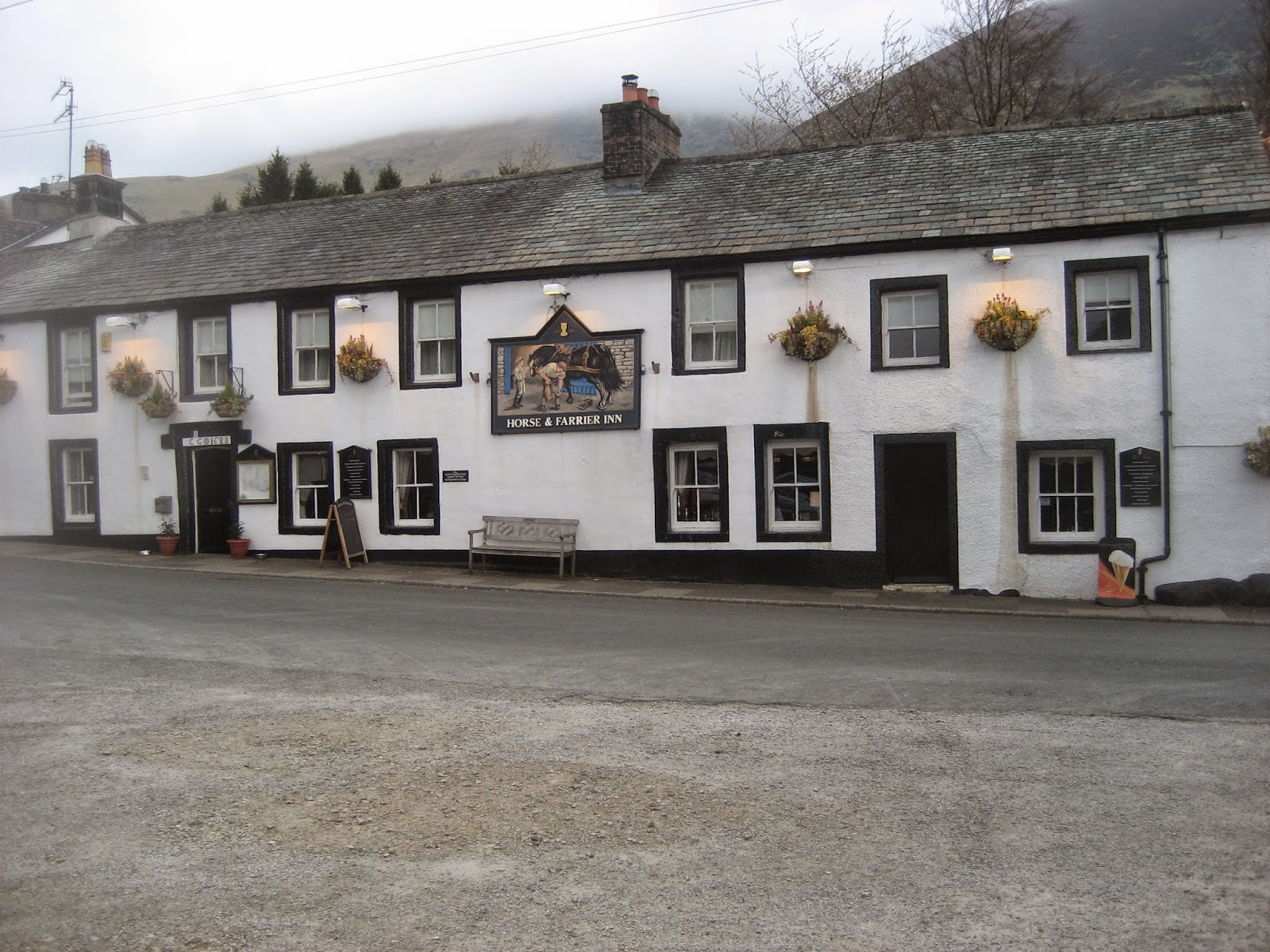
This is a relatively short walk, 6.1 miles but it is quite a tough one. We called in at the Horse and Farrier in Threlkeld for refreshment. They sell mainly Jennings Beers and their coffee was excellent.
                                           The juniors take another break
                             Gorse in bloom, it usually is
                             The Horse and Farrier, Threlkeld. Good beer, good food

THE MATRIX MMXV K
                                                                 steps                                  miles
Hi gear                                                        17127                            7.75
LIDL3D                                                      21629                            8.6
Dave's LIDL3D                                            16970                            6.58
Dave's LIDLUSB                                          16857                           6.91
OUTDOOR GPS                                                                               6.1


I have added some photographs taken by Harry, they are good as usual.
                                                     Starting out
                                                  On the way to Ullock Pike
                                               In the mist on Ullock Pike
                                                      Lunch at the summit
                                                   The summit trig point
                                                       The steep slope down
                                                     Looking back at Skiddaw

Saturday, 18 April 2015

Hedgehope again.... with a slightly different route.
  A landmark. Yesterday I passed 50000 hits.  not much compared to some blogs but it pleases me. For some reason the majority of readers on the last two days have been Russian or Ukrainian. It has been suggested that they are using the maps to study our little island, well their tanks would get bogged down today.
Five gadgies today, Harry, Dave, Brian, Ray and me, squeezed into Brian's car. We headed for Ingram, intending to breakfast in the Muddy Boots cafe but it was closed, a sign on the door said it was hoped it would open in early summer. On to Hartside where we parked just off the road. As a reminder to get here go north from Newcastle on the A1, turn off on the A697 and shortly after Powburn turn left at the sign post for Ingram. Follow the road for several miles to Hartside, where a polite notice requests you go no further. Take map OSOL 16 The Cheviot Hills. The car park is at NT977171, slightly different from the spot in "Walk the High Cantle" blogged on February 20th.
                  The car park, popular today and free. Hartside farm in the background.

The walk:
 We set off, with a very light breeze and high light clouds, almost perfect for walking. The road from the car heads west towards Linhope, a hamlet of some half a dozen houses tucked into the Linhope Burn valley. It is a pretty place, one house has 1879 on the gable, one house has a display of aubretia, tumbling down the wall.
                                                   Linhope
                                                 Aubretia at Linhope
The road curves round the houses, becomes a farm track and turns north west alongside a wood. If you want, take a detour to Linhope Spout, waterfall and pool. Or continue as we did and take the shepherds quadbike track on the left (Look for yellow markers, close the gates) that meanders across the moorland in a westerly direction past Rig Cairn before arriving at High Cantle.
                            Ray, Harry and Brian take in the views at High Cantle. Note the shorts, my hero!
 The ground was not quite as soggy today, there has not been much rain recently. At High Cantle we paused, enjoyed the views and continued across increasingly boggy ground in a north west direction along Sheilcleugh Edge  until we reached Coldlaw Cairn where we stopped for Herbie, just under five miles into the walk.
                Coldlaw Cairn, we ate on the other side out of the breeze which was increasing.
           As usual we shared our offerings: Mrs A's chocolate coated flapjacks, other flapjacks and Czech Chocolate.( I have brought back a good supply) The view over the hills was spoiled by the acres of coniferous plantations on the way up to Windy Gyle. They just don't look natural.
 As Brian relaxes, Dave and Ray get out their lunches.
                                     A feast of human forms for Kathy from Goole this week.
Lunch over, and temperature falling we followed the fence line due north before turning north east  over Comb Fell and then in an attempted straight line to the top of Hedgehope. Attempted because of the peat hags that had to be negotiated. At one point an attempt to aid walkers has been made by laying a geo-textile mat across the ground. A mesh of thick green plastic, it is hoped that when the grasses have grown through it will provide a bog free footpath. A polite notice asked walkers to keep off until the mat had been grassed through. At least two of the team are illiterate.


                                                 Pretty clear


                                            Approaching Hedgehope. I like this hill, it's the first I ever walked up
                                             in Northumberland, early in 1965. From the other side it looks like
                                            a child's drawing of a hill, neatly conical.

             Ray, Dave and Brian looking smug as I struggle to the top. Plus a trig point.
After a pause on the top, again to enjoy the views of the Cheviot and out to sea, there was some discussion on the way back. Some wanted to visit the Social Worker known as Great Standrop, others preferred the more direct and better path in a south east then southerly direction which eventually joins the farm track by the Linhope Burn. Others won. Once on the track we turned left and walked back through Linhope to the car.

                        Quadbike bridge, great invention.
                                                  Great Standrop known as the Social Worker
                                                 Going South from Hedgehope
                                           Distant Simonside. Linhope centre right.
We called in at the Anglers Arms on the way home. The pub was offering Marstons IPA, Speckled Hen and Timothy Taylors Landlord, what a choice. The bar maid expressed great surprise when informed that amongst us gadgies the birthday boy buys the drinks. In this case the task fell to me and Harry who share a birthday.
Another good walk out.

The Matrix MMXVJ
                                                                                      steps                          miles
LIDL3D                                                                      27786                            11.93
Higear                                                                         26090                             11.84
Dave's 3D                                                                   25758                             10.56
Dave's USB                                                                25129                             10.31
OUTDOORS GPS                                                                                             11
Brian's GPS                                                                                                        11.1
Ray's GPS                                                                                                           11

Pretty consistent