Wark, Redesmouth and Birtley (Northumberland)
April 16th.
Four of us: Margaret, Brian, John H. and I are setting out on a slight variation of a walk we have done several times from Wark, a village on the North Tyne in Northumberland. Easy to find, head north on the North Tyne and there it is.
The walk is on two maps, starting and finishing on OS OL 43 Hadrian's Wall with a section on OS OL 42 Kielder Water and Forest.
As you reach the village there is a pub and hotel on the left called Battlesteads. Directly opposite is a small off road parking area, free.
Parking and pub, hopefully the garden will be open at the end of the walk. Covid rules are relaxed a little.Booted up on a warm sunny day with hardly a breeze, just as the local weatherman had said we set off towards the village centre, turned right passing the Grey Bull Inn and the Black Bull Inn as we walked towards the narrow bridge which crosses the North Tyne.
Bridge and North Tyne at Wark.
Once over the bridge and untroubled water we turned left and followed the road for a short distance along the river until we joined the footpath. The trail here is sponsored by "Daft as a Brush", a cancer patient charity and it is well marked with the charity logo.
At Gold Island we saw two ladies and a little girl examining a very bright yellow flower. They asked us if we knew what it was as nobody had seen one like it before.
The magic of a flower spotters App on Brian's phone established it as an "American Skunk Cabbage".
American skunk cabbage. So called for its smell!. Native to the Pacific coast of America it grows in swampy water from Alaska to California. Brought to England in 1901 it managed to escape and is found mainly in the south. Maybe it got here with a bird in the time honoured fashion.
We continued walking along the river bank, watching Mandarin Ducks, Mallards and one or two thers whose names I have forgotten, until the track turns away from the river and crosses fields to Low Carry House.
This little lamb had lost its way. It was trying to get back to mum on the other side of the gate. She didn't seem that bothered. Unfortunately I was wearing my sunglasses and couldn't see the camera screen properly so only got its back end. We walked up the road from Low Carry to the signpost for High Carry House and followed the footpath across the field to the farm.
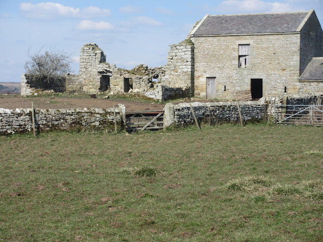
High Carry Farm buildings. The ruin on the left was once a peel tower. (Mini castle)
From High Carry we continued over fields, downhill, until we reached a track on the dismantled railway. A sharp right followed by an equally sharp left took us under the old railway and back down towards the North Tyne.
You've been framed.
Beyond the bridge we crossed a couple of fields before entering Countesspark Wood.
Ticks carried by deer are on the increase in the UK. Shorts are discouraged in areas where they are found.
The footpath through the wood brought us to the Herbie Spot we had headed for.
I think this is the most beautiful Herbie Spot in Northumberland if not England or even the whole of the UK. The log cabin is, presumably, the headquarters of a fishing club.The device on the left is for rods. Unfortunately the windows are all shuttered so we could not see inside. With the river and forest in the background it could be in Canada. We shared apple pies, Snickers, Mushroom tarts and chocolate cup cakes or buns as we used to call them.
Lunch over we walked on, climbed a short bank to the dismantled railway line and arrived in Redesmouth.
Redesmouth station that was.
When we reached the village we turned right on the road and walked uphill a short way to the sign post for Buteland. The footpath is not too clear but it exists, the way is uphill.
Buteland farm is interesting, it has a couple of holiday caravans and some works of art;
Whoops. Put my shades back on for what is a dog made from horseshoes. Not too far away is a horse made in the same way.
From Buteland we headed due south on a minor road, through Buteland Wood on a hard to follow path and across fields until we reached the Holywell.
Holywell. A bit short of water as is most of the country at the moment.
Above the well we climbed a fence, crossed the road and took a footpath over the fields, climbing several ladder stiles which are a bit easier than the simpler ones, until we reached the road again and walked into Birtley.
Birtley is a pretty linear village without a pub. Outside the village is a Norman Church, St Gile's.
 |
St Giles Church, Birtley. Norman origins.
|
Opposite the church is a footpath, initially fenced and narrow but it opens into fields and eventually joins the road downhill and back to the bridge across the river at Wark.
The Battlesteads pub had opened at 5pm, service in the big garden behind the hotel only. Choice of ale was limited, probably as the place has only just reopened. I was driving anyway but had a very refreshing pint of soda and lime, well earned after a long walk on a warm day.
Contains OS data. Copyright. Crown Copyright and database right 2021.
The walk is about 11.5 miles with some climbing. But worth it especially for the river section.


No comments:
Post a Comment