Walk 20 (Northumberland ) March 6th
(Or a tale of two quarries)
MUD WARNING
(Or a tale of two quarries)
MUD WARNING
The walkers of Haltwhistle have devised some 28 walks in the area. There used to be a leaflet containing them but it's hard to find. Fortunately they are available to download at haltwhistle.org/index.php/miscellaneouspages/28walks
Making a change from old railway lines five of us (Ben, Dave, Harry, John H. and me) are following walk number 20 today. The weather is supposedly fine and there has been no rain for a week so the tracks across country should be dry-ish. The walk is on or near Hadrian's Wall and the OS map to use is OL Exolorer 43, Hadrian's Wall. or download the map and notes . Our walk starts at the car park at Cawfield, a name possibly derived from the number of crows and jackdaws in the area.
Easy to find, head west on the A69, take the Military Road (B6318) and look for sign posts.
Like several of our Northumbrian walks this one is a trek from farm to farm, sometimes over fields, sometimes on tracks and roads.
 Car park of the day at Cawfields. (Once a quarry) £5 to park for a day but split five ways it's a bargain. A high tech payment system requiring the input of registration numbers makes it even more exciting. And there are toilets.
 Shadow over Cawfields Quarry which was in use from Roman times to 1945
Booted and suited for a sunny but cool day we set off on the north side of the pond and having had a quick look at the milecastle (Number 42, they are numbered east to west) on the wall we headed on the north side of Hadrian's boundary line on a track which became a muddy footpath across fields, passing Cawfields farm, crossing a rather dodgy footbridge until we came to Low Close a Burns where we headed north for a short distance in the mud to High Close a Burns.
From this farm we walked the muddy fields and crossed a muddy burn to Cleughfoot farm where we saw the first lambs of the year.
 The Whinsill . Much of the wall is on the edge of this line.
 Looking fairly new!

Nice jacket young lamb
At Cleughfoot we walked, thankfully as it was dryish, on the farm track before joining a very minor road heading northish. At one point the road crosses a Roman Aquaduct, not that there is much to see.
At the point marked 218 (metres) on the map there is a cattle grid (CG) and a finger post heading westish across the muddy fields of Bundle Hill until the path joins the farm road a little east of Low Tipalt.
From this farm we stuck to the road which turned south west then almost south until we reached Walltown.
Walltown is another disused quarry which, like Cawfields, has been turned into a visitor centre with easy access to a section of wall.
 Pretend Roman oven at Walltown.
There are a number of picnic seats in the area, we chose the ones overlooking the pond and held a Herbie.
 There was a pair of swans on the water and several mallards. Initially interested a s we ate they soon realised there was nothing for them but we shared Titan, Jaffa Cakes, flapjacks and Ben's ginger biscuits.
Lunch over we followed the footpath round the pond and started the first climb on the Hadrian Wall Path, passing the remains of turret 45B (Two turrets between each mile castle, numbered and lettered after the mile castle).
 Looking back down at our picnic spot at Walltown centre.
 Remains of the wall at Walltown
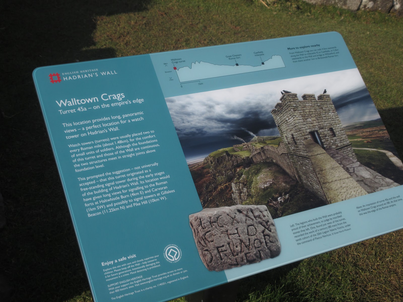
 Remains of turret 45A
 And how it probably looked.
From here we stayed on the wall path which is right next to the structure itself. Because the wall follows closely the topography and so does the footpath, there are a number of steep up and down sections, bit wearing on the knees. They have been well "stepped" with stones making progress easier as it would have been very slippy otherwise. We passed the sites of several turrets and a couple of mile castles before we reached Great Chesters, site of the Roman fort Aesica. Unlike Housesteads or Vindolanda there is not a lot to see but the remains of the strong room where the legions cash was kept are visible.
 Remains of the strong room at Aesica
 and an altar, possibly at Aesica
From Aesica the footpath heads gently downhill but across muddy fields to Cawfields.
We called in at the Wylam Boathouse Tavern on the way home which had its usual selection of ales and some lager too.
 Wylam Boathouse

Like several of our Northumbrian walks this one is a trek from farm to farm, sometimes over fields, sometimes on tracks and roads.


Booted and suited for a sunny but cool day we set off on the north side of the pond and having had a quick look at the milecastle (Number 42, they are numbered east to west) on the wall we headed on the north side of Hadrian's boundary line on a track which became a muddy footpath across fields, passing Cawfields farm, crossing a rather dodgy footbridge until we came to Low Close a Burns where we headed north for a short distance in the mud to High Close a Burns.
From this farm we walked the muddy fields and crossed a muddy burn to Cleughfoot farm where we saw the first lambs of the year.


At Cleughfoot we walked, thankfully as it was dryish, on the farm track before joining a very minor road heading northish. At one point the road crosses a Roman Aquaduct, not that there is much to see.
At the point marked 218 (metres) on the map there is a cattle grid (CG) and a finger post heading westish across the muddy fields of Bundle Hill until the path joins the farm road a little east of Low Tipalt.
From this farm we stuck to the road which turned south west then almost south until we reached Walltown.
Walltown is another disused quarry which, like Cawfields, has been turned into a visitor centre with easy access to a section of wall.

There are a number of picnic seats in the area, we chose the ones overlooking the pond and held a Herbie.

Lunch over we followed the footpath round the pond and started the first climb on the Hadrian Wall Path, passing the remains of turret 45B (Two turrets between each mile castle, numbered and lettered after the mile castle).


From here we stayed on the wall path which is right next to the structure itself. Because the wall follows closely the topography and so does the footpath, there are a number of steep up and down sections, bit wearing on the knees. They have been well "stepped" with stones making progress easier as it would have been very slippy otherwise. We passed the sites of several turrets and a couple of mile castles before we reached Great Chesters, site of the Roman fort Aesica. Unlike Housesteads or Vindolanda there is not a lot to see but the remains of the strong room where the legions cash was kept are visible.


From Aesica the footpath heads gently downhill but across muddy fields to Cawfields.
We called in at the Wylam Boathouse Tavern on the way home which had its usual selection of ales and some lager too.


Contains OS data, copyright. Crown copyright and database right 2020
And a matrix
steps miles
NAK 19526 8.62 a bit short
Dave's NAK 1 22008 10.42
"""""""""""""2 21992 10.41
""""""""""""SM 21986 10.41
OUTDOOR GPS 9.5
And a few more pictures


And a matrix
steps miles
NAK 19526 8.62 a bit short
Dave's NAK 1 22008 10.42
"""""""""""""2 21992 10.41
""""""""""""SM 21986 10.41
OUTDOOR GPS 9.5
And a few more pictures


No comments:
Post a Comment