A walk in the park (Northumberland) January 31
{Or the last walk in Europe}
The United Kingdom of Great Britain and Northern Ireland leaves the European Union at 2300 GMT on January 31st.
This has nothing to do with today's walk. The weatherman says rain today so we are having a gentle stroll through Hulne Park, the back garden of the Duke of Northumberland. It is open to the public most days but it is always worth checking that it has not been closed for some reason. Easy to find on the magic web.
To get to the park take the A1 north, go through Alnwick town, past the main entrance to the castle on the right and after a few hundred yards turn left to the entrance gate. There is limited parking on one side of the road. Do not park on the other, you could be thrown into a deep and dark dungeon.
It is possible to walk round the park without a map but should you want one it's OS Explorer 332 Alnwick and Amble. It is also possible to download a leaflet which includes a map showing the different paths in the park.
For breakfast we stopped at Barter Books, a second hand book emporium in the old Alnwick railway sation on the left as you approach the town. One of the best second hand book shops in the country, nice café too.
 Barter Books entrance; lots of second hand books
 The Northumberland Lion in Alnwick, across the road from Barter Books
Oh! S***!!! On Thursday morning I checked on the Northumberland estate to make sure the park was open to the public. It was. But I double checked by calling the estate office and the man who answered looked at the diary, got back to me and told me it was fine to visit.
Then, as usual, on a Thursday evening I wrote the introduction, found the right map, gave a little thought to directions and prepared for the walk.
When we arrived at the park gates a large notice informed us it was closed! A man in the gatehouse came out and apologised, the gamekeepers had not informed the castle that there would be a shoot today. He had had to turn a number of people away.
So we went to Longhoughton near the coast. (Same map)
 Hulne Park entrance, the notice on the left says closed
 Changing boots are Longhouton NAAFI. Well it used to be the NAAFI for the local RAF station.
Longhoughton is a long Northumbrian village close to an RAF base. Some of the more modern streets have been given the names of RAF heroes, like Douglas Bader.
Behind the hall which used to be the local shop and NAAFI (Navy, Army and Air Force Institute) is a small car park. Once booted and coated we left the park, turned left down the village high street and almost immediately turned left again down the road past Low Stead Farm to the England Coast Path.
When we reached the path we headed north on the footpath which was pleasantly dry, much better than the paths we have trod for the last few weeks.
The names of areas on the coast are always interesting.
We hit the path at Howdiemont Sands, walked past Sugar Sands, a secluded little beach and Iron Scars, famous for its freshwater spring and layers of sedimentary rock. (Bring out the jacket!)
 The trickle left of centre is the famous fresh water spring and the geological formations behind get geologists excited.
 Footbridge over the Howick Burn
 Howick Burn
Beyond the Howick Burn we past Howick Haven, Rumbling Kern,, Swine Den, Cullernose Point, Black Hole and Hole o' the Dike before reaching Craster where we called a Herbie, making use of seats overlooking the harbour.
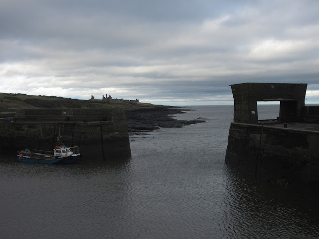
 Craster Harbour and Dunstanburgh Castle in the background. Today's feast included several varieties of biscuit, including Ben's gingers, Scones from Mrs A and my newly discovered Bliss biscuits which require more calories to digest than they contain.
Lunch over we continued north on the Coast Path, Liverpool Hole, Oxberrylaw Holes, Nova Scotia and Cushat Stiel before we approached the castle.
 Dunstanburgh Castle.
We took the footpath west of the castle, (is it possible to go east of it?) and walked past Rumble Churn and Greymare Rocks until we reached the road that leads to Dunstan Heads on the edge of the golf course. The road follows Embleton Burn before turning at Shirewater Low Mill and soon we were at the bus stop in Embleton and fortunately everybody had their bus pass!
The bus (X18) took about 15 minutes to get back to Longhoughton. There are not many buses on this route so check times carefully if you decide to follow our path. The other bus to run the route is Travelsure 418.
Changed we headed for the Cook and Barker at Newton on the Moor, just boff the A1 south of Alnwick. The pub had several ales on offer, the one I had, a blonde beer, was very pleasant so I had another.

 Cook and Barker, outside and inside
 Contains OS data, copyright. Crown copyright and data base right 2020
And a mileage matrix this week
steps miles
NAK 18782 7.7
Dave's NAK 1 16167 7.65
""""""""""""""2 16196 7.66
""""""SM 16204 7.67
OUTDOOR GPS 7.76
BRIAN'S GPS 7.7
And a few pictures


{Or the last walk in Europe}
The United Kingdom of Great Britain and Northern Ireland leaves the European Union at 2300 GMT on January 31st.
This has nothing to do with today's walk. The weatherman says rain today so we are having a gentle stroll through Hulne Park, the back garden of the Duke of Northumberland. It is open to the public most days but it is always worth checking that it has not been closed for some reason. Easy to find on the magic web.
To get to the park take the A1 north, go through Alnwick town, past the main entrance to the castle on the right and after a few hundred yards turn left to the entrance gate. There is limited parking on one side of the road. Do not park on the other, you could be thrown into a deep and dark dungeon.
It is possible to walk round the park without a map but should you want one it's OS Explorer 332 Alnwick and Amble. It is also possible to download a leaflet which includes a map showing the different paths in the park.
For breakfast we stopped at Barter Books, a second hand book emporium in the old Alnwick railway sation on the left as you approach the town. One of the best second hand book shops in the country, nice café too.


Oh! S***!!! On Thursday morning I checked on the Northumberland estate to make sure the park was open to the public. It was. But I double checked by calling the estate office and the man who answered looked at the diary, got back to me and told me it was fine to visit.
Then, as usual, on a Thursday evening I wrote the introduction, found the right map, gave a little thought to directions and prepared for the walk.
When we arrived at the park gates a large notice informed us it was closed! A man in the gatehouse came out and apologised, the gamekeepers had not informed the castle that there would be a shoot today. He had had to turn a number of people away.
So we went to Longhoughton near the coast. (Same map)


Longhoughton is a long Northumbrian village close to an RAF base. Some of the more modern streets have been given the names of RAF heroes, like Douglas Bader.
Behind the hall which used to be the local shop and NAAFI (Navy, Army and Air Force Institute) is a small car park. Once booted and coated we left the park, turned left down the village high street and almost immediately turned left again down the road past Low Stead Farm to the England Coast Path.
When we reached the path we headed north on the footpath which was pleasantly dry, much better than the paths we have trod for the last few weeks.
The names of areas on the coast are always interesting.
We hit the path at Howdiemont Sands, walked past Sugar Sands, a secluded little beach and Iron Scars, famous for its freshwater spring and layers of sedimentary rock. (Bring out the jacket!)


Beyond the Howick Burn we past Howick Haven, Rumbling Kern,, Swine Den, Cullernose Point, Black Hole and Hole o' the Dike before reaching Craster where we called a Herbie, making use of seats overlooking the harbour.


Lunch over we continued north on the Coast Path, Liverpool Hole, Oxberrylaw Holes, Nova Scotia and Cushat Stiel before we approached the castle.

We took the footpath west of the castle, (is it possible to go east of it?) and walked past Rumble Churn and Greymare Rocks until we reached the road that leads to Dunstan Heads on the edge of the golf course. The road follows Embleton Burn before turning at Shirewater Low Mill and soon we were at the bus stop in Embleton and fortunately everybody had their bus pass!
The bus (X18) took about 15 minutes to get back to Longhoughton. There are not many buses on this route so check times carefully if you decide to follow our path. The other bus to run the route is Travelsure 418.
Changed we headed for the Cook and Barker at Newton on the Moor, just boff the A1 south of Alnwick. The pub had several ales on offer, the one I had, a blonde beer, was very pleasant so I had another.


And a mileage matrix this week
steps miles
NAK 18782 7.7
Dave's NAK 1 16167 7.65
""""""""""""""2 16196 7.66
""""""SM 16204 7.67
OUTDOOR GPS 7.76
BRIAN'S GPS 7.7
And a few pictures


No comments:
Post a Comment