A country stroll from Belsay (Northumberland)
January 25th
It has been cold this week in the northeast of the UK, not as cold I suspect as Indian Head in Saskatchewan but cold enough for heavy frost. But today the temperature is going to rocket to 11C. With the possibility of rain in the west of the county we have opted for another local walk centred on Belsay, a village some few miles northwest of Newcastle with a hall, a castle and some fine gardens.
It also has a smart coffee shop, the Blacksmiths, where we can breakfast and leave cars.
To get to this delightful spot from Newcastle drive through Ponteland and keep going until you reach Belsay. The café is on the left just as you enter the village.
The map for this walk is OS Explorer 316, Newcastle upon Tyne and it would be useful.
Warning: This walk can be very muddy.
And it was. Not a lot of rain but several heavy frosts which had melted on a much warmer day made the ground in the fields muddy, or claggy as we say in the North East of England.
Eight of us out today, making up what Ben has called an atrophy of gadgies, (or the atrophic eight today) collective noun of the week.
We are John x 3, Ben, Brian, Harry, Dave and me.
There is a small parking area opposite the café,
room for several cars.
Today's car park in Belsay, across from.....
the Blacksmiths coffee shop. Busy place, most of the clientele were like us, mature, somewhat sophisticated and probably cultured.
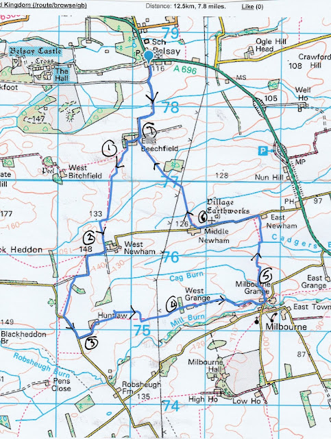
Leaving the café we headed south on a farm track,
passing the Belsay Woodland Burials field, turning through couple of neat right-angled
bends until we reached the first farm on our country walk, East Beechfield. We
walked through the large farm yard, turned left and almost immediately took the
footpath across the field. No signpost or marker but it is marked on the map.
The field has a collection of unusual looking mounds, not marked on the map,
but as Dave explained, possibly the remains of a medieval village.
Way to go
East Beechfield
Medieval Remains?
We crossed the fields, climbed over a couple of
dodgy stiles, got the first layer of mud on boots, until we reached the farm at
West Newham. From here we took the road, turned through two neat right-angles
until we spotted a sign post on the left pointing over more muddy fields. We
followed it until it joined the road, walked the road for a short distance
before turning left to the next farm at Huntlaw, home of three fine looking
alpacas, several geese and some sheep.
You can call me Betty, and I can call you Al
The geese that saved Huntlaw
Beyond the farm, some way down the track we took the
footpath across more fields to the farm at West Grange. And from there we
followed a track to the road at Milbourne Grange.
Milbourne Methodist chapel built 1903
Turning left on the road, just past the brick built
Methodist Chapel, we spotted a signpost on the left and entered a wood. As it
was out of the breeze we called a Herbie and sat or stood among the trees for
lunch.
Merry men of Milbourne. We shared Titans, cookies, flapjacks, Ben's ginger biscuits and scones from Mrs A.
Lunch over we continued north on our muddy way, scrambling
round a small pond on the nicely named Cadgers Burn and walking up a slight
gradient to East Newham.
Pond on Cadgers Burn
Remains of an old windmill at East Newham.
Turning left we walked along the road to Middle
Newham, spotting on the right a gate with marker. In the field were more
unusual mounds, marked on the map as Village Earthworks in Gothic Script so
they must be old.
Not much to see but once it was a village
Muddy footpaths across across the fields brought us
back to East Beechfield and the track to the car park.
Having scraped some of the Northumberland mud of
boots we headed for the Seven Stars pub in Ponteland. Several hand pulled beers
on offer, Speckled Hen, Rivet Catcher and the famous Timothy Taylor’s Landlord.
The coffee was good too for the driver.
Contains OS data, copyright. Crown copy right and databaseright 2019
MATRIX MMXIX 1d
Steps miles
NAK
20810
7.55
Dave’s NAK 1 16452 7.53
“””” NAK 2
16446
7.52
“””””””USB
16708 7.64
“”” SM
16169
7.55
Etre 2hr 46 min walk 54 min talk
7.97
Brian
7.5
John C
7.8
And a gallery


No comments:
Post a Comment