In the heat of the day.. (Northumberland ) July 27
Back home after the Arran adventure, the team is reduced to three, holidays and family commitments.
Britain has been enduring a heat wave for a couple of weeks, nanny has reminded us gadgies to take care as we are vulnerable, drink plenty, use sun cream, wear a hat, take a siesta and so on. Furthermore the jovial jock on local TV has promised this will be a hot day, ending about 3pm with thunderstorms. So we three, Brian, Harry and I are having a gentle walk based on the small Northumberland town of Rothbury. (A1 north, A697 at Morpeth, B6341 at Weldon Bridge.) Cross the river in the town and use the free car park.
We went to Tomlinsons Café and Bunkhouse on Bridge Street for breakfast and having booted up in the car park we started our walk from the café.
Nearly all the walk is covered by OS Explorer 332 Alnwick and Amble, the bit not on this map is along the river near the end, you can't get lost.
Having breakfasted we checked we had obeyed nanny and slapped on the sun cream , made sure we had water or tea for rehydration sessions and were wearing hats or caps to protect the top of our heads.


The walk:
We went back up Bridge Street to the main road through Rothbury, turned right, crossed the road and took the first street on the left. We past the row of flats built by Lord Armstrong for his estate workers, past some relatively new bungalows and found the sign post on the left that took us across a couple of fields to Hillside Road.
 Lord Armstrong made his fortune making guns, battleships and a host of other things, like the Swing Bridge across the Tyne in Newcastle. He built his country home, Cragside, outside Rothbury and lit it with the first hydro-electric system in Britain. Today it is owned by the National Trust.
We followed Hillside Road until it became a track and then found another sign post that crossed a couple of fields until it reached woodland. At this point we turned left and followed the track through the woods, stopping at one view point to look down on the town.
 Rothbury. At this point it started to rain so we followed nanny's instructions and put our waterproof tops on. Then it stopped so after a few minutes we took them off again.
At the end of the track through the wood, just beyond a gate, we followed a footpath on the right that took us across rough moorland, and almost due north, to another plantation and another fairly good track which eventually emerged onto heather covered moorland. The heather is coming into bloom, looks lovely but there was no wild mountain Thyme. Heading north west we stuck to the track past Crocky's Heugh (marked on Ordnance Survey map) and on to the edge of yet another plantation. Not far into it we turned left at the entrance to Blue Mill:
 The entrance to Blue Mill.
The track climbs, but not too steeply as it was a very hot day and we are vulnerable. If you follow this route watch out for a marker post on the right after about half a mile and follow the footpath across a short stretch of moorland before hitting yet another track, and turn right.
Not far down this track we called a Herbie and sat on an old stone gate post that had been pushed over, making a reasonably comfy seat.

Herbie Spot. Nice dry stone wall, attractive but thirsty tree, no rain for a couple of weeks.
Gadgie moment: For my contribution to the Herbie I had planned to bring chocolate. As it was a hot day I put one of those plastic bottle full of frozen liquid in my food box to stop the chocolate melting. Sadly I had left the chocolate at home in the fridge. Mrs A had sent some lemon drizzle cake.
Herbie over we continued on the track for a short distance before spotting the entrance on the right to the fascinatingly named Physic Lane.
 The entrance to Physic Lane, which overlooks the village of Thropton


Bridge over the Wreigh burn


Cob, pen and cygnets on the river Coquet


Back home after the Arran adventure, the team is reduced to three, holidays and family commitments.
Britain has been enduring a heat wave for a couple of weeks, nanny has reminded us gadgies to take care as we are vulnerable, drink plenty, use sun cream, wear a hat, take a siesta and so on. Furthermore the jovial jock on local TV has promised this will be a hot day, ending about 3pm with thunderstorms. So we three, Brian, Harry and I are having a gentle walk based on the small Northumberland town of Rothbury. (A1 north, A697 at Morpeth, B6341 at Weldon Bridge.) Cross the river in the town and use the free car park.
We went to Tomlinsons Café and Bunkhouse on Bridge Street for breakfast and having booted up in the car park we started our walk from the café.
Nearly all the walk is covered by OS Explorer 332 Alnwick and Amble, the bit not on this map is along the river near the end, you can't get lost.
Having breakfasted we checked we had obeyed nanny and slapped on the sun cream , made sure we had water or tea for rehydration sessions and were wearing hats or caps to protect the top of our heads.

Today's car park in Rothbury, spacious and free

Tomlinsons café and bunkhouse, Rothbury
We went back up Bridge Street to the main road through Rothbury, turned right, crossed the road and took the first street on the left. We past the row of flats built by Lord Armstrong for his estate workers, past some relatively new bungalows and found the sign post on the left that took us across a couple of fields to Hillside Road.

We followed Hillside Road until it became a track and then found another sign post that crossed a couple of fields until it reached woodland. At this point we turned left and followed the track through the woods, stopping at one view point to look down on the town.

At the end of the track through the wood, just beyond a gate, we followed a footpath on the right that took us across rough moorland, and almost due north, to another plantation and another fairly good track which eventually emerged onto heather covered moorland. The heather is coming into bloom, looks lovely but there was no wild mountain Thyme. Heading north west we stuck to the track past Crocky's Heugh (marked on Ordnance Survey map) and on to the edge of yet another plantation. Not far into it we turned left at the entrance to Blue Mill:

The track climbs, but not too steeply as it was a very hot day and we are vulnerable. If you follow this route watch out for a marker post on the right after about half a mile and follow the footpath across a short stretch of moorland before hitting yet another track, and turn right.
Not far down this track we called a Herbie and sat on an old stone gate post that had been pushed over, making a reasonably comfy seat.

Gadgie moment: For my contribution to the Herbie I had planned to bring chocolate. As it was a hot day I put one of those plastic bottle full of frozen liquid in my food box to stop the chocolate melting. Sadly I had left the chocolate at home in the fridge. Mrs A had sent some lemon drizzle cake.
Herbie over we continued on the track for a short distance before spotting the entrance on the right to the fascinatingly named Physic Lane.


Thropton.
Physic Lane eventually transforms into a tarmac road, passes several houses and joins the B6341 from Rothbury near the Cross Keys pub (opens at 3pm on a Friday)
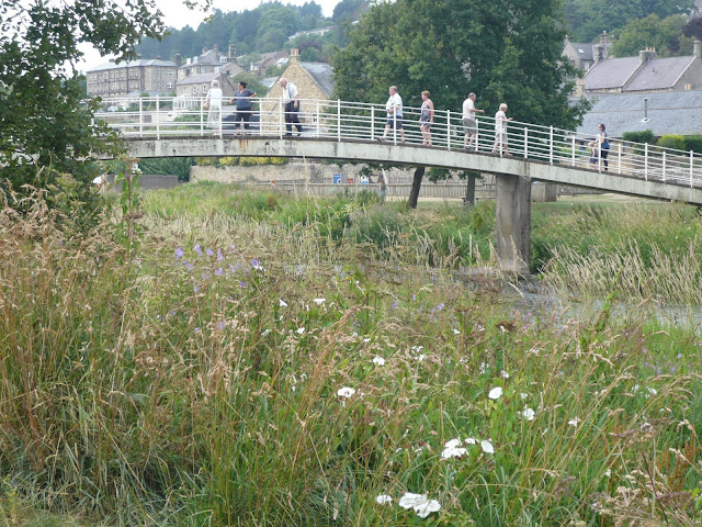
We crossed the Wreigh Burn by the footbridge which runs next to the road bridge, crossed the road and followed the footpath alongside the burn until we reached another footbridge across the River Coquet.


Footbridge over the Coquet. The river is very low, there has been no rain for several weeks.
We discussed, briefly, which route to take back to Rothbury, via the village of Tosson or the shorter path alongside the river. We chose the latter, mainly because it was a hot day and we had been promised thunder and heavy rain about 3pm.
The footpath alongside the river is very pretty, very flat and could be a useful geography lesson. In places, on bends, the bank has been washed away, the footpath has had to be moved!. Future Ox-Bow lakes.
This section of the walk is not on OS 332 but it is easy to follow as it follows the river to a footbridge taking us to the north side of the Coquet. We followed the footpath across a field and took the well built walkers/dogsters track back to the car park.


One more footbridge nearing Rothbury
Once changed we headed for The Anglers Arms at Weldon Bridge to do as nanny said and rehydrate. There were three hand pulled beers on offer, a Fizzy Blonde, Black Sheep and Another. The Black Sheep was very re hydrating.
Unfortunately I had forgotten my pedometer and Dave, the pedometer man was away so no Matrix this week.
OUTDOOR GPS measured the walk at 8.5 miles and Brian agreed.
The thermometer in the car claimed 26C, with high humidity.
When |I got home the storm started, heavy rain, thunder, lightning. Shame as the cloud blocked out the Blood Moon.
The thermometer in the car claimed 26C, with high humidity.
When |I got home the storm started, heavy rain, thunder, lightning. Shame as the cloud blocked out the Blood Moon.

Contains OS data, copyright. Crown copyright and data base right 2018.


No comments:
Post a Comment