Castles, chapel and cathedral. Life could be good as a bishop.................March 22nd
Yet again a trip to the Lake District was postponed because of the weather. Snow this time, which could have made the journey difficult. Some gadgies, with gadgettes, were away so the three of us who were left to keep the flag flying opted for a real gadgie walk, by bus.
Vm. mm, and bm caught the 10.05 X21 from the famous Eldon Square bus station and stayed on it all the way to Bishop Auckland, with the intention of walking back to Durham and busing home.
This walk is along another County Durham railway line, the Brandon Bishop Auckland Railway Path. It is very easy to follow but should you require a map OS305 (Bishop Auckland) and OS308 (Durham) cover the whole of the walk.
 Continuing a series on car parks and bus stations, this is Bishop Auckland. The tall building, quite out of character with the town is called Vinovium House after the nearby Roman fort.
,It was a very cold day with the wind, having arrived from Siberia, adding several degrees to the actual temperature but in the negative direction so we decided to forego the usual bacon butty and get on with the job.
But first a bit about Bishop Auckland.
A pretty Durham town on the old Roman road Dere street. The Romans had a look-out post where the town now stands and a cavalry camp at Vinovia (Now Binchester) in the Wear Valley, foundations still to be seen but they look like most other Roman fort foundations. The camp was on the supply route to Hadrian's Wall. Long after the Romans went home the local Saxons built a church but the town really came to prominence in the 11th century when the Bishop of Durham thought it was a good place for a palace as the local forest provided some excellent hunting. Hence the word Bishop in the town's name. The town is situated at the confluence of the rivers Wear and Gaunless (Gaunless being Norse for Useless. cf that great Yorkshire word gormless meaning silly, accident prone or not very intelligent.) It has been suggested that Auckland compares to the Scots Allt Clud almost as in Clyde.
Like many Durham towns Bishop Auckland prospered in the days of coal and has suffered some decline with the loss of that industry.
To return to the Bishop; he built a palace here, now the castle, and a chapel. The castle was used in preference to the bishop's residence in Durham Castle, much more convenient for the cathedral though it was! Durham Castle was given by the church to the new University of Durham in the mid 19th century.
The walk, at last.
We left the bus station in the north west corner and headed down the A689 to Newton Cap viaduct. Once a railway bridge, when Beeching swung his axe it was converted to a road bridge, and a fine one too.

Newton Cap Viaduct, click to enlarge.

The River Wear from the viaduct. The Wearside Walk is another path to
be taken one day, at least as far as Durham.
Having crossed the viaduct we easily found the small blue sign that pointed us on our way down the old railway line to Durham. This first section of the walk is probably the most picturesque as it looks down on the river (and the local sewage works!) For about three miles we walked at a fair pace, to keep warm, chatting about the usual inconsequential things and, strangely, singing one or two Frank Sinatra standards. Amazing what cold weather can do to a body.
The path goes through the town of Willington, another old mining community hit hard by closures, passing allotment gardens, untended because of the weather. Normally they would have been a hive of activity. Just beyond Willington is a large old building. We couldn't decide what it produced, but it seemed busy.
 If you know what it produces, pass it on please.
Between Willington and Brancepeth the walk passes through open country but as it is well loined with trees it is a bit difficult to see and admire. Near Brancepeth we made a Herbie stop, utilising a bench that offered little view but some comfort. Pieless and chocolateless we made a hurried meal, glad to be on our way because of the cold.
 A winter's day, in a deep and dark March.
Not too far from Brancepeth the railway walk took us alongside a fairly new housing estate as we entered Brandon, another ex mining town.. The area that had been Brandon pit had been transformed into a smart sports ground and if you look at the map carefully you will see that the path took us round three sides of the cricket ground!
 Brandon cricket ground. It was very cold today,
the season starts in a couple of weeks.
Ah! The English summer game.
 The information board at Brandon Pit.
The area is called the Ponderosa but here was no
sign of Ben, his young bride or grown up sons Little Joe,
Adam or Big Hoss. Out rustling ?
Not far from Brandon, near Langley Hall Farm, the footpath leaves the railway track and goes down a steep path on the right, crosses the River Deerness by a footbridge and then climbs steeply to join the Deerness Valley Walk. There are even signs to tell you the path is steep! Soon we joined the Lanchester Valley Walk, but only for a short distance. Turning right at a rather elaborate signpost saying Durham1 mile we went through a farmyard at Baxter Wood, across a field and across the River Brownie.

Turn right for Durham.
Once over the river we turned right, following the sign for Neville's Cross Battle.
 Head for the battlefield...............
 .......................along the River Brownie.
We followed the path, turned right up the lane and emerged at the footbridge built to commemorate the famous battle.
 Somewhere near here, on October 17th 1346 the Scots lost away to the English
 How the teams lined up for the battle.
Once across the bridge we headed towards Durham, finding the footpath between the houses that took us down to the bus station.
 Another railway viaduct, in use too. It carries the main line between
London and Edinburgh
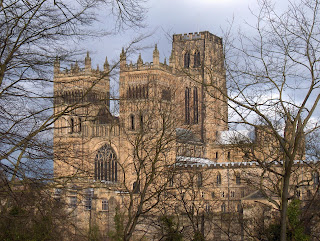 Couldn't resist it. Isn't it magnificent.
We caught the first bus heading to Newcastle and went to The Five Swans, a Wetherspoons hostelry close to the centre of the city and offering, among a few others, London Pride and Abbot. I suffered a couple of Abbot and caught the bus home..
Matrix MMCCVI
steps miles
ASDAPED 23566 11.07
Dave's ASDAped 23162 11.11
LIDLUSB 22976 11.24
OUTDOORGPS 11.62
Measured by Dave 11.4
Measured by me 11 .3
Pretty good eh!
 Bird of the blog: we saw kestrels, crows, families of finches and families of tits, nut the winner today is the jay
 Still having problems enlarging photographs
Yet again a trip to the Lake District was postponed because of the weather. Snow this time, which could have made the journey difficult. Some gadgies, with gadgettes, were away so the three of us who were left to keep the flag flying opted for a real gadgie walk, by bus.
Vm. mm, and bm caught the 10.05 X21 from the famous Eldon Square bus station and stayed on it all the way to Bishop Auckland, with the intention of walking back to Durham and busing home.
This walk is along another County Durham railway line, the Brandon Bishop Auckland Railway Path. It is very easy to follow but should you require a map OS305 (Bishop Auckland) and OS308 (Durham) cover the whole of the walk.

,It was a very cold day with the wind, having arrived from Siberia, adding several degrees to the actual temperature but in the negative direction so we decided to forego the usual bacon butty and get on with the job.
But first a bit about Bishop Auckland.
A pretty Durham town on the old Roman road Dere street. The Romans had a look-out post where the town now stands and a cavalry camp at Vinovia (Now Binchester) in the Wear Valley, foundations still to be seen but they look like most other Roman fort foundations. The camp was on the supply route to Hadrian's Wall. Long after the Romans went home the local Saxons built a church but the town really came to prominence in the 11th century when the Bishop of Durham thought it was a good place for a palace as the local forest provided some excellent hunting. Hence the word Bishop in the town's name. The town is situated at the confluence of the rivers Wear and Gaunless (Gaunless being Norse for Useless. cf that great Yorkshire word gormless meaning silly, accident prone or not very intelligent.) It has been suggested that Auckland compares to the Scots Allt Clud almost as in Clyde.
Like many Durham towns Bishop Auckland prospered in the days of coal and has suffered some decline with the loss of that industry.
To return to the Bishop; he built a palace here, now the castle, and a chapel. The castle was used in preference to the bishop's residence in Durham Castle, much more convenient for the cathedral though it was! Durham Castle was given by the church to the new University of Durham in the mid 19th century.
The walk, at last.
We left the bus station in the north west corner and headed down the A689 to Newton Cap viaduct. Once a railway bridge, when Beeching swung his axe it was converted to a road bridge, and a fine one too.
Newton Cap Viaduct, click to enlarge.

The River Wear from the viaduct. The Wearside Walk is another path to
be taken one day, at least as far as Durham.
Having crossed the viaduct we easily found the small blue sign that pointed us on our way down the old railway line to Durham. This first section of the walk is probably the most picturesque as it looks down on the river (and the local sewage works!) For about three miles we walked at a fair pace, to keep warm, chatting about the usual inconsequential things and, strangely, singing one or two Frank Sinatra standards. Amazing what cold weather can do to a body.
The path goes through the town of Willington, another old mining community hit hard by closures, passing allotment gardens, untended because of the weather. Normally they would have been a hive of activity. Just beyond Willington is a large old building. We couldn't decide what it produced, but it seemed busy.

Between Willington and Brancepeth the walk passes through open country but as it is well loined with trees it is a bit difficult to see and admire. Near Brancepeth we made a Herbie stop, utilising a bench that offered little view but some comfort. Pieless and chocolateless we made a hurried meal, glad to be on our way because of the cold.

Not too far from Brancepeth the railway walk took us alongside a fairly new housing estate as we entered Brandon, another ex mining town.. The area that had been Brandon pit had been transformed into a smart sports ground and if you look at the map carefully you will see that the path took us round three sides of the cricket ground!

the season starts in a couple of weeks.
Ah! The English summer game.

The area is called the Ponderosa but here was no
sign of Ben, his young bride or grown up sons Little Joe,
Adam or Big Hoss. Out rustling ?
Not far from Brandon, near Langley Hall Farm, the footpath leaves the railway track and goes down a steep path on the right, crosses the River Deerness by a footbridge and then climbs steeply to join the Deerness Valley Walk. There are even signs to tell you the path is steep! Soon we joined the Lanchester Valley Walk, but only for a short distance. Turning right at a rather elaborate signpost saying Durham1 mile we went through a farmyard at Baxter Wood, across a field and across the River Brownie.

Turn right for Durham.
Once over the river we turned right, following the sign for Neville's Cross Battle.


We followed the path, turned right up the lane and emerged at the footbridge built to commemorate the famous battle.


Once across the bridge we headed towards Durham, finding the footpath between the houses that took us down to the bus station.

London and Edinburgh

We caught the first bus heading to Newcastle and went to The Five Swans, a Wetherspoons hostelry close to the centre of the city and offering, among a few others, London Pride and Abbot. I suffered a couple of Abbot and caught the bus home..
Matrix MMCCVI
steps miles
ASDAPED 23566 11.07
Higear 23355 11.046 (right trousers today)
Dave's ASDAped 23162 11.11
LIDLUSB 22976 11.24
OUTDOORGPS 11.62
Measured by Dave 11.4
Measured by me 11 .3
Pretty good eh!

Jay
No comments:
Post a Comment