Translate

Saturday, 14 November 2020

 Coast and country again..... and why not?

(Northumberland)  November 13th.

 Today's walk is from Lesbury, close to the coast and not far from Newcastle. Take the A189 north, continue when it changes to the A1068 and at the ugly bridge across the River Aln turn right. There are five of us out : Brian, Margaret, Dave, John H. and me.

The walk is covered by OS Explorer 332 Alnwick and Amble.

There is some limited parking off the village street directly opposite the church:

                         St Mary's Lesbury. Mostly 13th century Norman with Saxon bits possibly.

Car parking near the church, not as picturesque as some but free.

Within yards of the car park, on the same side of the road, is a finger post pointing to the Alnmouth Road. This is the start of the walk. When we did the walk in summer we followed the footpath close to the river but at this time of year we thought it may be very muddy and we also wanted a slightly shorter walk, (well I did) so we took the more direct path across fields and up to a road. It did involve climbing a fence as we couldn't see a stile. We went straight across the road and down the drive to Alnmouth Golf Club at Foxton Hall. Nobody playing, the game is temporarily banned because of the pandemic even though it's outside and not exactly a crowded sport. sadly the clubhouse coffee shop was also closed.

                               Wol of the golf club

                                        Empty greens and fairways.

beyond the club house we went down a short flight of steps to join the English Coast Path/St. Oswald's way. Initially we walked on the beach, mostly on pebbles as the tide was high. Near Seaton House we left the beach and walked the footpath close to the sea towards Boulmer.

                                 Yet another attractive Northumberland Bay
                    The footpath goes through a hamlet of holiday chalets, wooden huts, caravans and what we thought might be David Cameron's winter hideaway.
The footpath sticks close to the sea giving the birders among us the opportunity to observe flocks of gulls on the water, waders on the beach and rocks and curlews in the fields. Plus mechanical sanderlings.
  Boulmer is a tiny place, a few houses, boats and a pub which is closed of course.

Boats at Boulmer


Beyond the houses there is a good track which goes to Howdiement Sands or you can chose, as we did , the grassy footpath between the track and the sea. Much nicer to walk on.
At Howdiement Sands we called a Herbie, hunkering down beneath the dunes to shelter from the strengthening wind.
                                       Handiement sands
                   View from the Herbie. Club biscuits, almond slices, mini apple pies and, from MrsA savoury flapjacks and iced cake. We are spoiled, but we walk it off.

The last time we came here, late July or early August the place was packed because Britons were limited to "staycations". Many people from the south discovered Northumberland for the first time. Shame really, don't need them!
Lunch over we walked up the road to the village of Longhoughton. Opposite the bus stop near the village hall which used to be the NAAFI when the helicopter station was more active, is a finger post  which probably says public footpath. The footpath crosses several fields, goes under the railway, climbing gently until it reaches Longhoughton Quarry (Disused) which looks like the set for an apocalypse film.


                       Quarry and scrap at a builder's yard.
We walked through the yard to the road and turned left. After a few hundred yards we turned right onto the driveway to Ratcheugh Farms.

                                     Follow the farm sign
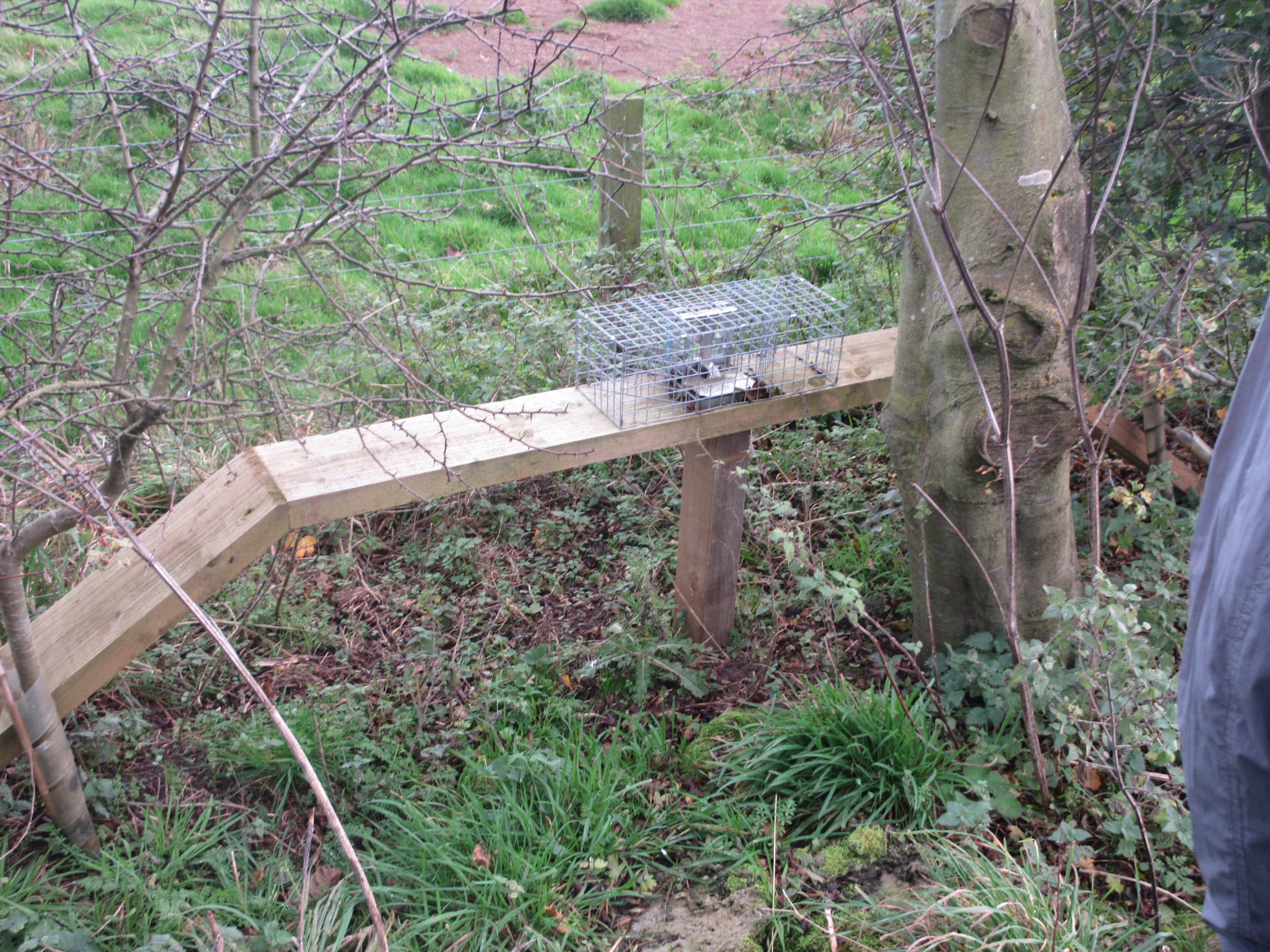
                      This is a conservation area. Not sure but there are hints of pheasant rearing. This is a vermin trap to catch weasels and anything else that might take a young pheasant.
                             Marked on the map as Observatory
                  There are point to point races held here. The hurdles stored out of the way for now, presumably

                          Bug Hotel?
The road through the farm seems to go on for ever. At one point it turns off to the right. At this point we took the path down the left side of the hedge, crossed several fields and came to a track alongside the railway. 

               The track passes the old station buildings, someone has a sense of humour.
At the end of the rough track, which isn't too bad we hit the road, turned left and walked back to Lesbury, the cars and home. No pub, lockdown.

This walk is about 9.5 miles, easy going on tracks and footpaths. Well worth doing.

                   Contains OS data, copyright. Crown copyright and data base right 2020


Wednesday, 11 November 2020

 Way down upon the sWannee  River. (Northumberland) November 10th.

For a midweek outing four of us have chosen a flat walk along the banks of the River Wansbeck and the beach to Newbiggin by the Sea. 

Brian, Margaret, Dave and I met at West Sleekburn in Northumberland. Easy to find, head north on the A189 and turn off at the sign post. We parked at the side of the road very near the mineral line that goes through West Sleekburn to Ashington.

                Not a contender for car park of the year. On a previous occasion we parked next to the signal box below but the railway engineers got there before us. the lady of the house next to the car suggested we park there for the day and also on future occasions. Northern folk are so friendly.

There is no need for a map but the walk is covered by OS Explorer 325 Morpeth and Blyth.

Ready to go we walked, in twos as lockdown rules suggest, east for a short distance and turne left at the second street, heading down towards the river. On the river bank footpath we turned west and joined a number of dog walkers on the footpath.

                              Railway bridge. There are efforts to reopen this line to passenger traffic from Ashington to Newcastle.
                                      River Wansbeck

The footpath is close to the river, we walked under the railway bridge and a road bridge. beyond the road bridge the footpath leaves the riverside and climbs up to a housing estate. Having found our way through the streets we found the stairs down the bank through a small park and on to the road at Sheepwash. 

                          Sheepwash Bridge.  Nothing mysterious about the name, exactly what it says.
Once across the river we also crossed the road and joined the footpath on the north side of the water.

                  Dave and Brian thought they saw a kingfisher here. It had gone by the time I arrived. probably as well, I have a reputation with kingfishers.
From here the footpath simply follows the river, passing a caravan site, the Cambois Rowing Club HQ and the edge of the town of Ashington on its way to the sea.


                                 Life on the Wansbeck.
At the popint where the path goes under the A189 we joined the English Coastal Path. Next to the road bridge is a footbridge which leads to a walk to Cambois.
Beyond the A189 we left the ECP and walked on firm sand round the headland before scrambling up into a caravan park, finding the ECP again and walking north.
                               Wansbeck Estuary

                                  Distant view of Blyth harbour area.
The footpath follows the cliff tops towards Newbiggin crossing a couple of fields and giving a glimpse of a coal seam.


                      Shells and a seam.
Near Spital Point we called a Herbie and sat in a small car park to share Skimpy chocolate bars, Battenburg slices, and savoury flapjack and almond cake from Mrs A.
Lunch over we continued north to the town, walked down onto the promenade in the direction of St. Bartholomew's church at the end of the bay.
                                Newbiggin Bay
                               Newbiggin couple watching out to sea
                                    I never knew that
                               Model of the sea watching couple

                          St Bartholomew's. Possible 13th century origins with 19th century renovations.
At this point my knee was beginning to bother me so I caught a bus back to West Sleekburn. The other three continued north to the power station at Ellington before heading towards Ashington from where they caught a bus too.

My walk was 8.2 miles, the other three walked a noble 13.7

Contains OS data, copyright. Crown copyright and database right 2020

A couple more;


Thursday, 5 November 2020

 This could be the last time..........................

Northumberland November 4th.

England enters a second lockdown on November 5th. Six of us are having a walk out before group activities are banned. John H., John L., Brian, Dave, Margaret and I are meeting in Warkworth for a coastal walk. 

The map for the walk is OS Explorer 332 Alnwick and Amble but is not essential, it's an easy walk to follow.

To get to Warkworth follow the Coastal Route A189 which becomes the A1068 through several villages and the small port of Amble. Turn right at the top of the hill near the castle and head down. Turn into the car park, go past the church and park on the riverside.

Warkworth is a gem of a small Northumberland town, dominated by the castle which dates to the 11th century but was mostly built in the 14th by the Percy family, one being he of Harry Hotspur fame. 

The church near the river, dedicated to St Laurence is an almost completely Norman church, 12th century. Across the river Coquet is the hermitage, accessible by ferry and also from the 14t century.

And to finish off, the bridge, now only for pedestrians is also 14t Century.

For breakfast we went to  Bartrams, great little cafe on the main road. Tea, coffee, bacon sandwiches, sausage sandwiches.

                       Warkworth Castle Keep.
  Booted up we left the car park and headed east along the riverside footpath towards the bridge.


              Today's car park 

                   The modern road bridge is just behind this pack horse construction.
Once over the bridge we went over the road and headed uphill towards the car parks near the beach. There is a footpath on the right hand side which goes along the edge of a field and is nicer than walking the tarmac. As we approached the dunes behind the beach we turned right and walked along a track towards the river Mouth. (River Coquet) Dave and Brian walked to the end of the north pier but the rest of us, having scrambled over a few rocks, headed north on the beach.
Alnmouth Bay, the tide was out, we had acres of sand to play on. There were few other walkers.
Apart from the rocks at Birling Carrs there is nothing but sand all the way to Alnmouth, mostly quite firm and easy walking. As we approached the river Aln, which is occasionally so low you can walk across to the village, we turned west and climbed the small hill overlooking the estuary. Down the hill are the ruins of a Norman Chapel, a good Herbie Spot.
                                               Alnmouth
                         Norman chapel and shadow of photographer. Apparently this chapel used to be in the village but a violent storm in 1806 caused the river to change direction and isolate the building.

                       Herbie time and shadow; Titans, ginger biscuits, almond slices, flapjacks, sweet and savoury from Mrs A.
Lunch over we set off back to Warkworth, following the track that goes just behind the dunes.
          By the time we returned the tide had come in. Walking the beach may have been problematic.
                   At this point the footpath crosses the golf course and dips under a bridge  

                                      Safety first, don't want to be hit by a flying golf ball.
We reached the track back into Warkworth and the cars, repeating our steps across the old bridge and going through the ancient gate.

                                           Gate and bridge beyond

                                Autumn on the Coquet.
We headed inland to the Cook and Barker for a last drink  before pubs close for the lockdown. Sadly they had run out of Timothy Taylor's Landlord.

                            Contains OS data copyright. Crown copyright and database right 2020.
  For four of us this walk was about 9.3 easy going miles. For Dave and Brian it was 10 as they went to the end of the pier.

A few more Autumn photos.