Belford, Beacons, Bays and Bamburgh...Nov 20th.(Northumberland)
Belford is a village in north Northumberland with a population of about 1500, a church dating back in parts to the 13th century, several pubs and a small railway station. The name means either "Bella's Ford, "settlement on a bell shaped hill" or " a glade near swampy ground. Take your pick. It is however the starting line for today's walk, a p;opular one covered several times in the blog but never in The Times "A good Walk". The forecast has once more postponed the trip to Teesdale, or even the Northumbrian hills. The second storm has been, the Met Office called it Barney because they thought it might produce some rubble!
It's a real gadgie walk because we are driving to Seahouses and catching the X18 or 418 to Belford. An infrequent service if you want to uise it, check timetables available on the Nexus site.
To get to Seahouses, A1 north beyond Alnwick, turn east and follow signposts on minor roads. There is a large car park on the site of the old railway station, a gear shop in case you have forgotten your socks, and several fish and chip shops.
The team today; John C., Brian. Ray, Harry, Dave and me the blogmeister. Which reminds me, I got a note from a gentleman who liked the interesting but redundant gate post last week. He directed me to photos of several others near Skipton in Yorkshire in the area I was born. There were also some Green Lane markers (qv). Dave the archaeologist was interested too.
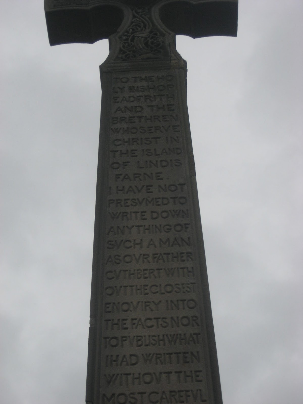
I have no idea why it turned blue.
Should you need a map for the walk the one to use OS Explorer 340 Holy Island.
We arrived in time for tea at Trotters Bakery and Cafe on Seahouses High Street, a bacon sandwich was awarded 3.5 flitches, the tea was fine and the staff were friendly. We caught the 11am bus and got off at the Golfclub in Belford to start the walk.

Belford main street, St Mary's church.
A sign post for St. Oswald's Way (again!) pointed us on our way alongside Belford Burn, next to the golf course. Soon we came to the A1, major road on the east side of Britain between London and Edinburgh.
 The A1 in a quiet moment. A single carriageway. Had it been in the south it would have been duelled years ago if not upgraded to motorway standards, but it is in the north so it doesn't matter. Perhaps the conservative MP for the area can persuade the government to get on with improving it.
Across the road we followed the footpath alongside the grain silos, Northumberland is an agricultural county producing wheat, barley and root vegetables, plus a few leeks for show.
 The silos near Belford. There is a heating system to dry the the crop, Brian feels it goes against the grain and he should know, he studied agriculture.
In the field by the silos was an interesting but small flock of sheep, possibly Jacob's, or maybe belonging to somebody else.
 Jacob's sheep.
Next stop the railway; it is the main line between London and Edinburgh and there is a pedestrian crossing here. You are asked to use the phone by the gate to ask permission to cross, we did, and once over we phoned from the other side to tell the signalman we were safely over the lines.
The footpath crosses a stretch of old and rusty track that once served the nearby Easington Quarry, crosses a couple of fields in a very straight line and emerges at a minor road. On previous occasions we have followed the road to the right past the dovecot but today we turned left, leaving the holy man's way and walked down the road a short distance.

A distant view of the Outchester Ducket or dovecot. Built for feed storage and for keeping doves it is now a holiday cottage.

The ducket on a sunny day. It may, says the archaeologist, be built on the site of a Roman Camp.
Near a cottage we found the sign post on the right leading us to Waren Mill.
 Sign post for Waren Mill.
The footpath crosses a couple of fields, muddy today like most of the fields we have crossed before coming to the road at the mill.
Waren Mill is ancient, a plaque on the wall says it had links to Bamburgh Castle and gets its first mention in 1187. originally water powered it started to use steam in 1819. being close to Budle Bay it could import coal and export milled grain. It finally closed as a mill in 1984 and is now a block of flats, sorry, luxury apartments.
 Waren Mill
 Budle Bay on a grey day with the tide out and lots of ducks on the mudflats. North of Budle Bay on Ross Sands there is a Naturist Beach, probably too cold for that today! And beyond that are two stone built Navigation Towers, 500 feet apart, built between 1820 and 1840.
 Navigation towers north of Budle Bay. They are 500 feet apart. I have tried to explain to my wife that this can not be exact because it is continuous and not discrete but she says I am being silly.
Just beyond the hamlet we went through a gate onto the shore and walked along the soft sand for a couple of miles before we came to a derelict pier which made a fine shelter against the cold north west wind. We declared a Herbie Spot.
 A bit low on treats today, almond slices, flapjacks from www.cakepoppins.co.uk and chocolate and beetroot muffins from Mrs A. There are still some who will not join in the exchange of goods. Shame on them.
Break over we continued along the beach, rounding Budle Point and passing the light at Blackrocks Point. Stag Rock is nearby, so called, according to Brian in a long rambling tale, because it was painted in the days of King Arthur bu Lancelot when, on his wedding eve, he invented the stag party.
 The light at Blackrock Point
 An early work by Sir Lancelot, impressionist style and minimalist in use of colour.
Rounding the point we came to the finest looking castle in Britain if not Europe, Bamburgh.
It has ancient foundations and a Norman Keep. It featured in a recent film of Macbeth and had a magnificent mountain painted in digitally behind it. The film was pretty good, the Scottish soldiers looked ill throven and badly dressed, not a Hollywood quif between them.

 Bamburgh Castle, Northumberland. Built on the Whin Sill it was a Saxon Fort, a Norman Keep and a film star.
Passing the castle we continued on the beach all the way into Seahouses where, having changed, we refreshed ourselves at the Olde Ship Inn which had a variety of beers, Speckled Hen, Directors, Theakstons, Farne Island and the cheeriest bar maid we have seen in years. Very much a locals pub, be careful where you sit.
Not a bad day for the birders, ducks, waders and a kestrel, but it was a windy day, best stay in your nest lads. Harry and Brian spotted the bird of the blog though, a little auk.


The Olde Ship Inn, Seahouses.
The Matrix MMXV YYYYY
steps miles
LIDL 3D 21405 8
Nakosite 21316 9.0
Dave's LIDL 3D 19205 9.4
"" USB 18716 9.15
Nakosite 18611 9.10
etrex 9.3
John C 9.44
Brian 9.1
Settle for 9.2


Contains OS Data, Copyright. Crown Copyright and Database right 2015
Belford is a village in north Northumberland with a population of about 1500, a church dating back in parts to the 13th century, several pubs and a small railway station. The name means either "Bella's Ford, "settlement on a bell shaped hill" or " a glade near swampy ground. Take your pick. It is however the starting line for today's walk, a p;opular one covered several times in the blog but never in The Times "A good Walk". The forecast has once more postponed the trip to Teesdale, or even the Northumbrian hills. The second storm has been, the Met Office called it Barney because they thought it might produce some rubble!
It's a real gadgie walk because we are driving to Seahouses and catching the X18 or 418 to Belford. An infrequent service if you want to uise it, check timetables available on the Nexus site.
To get to Seahouses, A1 north beyond Alnwick, turn east and follow signposts on minor roads. There is a large car park on the site of the old railway station, a gear shop in case you have forgotten your socks, and several fish and chip shops.
The team today; John C., Brian. Ray, Harry, Dave and me the blogmeister. Which reminds me, I got a note from a gentleman who liked the interesting but redundant gate post last week. He directed me to photos of several others near Skipton in Yorkshire in the area I was born. There were also some Green Lane markers (qv). Dave the archaeologist was interested too.
I have no idea why it turned blue.
Should you need a map for the walk the one to use OS Explorer 340 Holy Island.
We arrived in time for tea at Trotters Bakery and Cafe on Seahouses High Street, a bacon sandwich was awarded 3.5 flitches, the tea was fine and the staff were friendly. We caught the 11am bus and got off at the Golfclub in Belford to start the walk.

Belford main street, St Mary's church.
A sign post for St. Oswald's Way (again!) pointed us on our way alongside Belford Burn, next to the golf course. Soon we came to the A1, major road on the east side of Britain between London and Edinburgh.

Across the road we followed the footpath alongside the grain silos, Northumberland is an agricultural county producing wheat, barley and root vegetables, plus a few leeks for show.

In the field by the silos was an interesting but small flock of sheep, possibly Jacob's, or maybe belonging to somebody else.

Next stop the railway; it is the main line between London and Edinburgh and there is a pedestrian crossing here. You are asked to use the phone by the gate to ask permission to cross, we did, and once over we phoned from the other side to tell the signalman we were safely over the lines.
The footpath crosses a stretch of old and rusty track that once served the nearby Easington Quarry, crosses a couple of fields in a very straight line and emerges at a minor road. On previous occasions we have followed the road to the right past the dovecot but today we turned left, leaving the holy man's way and walked down the road a short distance.

A distant view of the Outchester Ducket or dovecot. Built for feed storage and for keeping doves it is now a holiday cottage.

The ducket on a sunny day. It may, says the archaeologist, be built on the site of a Roman Camp.
Near a cottage we found the sign post on the right leading us to Waren Mill.

The footpath crosses a couple of fields, muddy today like most of the fields we have crossed before coming to the road at the mill.
Waren Mill is ancient, a plaque on the wall says it had links to Bamburgh Castle and gets its first mention in 1187. originally water powered it started to use steam in 1819. being close to Budle Bay it could import coal and export milled grain. It finally closed as a mill in 1984 and is now a block of flats, sorry, luxury apartments.


Just beyond the hamlet we went through a gate onto the shore and walked along the soft sand for a couple of miles before we came to a derelict pier which made a fine shelter against the cold north west wind. We declared a Herbie Spot.

Break over we continued along the beach, rounding Budle Point and passing the light at Blackrocks Point. Stag Rock is nearby, so called, according to Brian in a long rambling tale, because it was painted in the days of King Arthur bu Lancelot when, on his wedding eve, he invented the stag party.


Rounding the point we came to the finest looking castle in Britain if not Europe, Bamburgh.
It has ancient foundations and a Norman Keep. It featured in a recent film of Macbeth and had a magnificent mountain painted in digitally behind it. The film was pretty good, the Scottish soldiers looked ill throven and badly dressed, not a Hollywood quif between them.


Passing the castle we continued on the beach all the way into Seahouses where, having changed, we refreshed ourselves at the Olde Ship Inn which had a variety of beers, Speckled Hen, Directors, Theakstons, Farne Island and the cheeriest bar maid we have seen in years. Very much a locals pub, be careful where you sit.
Not a bad day for the birders, ducks, waders and a kestrel, but it was a windy day, best stay in your nest lads. Harry and Brian spotted the bird of the blog though, a little auk.

Little Auk, nothing like the big ones in "Lord of the Rings"

The Matrix MMXV YYYYY
steps miles
LIDL 3D 21405 8
Nakosite 21316 9.0
Dave's LIDL 3D 19205 9.4
"" USB 18716 9.15
Nakosite 18611 9.10
etrex 9.3
John C 9.44
Brian 9.1
Settle for 9.2


Contains OS Data, Copyright. Crown Copyright and Database right 2015