ANIMALS ON TOUR 2014
After two years at The Logs, just north of Fort William* this years "gentlemen's" week of walking and dining and drinking and watching " Still Game"** we are off to stay at The Killin Highland Lodges which are two miles east of Killin on the north side of Loch Tay.
 Chalet 8 Killin Highland Lodges
Eight of us arrived on the afternoon of Saturday July 12th, complete with walking kit, food and 216 pints of beer made up from barrels of Tyneside Blonde, Lovely Nelly and Secret Kingdom. We also had a fruit cake for the week and some bread and stuff. And for evening entertainment DVDs of the above mentioned Still Game and Father Ted. Being pretentious I brought a copy of "War and Peace" and an ipod loaded with intellectual Lord Melvyn of In our Time Bragg episodes.
 This years cake from
www.cakepoppins.co.uk
 Oh the detail,
All qualified gadgies, Phil, Brian, Ray, Norman, Ben, John H, John C and i settled into our two lodges, set up the beer pumps and drove into the small town of Killin to make a few purchases at the local Co-op and have dinner at The Capercaillie Restaurant which boasted a limited menu and Belhaven Best. It was the only pint bought in a public bar for the next seven days.
All the walks in this blog can be followed and found on OS Landranger 51, Loch Tay and Glen Dochart.
SUNDAY JULY 13th
For the first stroll out of the week, to warm up so to speak, we drove north east along the A85 for a short way before turning left on to one of those narrow roads with passing places, tight bends and steep drops on either side past the Lochan na Lairige, which is damned at the south end, until we pulled into a parking place at GR NN 593415.

Ben, with cold hands, John H with hat, Norman
Phil and Ray, and a car park.
On the right side of the road a cairn marked the start of the walk, but finding the path was a bit of a problem. John C had uploaded the route onto his GPS and led off, followed byNorman Ben and Phil.
Ray, Brian, John H and I took a slightly different path and within minutes had lost sight of the others. However we soldiered on across boggy territory looking out for the other party but to no avail. They were lost, with or without a GPS. We followed a trail, partly made up, in a north east direction before climbing up the side of Coire Gorm and turned north on a path to the summit of Meall a Choir Leith. (3038 ft) ( I do not know how to pronounce it either). On the summit I noticed the heel of my boot was working loose. I do not expect this from Meindl boots and shall take them back.
 Phil rests before we start
 The Searchers
 The target

My GPS claimed a distance of 6.37 miles and LIDL 3D a disappointing 5.85, I need Dave to offer technical assistance.
INFO, something new! Total climb 2444.1 feet
Duration 3 hours 53 minutes, excluding stops.
Personal distance 6.37 miles
 As we are in Scotland they have become McHerbie Spots andthis one is in the wrong
place. It should be near Coire Liath
On the return journey we went to Stutters Restaurant in Killin for tea and scones.
Back at the chalets we all piled into number 9, after showers and changing of course, where we were treated to "Botham burgers", the size and shape of a cricket ball and too big for the bun, salad and chips, followed by sponge cake and custard, a Geordie speciality since I first came to the North East in 1964. It's the way they say it. Thanks for the meal Phil.
 John taps a barrel of Secret Kingdom.
That evening we watched the World cup Final and drank a few.
MONDAY JULY 14th
The weather forecast threatened rain early in the afternoon so we opted for a shortish walk, following the A85, turning on the same road as Monday but continuing to Bridge of Balgie where we turned left then after three miles turned right and parked by the dam at Lochan Daimh GR NN 511463
 Today's car park and dam
 and a worrying sign
From the car park (and wearing my spare but old boots) we followed the track a short way before turning off on the right following a path of sorts through the boggy bits, over Coire nam Miseach and on to Meall Buidhe (3058 feet). The views from the top were worth the soggy climb but the clouds were coming in and as we lunched the rain began to fall, like Scottish rain, wet and wind driven. Hurriedly donning waterproofs we retraced our steps. Not having bothered with waterproof trousers I was soaked through from my waist down. Only myself to blame.
INFO Total climb 1804 feet
Distance (GPS) 5.38 miles
Duration 2 hours 32 mins
Personal distance 11.75 miles
Back at the lodges, showered, dried and with sodden clothes spread round to dry we retired to chalet 9 which has become the dining room, and fed on a great corned beef pie, potatoes, vegetables, wine and for afters a slice of the cake visible at the beginning of this blog. And Paul arrived!
 Loch Daimh
 The rain approaches
 Ben, Phil and John H before the weather changed.

TUESDAY JULY15th
With the promise of good weather we headed back in the direction of Lochan na Lairige and parked in the Ben Lawers car park a mile south of the dam. The Scottish National Trust are more generous than their English counterparts and charge a mere £2 for a day. ( GR NN608377)
 Ben Lawers car park.
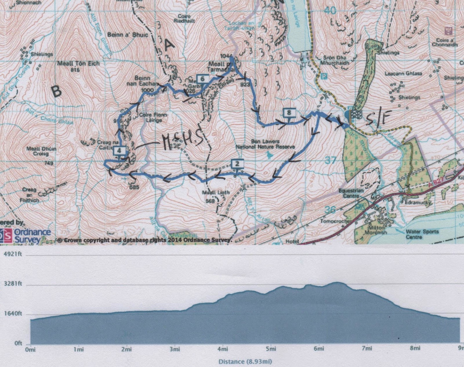
Ben had a copy of Storers 100 best Scottish Walks which describes today's walk, The Tarmachan Ridge as an anti clockwise walk, but being wise and hoping to have the wind at our backs we chose the opposite direction, (Or are we perverse?)
Leaving the park by a footpath and crossing a stream by means of a footbridge we came to a good track and turned left. Following the track we passed eight intakes, something to do with the water works and dams in the area.
 A brief rest at an intake.
The track headed west, climbing steadily until, at intake number 8 it became a footpath and a steep climb around the south end and then to the top of the first summit, Craig na Caillich, the old woman's crag. Sheltering behind rocks we declared a brief McHerbie Spot before pushing on to the base of Beinn nan Eachan, Mountain of the Horse, (3280 feet) where we had a more serious McH S before climbing the steep crag. Climbing to the next peak, Meall Garbh, the rough hill,(3366 feet) there was a bit of a scramble, not exactly the Hillary Step, but a little interest. From there we walked to the last peak on the round, Meall Tarmachan, the Ptarmigan hill ( 3425 feet). From here a good path led south downhill before turning east back to the car park.
INFO Total climb 2888 feet
Distance 9.84 miles
Duration 5 hours, 4 mins
Personal total 21.59 miles
 Loch Tay and Killin
 The Rocky Road
 Meall Garbh
 Part of the Tarmachan Ridge walk
 A quality stile.
WEDNESDAY JULY 16th
The weather man did not lie, it was raining when we got up and it continued to fall for most of the day so we declared it a rest day. Some went off to Stirling to study the young students and four of us, Ben, Phil, John H and I went to Kenmore in search of some local history and visited the Crannog.
A Crannog was an iron age settlement built on a small but real or artificial island. There is evidence that there are eighteen of them around Loch Tay. The one we visited has been carefully reconstructed using the correct timbers, mainly Alder, for the piles and roof supports. The "island" is surrounded by hazel hurdles and the building itself is big enough to hold about twenty inhabitants and a few sheep.
A guide took us in, we were seated on benches in a circle and he explained the whole life system of these iron age Crannog dwellers. Interestingly, although they lived on a lake fish was not part of their diet, or more correctly fish bones have never been found, just animal bones. The roof would have been thatched with bracken which was also used for making ropes and for insulation.
Back on land we were given a demonstration of iron age lathes and fire making with a stick turned at speed on wood. It worked too. There was an exhibition of plants and an explanation of their medicinal values. All very interesting.
 The fire place, there was no hole in the
centre of the roof for smoke to escape
 The Crannog
 Lathes
 Phil and John H work the lathe
 Man makes fire
 and makes holes in stones to weigh down warps on
looms
 The pharmacy
 The Crannog
That evening we dined on a vegetable and chicken curry followed by a cheese plate and a plentiful supply of port. Thanks John H
Sadly John C had to go home because his mother was unwell.
THURSDAY JULY 17th
Decent walking weather has returned. We have planned another round from Invervar, climbing Carn Gorm and a few other bumps. We took the A85 east, crossed over to the Bridge of Balgie and turned right for Invervar. Opposite Invervar Lodge is a small car park, room for six at GR NN666482.
 Off road parking at Invervar
Walking a short distance west along the road we came to a sign asking us to use the path by the Lint Mill, which we did. Passing the little old mill the path, which has orange markers, crossed a field before entering a wood.
 The old Lint Mill, used for storage apparently.
The path followed the Invervar Burn alongside a wood before emerging on to grassland and climbing steeply in a westerly direction to the summit of Carn Gorm (3012 feet) where we sat and enjoyed a McHerbie Spot. It was very hot and humidity was high, John and I decided that we would retrace our footsteps down to the car rather than complete the whole round. We wandered slowly back down the hill, sitting in the sun to enjoy the view of Glen Lyon.
The brave souls who continued the whole round walked 12 miles, a long day out on a hot day as it took them eight exhausting hours.
 Bridge on the Invervar Burn
 Carn Gorm in the distance
 McHerbie Spot on the top
 My first selfie!, Or is it Edmund Hillary?
 Determined Ray and Ben
 Glen Lyon

Waterfall on the Invervar Burn
INFO Total climb (me and John H) 2375 feet
Distance (me and John) 7.4 miles
Personal Distance 29.29 miles

Contains OS data Copyright and data base right 2014
Solid line route followed by John and me. dotted line the complete round for Brian, Phil, Paul, Ray, Norman and Ben.
That evening we dined on a chilli from Paul followed by more cheese and biscuits. Thanks Paul, it was excellent.
FRIDAY JULY 18th
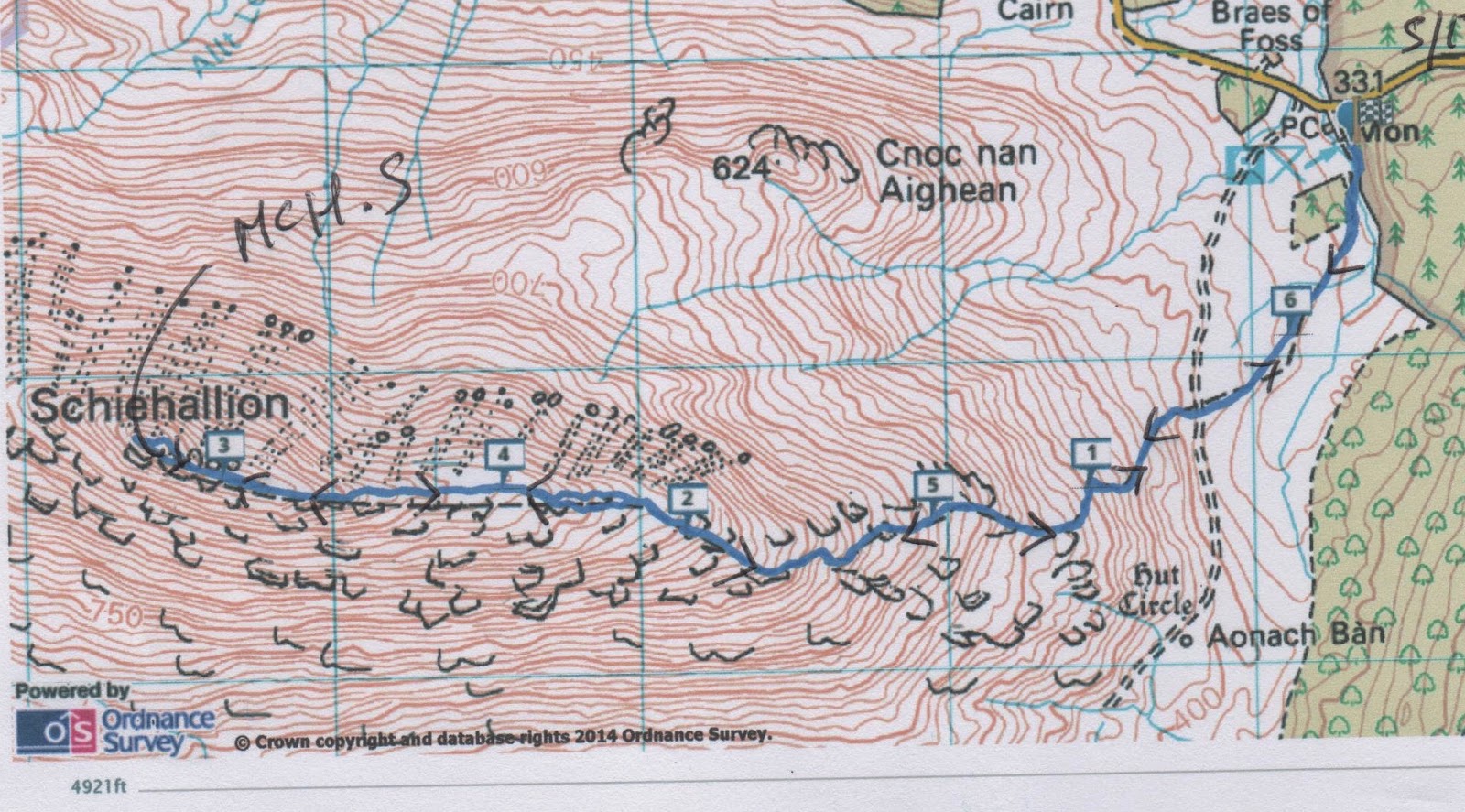
My parents have had a watercolour of Schiehallion on their living room wall for about fifty years so I was pleased that the last walk of the week was to be another "up and down " on the "Mountain of the Fairies". From the north west it looks like a cone, from the Braes of Foss where we started it is more dome shaped. To get there we drove east on the A85, turned left for Fortingall, left again at Coshieville and left again at the sign that pointed to Schiehallion. The car park, which boasts an LPG toilet, something I haven't seen since 1966, and a broken parking meter is at GR NN753556.
 Last car park of the week!
There is a well made path leading from the south end of the car park which leads to the "first" summit cairn on the mountain. From here the path crosses the stones and boulders which cover the whole summit and make walking a little difficult in that you need to watch nearly every step. The highest point (3553 feet) was covered in low cloud when we arrived but it lifted enough to show Loch Rannoch to the north west.
 Norman and John dine at McHerbie's on
the rocky top of Schiehallion
 Schiehallion summit
 The path near the summit
 and on the lower slopes, much easier walking
 Schiehallion from the car park at Braes of Foss
It turned quite cold as we ate at the McH S and rather than hang around we repacked, donned extra lagging and headed down the same way after another good walk out.
INFO Total climb 2402 feet
Distance 6.44 miles
Duration 3 hours 28 minutes
Personal Total 35.73 miles

* See "Seven little gadgies go walking in the hills July 2013" and " A gallon of Gadgies... July 2012"
** An hilarious Scottish sit com from the 2000s about two gadgies.
*** An equally hilarious sit com about three priests in Ireland.
Gadgie distance 299
After two years at The Logs, just north of Fort William* this years "gentlemen's" week of walking and dining and drinking and watching " Still Game"** we are off to stay at The Killin Highland Lodges which are two miles east of Killin on the north side of Loch Tay.
Eight of us arrived on the afternoon of Saturday July 12th, complete with walking kit, food and 216 pints of beer made up from barrels of Tyneside Blonde, Lovely Nelly and Secret Kingdom. We also had a fruit cake for the week and some bread and stuff. And for evening entertainment DVDs of the above mentioned Still Game and Father Ted. Being pretentious I brought a copy of "War and Peace" and an ipod loaded with intellectual Lord Melvyn of In our Time Bragg episodes.
www.cakepoppins.co.uk
All qualified gadgies, Phil, Brian, Ray, Norman, Ben, John H, John C and i settled into our two lodges, set up the beer pumps and drove into the small town of Killin to make a few purchases at the local Co-op and have dinner at The Capercaillie Restaurant which boasted a limited menu and Belhaven Best. It was the only pint bought in a public bar for the next seven days.
All the walks in this blog can be followed and found on OS Landranger 51, Loch Tay and Glen Dochart.
SUNDAY JULY 13th
For the first stroll out of the week, to warm up so to speak, we drove north east along the A85 for a short way before turning left on to one of those narrow roads with passing places, tight bends and steep drops on either side past the Lochan na Lairige, which is damned at the south end, until we pulled into a parking place at GR NN 593415.
Ben, with cold hands, John H with hat, Norman
Phil and Ray, and a car park.
On the right side of the road a cairn marked the start of the walk, but finding the path was a bit of a problem. John C had uploaded the route onto his GPS and led off, followed byNorman Ben and Phil.
Ray, Brian, John H and I took a slightly different path and within minutes had lost sight of the others. However we soldiered on across boggy territory looking out for the other party but to no avail. They were lost, with or without a GPS. We followed a trail, partly made up, in a north east direction before climbing up the side of Coire Gorm and turned north on a path to the summit of Meall a Choir Leith. (3038 ft) ( I do not know how to pronounce it either). On the summit I noticed the heel of my boot was working loose. I do not expect this from Meindl boots and shall take them back.
Lochan na Lairige, plus dam
We retraced our path towards Coire Leith where, surprise, surprise, we met the other four and lunched together. Both parties doing the same walk but in different directions. Feeding over we four continued to walk up Meall Corranaich (3507 feet). From there a good path took us south west then north west and back to the car where we shortly joined by the anti- clockwisers.My GPS claimed a distance of 6.37 miles and LIDL 3D a disappointing 5.85, I need Dave to offer technical assistance.
INFO, something new! Total climb 2444.1 feet
Duration 3 hours 53 minutes, excluding stops.
Personal distance 6.37 miles
place. It should be near Coire Liath
On the return journey we went to Stutters Restaurant in Killin for tea and scones.
Back at the chalets we all piled into number 9, after showers and changing of course, where we were treated to "Botham burgers", the size and shape of a cricket ball and too big for the bun, salad and chips, followed by sponge cake and custard, a Geordie speciality since I first came to the North East in 1964. It's the way they say it. Thanks for the meal Phil.
That evening we watched the World cup Final and drank a few.
MONDAY JULY 14th
The weather forecast threatened rain early in the afternoon so we opted for a shortish walk, following the A85, turning on the same road as Monday but continuing to Bridge of Balgie where we turned left then after three miles turned right and parked by the dam at Lochan Daimh GR NN 511463
From the car park (and wearing my spare but old boots) we followed the track a short way before turning off on the right following a path of sorts through the boggy bits, over Coire nam Miseach and on to Meall Buidhe (3058 feet). The views from the top were worth the soggy climb but the clouds were coming in and as we lunched the rain began to fall, like Scottish rain, wet and wind driven. Hurriedly donning waterproofs we retraced our steps. Not having bothered with waterproof trousers I was soaked through from my waist down. Only myself to blame.
INFO Total climb 1804 feet
Distance (GPS) 5.38 miles
Duration 2 hours 32 mins
Personal distance 11.75 miles
Back at the lodges, showered, dried and with sodden clothes spread round to dry we retired to chalet 9 which has become the dining room, and fed on a great corned beef pie, potatoes, vegetables, wine and for afters a slice of the cake visible at the beginning of this blog. And Paul arrived!
TUESDAY JULY15th
With the promise of good weather we headed back in the direction of Lochan na Lairige and parked in the Ben Lawers car park a mile south of the dam. The Scottish National Trust are more generous than their English counterparts and charge a mere £2 for a day. ( GR NN608377)
Ben had a copy of Storers 100 best Scottish Walks which describes today's walk, The Tarmachan Ridge as an anti clockwise walk, but being wise and hoping to have the wind at our backs we chose the opposite direction, (Or are we perverse?)
Leaving the park by a footpath and crossing a stream by means of a footbridge we came to a good track and turned left. Following the track we passed eight intakes, something to do with the water works and dams in the area.
The track headed west, climbing steadily until, at intake number 8 it became a footpath and a steep climb around the south end and then to the top of the first summit, Craig na Caillich, the old woman's crag. Sheltering behind rocks we declared a brief McHerbie Spot before pushing on to the base of Beinn nan Eachan, Mountain of the Horse, (3280 feet) where we had a more serious McH S before climbing the steep crag. Climbing to the next peak, Meall Garbh, the rough hill,(3366 feet) there was a bit of a scramble, not exactly the Hillary Step, but a little interest. From there we walked to the last peak on the round, Meall Tarmachan, the Ptarmigan hill ( 3425 feet). From here a good path led south downhill before turning east back to the car park.
INFO Total climb 2888 feet
Distance 9.84 miles
Duration 5 hours, 4 mins
Personal total 21.59 miles
Back at the chalet we dined on pasta, washed down with wine followed by Ben's home made ice cream and desert wine.
The evening's entertainment was "Still Game"
WEDNESDAY JULY 16th
The weather man did not lie, it was raining when we got up and it continued to fall for most of the day so we declared it a rest day. Some went off to Stirling to study the young students and four of us, Ben, Phil, John H and I went to Kenmore in search of some local history and visited the Crannog.
A Crannog was an iron age settlement built on a small but real or artificial island. There is evidence that there are eighteen of them around Loch Tay. The one we visited has been carefully reconstructed using the correct timbers, mainly Alder, for the piles and roof supports. The "island" is surrounded by hazel hurdles and the building itself is big enough to hold about twenty inhabitants and a few sheep.
A guide took us in, we were seated on benches in a circle and he explained the whole life system of these iron age Crannog dwellers. Interestingly, although they lived on a lake fish was not part of their diet, or more correctly fish bones have never been found, just animal bones. The roof would have been thatched with bracken which was also used for making ropes and for insulation.
Back on land we were given a demonstration of iron age lathes and fire making with a stick turned at speed on wood. It worked too. There was an exhibition of plants and an explanation of their medicinal values. All very interesting.
centre of the roof for smoke to escape
looms
That evening we dined on a vegetable and chicken curry followed by a cheese plate and a plentiful supply of port. Thanks John H
Sadly John C had to go home because his mother was unwell.
THURSDAY JULY 17th
Decent walking weather has returned. We have planned another round from Invervar, climbing Carn Gorm and a few other bumps. We took the A85 east, crossed over to the Bridge of Balgie and turned right for Invervar. Opposite Invervar Lodge is a small car park, room for six at GR NN666482.
Walking a short distance west along the road we came to a sign asking us to use the path by the Lint Mill, which we did. Passing the little old mill the path, which has orange markers, crossed a field before entering a wood.
The path followed the Invervar Burn alongside a wood before emerging on to grassland and climbing steeply in a westerly direction to the summit of Carn Gorm (3012 feet) where we sat and enjoyed a McHerbie Spot. It was very hot and humidity was high, John and I decided that we would retrace our footsteps down to the car rather than complete the whole round. We wandered slowly back down the hill, sitting in the sun to enjoy the view of Glen Lyon.
The brave souls who continued the whole round walked 12 miles, a long day out on a hot day as it took them eight exhausting hours.
Waterfall on the Invervar Burn
INFO Total climb (me and John H) 2375 feet
Distance (me and John) 7.4 miles
Personal Distance 29.29 miles
Solid line route followed by John and me. dotted line the complete round for Brian, Phil, Paul, Ray, Norman and Ben.
That evening we dined on a chilli from Paul followed by more cheese and biscuits. Thanks Paul, it was excellent.
FRIDAY JULY 18th
My parents have had a watercolour of Schiehallion on their living room wall for about fifty years so I was pleased that the last walk of the week was to be another "up and down " on the "Mountain of the Fairies". From the north west it looks like a cone, from the Braes of Foss where we started it is more dome shaped. To get there we drove east on the A85, turned left for Fortingall, left again at Coshieville and left again at the sign that pointed to Schiehallion. The car park, which boasts an LPG toilet, something I haven't seen since 1966, and a broken parking meter is at GR NN753556.
There is a well made path leading from the south end of the car park which leads to the "first" summit cairn on the mountain. From here the path crosses the stones and boulders which cover the whole summit and make walking a little difficult in that you need to watch nearly every step. The highest point (3553 feet) was covered in low cloud when we arrived but it lifted enough to show Loch Rannoch to the north west.
the rocky top of Schiehallion
It turned quite cold as we ate at the McH S and rather than hang around we repacked, donned extra lagging and headed down the same way after another good walk out.
INFO Total climb 2402 feet
Distance 6.44 miles
Duration 3 hours 28 minutes
Personal Total 35.73 miles
Back in Killin we returned to Shutters Restaurant for tea and cakes before heading back to the chalets for a last supper. John C had left a huge pan full of chicken and lemon grass and rice and we had some ice cream left.
The evening entertainment was several episodes of "Father Ted"***
SATURDAY JULY 19th
Everybody was up reasonably early to pack and tidy up. The last few pints of the third barrel had, sadly, to be poured away but there wasn't much left of the 216 pints we had brought. Farewells all round, farewell to Colin the site manager who hoped to see us again, and off we went after another great week away walking in Scotland. Thanks to the Chairman, secretary and treasurer, keep up the good work.
And I never read a word of Tolstoy's masterpiece!
** An hilarious Scottish sit com from the 2000s about two gadgies.
*** An equally hilarious sit com about three priests in Ireland.
Gadgie distance 299


