Waterloo and Cowstand July 12th
Back on the track after a couple of weeks off. Holidays!
Brian, Margaret, JohnC and I off for a local walk from Stamfordham, a village to the west of Newcastle.
The map for the walk is OS Explorer 316 Newcastle upon Tyne
Stamfordham is a "long village" with a large green separating the two sides. On the green is a
The Butter Cross, built in 1735 as a market area I suppose.
And an
Early 19th century Lock Up for the naughty folk of the area.
And the church of St. Mary,
Possibly Saxon origins but mostly 13th Century.
And of course there is car parking, free.
Parking just off the green.
The walk, at last.
We started the day going through the church graveyard on the south side of the building to find the gate at the beginning of the walk. From there we crossed fields, walked farm tracks and slices of road passing several farms and missing the ruins of a medieval village at East Matfen before reaching the slightly more modern village of Matfen.
Although we had only walked about 3.5 miles a bench and table outside the village store and coffee shop seemed a good place for a Herbie. (Apple pies, chocolate biscuits and sweet and savoury from Mrs A.)
Matfen is a very pretty village. A large green being the centre of an "estate village". Holy Trinity church is 19th century.
Matfen village green Holy Trinity Church.Over lunch we discussed the rest of the day. The original walk was just over 10 miles but it was suggested that we could make it 11 with a little extension. Somebody who shall remain nameless said "Let's go for the biggy" and so we did.
At the west end of the green (mile 4) we had originally planned to walk to Low Hall and then across fields to Waterloo. With a changed plan we took the road north from Matfen and at the first junction found the stile into fields covered in hawthorn so we climbed the fence and headed across a field full of long grass, much of which was flattened. Following the grass we walked across a field of young swedes, passing the ruin on the map which was one stone house end. We walked round the edge of a field of barley although the official right of way crosses it. Next a field of rye until we reached the road at Ryal. We scambled over a tumbledown wall to get on to the road.
Not exactly a field of gold but heading that way. The church at Ryal, 12th century chapel of ease, rebuilt in 1870 One of the many horses in the area. From Ryal we walked east, turned left at the next junction and headed for Ingoe, a hamlet with a bench and table for a mini Herbie. There is a "Warrior Stone " on South Hall farm but we missed it.
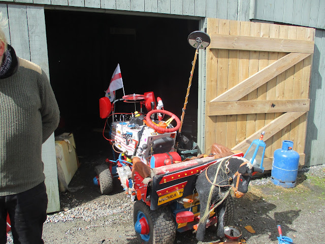
From Ingoe we walked the road east to North Fens where the retired farmer showed us his entry for a coming fair.
Nora, built from an old motorised grass cutter. And he was restoring a convertible Rolls Royce!
Leaving North Fens we walked south to South Fens, turned left at the finger post and headed east towrds Cowstand (mile 10). The footpath through the wood had a welcome sign:
However we walked through the wood which had lost a number of trees recently.
It was a bit of a struggle getting through.
At Cowstand we should have turned south, crossing more fields of barley to Westerheugh and beyond. But not wishing to go round more field edges we walked the farm track to the B6309 road, turned south and headed back to Stamfordham,
Contains Os data, copyright. Crown copyright and database right 2024
The walk is 12.5 miles. Easy going with little climbing but beware of fields of barley


No comments:
Post a Comment