The Doors, (Northumberland ) October 25th.
After a break of two weeks entertaining the colonials I am rejoining the team. Nine of us are going on a variation of the popular walk from Belford in Northumberland. (John x 3, Brian, Harry, Dave, Ben, Ray and me.) Belford is easy to find, straight up the A1 in the direction of Scotland and turn left at the road into the small town. Breakfast at Sunny Hills farm shop just before the town.
 Sunny Hills, farm shop, restaurant, classy
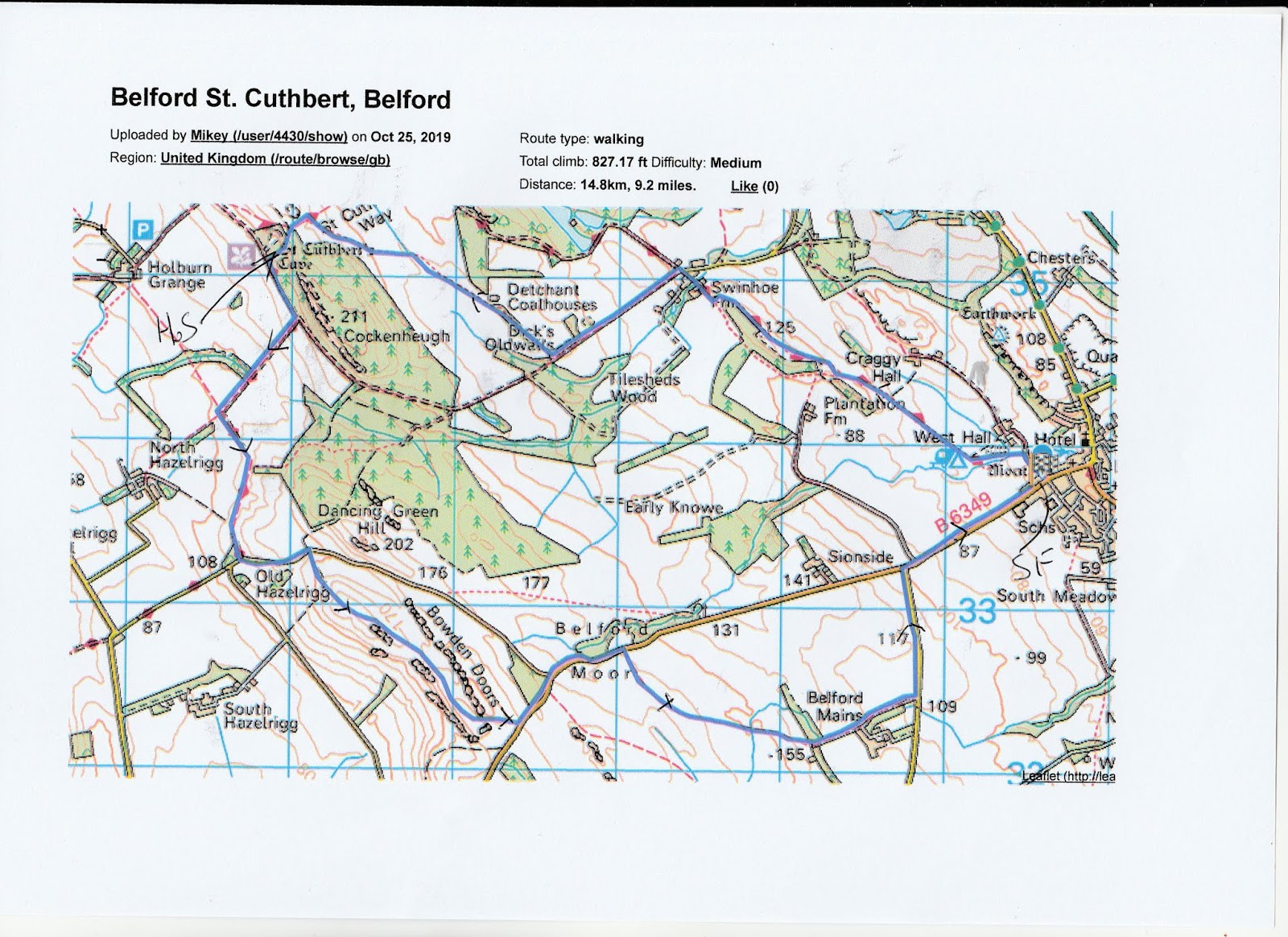
The map for the walk is OS Explorer 340 Holy Island and Bamburgh.
The forecast is not too promising, the gentleman from BBC North East and Cumbria suggests heavy rain in the afternoon by which time we may be in the pub.
The walk starts from the parking area by the Community Hall on the road to Wooler, just off the Belford main street.
 Not really a car park but space for several cars by the Community Hall. On the left of the hall is a lane: walk starts here.
The lane is part of the Northumberland Coast Path, St Oswald's Way. After a few hundred yards a gate on the left took us to a path alongside a stream close to Westhall, an old, fascinating farm house.
 Narrow footpath by a narrow stream
 close to Westhall.
The footpath, muddy today, goes in almost a straight line north west to Swinhoe Farm.
At the farm there is a cross roads of tracks, we took the left hand , no longer with St. Oswald but heading towards Cuthbert's Cave. However, at the delightfully named Dick's Old Walls we turned right through a gate. The footpath keeps close to the fence of a plantation and eventually emerges int fields.
Still heading roughly north west we eventually joined St. Cuthbert's Way. (The saint whose body was carried round Northumbria until it reached the spot that is now Durham Cathedral.)
Crossing into the wood we walked the short but steep path down to the very cave and decided it deserved contemplation and a Herbie.
 The cave
 and some fine graffiti outside it
 Three gadgies and a pair of feet enjoying the break.
We shared Ben's ginger biscuits, chocolate brownies, caramel wafers, Savoury scones from Mrs A and Oh Henry's, a Canadian chocolate bar brought from Canada by my sister on her recent visit. Should you wonder why there are only five lots of goodies but nine gadgies, some people, conscious of their figures, do not participate. Fridays are the only day we walk and put weight on.
Lunch over we walked downhill to the track, turned left and after a short distance turned right down another track, heading towards but not to, North Hazlerigg. After a short while we turned left and followed St. Cuthbert's Way towards Old Hazlerigg.
 Well sign posted walk

Rain approaching over the Cheviots
We turned left and walked some distance along the road before turning right at a marker post into fields. The footpath, not at all clear at this point, climbed steadily onto Raven's Crag, below the impressive Bowden Doors. Once a very popular climbing area but very quiet today, not so much as a carabiner in sight.
 A section of Bowden Doors
 Brian demonstrates his climbing skill
 watched by an admiring herd.
Past the Doors we came to a road, turned left and walked some distance until we spotted the sigh post for Belford Mains.
 Spelling mistake!

An unusual cattle grid. Quad bikes can cross, animals won't, although some sheep have apparently learnt the art of walking on the bars.
We walked across very muddy fields, especially at the gates, to Belford Mains, turned left down the road then right and back to the cars in Belford.
At this point in time as they say, the rain started, just as the portly gentleman on TV had said it would, so well done to the Look North team.
On the way home we called in at The Cook and Barker in Newton on the Moor, they had four ales on offer, and coffee for the drivers.
 Cook and Barker
 Contains OS data, copyright. Crown Copyright and database right 2019
The walk is about 10 miles, fairly easy going with few climbs.
Some pictures from Dave;


 1. Pile of real stones 2 WW2 pill box, 3,4 and 5. Large mushroom 6 Bowden Doors
After a break of two weeks entertaining the colonials I am rejoining the team. Nine of us are going on a variation of the popular walk from Belford in Northumberland. (John x 3, Brian, Harry, Dave, Ben, Ray and me.) Belford is easy to find, straight up the A1 in the direction of Scotland and turn left at the road into the small town. Breakfast at Sunny Hills farm shop just before the town.

The map for the walk is OS Explorer 340 Holy Island and Bamburgh.
The forecast is not too promising, the gentleman from BBC North East and Cumbria suggests heavy rain in the afternoon by which time we may be in the pub.
The walk starts from the parking area by the Community Hall on the road to Wooler, just off the Belford main street.

The lane is part of the Northumberland Coast Path, St Oswald's Way. After a few hundred yards a gate on the left took us to a path alongside a stream close to Westhall, an old, fascinating farm house.


The footpath, muddy today, goes in almost a straight line north west to Swinhoe Farm.
At the farm there is a cross roads of tracks, we took the left hand , no longer with St. Oswald but heading towards Cuthbert's Cave. However, at the delightfully named Dick's Old Walls we turned right through a gate. The footpath keeps close to the fence of a plantation and eventually emerges int fields.
Still heading roughly north west we eventually joined St. Cuthbert's Way. (The saint whose body was carried round Northumbria until it reached the spot that is now Durham Cathedral.)
Crossing into the wood we walked the short but steep path down to the very cave and decided it deserved contemplation and a Herbie.


We shared Ben's ginger biscuits, chocolate brownies, caramel wafers, Savoury scones from Mrs A and Oh Henry's, a Canadian chocolate bar brought from Canada by my sister on her recent visit. Should you wonder why there are only five lots of goodies but nine gadgies, some people, conscious of their figures, do not participate. Fridays are the only day we walk and put weight on.
Lunch over we walked downhill to the track, turned left and after a short distance turned right down another track, heading towards but not to, North Hazlerigg. After a short while we turned left and followed St. Cuthbert's Way towards Old Hazlerigg.

We turned left and walked some distance along the road before turning right at a marker post into fields. The footpath, not at all clear at this point, climbed steadily onto Raven's Crag, below the impressive Bowden Doors. Once a very popular climbing area but very quiet today, not so much as a carabiner in sight.


Past the Doors we came to a road, turned left and walked some distance until we spotted the sigh post for Belford Mains.


An unusual cattle grid. Quad bikes can cross, animals won't, although some sheep have apparently learnt the art of walking on the bars.
We walked across very muddy fields, especially at the gates, to Belford Mains, turned left down the road then right and back to the cars in Belford.
At this point in time as they say, the rain started, just as the portly gentleman on TV had said it would, so well done to the Look North team.
On the way home we called in at The Cook and Barker in Newton on the Moor, they had four ales on offer, and coffee for the drivers.

The walk is about 10 miles, fairly easy going with few climbs.
Some pictures from Dave;


