Translate

Saturday 24 November 2018

Black Friday, good day for a walk. (Northumberland) November 23rd.
Along with Halloween which seems to have replaced Bonfire Night and School Proms  we seem to have adopted Black Friday from the Americans, What next< Independence Day, Thanksgiving?
For various reasons the team is reduced to three today, Brian, John H. and me and we have chosen a coast/country walk starting from Craster. (A1 to Alnwick, turn right and follow signs)
The maps to use are OS Explorer 332 Alnwick and Amble for most of the walk and OS Explorer 340 Holy Island for a little bit
As you enter the village there is a large car park on the right by the information centre. A bargain at £2 for a whole day.
Craster car park on a wet day with two well dressed gadgies.
From the car park we walked down a footpath to the Shoreline Café for tea/coffee/ bacon/ scones. A great little café, good food and pleasant ladies.Having fuelled we started the walk, passing the Jolly Fisherman pub and the kipper factory.
Shoreline café, raining as we entered, dry when we left.

Jolly Fisherman, famous for crab sandwiches and as a restaurant

The kipper factory. (Smoked herring for the uninitiated.
We walked round the harbour and set off across the fields to Dunstanburgh Castle.
Craster harbour. The block on the right jetty was used in the days when stone was exported. A cable system ran from the quarry which is now the car park to the harbour.

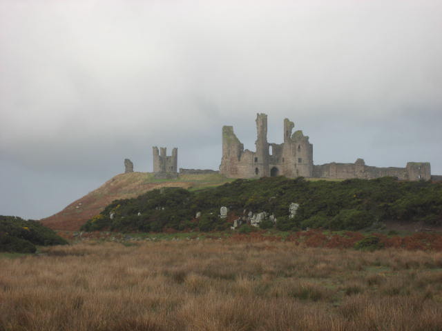
Dunstanburgh castle ruins. Built by Thomas Duke of Lancaster in the 14th century.
The footpath here is the Northumberland Coastal Path and St. Oswald's Way. We walked past the castle, not bothering to read the noticeboard at the entrance again and continued on our way past golf club, anticline and WW2 bunker.
Famous anticline, looking grey rather than black on this Friday. Looks like a couple of geologists on the top.

WW2 bunker.
We left the official footpath and walked down onto the beach of Embleton Bay, a long curve of sand.. A couple of weeks ago, on holiday in Spain I told a lady where I lived. She said we had miles of lovely beaches but not an awful lot of facilities. What does she want? Hotels, sun loungers, bars?
Embleton Bay on a grey day, temperature about 6C
At the north end of the bay is Low Newton by the Sea, a square of cottages with a well known pub, the Ship, which has its own micro brewery and is renowned for its food. We walked behind the square to the Newton Pond Nature Reserve which has a new hide.
Low Newton, cottages and pub

New hide at the nature reserve. Not much on the pond, ducks and a lone redshank.
Leaving the hide we followed the footpath through the summer shacks that overlook the beach and walked round the edge of Dunstanburgh Castle Golf Course to Dunstan Steads, a tiny settlement. From here we walked along a concrete strip on the edge of fields to the farm and cottages at Dunstan Square, passing a limekiln and unusual WW2 bunker.
Limekiln (used for making a fertiliser in the old days)

It looks as if it was made from concrete filled sand bags. We thought of using it as a Herbie Spot but it was low and dark.
Instead we walked on to the village of Dunstan and made use of the bus shelter.
The bus shelter mad a good Herbie Spot. I had soup and we shared granola cookies, Nature Valley Crunchie biscuits and savoury muffins from Mrs A..
Lunch over we took the road past Craster Tower and turned right up a lane to Craster South Farm. From here the route crosses several fields to the carpark at Howick Hall and then down the road to the farm named Sea Houses, appropriate name considering its situation. We took the footpath down towards the sea, turned left and followed the coastal path back to Craster.
This cottage was built as a bathing house for the ladies of Howick Hall which is the home of  the gentleman who invented Earl Grey tea, introduced the 1833 Great Reform Act and has a statue on top of a monument in Newcastle.
Changed we headed for the Cook and Barker at Newton on the Moor. On offer were three hand pulled beers; Alnwick Blonde. Stygian Blonde and Black Sheep. And I wasn't driving!


Both maps; Contain OS data, copyright. Crown copyright and database right 2018.


A min matrix:
                                                                        steps                      miles
NAK                                                               32053                     11.63


iPhone                                                             26209                     11.9
OUTDOOR GPS                                                                            11.8
Brian                                                                                                11.93


Thursday 22 November 2018

A short walk on a wet Thursday round part of Wallington Estate. (Northumberland) Nov 22nd.
  The weatherperson said it would be a cold day but mainly dry. How wrong the weather person was, it rained nearly all day.
Dave and I decided to have an extra little walk this week, one round part of the Wallington estate in Northumberland. Wallington Hall was the home of the Trevelyans and is now a National Trust property and we went nowhere near the hall itself anyway.
Getting to the start is more complicated than describing the walk. We left Newcastle and took the road through Ponteland and on to Belsay. Just beyond Belsay is a three way junction, we took the road to Bolam Lake and drove past the pond on the west side to Scots Gap. We turned right at Scots Gap and headed north. About a mile past Rothley Cross Roads a narrow single track badly maintained minor road took us to an off road car park (gated but free) near Wideopen Cottage.
This walk is probably the best signposted walk in the UK and is easily followed without a map but should you need one use OS OL 42 Kielder Water and Forest. The car park is at GR NZ034915.


A grey day, we were the only ones in the free but gated car park.


Clear signing from the start.
Leaving the car after the rain had eased a little we heade just west of north on a clearly marked path that went alongside an old quarry.
Turning left into a field we obediently followed the trail on the perimeter, turning right at a plantation.
Just one of the many highly visible yellow capped posts on the walk.
About half way along the forest fence we took a path through the wood, continued on the edge of a field and then on the path just inside the coniferous plantation.
Some way into the woodland the track headed north across moorland. An excellent track, built slightly higher than the surrounding scrub and stone lined in places. Approaching the Fallowlees burn there was some evidence of ancient boundary walls and ditches, possibly iron age. The path, still well signed turned east and we approached the Fontburn Reservoir.
Well constructed stile, easily crossed

Approaching the reservoir we joined the waterside trail, possibly it circumnavigates the lake where this a nature reserve too.
For some distance the footpath is outside the reservoir boundary but at some point walkers cross into the woodland that surrounds the water. After a while the Greenleighton Walk leaves the reservoir and heads south across boggy moorland. We made a slight detour to take some shelter in a wood where we could have a brief Herbie. Soup, very warming on a cold wet day, Mr Kipling chocolate and Nature Valley crunchie biscuits.
Back on the path we walked past several Shake Holes (look them up for an explanation of their formation) and  arrived at a trig point
Dave admires the trig point (pre satellites they were used for mapping)
From the trig point we walked across a field close to the quarry and finally next to the same quarry before reaching the car.
A short walk but interesting and it has the possibilities of expansion, particularly on a dry day.
Marks of the explosives used on the quarry


Contains OS data, copyright. Crown copyright and database right 2018.
And a matrix                                            


                                           steps                                  miles
NAK                                  15053                                5.46
iPhone                               14049                                 5.6
Dave's NAK 2                   12321                                 5.63
""USB                               12360                                 5.65
""" NAK1                         12331                                  5.64
SM                                    13078                                 5.78
OUTDOOR GPS                                                         5.39


Saturday 17 November 2018

Back on the tracks (Durham) November 16th
After a warm week on the Spanish Mediterranean coast with the gadgette I am back out with a small group of gadgies to enjoy a forest walk devised by Dave and centred on the Beamish Museum near Stanley in County Durham. There is a small team, consisting of John Ha., Brian, Dave and me, starting from the car park and picnic site just outside the museum. To get there from Newcastle, A1 south, turn off at Chester le Street and follow signs for Stanley and Beamish Museum. Just before the massive entrance turn left into a Yorkshire style car park.
The map that covers the walk is OS Explorer 308 Durham and Sunderland and it's advisable.


Car park and Museum entrance. Beamish is well worth spending a whole day in. It has a town, trams, buses, a mine a farm and a fish and chip shop. And a school with sums in old UK money such as £12;7s 6d x 8 (Ans;£139) and that's an easy one.
The walk makes use of  the trails made from disused and dismantled railways and the Great North Forest Trail, sometimes marked as Heritage trail.
We left the car park along a trail in the north west corner, following three ladies on horseback, they were soon far ahead. The path, part of the Consett and Sunderland Railway Path goes west through Hellhole Wood before turning north through Carrickshill Wood, across a minor road, over a field to the Causey Road. We walked along the road a short distance  to the entrance to East Tanfield Station.
Easy to spot, the sign at East Tanfield Station.


Much of the walk is through woodland.

There are hundreds of these silhouettes around the country to mark the hundred years since the end of World War 1
Past the station the footpath wanders through the woods above the Causey Gill until it reaches Causey Arch.
Causey Arch is the oldest railway bridge in the world. It was built in 1725, one hundred years before the Stockton and  Darlington Railway. It was part of a line built to carry coal to the Tyne and was either horse or gravity powered, depending which way you went. It was renovated in the 1960s.

Coal wagons like this were used on the track.
We walked on to the Causey Arch tea rooms, turned left down a road and at the bottom of a hilltook the footpath around a field, over more field and down a short lane to the Tyneside Railway Museum which had a picnic table, so we called a Herbie.
Picnic spot; Galaxy chocolate cake, ginger cookies, mince pies and savoury muffins from Mrs. A

Workshop area of the museum. Closed for winter.
After lunch we crossed the road and  walked east along a lane towards Birkhead Cottages, turning south at a difficult to spot footpath. A field or so later we crossed Hedley Lane got lost. We were off the Great North Forest Trail in a lightly wooded area with several footpaths. Evbentually we found the track to take us to Hedley Hall Farm, more of a settlement than a farm with several cottages and barn conversions. The footpath goes through the farmyard, across rough ground where we saw a deer, and enters Mill Wood. Turning left on a lane then right to follow the footpath just inside the wood on Beamish East Moor, following the Tyne Wear Trail.
At the end of the wood we came to a road, turned right and walked past the cottages at High Forge.
Just beyond the forge, on the left the walk through Ousbrough Wood is sign posted. Another easy stretch of woodland until we came to a steep stepped path down to a footbridge.
Not sure because I can't see a name on the map but this footbridge crosses the Team Valley stream
Having walked down the steep bank we were rewarded with a steep climb through the woods, not on the Forest trail, but a footpath that brought us to a road  and the pub, The Shepherd and Shepherdess, very close to the museum entrance and the car park. Having changed from very muddy boots we went to the pub, surprise.
The pub near the museum. Warm and welcoming and with three ales on hand pumps, Timothy Taylor's Landlord, Wainwright and one made for the pub. The soda and lime was good too, as was the tea said John.

Contains OS data, copyright. Crown copyright and databaseright 2018


Matrix MMXVIII 11a
                                                                     steps                             miles
NAK                                                           25463                              9.24
Etrex                                                                                                   9.11
iPhone                                                                                                 9.5
Dave's NAK2                                             20149                              9.22
"""""USB                                                    20397                             9.33
"""""NAK1                                                 20144                              9.21
""""  SM                                                      20537                             9.08

More pictures on a gloomy slightly foggy day