Translate

Friday 29 December 2017

Ferry across the Tyne  (Two of us wearing raincoats)... December 29th
  Should you be wondering why there was no walk reported last week it is because only two of us, Harry and I, yturned out. We walked down Jesmond Dene, through Ouseburn and along the Tyne quayside to the Quayside pub (for coffee) and then up through the streets of Newcastle and home. This pleasant walk through a park and reclaimed industrial area has been covered before, the last time being "Gese Muth" on October 14th 2016
  Today, the two of us again, are walking from seaburn north of Sunderland, taking the ferry across the Tyne from South to North Shields and then walking on to Whitley Bay. No map needed really but it is covered, apart from the very first few hundred yards  on OS Explorer 316, Newcastle upon Tyne.
We met at the metro station on the Haymarket, Newcastle and took the first train to Seaburn. It was, as promised by the weather girl on the local TV station, snowing, we were earing waterproofs.
An out of focus photo of Seaburn metro station instead of a car park.
From the station we walked down the street in an easterly direction until we hit the sea where we turned north and headed for South Shields.
Not far up the coast we came to Whitburn, in summer a lively little place but very quiet on a wintry day in December so we continued on our way.

Interesting plaque in Seaburn, one of the first in what became the RAF.
                          Wet Whitburn. The claim to fame of the hotel in the background is that Lowery stayed there to get away from the stick people of Manchester factories.


Further up the coast, which is a haven for seabirds but most seemed to have taken shelter today, apart from a kestrel we watched hovering near the edge of a cliff, we came to Souter Lighthouse, a national trust property.
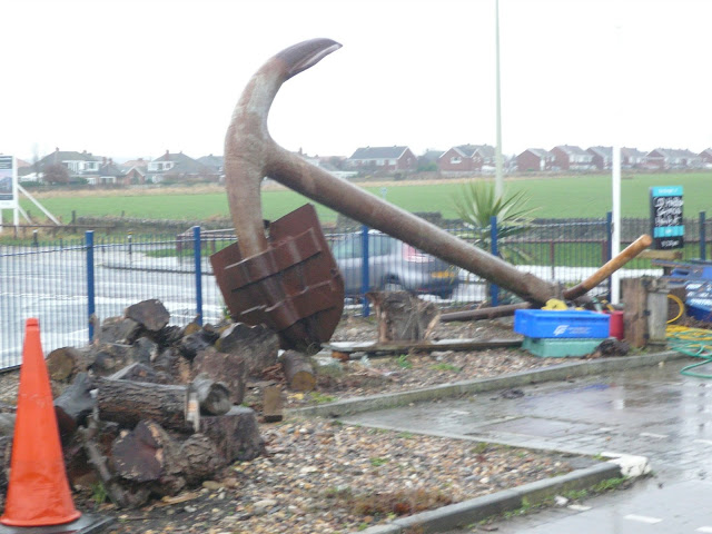
                  Anchors away, near Whitburn
                      The Ring of Whitburn, an enchanted maze close to the sea.
                                      Souter lighthouse, and foghorn.
Next pause was at Marsden Bay, famous for its grotto and lift
                            Entrance the famous Marsden Grotto, with snowflakes
Very soon we hit the outer limits of South Shields, sticking to the coastal path, passing the part of the town where the Great North half marathon is run. By now it had stopped snowing so we took off our waterproofs to enjoy what promised to be a scorcher by mid afternoon.
One of the delights of South Shields is Ocean Road, a continuous row of curry houses and restaurants, mostly serving Asian dishes but several offering that great British take away....
What did the Romans do for us? Arbeia was a supply fort for Hadrian's Wall, holding large grain supplies and many legionnaires. Well worth a visit, so is the fish and chip shop.
Near the market we stopped and had a bacon sandwich and tea. Harking back to the days when we awarded flitches for sandwiches, I gave this one five. Tasty bacon, fresh brown bun and brown sauce, lovely staff, great service and the tea was hot and strong.
Break over we walked down to the Ferry Terminal and crossed the river to North Shields. Many years ago, before the river was dredged, it was possible to walk across the river at low tide, hence the expression  "All together like the folks of Shields" 
Far too deep since the mid 19th century for such pleasures foot passengers now rely on the ferry although further upstream there is a pedestrian tunnel under the Tyne.

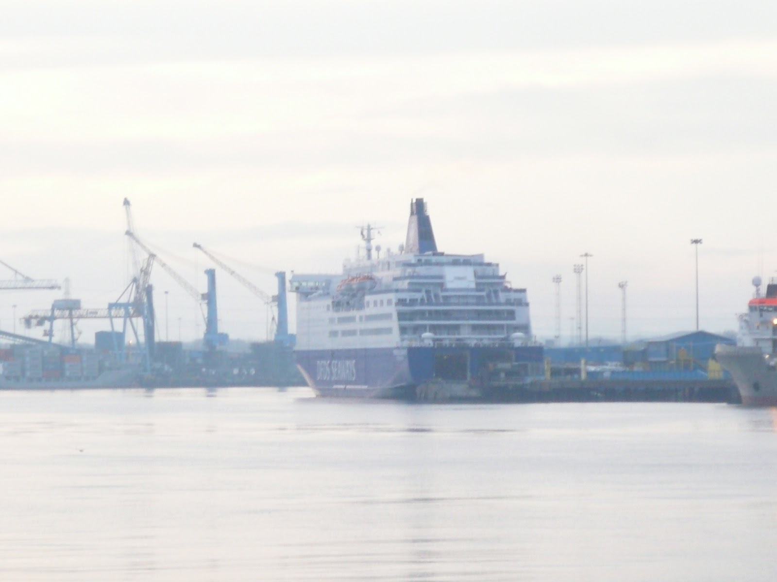
                The Tyne to Ijmuden ferry (Holland) It takes about 16 hours to cross the North Sea.
From the ferry landing we walked along the river side, passing several tempting fish and chip shops with some difficulty.
          This memorial to all fishermen lost at sea was erected earlier this year on the promenade that leads to Tynemouth. Made from metal, a beautiful piece of work.
Along the promenade we passed below the statue of Admiral Lord Collingwood, second in command at Trafalgar, first in command when Nelson died, pupil at Newcastle Royal Grammar School and sometime inhabitant of the hall at Hethpool near Wooler.
Collingwood, still looking out to sea.
Next monument along the way is the ruins of the Benedictine Abbey at Tynemouth, and next to it the ruins of one of several castles constructed on the orders of Edward I to keep the Scots at bay.

                             Abbey and Castle.
Continuing north we walked through the village of Cullercoats, famous for fishwives, and finally reached Whitley Bay, tired holiday resort trying hard to revive itself.
Here we parted company, Harry catching his bus home and me catching mine.
No pedometer readings today but my iPhone recorded a walk of about 13.3 miles. Not bad for a wintry day, no hills, not much wind, but most enjoyable.
This is the last walk of 2017 so thanks to all those readers who have looked at our blog and see you next year. Hope you all have a happy one.

Contains OS data. Copyright. Crown copyright and data base right 2017

Saturday 16 December 2017

Belsay, Bitchfield and Milbourne. (Northumberland) Dec 15th.
 Sounds like another trio of solicitors but they are three places on today's walk, which again is a local one.
Starting at Belsay, the Blacksmith's café near Belsay Hall along the road from Ponteland, three of us are out to enjoy a country stroll on a cold, probably wet, December day. The mini team is Harry, John Ha and me.
The map to use is OS Explorer 316 Newcastle upon Tyne and the café is at GR NZ101785

Although we are not visiting it Belsay Hall is worth a mention. The original castle, built in the 14th century was inhabited by the Middleton family until Charles Monck (real name Middleton too but he changed it to Monck to get an inheritance, who wouldn't) designed and had built the new Belsay Hall between 1807 and 1817. He supposedly designed it on honeymoon in Europe, as you do on honeymoon, design houses. It is now an empty shell, owned by English Heritage but nevertheless it is well worth a visit, along with the castle, the beautiful gardens, formal and informal, the tea shop and of course the gift shop.
           Belsay Hall, supposedly the first stately home in England built in this, Doric style
                       Belsay Castle and the old hall.

WARNING: THIS CAN BE A MUDDY WALK.
  After coffee in the Blacksmith's, a cosy café which offers top ups and sells some local farm produce, we booted up in the car park and began the walk. A new walk, devised by Harry, mostly flat and across farmland. We made a couple of errors and a couple of route changing decisions so on the map I have marked the route we took in a continuous line and the plan in a broken line.
                           Blacksmith's café. We parked round the back.
 No sooner had the three of us headed south along the track to East Beechfield farm than the heavens opened. Expecting rain we were already in waterproofs but still stopped to add covers to rucksacks. And it only rained for a half hour. At the farm we failed to spot the footpath marker and walked round the edges of a couple of fields until we hit the path, left it again and crossed fields to West Newham farm, thus missing out on West Bitchfield which has a great name and a Peel Tower.
                                    West Newham?
The road from the farm is familiar, we have cycled it on many occasion heading for Stamfordham. We opted to follow the road rather than take the footpath across fields. At the end of the farm road we turned left, still on a public highway until we reached the track on our left which took us to Huntlaw, a settlement of pretty cottages and nothing else.
Beyond the cottages we followed a good track north to Newham plantation, then east and south across fields before getting back on the footpath.
At this point we called a Herbie Spot; a poor one I am afraid, mince pies and cookies. Nothing wrong with them, just a lack of goodies!
Herbie time over we walked across fields West Grange and then on to to Milbourne, another pretty little Northumbrian village, complete with church and brick built Wesleyan Chapel. Missing the path again we walked along the road until we found a signpost directing us north to East Newham farm. The footpath crosses a field  planted with turnips but the farmer, wisely and helpfully, has marked out the path across the crop, using an occasional plastic post.

The rusting remains of a wind powered well  East Newham.
At this farm we headed west along the road to Middle Newham Farm and the site of a Medieval Village, not much to see of that but mounds outlining houses. Here we took a footpath across the muddy fields  to East Beechfield, first farm on our journey and then back down the track to the Blacksmith's at Belsay.
Changed, we were about to set off for the Blackbird at Ponteland when Brian appeared. For his own reasons he had started the walk well after us, had gone the opposite way too but we had never crossed paths. I am guessing he kept to the real route and we passed, like ships in the night on the dotted bit near Huntlaw, marked Stony Hill on the map.
The Blackbird had several ales on offer, I chose The Blackbird IPA, very refreshing too.
A grand walk for a winter's day, one to be kept and extended for the future. Thanks Harry. Not having Dave and his four pedometers with us today the matrix is greatly reduced:

                                                                         steps                                     miles
NAK                                                                22750                                    9.33
IPhone                                                             18017                                    8.7
OUTDOOR GPS                                                                                           8.4
Brian                                                                                                              8.25


Friday 8 December 2017

Hartley, Holywell and the Sluice. (But it is a new walk)(Northumberland) December 8th.
   The forecast is for a cold day, wind chill factor sending us out in
temperatures below zero, so we are staying close to home and enjoying, hopefully, a new walk.
Staring at the Delaval Arms at Hartley, south of Seaton Sluice on the road to Whitley Bay, five of us are on a rectangular walk. Visits and colds have reduced numbers,( the Norton Anti Virus is not working according to Brian) The map to use is OS Explorer 316 Newcastle upon Tyne and the Delaval Arms pub is at GR NZ341758. Down the road towards the sea is a  car park for the one who used a vehicle, most of us came by bus.
                               This week's sun kissed freezing car park.
The walk;
From the car park we went through a gate and followed the footpath across grassy land, part nature reserve, to the road that goes to St. Mary's Lighthouse. The island is only accessible when the tide is out, as it was today, but we didn't cross the causeway. The island has, apart from the lighthouse, a nature reserve, with seals if you are lucky.
                            St. Mary's lighthouse.
After a short walk along the road from the lighthouse we crossed the main Blyth Whitley Bay road and walked up the side of the cemetery and continued to a dismantled railway, easily recognisable because the bridge abutments are still there.
                                      Turn left through the "bridge"
From this point we followed the footpath across fields to Dene Farm where we changed direction and walked northwest to Crow Hall Farm.
From this farm we took the lane almost into Holywell. On the edge of the village we turned right and in a corner between houses found the path for Holywell Pond. At the pond there is a bird hide, beautifully decorated by Year 3 children from the local school. Unfortunately there are no windows in the hide, just open viewing points facing north and the cold wind came right through. Being tough gadgies we declared a Herbie Spot. Not being a large turn out there were slim pickings today, Alpen bars, Yorkshire flapjacks and mince pies for Christmas.
                Holywell Pond, quiet today, all the birds trying to keep warm.
Lunch over we continued down the side of the pond and turned north west when we reached the dismantled railway, now a footpath/cycle path with no evidence of the days of steam, or diesel.
At The Avenue, the road from Seaton Delaval to Seaton Sluice we turned right then left along the road to New Hartley.
There is a memorial garden in the village to the 204 men and boys who were killed in the Hester Pit disaster of 1862. The cast iron beam of the pumping engine broke, fell down the shaft and trapped the men. There is also a memorial to those killed in Earsdon Church Cemetery where most of the victims were buried. After this disaster the government passed legislation ensuring all pits had two  shafts.
Back on the footpath we walked past Seaton Red House Farm and on to Lysdon Farm. Here we followed a path, that had no arrows, across fields to Gloucester Lodge Farm on the coast south of Blyth. It gets its name from Napoleonic times when the Gloucester Regiment were camped here, well out of the way.

Gloucester Lodge Farm.
Here we joined the Eve Black path that crosses the dunes from Blyth to Seaton Sluice. Years and years ago the area round Seaton Sluice was a busy little town with coal exports, glassworks and a remarkable sluice that scoured the river. There is also a cut through high rocks allowing ships to enter the harbour at all times. Some evidence of the sluice remains and the cut is there but the small harbour is now a haven for small boats.                                                                                             
Seaton Sluice. The cut in the centre distance.
From here we walked up the road and along a path back to the car park. And then to The Delaval Arms which had several real ales on draught, including Wainright named for the great Lake District Hill walker.     And Brian joined us, he had started the walk later.                                                                                                                                     
 The Blue Stone outside the Delaval Arms. Thought to be a Saxon boundary marker. In the latter half of the n18th century strong man Willie Carr of Hartley and Blyth, could pick it up as a demonstration of his strength.
The Delaval Arms, good beer and friendly staff.
Contains OS data. Crown copyright and database right 2017


The Matrix MMXVII almost the last
                                                                             steps                            miles

NAK                                                                   24833                                10.19
iPhone                                                                 20660                                9.7
Dave's 3D                                                           20400                                9.99
  "" USB                                                              19923                                10.06
  ""  NAK                                                             19890                               10.84
Sylvia's mother                                                    20757                                10.58