Translate

Saturday 29 January 2022

Eight go searching for St. Cuthbert. (Again)

 Eight go searching for St. Cuthbert  again.

(Northumberland) January 24th.

 I couldn't join the boys (and girl) last Friday for the walk from Warkworth as I had had a rather painful injection in my arthritic knee and had been told to lay off any form of exercise for a few days. But I am back today with a team of eight following a familiar path from Belford in Northumberland.

We are: me, Dave, Harry, Brian, Margaret, Ian, John H and John L.

The walk starts from the village of Belford which is easy to find. Head north on the A1 and turn left for Belford somewhere north of Alnwick. There is a group of grain silos on the right, look out for them.

A map is not essential but the walk is covered by OS Explorer 340, Holy Island and Bamburgh. Breakfast at Sunny Hills farm shop at the start of the village.

Breakfast over we went up the main street, turned left on the Wooler road and parked in front of the old community hall. Off road and free.


No prize for a car park but convenient for the walk. A bench for booting up too.

We followed the lane on the left side of the hall, passing the crenelated  farm house at Westhall and going through the farm yard itself. The path crosses fields below Chapel Crags and Sunnyside Crag, passing Craggyhall and a lime kiln too.

                      Crenelated farm house................ 
                                ..................... rucksack and limekiln. Could be a good name for a pub.
Beyond the fields the path enters Square Wood which isn't. At the first junction we took the track to the left and soon came to Swinhoe Farm (mile 2).. At the farm there is a cross roads, we turned right  and walked on to Swinhoe Lakes.

                   Swinhoe Lake, very quiet today.
Beyond the lake, the track climbs slowly up through the interestingly named Virgin Hill Wood. However our way was blocked by several trees that had fallen across the path and we had to go into the adjacent field to get round them. (Scrambling over days are gone)

                Just some of the many trees blown over by storm Arwen some weeks ago.
Back on track we crossed a field to what I think the French call a Carrefour or supermarket, where four trails meet. There is a great view from here over the north sea and Holy Island. (Mile 3 plus)
                 The causeway to Holy Island

                   and a bad picture of the castle there
 We took the track heading north west, passing the new anglers refuge on a small lake.
                  Anglers rest, nobody around today.
 
The track goes through woodland towards Raven's Crag before turning south (mile 5) round Copsey Hill.
The path off the track is not marked but is on the left at a point overlooking Holborn Farm.

Turn left at this point for the footpath over Greensheen Hill'
From here we followed the footpath  round the south side of Holborn Lake and along the ridge of Greensheen Hill.
                             Holborn Lake, quiet too
                                                      Trig point and hazy Cheviot.(mile6)

The footpath crosses a wall and then joins St. Cuthbert's Way to head steeply down to the saint's very own cave. People are currently requested not to enter as some damage has been done but we declared a Herbie and settle down for lunch.
                    Some of the team lunching: biscuits, apple and blackberry pies,flapjacks, savoury and sweet from Mrs A and almond slices from Mr Kipling.


                 St. Cuthbert's cave. As a reminder the saint was a monk and a bishop, living from 634 to 687 AD, spending some time on Holy Island and befriending otters.. On his death his corpse was carried around before he was finally settled in what became Durham Cathedral where he remains. According to on line Brittanica the cathedral was destroyed during Henry VIII's reformation. I can assure you that the magnificent Norman Gothic pile was intact and in working order a few weeks ago when I passed it.
Lunch over we joined the track at the foot of the hill and headed south east, passing the rocks at Cockenheugh, more impressive than St. C's but not as well known. (mile 7)

                                        Cockenheugh
Beyond the outcrop we followed the track which has recently been improved for forestry work until we were back at Swinhoe Farm.


                                            The cows of Swinhoe Farm.
At the farm we took the path trough the yard, past the riding school and onto the Northumberland Coast Path/ St. Cuthbert's Way. Crossing fields on an almost straight path heading south east we were soon back at the cars. Changed we headed for the Ridley Arms at Stannington which was serving Consett Pale Ale and Farne Island, along with tea or coffee.

                       Contains OS data, copyright. Crown copyright and database right 2022
The walk is just over 10 miles, mostly flat with some gentle climbs and some splendid views.

                      And a few words from Brian (Vera is a north east TV detective)
And a couple of photographs


Saturday 15 January 2022

 On the road again.  Mostly St. Oswald's (Northumberland) January 14th

Last Friday the boys started the year with the traditional walk from Blyth, along the coast to North Shields. I was unable to join them, being isolated  with covid. But today I am unchained having served my 10 days and, along with several of the others, off for a walk based on Felton, a village in Northumberland.

Easy to find, head north on the A1 and turn off at the signpost for Felton. There is parking in the village and also an excellent cafe, the Running Fox. Sadly it was fully booked so some of us went to its sister cafe at Shilbottle.

A team of six: John H., John C., Margaret, Brian, Dave and me. And a perfect day for a winter walk, blue skies, no wind and a temperature of about 6C. Fleeces came off after the first mile!

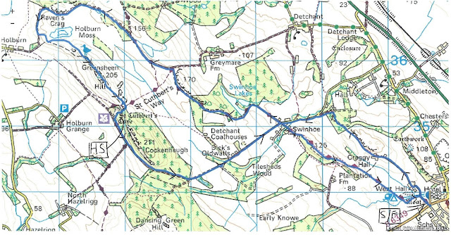
Maps: OS Explorer 325, Morpeth and Blyth; OS Explorer 332 Alnwick and Amble.

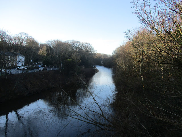
Felton is on the north side of the River Coquet, on the south side sits West Thirston. The two are joined by a 15th century bridge, now used by pedestrians, and a 2oth century concrete span. The parish church, St. Michael has roots in the 12th century, with lots of later additions and extensions. The name Felton comes from Old English "Feld tun", meaning field farm.

There didn't seem to be a car park so we left cars on the street outside the Running Fox cafe.

Parking in Felton, in front of the Running Fox, a cafe well worth visiting, but book first, always busy.
And finally the walk:
 Walking away from the river, passing the cafe, we went uphill for a short distance before turning off on the right and going down Mouldshaugh Lane, tarmac and easy going.
 Should have moved the twig. It says "No grown ups allowed", so we walked on.
Soon we reached the farm at Mouldshaugh where Dave and I initially mistook the sound of some farming or DIY implement for a woodpecker.
                     Mouldsclough dovecote
At the farm  (1 mile)we followed the signpost's direction across a field and entered a wood above the River Coquet, a bit on the muddy side but a lovely walk for about a mile before we left the river side (2 miles), crossed fields and re-entered woodland. Staying close to the river we passed some areas of interest to industrial archaeologists; remains of iron works and water mills. Close to a horse shoe shaped weir we came across the memorial to soldiers who had died in a tragic accident in 1945. Young trainees, fully equipped, their boats capsized.


 Memorial near the weir. (DLI is the Durham Light Infantry, DWR is the Duke of Wellington's Regiment)
Just beyond the memorial we joined the road going downhill, turned right and crossed the river (3 miles)
On the north bank are the remains of a chapel.
                                                 The weir where the accident happened.

                                  River Coquet.
We stayed on the road, shortly after passing Acklington Park we took the footpath on the left, across a field to Morwick Banks, another muddy, woodland footpath above the river. Leaving the wood (mile 4)  we crossed fields, crossed the main east coast railway line very carefully and headed for Morwick House (5 miles). Morwick house has an ice cream shop/ cafe, unfortunately closed today but we made use of the picnic tables for a Herbie.
 A lady came out of the building, said it was fine to eat there but would we please take our rubbish away with us as the bins had been taken indoors for winter. As one we chorused we were all well brought up and of course would not leave a scrap. ( I left my apple core for the birds).
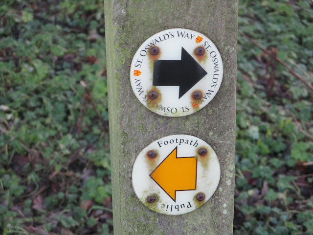
                  Apple pies, cookies, almond slices, savoury buns and cake from Mrs A
                  Worth calling in for the ice cream when open.
We headed south for a short distance before joining St. Oswald's way and turned east along Rake Lane.
Going under the east coast railway line  (6+ miles) we followed the green and muddy lane to Low Park and onward to North/ South Park Wood (8 miles) Once through the woods we walked on a road downhill before joining the riverside path again. At this point St. Oswald's Way is in open fields which are though to have been the site of a Viking camp. (9 miles) Eventually we reached West Thirston. The footpath had been damaged by flood or storm Arwen or both and we had to take a diversion before heading down towards the bridge in Felton again. (10 miles)
Having scraped off some of the mud and changed we went to the Northumberland Arms in West Thirston. Lovely pub, friendly staff and Rigg and Furrow or Tyneside Blonde ales were on offer.

Contains OS data, copyright. Crown copyright and database right 2022.
The walk is 10 miles, easy going with only a few gentle slopes.

                         The old bridge at Felton. it once carried the main Great North Road.