Ambulare in Hadriani Vallum. (Northumberland)
September 25th.
Haltwhistle claims to be the centre of Great Britain. A small town on the South Tyne its name comes from Old English Hautwisel meaning the place where two rivers meet near a hill.
Today five of us are repeating a walk last done in March 2016 starting from the centre of the town. Today's team is Brian, Margaret, John H., Dave and me.
To get to the start A69 west, turn off at the sign for Haltwhistle, turn right at the fork in the road (not the road to Hadrian's Wall) and park off the street above the Sainsbury's supermarket. Some of us had breakfast in the Pillar Box on the main street. Some were stuck in traffic.
Haltwhistle claims to be the geographical centre of Great BritainOnce it had a mining industry
Parking. Not a patch on the superb photograph of the car park in Craster published last week. Not £4 either.
Across the road from the car parking a brown sign points the way up Willia Street to the Burn Gorge. We followed it and were soon in the Haltwhistle Burn Gorge. There are paths on either side of the burn, we took the east side passing the sites of long gone mining. The path follows the stream steadily upwards along a pleasant wooded track, passing a lime kiln and eventually emerging into a field.
The path in Haltwhistle BurnBehind the trees there is a lime kiln. (Another one!)
We crossed the field and were on the B6318, usually referred to as the military road. After a couple of hundred yards we followed the sign post down a narrow path and into a field. Much to Dave's delight the outlines of several Roman camps and a fort are in the area. Not much to see, just grassy banks in the typical playing card form of Roman military sites. having crossed the field we also crossed a minor road and walked up to Hadrian's Wall, arriving at milecastle 42. There were quite a few people wandering the wall, taking notes, taking photographs and being delighted at the beauty of Northumberland.
Approaching Milecastle 42, the answer to everything. As the name suggests there is one every Roman Mile, numbered from east to west.
Some years ago the information boards were either missing or in poor shape. They have ben replaced and improved too.
(You might prefer to follow the minor road to Cawfields where there is an informationcentre and picnic areas. Then you can walk the wall)
We followed the wall path for several miles. Easy to follow, keep the wall on your left if walking east. Great names along the way: Dorny Doors, Caw Gap, Bogle Hole and Green Stack. Plus the sites of several turrets and Milecastle 41, not much to see there.
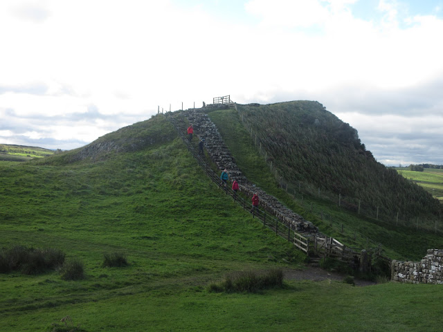
The wall follows the line of the Whin Sill, a rocky outcrop that crosses the county, and there are several short but steep ups and downs to be suffered. Some have steps in the slopes, some don't. And as promised, it was a very windy day, a strong blast coming from the north across the wall.
Information board and remains of turret 41a. There are two turrets between each mile castle, named a and b and the number of the castle.
Windshields has a trig point too. (Not Roman)
As we approached the parking area at Steel Rigg we cut across a field and joined the road down to the pub at Twice Brewed and the Sill, fairly new information centre and Youth Hostel. There are picnic tables at the centre so we called a Herbie.
This is my favourite view on the wall. Highshield Crags and Crag Lough. The wall runs along the top of the crags.Back end of the Sill Information Centre and Gift Shop.
We shared brownies, carrot cake, bramley apple pies, mince pies and savoury cake from Mrs A. Surprisingly I am losing weight.
The Sill. You can walk up to and on the roof.
A willow deer.
The Sill. You can walk up to and on the roof.
A willow deer.
After the Herbie we headed west past the Twice Brewed pub and after a short distance followed the sign post on the left to Seatsides, which is on the course of the old Roman Road, the Stanegate, a sort of service road for the wall and its forts. Heading west from here we crossed fields full of Alder grass, that clumpy stuff some time called Dougalls, which makes walking uncomfortable. having stumbled across a couple of fields we came to a minor road and turned right towards Hill Top Farm.
There were several of these hardy looking horses in the field we crossed at Hill TopJust beyond the sign in the photo above we turned left through a gate and followed a grassy track in a curve to High Plantation. The path here is a bit tricky to find, it's through a gate on the left and is not too obvious. But once found we crossed fields to Hollincrag and down a track to Oakey Know, passing the magic tree on the way.
Magic mushrooms at the foot of the magic tree The magic tree. It used to have lots more branches but many have been blown off
Not far from the tree we found ourselves back on the A69 and walked back to the cars in Haltwhistle.
Changed we headed for the Twice Brewed pub for liquid refreshment. The pub has its own brewery and strict controls at the moment because of...................
The walk is about 10 miles of lovely northern scenery.
The Twice Brewed


No comments:
Post a Comment