Swallows, Stonefolds and Sooks. (And they come in threes)(Northumberland) July 14th.
Reduced to four by holidays and family commitments, Dave, Brian, John H. and I are off for a walk on and near Hadrian's Wall.
Starting from Steel Rigg car park near the new information centre at Once/Twice Brewed, the walk heads east, turns north, then west and back to the car park.
From Newcastle, take the A69 west then the B6318 known locally as the military road, turn right up the lane at Once Brewed and the car park is just north of the wall itself.
The map to use is OS OL 43 Hadrians Wall and the car park is at NY751676 approx. (It also has lockers for bikes)
Breakfast was at Brockbushes garden centre/café/pick your own/farm shop on the roundabout for Corbridge. Tea/coffee/latte(?)/bacon sandwich and they have an old tractor like my uncle Clifford had.
 a proper tractor
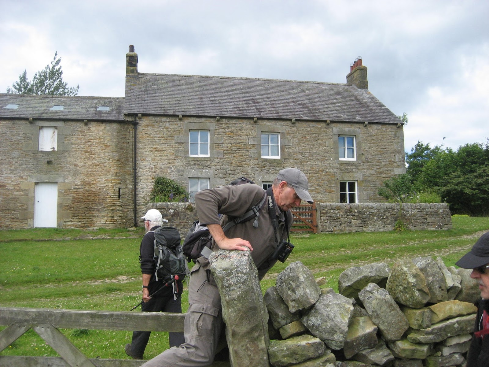
Steel Rigg car park charges £4 for a day, which is reasonable. But the machine was broken so we joined other parkers by leaving notes attached to windscreens explaining we would love to have paid but malfunction prevented us. There were cars from several European countries making the most of open access before Brexit.
 Steel Rigg car park.
From the car park we walked down to the wall.* This section is a "Clayton Wall", the land was bought in the 19th century by Mr Clayton who rebuilt some sections of the northern boundary of the empire, some 1400 years after the Romans went home.
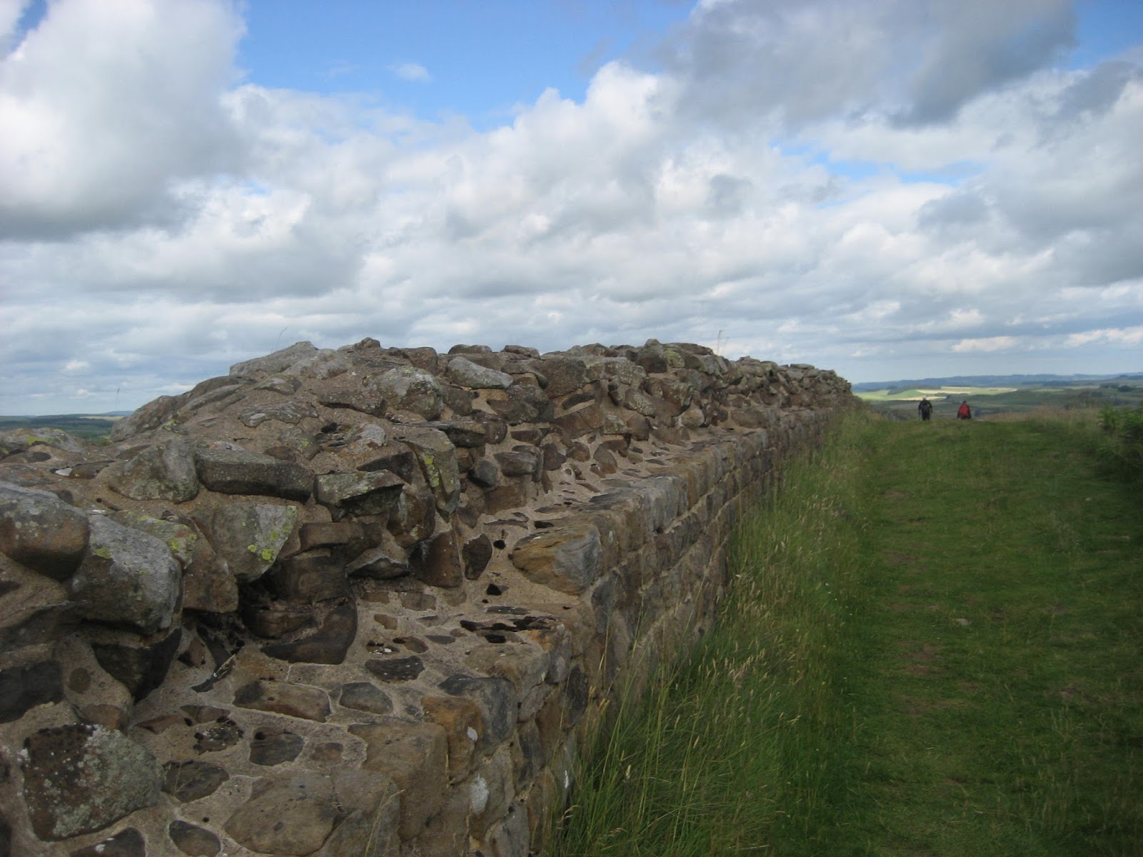
The first two miles of the walk, along the wall, have several very steep but short ascents and descents, the first one right at the start.
 Looking down from Peel Crags on the remains of a turret. This turret is an "extra" built at a weak spot, and does not have a number. The milecastles are numbered from east to west and the two turrets between them are numbered A and B eg 39A, the next one we came to.
On one ascent we met an American, deep in conversation with an English couple, but he did say "Hi" as we past.
 Milecastle 39, with visitors. We past several school parties walking this section. Nice to see them out, and they appeared to be enjoying it. Probably got a question session back in the coach.
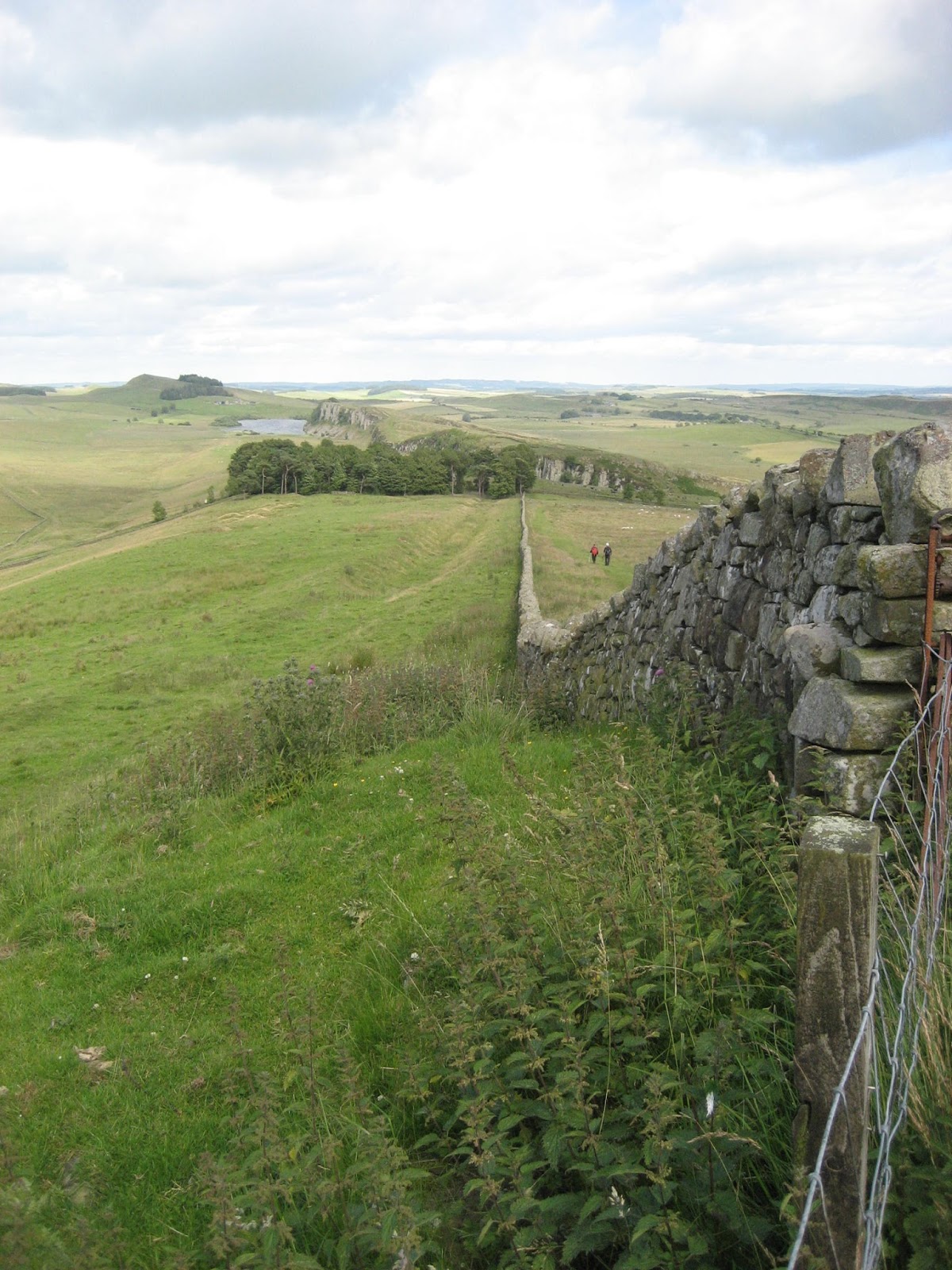
After a mile we came to Crag Lough, a small lake, the wall runs on the ridge high above it. This is my all time favourite section of the wall.
 Crag Lough from Steel Rigg
 Looking down on the Lough from the line of the wall
 The lough through the trees.
I was by this time alone, John and Brian well ahead and Dave somewhere behind, busy taking photographs. I chatted to an American lady enjoying a sandwich and the view. She explained that she was waiting for her husband who was way back, talking to somebody.
Further on on this section of the wall is "Sycamore Gap" where Kevin Costner shot a scene for Robin Hood, Prince of Thieves. Miraculously he had travelled from Dover beach to Hadrian's Wall in minutes.
 The famous Sycamore and its gap. There were an awful lot of people walking the wall today, some out for a stroll, some doing the full length. (about 80 miles) Brian observed that some were Day Trippers and some were taking The Long and Winding Road.
Just after two miles, being an honest citizen, I took the diversion established to prevent erosion close to the wall, and also to avoid the steep descent on a rocky path. I heard Dave shout, turned and watched him waving to me. Because of the diversion I had missed the style the where the Pennine Way ** crosses the wall. First mistake of the day.
Having crossed the wall I followed the footpath north east. For a major national trail this section is not of the best quality, meandering across fields. John and Brian were out of sight, somewhere ahead, I took a footpath east which actually leads to Broomlee Lough. Looking back I noticed Dave had stuck to the Pennine Way, claiming the others were ahead. I turned back to join him, second mistake of the day.
Having battled through a small herd of curious cows with their calves we caught up with the other two and called a Herbie Spot, sitting behind a wall and enjoying the views, and the lunch.
 View from the dining room. The hill on the right is Kings Crag and there are Roman inscriptions on the rocks there, supposedly. We have tried on previous occasions to find them.

This is a selfie, but taken in hope with my camera. Worked well. We shared Snickers, Scones from Mrs A., carrot cake and vegan fruit cake from www.jesmondcakecompany.com.
Lunch over we headed north across the fields, and still on the Pennine Way, to East Stonefolds farm. To get onto the farm track we had to climb over a very rickety gate. From here we followed the farm track south west to West Stonefolds farm. I had been carrying my walking poles, rifle like over my shoulder, but decided, just past the farm to use them. I noticed then that the lower section of one pole was missing. " Oh, Gosh" I exclaimed and set off back along the track to find it. I reckoned I would have caught it climbing the gate, I reckoned right too. The lengths some people go to to get in an extra half mile on a walk. This was mistake number three. It was generally agreed that Help, I need somebody to keep an eye on me.
The footpath goes along the edge of Greenlee Lough, part of which is a nature reserve and has no access. We did go into the bird hide on the north side of the lough but there wasn't much going on.
 Greenlee Lough from the bird hide. According to the notebook left in the hide the area was dripping with birds. We saw a few ducks.
Back on the footpath we were pleased to see that a duck board walk had been built across the marshy ground near the water.. When we came to the end of it we headed north west uphill to meet a farm track, turned left and walked to Gibbs Hill farm (mile 6).
There are two footpaths from the farm, starting on the right side of the track. We took the right fork and walked west to Swallow Crags. Not very high but impressive enough and there were some swallows around.
 Swallow Crags.
Near the end of the crags we found a path over them and down to Saughy Rigg farm, farm and B and B. Up the track to the road, we turned right and walked to Well House.
 Well House.
Just beyond Well House we spotted the sign post that said "Military Road 1.5 miles" and we tramped through long grass towards Windshields Crags

Windshields Crags. Part of the Whin Sill which is a tabular layer of the igneous rock dolerite. It crosses Northumberland, much of the wall is on it and at the North Sea end is the imposing Bamburgh Castle.
Once on the top of the crags we turned east and walked alongside the wall. We met an American lady, sitting enjoying the views. She said she was waiting for her husband who was way back, talking to somebody.......................
* Hadrian' s Wall. Built on the orders of Emperor Hadrian and started in 122AD. It took four years to build, has several forts along the route, milecastle every Roman mile and two turrets between each milecastle. It marks the northern limit of the Roman Empire, is about 80 miles long and is a World Heritage Site.
** Pennine Way. Longest long distance path in the UK, starting in Derbyshire and finishing in Scotland, just. About 210 miles long.
Gallery


Reduced to four by holidays and family commitments, Dave, Brian, John H. and I are off for a walk on and near Hadrian's Wall.
Starting from Steel Rigg car park near the new information centre at Once/Twice Brewed, the walk heads east, turns north, then west and back to the car park.
From Newcastle, take the A69 west then the B6318 known locally as the military road, turn right up the lane at Once Brewed and the car park is just north of the wall itself.
The map to use is OS OL 43 Hadrians Wall and the car park is at NY751676 approx. (It also has lockers for bikes)
Breakfast was at Brockbushes garden centre/café/pick your own/farm shop on the roundabout for Corbridge. Tea/coffee/latte(?)/bacon sandwich and they have an old tractor like my uncle Clifford had.

Steel Rigg car park charges £4 for a day, which is reasonable. But the machine was broken so we joined other parkers by leaving notes attached to windscreens explaining we would love to have paid but malfunction prevented us. There were cars from several European countries making the most of open access before Brexit.

From the car park we walked down to the wall.* This section is a "Clayton Wall", the land was bought in the 19th century by Mr Clayton who rebuilt some sections of the northern boundary of the empire, some 1400 years after the Romans went home.
The first two miles of the walk, along the wall, have several very steep but short ascents and descents, the first one right at the start.

On one ascent we met an American, deep in conversation with an English couple, but he did say "Hi" as we past.

After a mile we came to Crag Lough, a small lake, the wall runs on the ridge high above it. This is my all time favourite section of the wall.


I was by this time alone, John and Brian well ahead and Dave somewhere behind, busy taking photographs. I chatted to an American lady enjoying a sandwich and the view. She explained that she was waiting for her husband who was way back, talking to somebody.
Further on on this section of the wall is "Sycamore Gap" where Kevin Costner shot a scene for Robin Hood, Prince of Thieves. Miraculously he had travelled from Dover beach to Hadrian's Wall in minutes.

Just after two miles, being an honest citizen, I took the diversion established to prevent erosion close to the wall, and also to avoid the steep descent on a rocky path. I heard Dave shout, turned and watched him waving to me. Because of the diversion I had missed the style the where the Pennine Way ** crosses the wall. First mistake of the day.
Having crossed the wall I followed the footpath north east. For a major national trail this section is not of the best quality, meandering across fields. John and Brian were out of sight, somewhere ahead, I took a footpath east which actually leads to Broomlee Lough. Looking back I noticed Dave had stuck to the Pennine Way, claiming the others were ahead. I turned back to join him, second mistake of the day.
Having battled through a small herd of curious cows with their calves we caught up with the other two and called a Herbie Spot, sitting behind a wall and enjoying the views, and the lunch.


This is a selfie, but taken in hope with my camera. Worked well. We shared Snickers, Scones from Mrs A., carrot cake and vegan fruit cake from www.jesmondcakecompany.com.
Lunch over we headed north across the fields, and still on the Pennine Way, to East Stonefolds farm. To get onto the farm track we had to climb over a very rickety gate. From here we followed the farm track south west to West Stonefolds farm. I had been carrying my walking poles, rifle like over my shoulder, but decided, just past the farm to use them. I noticed then that the lower section of one pole was missing. " Oh, Gosh" I exclaimed and set off back along the track to find it. I reckoned I would have caught it climbing the gate, I reckoned right too. The lengths some people go to to get in an extra half mile on a walk. This was mistake number three. It was generally agreed that Help, I need somebody to keep an eye on me.
The footpath goes along the edge of Greenlee Lough, part of which is a nature reserve and has no access. We did go into the bird hide on the north side of the lough but there wasn't much going on.

Back on the footpath we were pleased to see that a duck board walk had been built across the marshy ground near the water.. When we came to the end of it we headed north west uphill to meet a farm track, turned left and walked to Gibbs Hill farm (mile 6).
There are two footpaths from the farm, starting on the right side of the track. We took the right fork and walked west to Swallow Crags. Not very high but impressive enough and there were some swallows around.

Near the end of the crags we found a path over them and down to Saughy Rigg farm, farm and B and B. Up the track to the road, we turned right and walked to Well House.

Just beyond Well House we spotted the sign post that said "Military Road 1.5 miles" and we tramped through long grass towards Windshields Crags

Windshields Crags. Part of the Whin Sill which is a tabular layer of the igneous rock dolerite. It crosses Northumberland, much of the wall is on it and at the North Sea end is the imposing Bamburgh Castle.
Once on the top of the crags we turned east and walked alongside the wall. We met an American lady, sitting enjoying the views. She said she was waiting for her husband who was way back, talking to somebody.......................
 |
This is a farmer's wall, built on the broad base of the Roman Wall, using stones quarried by legionnaires. The regular shapes on the farmer's wall give it away. Some call it vandalism, some call it recycling.
Soon we were back at the car park, and noticed that the payment machine was now working. Too late.
Changed we drove down the track to the Twice Brewed pub on the B6318. The pub has been refurbished and has its own, new micro brewery which has just started working.
On offer were Pullet, Stanford, Pagan Queen and Twice Brewed Bitter.
Dave went to the bar and ordered drinks, only to return looking sheepish. He had no money. I think one no money equals three mistakes plus some more. As we enjoyed our beer an American couple walked in. He was still talking, but they had had a lovely day walking the wall.
Sooks? Name of a hill near Saughy Rigg
The Matrix MMXVII UUUUUUUUUUUUUUUU
steps miles
NAK 30055 9.48
iPhone 24860 11
Dave's 3D 22198 9.77
"" USB 21068 9.97
"" NAK 20697 9.79
OUTDOOR GPS 10.35
Brian 10.2

Contains OS date, copyright. Crown copyright and database right 2017
And mile markers are approximate
|
** Pennine Way. Longest long distance path in the UK, starting in Derbyshire and finishing in Scotland, just. About 210 miles long.
Gallery


Hey guys, I’m pleased you are walking in Northumberland national park, this is great. However, the last leg of your journey (path down past Saughy Rigg farm B&B) is not a public footpath, and is not a right of way either. If anyone else wants to cover a similar route, please highlight that the path you should have finished with goes past Longsyke farm, which is further west. Appreciate you probably were not aware, but for future notice it is private.
ReplyDeleteThanks 🙏