Not really Woodstock (Northumberland).......... Nov 11th.
Today's gadgie ramble is centred on East and west Woodburn, which for some reason have been renamed Woodbury, Wood Burn, Woodhorn and Woodstock in organisational emails. Definitely not Woodstock, there are only six of us, not half a million. Nor are we golden but several of us are silver. The team this week consists of John Ha., John C., Brian, Harry, Dave and me. The weather forecast is promising, cold but bright and dry until early evening.
To get to west Woodburn for the start head west on the A69 and turn north near Corbridge on the A68, eventually arriving at the village. There is parking near the pub, The Bay Horse.
A map would be useful, plus archaeological tools. The walk is covered by OS OL 42, Kielder Water and Forest.
(Nothing to do with the walk but there have been many more readers than usual from the USA this week. Tired of the election? Looking for a less lunatic land? Come to England guys, we have Boris and Jeremy.)
The pub was open for breakfast so we indulged in coffee or tea or bacon sandwich or a combination before setting off on the walk. The bacon was said to be excellent, the coffee was fine too.
 This week's car park, which also serves...................
 .................. the Bay Horse Inn. Dave and John Ha., ready to go.
Leaving the pub we walked a short distance north west up the main street before turning right down a road. After about one third of a mile we took the footpath on the left and walked north east across soggy fields to the bridge across the River Rede.
 This beautiful bridge was built.................
 .....................by ME in 1797...............
 ......................across the River Rede.
Having crossed the bridge we turned left, following the marker. (Most of the walk is well posted). We wandered through woodland by the river then uphill through what appeared to be a young orchard, meeting a gentleman immaculately dressed in tweed waistcoat and jacket.
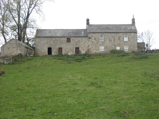
After crossing more soggy fields we turned south east down a metalled road (mile 2) to Chairford Bridge. A sign post headed us east across fields but we called a Herbie Spot after about 3.5 miles and sat in the sun in front of an empty farmhouse that appeared to be under restoration.
 Happy 80th Birthday Doris in Plymouth from the gadgies of Northumberland, Dave, John Ha. Brian John C. and Harry send their best wishes. I am not visible, I have yet to learn how to use the camera timer. We feasted on Pork Pies, yummy chocolate brownies from Mrs A., Apple Turnovers and festive mince pies. Most of us ate sandwiches too.
Fed and coffeed we walked on across the fields to Blakelaw Farm (mile 4) where we joined a road, turned south at Linnheads which has a pretty little lake.

 Linnheads.
Following a signpost we turned right, crossing more soggy fields, a farm road and a disused railway line before cutting across another field and reaching the village of Ridsdale.
 It's a great shame many of these rural lines were closed, they would have made good scenic routes for gadgies.
Ridsdale village has a pub, The Gun and a history. Built for workers in the local coal and iron ore mines it was once used by Lord Armstrong to test his guns too.

 Did Armstrong use it for target practise? It is not a ruined castle but part of the iron works.
Turning right beyond the Gun we walked down a road alongside the old spoil heaps from the iron works, turned left at a junction, crossed the line of Dere Street, the ancient Roman road and shortly afterwards took to the soggy fields again.(mile 8)
The track curved northwards , crossing the dismantled railway again and brought us to Crag Farm.
 Once they built a railroad
 House at Crag Farm with a pyramid roof.
Beyond the farm we passed quarries and a possible ancient burial cairn.
 A possible ancient burial cairn.
More soggy fields and we were at Broadgate overlooking a Roman fort. The final stretch back to West Woodburn on a farm road and, having changed from filthy boots to shoes, straight into the Bay Horse which had a well kept Speckled Hen on draught.
 The outline of Habitancum Roman fort is plainly visible and the ditches outside the wall can be just about seen in this photo, taken as the sun was going down.
Yet another fine gadgie walk, based partly on a "Good Walk" from the Times newspaper but lengthened.
The Matrix MMXVI almost the last.
steps miles
NAK 23442 9.61 (getting better)
Dave's 3D 22530 10.36
"" USB 21786 10.31
"" NAK 21617 10.23
OUTDOOR GPS 10
etrex 10.5
John C 10.6
Brian 10
Walking time 3hr 51 minutes Talking time 1 hour

 Contains OS data. Copyright Crown copyright Database right 2016


 It's that time of year
 Another interesting gate post

 River Rede at dusk
Today's gadgie ramble is centred on East and west Woodburn, which for some reason have been renamed Woodbury, Wood Burn, Woodhorn and Woodstock in organisational emails. Definitely not Woodstock, there are only six of us, not half a million. Nor are we golden but several of us are silver. The team this week consists of John Ha., John C., Brian, Harry, Dave and me. The weather forecast is promising, cold but bright and dry until early evening.
To get to west Woodburn for the start head west on the A69 and turn north near Corbridge on the A68, eventually arriving at the village. There is parking near the pub, The Bay Horse.
A map would be useful, plus archaeological tools. The walk is covered by OS OL 42, Kielder Water and Forest.
(Nothing to do with the walk but there have been many more readers than usual from the USA this week. Tired of the election? Looking for a less lunatic land? Come to England guys, we have Boris and Jeremy.)
The pub was open for breakfast so we indulged in coffee or tea or bacon sandwich or a combination before setting off on the walk. The bacon was said to be excellent, the coffee was fine too.


Leaving the pub we walked a short distance north west up the main street before turning right down a road. After about one third of a mile we took the footpath on the left and walked north east across soggy fields to the bridge across the River Rede.


Having crossed the bridge we turned left, following the marker. (Most of the walk is well posted). We wandered through woodland by the river then uphill through what appeared to be a young orchard, meeting a gentleman immaculately dressed in tweed waistcoat and jacket.
After crossing more soggy fields we turned south east down a metalled road (mile 2) to Chairford Bridge. A sign post headed us east across fields but we called a Herbie Spot after about 3.5 miles and sat in the sun in front of an empty farmhouse that appeared to be under restoration.

Fed and coffeed we walked on across the fields to Blakelaw Farm (mile 4) where we joined a road, turned south at Linnheads which has a pretty little lake.


Following a signpost we turned right, crossing more soggy fields, a farm road and a disused railway line before cutting across another field and reaching the village of Ridsdale.

Ridsdale village has a pub, The Gun and a history. Built for workers in the local coal and iron ore mines it was once used by Lord Armstrong to test his guns too.


Turning right beyond the Gun we walked down a road alongside the old spoil heaps from the iron works, turned left at a junction, crossed the line of Dere Street, the ancient Roman road and shortly afterwards took to the soggy fields again.(mile 8)
The track curved northwards , crossing the dismantled railway again and brought us to Crag Farm.


Beyond the farm we passed quarries and a possible ancient burial cairn.

More soggy fields and we were at Broadgate overlooking a Roman fort. The final stretch back to West Woodburn on a farm road and, having changed from filthy boots to shoes, straight into the Bay Horse which had a well kept Speckled Hen on draught.

Yet another fine gadgie walk, based partly on a "Good Walk" from the Times newspaper but lengthened.
The Matrix MMXVI almost the last.
steps miles
NAK 23442 9.61 (getting better)
Dave's 3D 22530 10.36
"" USB 21786 10.31
"" NAK 21617 10.23
OUTDOOR GPS 10
etrex 10.5
John C 10.6
Brian 10
Walking time 3hr 51 minutes Talking time 1 hour


No comments:
Post a Comment