Walking from Holystone again.....May 20th
This is not a walk, it is an adventure.
(Northumberland)
After the last successful walk from Holystone we are making it a starting point again. The forecast promises an overcast day but no rain until late afternoon, a change from last week's sun. Six gadgies, three Johns, Ben, Dave and me leaving the village for another ramble round Northumberland. Holystone is a village beyond Rothbury, reached by taking the A1 north, the A697 at Morpeth, turning off and going through Rothbury, turning right on the road to Alwinton and then following signs for Holystone.
Use OS OL 16 The Cheviot Hills for the walk. We parked at NT 954027 in the village. No car park, just on the road side. A bit cheeky.
Holystone was home to a Benedictine nunnery opened in 1124 and taken over by Augustinians in the 13th century. The church of St. Mary was the chancel of the nunnery church, some of which is medieval, some the result of 19th century rebuilding.
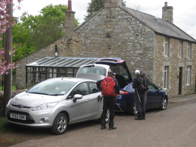 Car parking in the friendly village of Holystone.

Start the walk following the sign post for Forest Walks. (Where there is more parking)
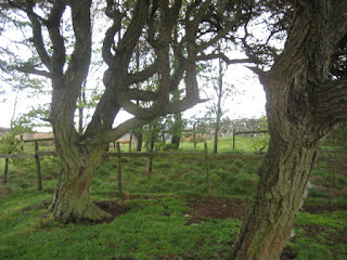
We left the village and followed the track towards the Forest Walks. But having passed St. Mungo's well we took the footpath on the left hand side, crossed a footbridge and followed an almost non existent footpath across fields, Lauder Grass (qv in Glossary), old heather and climbed steadily up to the top of Daw's Hill. Half way up mother nature defied the weather forecast and started to rain, heavily but gadgies can take it and, having donned waterproofs we continued over Daw's Moss and Black Hill to North Yardhope. (mile 3) At this point we followed a finger post on the right that crossed fields and woodland, mostly without markers but John Clarkes trusty GPS led us on.

 Information board at the Herbie Spot
 And one of several strange huts
 Ginger biscuits, hobnobs, other bars, chocolate and pork pies today. Mrs A is in Peru.
Lunch over we followed the path across the road from the dining room and headed northwest along a good rough track to Harbottle Crag, passing a ruined farmhouse on the way, the stonework was quite remarkable.
 Ruined, but solid.
We followed the fence line across Harbottle Crags Nature Reserve, apart from a slight detour to admire a trig point and a couple of round houses for Dave.
 I have turned this through 90 degrees but it is stubborn
 Very old round house.
At mile 6 we turned north east and passed the Drake Stone, a monolith we visited a few weeks ago (Get thee to a nunnery lads) so didn't bother again but continued downhill to Harbottle. A visit to the ruined castle proved well worth the effort of climbing the motte.
 Harbottle lake just before mile 6
 Harbottle village
 Not much left of a castle built for Henry II in 1157 by the Umfravilles. Very active in the border wars that went on for centuries but decayed by the 17th century.
We walked back to the road and through the village, turning off the road at "Harbottle Castle", going down a lane and crossing the River Coquet on a footbridge. By The Peels at mile 8 we spotted the gate on the right that had the ominous sign "Deep Ford Ahead". Nevertheless we followed the footpath across fields to the river. On the bank we decided the water was a bit on the deep side. (In future, John said, bring plastic bags, put them over your boots and cross, quickly). Naughtily we ignored a private no access sign and crossed fields to Sharperton, crossed the river by the road bridge and walked up to Wood Hall. Turning through a farm gate (with finger post) we crossed fields, passed Lady's Well and were back in the village.
 Alpacas at Wood Hall farm
 Lady's Well. An ancient watering hole close to a Roman Road. A sort of service station of its day.
Changed we headed for the Anglers Arms at Weldon Bridge which was very busy but served Speckled Hen, Youngs Gold and Jennings Cumberland. e are always welcomed here, great pub and restaurant and site of the AGM of course.
The Matrix MMXVI R
steps miles
NAK 31620 11.92
3D 29675 11.66
Dave's 3D 25191 11.5
" USB 23485 11.11
" NAK 23076 10.9
OUTDOOR GPS 10.2
eTREX 10.5
Walking time 4h 19 mins hanging around 1 h 57 min
Height climbed 2035 feet
 Contains OS data copyright. Crown copyright and database right 2016
 St Mary, Holystone. It doesn't really lean


This is not a walk, it is an adventure.
(Northumberland)
After the last successful walk from Holystone we are making it a starting point again. The forecast promises an overcast day but no rain until late afternoon, a change from last week's sun. Six gadgies, three Johns, Ben, Dave and me leaving the village for another ramble round Northumberland. Holystone is a village beyond Rothbury, reached by taking the A1 north, the A697 at Morpeth, turning off and going through Rothbury, turning right on the road to Alwinton and then following signs for Holystone.
Use OS OL 16 The Cheviot Hills for the walk. We parked at NT 954027 in the village. No car park, just on the road side. A bit cheeky.
Holystone was home to a Benedictine nunnery opened in 1124 and taken over by Augustinians in the 13th century. The church of St. Mary was the chancel of the nunnery church, some of which is medieval, some the result of 19th century rebuilding.


Start the walk following the sign post for Forest Walks. (Where there is more parking)
We left the village and followed the track towards the Forest Walks. But having passed St. Mungo's well we took the footpath on the left hand side, crossed a footbridge and followed an almost non existent footpath across fields, Lauder Grass (qv in Glossary), old heather and climbed steadily up to the top of Daw's Hill. Half way up mother nature defied the weather forecast and started to rain, heavily but gadgies can take it and, having donned waterproofs we continued over Daw's Moss and Black Hill to North Yardhope. (mile 3) At this point we followed a finger post on the right that crossed fields and woodland, mostly without markers but John Clarkes trusty GPS led us on.

Taking a little shelter from the rain on Daw's Hill.
Having passed a couple of strange looking sheds and several discarded military items we emerged on "The Burma Road". This road has been built for the army. Much of the walk is close to the Otterburn Ranges. There are many signs advising walkers to keep out if red flags are flying and not to pick anything up, as if.
At mile 4 there is an information board describing the delights of the area. It had stopped raining too so we called a Herbie Spot, utilising one small bench and a couple of tree stumps.


Lunch over we followed the path across the road from the dining room and headed northwest along a good rough track to Harbottle Crag, passing a ruined farmhouse on the way, the stonework was quite remarkable.

We followed the fence line across Harbottle Crags Nature Reserve, apart from a slight detour to admire a trig point and a couple of round houses for Dave.


At mile 6 we turned north east and passed the Drake Stone, a monolith we visited a few weeks ago (Get thee to a nunnery lads) so didn't bother again but continued downhill to Harbottle. A visit to the ruined castle proved well worth the effort of climbing the motte.


We walked back to the road and through the village, turning off the road at "Harbottle Castle", going down a lane and crossing the River Coquet on a footbridge. By The Peels at mile 8 we spotted the gate on the right that had the ominous sign "Deep Ford Ahead". Nevertheless we followed the footpath across fields to the river. On the bank we decided the water was a bit on the deep side. (In future, John said, bring plastic bags, put them over your boots and cross, quickly). Naughtily we ignored a private no access sign and crossed fields to Sharperton, crossed the river by the road bridge and walked up to Wood Hall. Turning through a farm gate (with finger post) we crossed fields, passed Lady's Well and were back in the village.


Changed we headed for the Anglers Arms at Weldon Bridge which was very busy but served Speckled Hen, Youngs Gold and Jennings Cumberland. e are always welcomed here, great pub and restaurant and site of the AGM of course.
The Matrix MMXVI R
steps miles
NAK 31620 11.92
3D 29675 11.66
Dave's 3D 25191 11.5
" USB 23485 11.11
" NAK 23076 10.9
OUTDOOR GPS 10.2
eTREX 10.5
Walking time 4h 19 mins hanging around 1 h 57 min
Height climbed 2035 feet


No comments:
Post a Comment