Eight gadgies on a wet day in Allendale.........(Northumberland) Feb 19th
Allendale is a small town in Northumberland, its 19th century prosperity based on local lead mines. It has several pubs and cafes and is the starting point for today's walk. A good turnout, three Johns, H., Ha, and C., Brian, Harry, Dave and me, plus a guest, Dougie who lives locally.
To get to Allendale from base take the A69 west, a few miles beyond Hexham turn left for Alston and after a few more miles watch for signs for Allendale.
A two car job, we met in the Allendale Tea Rooms, a busy cafe which, by all accounts, served a good bacon sandwich. The coffee was fine too.
The walk starts in the town, a map is advisable and the one to use is OS OL 43 Hadrian's Wall.
 Allendale parking area in the town square.
Take the road in the north west corner of the square, pass Peth Cottage and go downhill towards the river East Allen. Just before a bridge there is a footpath on the right which follows the north bank of the east river (confusing) for about a half mile. The path passes some industrial relics and a stone thing with a wren, reminding several of us gadgies of the farthing of childhood.
(Before decimalisation in 1972 when we had proper money; a pound was made up of 240 pennies, divided into 20 shillings, 12 pennies made a shilling. A penny was divided into four, a quarter of a penny being a farthing and it had a wren on it. To be fair they had no value and had dropped out of use but there were 960 to a pound. Nobody had trouble with the money but we had to modernise.
 Probably connected to mining
 Stone thing with wren
 River East Allen
After a half mile the path comes to a road, turn left over the bridge, pausing to admire the Allendale Brewery and then take the footpath on the right which follows the south side of the east river.
 Allendale Brewery

Part of the path on the south side of the east river. The original path, close to the river has been crumbling for years and the recent heavy rains haven't helped.
Leaving the wood the path crosses fields and goes through somebody's garden, although you can, like John C. cut across a field. The cottage garden is beautiful in summer, a bit quiet today.
 The footpath goes right through this garden.
 Approaching Oakpool
Beyond the pretty garden is another cottage, Oakpool. Beyond the buildings turn left and walk up the steep track to the road. Turn right and after a few hundred yards take the path on the left that goes to
 Take this road, it is allowed!


Shetland ponies at Harlow Bower.
Beyond Harlow Bower the path crosses fields to Monk. Good view of Whitfield Hall and Whitfield Church in the valley below.


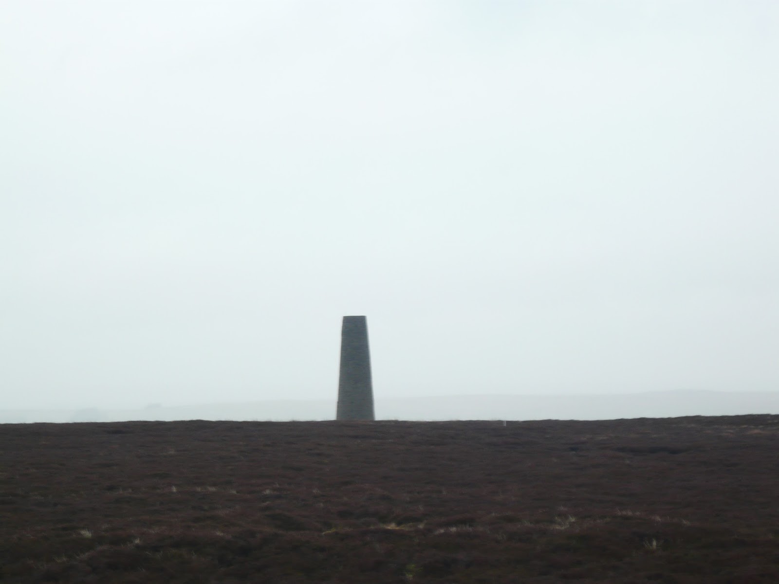
 One of the chimneys
 Remains of the flue which provided draught for the lead smelters. Remarkable structures, best part of a mile long.


There is some overlap.
Contains OS Data copyright Crown copyright and database right 2016
Allendale is a small town in Northumberland, its 19th century prosperity based on local lead mines. It has several pubs and cafes and is the starting point for today's walk. A good turnout, three Johns, H., Ha, and C., Brian, Harry, Dave and me, plus a guest, Dougie who lives locally.
To get to Allendale from base take the A69 west, a few miles beyond Hexham turn left for Alston and after a few more miles watch for signs for Allendale.
A two car job, we met in the Allendale Tea Rooms, a busy cafe which, by all accounts, served a good bacon sandwich. The coffee was fine too.
The walk starts in the town, a map is advisable and the one to use is OS OL 43 Hadrian's Wall.

Take the road in the north west corner of the square, pass Peth Cottage and go downhill towards the river East Allen. Just before a bridge there is a footpath on the right which follows the north bank of the east river (confusing) for about a half mile. The path passes some industrial relics and a stone thing with a wren, reminding several of us gadgies of the farthing of childhood.
(Before decimalisation in 1972 when we had proper money; a pound was made up of 240 pennies, divided into 20 shillings, 12 pennies made a shilling. A penny was divided into four, a quarter of a penny being a farthing and it had a wren on it. To be fair they had no value and had dropped out of use but there were 960 to a pound. Nobody had trouble with the money but we had to modernise.


After a half mile the path comes to a road, turn left over the bridge, pausing to admire the Allendale Brewery and then take the footpath on the right which follows the south side of the east river.


Part of the path on the south side of the east river. The original path, close to the river has been crumbling for years and the recent heavy rains haven't helped.
Leaving the wood the path crosses fields and goes through somebody's garden, although you can, like John C. cut across a field. The cottage garden is beautiful in summer, a bit quiet today.


Beyond the pretty garden is another cottage, Oakpool. Beyond the buildings turn left and walk up the steep track to the road. Turn right and after a few hundred yards take the path on the left that goes to


Shetland ponies at Harlow Bower.
Beyond Harlow Bower the path crosses fields to Monk. Good view of Whitfield Hall and Whitfield Church in the valley below.


Not very good photos of Whitfield Hall and church. It was getting greyer and wetter at this point, just as the local weather forecast had promised.
Shortly after Monk the path contours through a wood and towards the end of this stretch we called a Herbie Spot. (5.5 miles)
Today's treats included lemon slices, iced buns, soft baked cookies, hobnobs, ginger flapjacks from www.cakepoppins.co.uk and chocolate covered biscuits from Mrs A. She has been on holiday, we have missed her cake and biscuits. She is pleased to hear that people as far away as Russia and Canada have read about her offerings.

Hobbit feeding time.
Lunch over we continued on our now wet and very windy way, the gale coming at our sides as we walked across fields which got increasingly muddy too. The path, churned by a million hooves of the local sheep, turned uphill at Keenleyside Hill and met a road. Turn right , at the junction turn left and on the right hand side spot a finger post saying Dryburn Moor. This footpath was very muddy and climbed in a south east direction, in part along what looks like a "Green Lane". It does have markers, and mud, and rain, and a following wind. Eventually the path reaches a road, turn left and after a few hundred yards follow the finger post across the muddy moor past the chimneys, relics of the lead mining days.


The other chimney, too wet and windy to get closer.

Another stretch of flue and distant gadgies.
The footpath becomes a track and eventually joins a metalled road leading down into Allendale. At the only fork take the right road and having crossed the river the road, lined with February Fair Maids, leads back to the town.

Snowdrops
Having removed very muddy boots we headed for the Golden Lion pub in the square. It had a roaring fire and Timothy Taylor's Landlord, what more could a damp and cold gadgie want?
A good walk, hard work because of the weather and the mud but well worth the effort.
In Harry's car on the way home we played "guess the customers" in the Fenham Fish Bar, Cowgate Newcastle upon Tyne. I have explained this before but as a reminder the starter chooses the number of customers he thinks will be in the shop. There are many factors to be taken into consideration, time of day, season, weather and so on. I went for twelve. Player number two must choose a number at least three more or less than the start. Dave chose fifteen, Harry chose nine and we considered he was nearest as we drove by. My wife and daughters think this is a stupid game. It's a gadgie thing.
The matrix MMXVI H
steps miles
LIDL 3D 29266 11.91
NAK 32002 13.63
Dave's 3D 26961 12.41
" USB 26215 11.99
NAK 25948 11.87
etrex GPS 11.91
Walking time 3 hours and 49 minutes
Stopping time 1 hour and 41 minutes (surprising considering the weather)


Contains OS Data copyright Crown copyright and database right 2016
No comments:
Post a Comment