Старbiе роокландс ....Октябра 16(Northumberland)
For some reason I have had a lot of Russian readers lately, or one Russian lots of times or....
The dreaded cold or virus has hit the gadgies hard this week and there are only four of us out walking. For several reasons we have chosen a walk near base, from Alwinton beyond Rothbury, to the deserted farmhouse Old Rooklands. To get to Alwinton, another pretty Northumbrian village with a pub, from Newcastle; A1 north, A697 at Morpeth and follow the diversion signs for Rothbury. (The road is still under repair) Go through Rothbury and turn right at the signpost for Alwinton. On the edge of the village there is a grassed area for parking.
The team today consists of Ray, John H., Dave and me. A map is useful, OS OL 16 The Cheviot Hills and the parking area is at NT922064, approximately.
The forecast is promising, easterly breezes coming all the way from Russia, but not bringing too much cold air, enough for that extra layer as winter approaches.
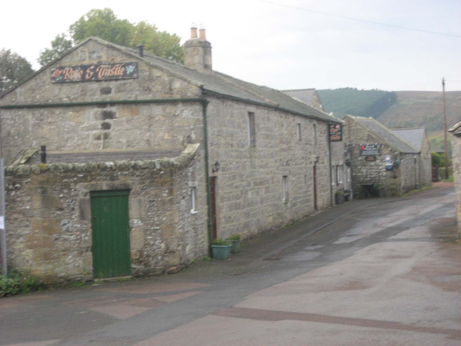
 The Rose and Thistle Public House in Alwinton, it has a nice garden round the back for warm days.
 Alwinton free car park. There is one further down past the pub belonging to the National Park but it is not for Yorkshiremen or Scots.
Next to the car park is a stream, the River Alwin and the walk starts by crossing the footbridge and going uphill on Clennel Street, which is not built up like a street in a town. Clennel Street is an ancient trackway joining Kelso in Scotland to Morpeth in England. Its old name was Ermspeth, Anglo Saxon for "Eagles path", not that there's any eagles about now. Mostly these tracks were used by drovers taking their herds to market in England, now they are used by walkers, mountain bikers and sometimes by motor cyclists. Keeping to the "street" we walked steadily uphill with the fort on Castle Hills on our left, yet another bronze age settlement. After a mile the street goes off to the left, the path we took heads almost directly north. One problem is the increasing use of quad bikes which have created more paths. Ours crosses a "Cross Dyke", an obvious and ancient construction like a boundary wall, but according to our pet archaeologist it was designed to hold horses back.
 There is a fort on this hill, honest.
Reaching the crest of the hill we could see that much of the plantation clearly visible two years ago had been cleared, leaving ugly stumps and scrap timber. We headed down to a stile (mile 2) and turned through almost a semi circle to walk along the valley of the River Alwin, disturbing a heron as we walked. After about a half mile, and having crossed the river we turned east up Rooklands Sike. (Yet another word for a small stream, particularly one that dries up in summer)
We climbed steadily through high and wet bracken, disturbing another heron, and further more it started to rain. We watched out for ticks, Lime disease is on the increase. Eventually we came to Old Rooklands, the tumbledown farmstead that serves as a Herbie Spot.
 It's not much but it serves as a Herbie Spot. Today's offerings were ginger and chocolate biscuits, flapjacks and Mr Kipling's Cherry Tarts. Mrs A comes home this week.

For the ladies of Forest Hall and Goole
Lunch and rain over we continued east along the track which turned south east and eventually came to a minor road. We turned right and almost immediately followed the road as it turned left.After a few hundred yards a signpost on the right directed us diagonally across a field and we emerged on another minor road which took us past the farm at Newton. Quite a large establishment with a farm shop and what seem to be several holiday lets. Just after the farm a signpost on the left sent us across three fields, and along the side of a narrow plantation. (6). Take care if you follow this, the path is marked but is down in a hollow, difficult to spot. Heading south across a couple more fields we came to the farm at Well House.
 Grey day in the Cheviot Hills.
From Well House a farm road goes downhill. In spring the verges are covered with daffodils, but this is October, plant life is falling back. At the Peels (7) we followed The Border County Ride which in places is a muddy track, and all year round too. It passes a fine example of a Lime Kiln.(Nothing to do with disease.) The county is dotted with them, they were once used to make lime for the fields.


Instruction book for the lime kiln at Low Alwinton.
We passed close to a holiday let which had some fine looking cabins, St. Michael and all Angels church and soon found ourselves back in Alwinton.
 St. Michael's. Parts date back to the 12th century but most is 19th century rebuilding.
On the way home we stopped at the dear old Anglers Arms at Weldon Bridge. As welcoming as ever it offered Speckled Hen, Taylor's Golden Best and Courage Directors. All in good condition.
The Matrix MMXV VV
steps miles
LIDL3D 22923 6.94 (Little legs)
etrex 9.08
OUTDOORGPS 8.82
Dave's LIDL3D 20432 8.78
Dave's USB 20066 8.55

Contains OS data Copyright. Crown Copyright and Data Base right 2015
For some reason I have had a lot of Russian readers lately, or one Russian lots of times or....
The dreaded cold or virus has hit the gadgies hard this week and there are only four of us out walking. For several reasons we have chosen a walk near base, from Alwinton beyond Rothbury, to the deserted farmhouse Old Rooklands. To get to Alwinton, another pretty Northumbrian village with a pub, from Newcastle; A1 north, A697 at Morpeth and follow the diversion signs for Rothbury. (The road is still under repair) Go through Rothbury and turn right at the signpost for Alwinton. On the edge of the village there is a grassed area for parking.
The team today consists of Ray, John H., Dave and me. A map is useful, OS OL 16 The Cheviot Hills and the parking area is at NT922064, approximately.
The forecast is promising, easterly breezes coming all the way from Russia, but not bringing too much cold air, enough for that extra layer as winter approaches.

Next to the car park is a stream, the River Alwin and the walk starts by crossing the footbridge and going uphill on Clennel Street, which is not built up like a street in a town. Clennel Street is an ancient trackway joining Kelso in Scotland to Morpeth in England. Its old name was Ermspeth, Anglo Saxon for "Eagles path", not that there's any eagles about now. Mostly these tracks were used by drovers taking their herds to market in England, now they are used by walkers, mountain bikers and sometimes by motor cyclists. Keeping to the "street" we walked steadily uphill with the fort on Castle Hills on our left, yet another bronze age settlement. After a mile the street goes off to the left, the path we took heads almost directly north. One problem is the increasing use of quad bikes which have created more paths. Ours crosses a "Cross Dyke", an obvious and ancient construction like a boundary wall, but according to our pet archaeologist it was designed to hold horses back.

Reaching the crest of the hill we could see that much of the plantation clearly visible two years ago had been cleared, leaving ugly stumps and scrap timber. We headed down to a stile (mile 2) and turned through almost a semi circle to walk along the valley of the River Alwin, disturbing a heron as we walked. After about a half mile, and having crossed the river we turned east up Rooklands Sike. (Yet another word for a small stream, particularly one that dries up in summer)
We climbed steadily through high and wet bracken, disturbing another heron, and further more it started to rain. We watched out for ticks, Lime disease is on the increase. Eventually we came to Old Rooklands, the tumbledown farmstead that serves as a Herbie Spot.


For the ladies of Forest Hall and Goole
Lunch and rain over we continued east along the track which turned south east and eventually came to a minor road. We turned right and almost immediately followed the road as it turned left.After a few hundred yards a signpost on the right directed us diagonally across a field and we emerged on another minor road which took us past the farm at Newton. Quite a large establishment with a farm shop and what seem to be several holiday lets. Just after the farm a signpost on the left sent us across three fields, and along the side of a narrow plantation. (6). Take care if you follow this, the path is marked but is down in a hollow, difficult to spot. Heading south across a couple more fields we came to the farm at Well House.

From Well House a farm road goes downhill. In spring the verges are covered with daffodils, but this is October, plant life is falling back. At the Peels (7) we followed The Border County Ride which in places is a muddy track, and all year round too. It passes a fine example of a Lime Kiln.(Nothing to do with disease.) The county is dotted with them, they were once used to make lime for the fields.
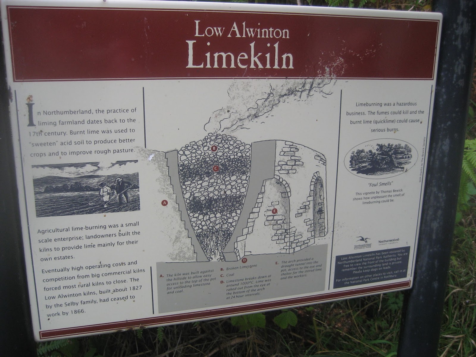

Instruction book for the lime kiln at Low Alwinton.
We passed close to a holiday let which had some fine looking cabins, St. Michael and all Angels church and soon found ourselves back in Alwinton.

On the way home we stopped at the dear old Anglers Arms at Weldon Bridge. As welcoming as ever it offered Speckled Hen, Taylor's Golden Best and Courage Directors. All in good condition.
The Matrix MMXV VV
steps miles
LIDL3D 22923 6.94 (Little legs)
etrex 9.08
OUTDOORGPS 8.82
Dave's LIDL3D 20432 8.78
Dave's USB 20066 8.55

Contains OS data Copyright. Crown Copyright and Data Base right 2015
No comments:
Post a Comment