Three cairns on a mountain....... February 21st.
The young lady who shares the weather forecasting with the jolly jock on local TV assured us the day would be showery, but light ones, with a fairly strong wind and a lower temperature than Thursday. She was just about right but the showers were a bit heavy at times.
So we set out to walk from Rothbury in Northumberland. A small town, the capital of Coquetdale, Rothbury gets its name from Hrotha's burg, Old English for Hrotha's Fort. The town has a good number of iron age forts in the hills around it and some of the mysterious cup and ring markings. It had a church, All Saints, with a pre conquest tower but a vandalising, vicious, Victorian vicar had it pulled down and rebuilt. (Alliteration!)
To get to Rothbury take the A1 north, turn off at the A697, heading north and follow the diversion signs to the town, the road is still not repaired. Would it take so long in Buckingham I ask?
We called in at Tomlinsons Cafe and Bunkhouse for a slow breakfast as it was raining. Some had a five flitch bacon roll. (look them up on www.tomlinsonsrothbury.co.uk)
 Park on the street for a change
 Tomlinsons Rothbury, super cafe


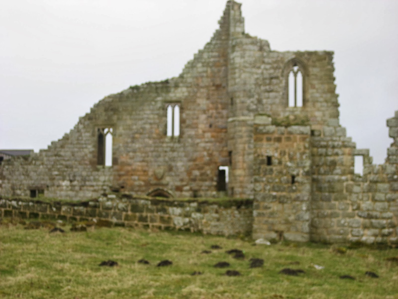
Ruins of Cartington Castle. First recorded in 1154 the king gave a licence to crennelate in 1442. In 1515 Queen Margaret of Scotland stayed for a while. In the English Civil War it was a Royalist stronghold and held off a besieging Parliamentary army for two hours. Abandoned in 1860 Lord Armstrong had some repairs done in 1867 but it's a ruin now.
We walked in front of Cartington Farm, admiring the topiary and headed north on the metalled road spotting a pair of Great Spotted Woodpeckers on the way.
 Topiary at Cartington.
After a mile on the road, passing Bankhead Farm and Kennels we turned right up a track alongside a stream and decided to make a Herbie Spot. Oh what a feast, sandwiches, Ringtons Ginger Biscuits, Hobnobs, caramel slices, individual Bramley Apple pies and Mrs A's excellent tomato cake! This must stop!

John struggles after the Herbie Feast.
Continuing along the track until we came to a field we followed the edge of a plantation which had been recently felled for the best part of a mile (6 on the map) until we came to a sign post that led us south in the direction of Cartington Hill.
 A real stile

Heather covered Cartington Hill.
The hill is not particularly steep for gadgies but after a couple of muddy fields the path disappeared in the heather. Heather is difficult to walk on, there are hidden pot holes and straggly bits to trip you up, but it does clean the mud off your boots. It has two summits with cairns containing, once, the remains of local chiefs and there is a third burial cairn below one summit.
 Cairn on Cartington Hill. These are
not the three chiefs.
At the bottom of the hill we turned left on a good track, disturbing four roe deer which bounced away over the heather. Eventually we came to a plantation, A sign post pointed to the right saying Rothbury 3.5 miles. ( If you follow this wakk ignore it and continue down hill to a cross roads with a sign to the right saying Rothbury 1.25 miles, take this one.) A short way along the track we found the marker directing us across muddy fields to Rothbury. At the next plantation we turned left and walked along a track which became a steep and muddy path but it eventually led us back to the town.
 The capital of Coquetdale, Rothbury
On the way home we stuck to tradition and called in at The Anglers Arms, Weldon Bridge, which was serving Timothy Taylor's Golden Best, Wells Bombardier and Everards Tiger. We wished we were staying for a second AGM. John appears to have an obsession with the pub's decoration, admiring the large white and blue ceramic cats on the mantle piece, although I suggested they were kitsch.
Brian pointed out that a real example of something popular and vulgar was that well known chocolate biscuit the Kitsch Kat. Give us a break Brian;
John has suggested a new category, clarts, as an indication of mud.
On a scale of 0 to 5 this one gets a 3 today.
Good day for the birders, woodpeckers, buzzards, long tailed tits, coal tits, blue tits, kestrel and a heron. However the beast of the blog goes to the deer for demonstrating how to cross hesther moors.

Deer on the run Reminds me of a joke about
naming Native Americans
The Matrix MMXIVF
steps miles
Higear behaved disgracefully
LIDL3D 24638 11.1
Dave's LIDL3D 23992 11.05
LIDLUSB 22945 10.86
OUTDOORS GPS 10.25
Brian's GPS 10.25
Pretty good.
Gadgie distance 85 miles


The young lady who shares the weather forecasting with the jolly jock on local TV assured us the day would be showery, but light ones, with a fairly strong wind and a lower temperature than Thursday. She was just about right but the showers were a bit heavy at times.
So we set out to walk from Rothbury in Northumberland. A small town, the capital of Coquetdale, Rothbury gets its name from Hrotha's burg, Old English for Hrotha's Fort. The town has a good number of iron age forts in the hills around it and some of the mysterious cup and ring markings. It had a church, All Saints, with a pre conquest tower but a vandalising, vicious, Victorian vicar had it pulled down and rebuilt. (Alliteration!)
To get to Rothbury take the A1 north, turn off at the A697, heading north and follow the diversion signs to the town, the road is still not repaired. Would it take so long in Buckingham I ask?
We called in at Tomlinsons Cafe and Bunkhouse for a slow breakfast as it was raining. Some had a five flitch bacon roll. (look them up on www.tomlinsonsrothbury.co.uk)
and bunkhouse.
The walk; a map is advisable and the one to use is OS Explorer 332 Alnwick and Amble and Tomlinsons is on the corner of Bridge Street at NU058016
From the cafe we walked back to the high street and admired the sausages in the butcher's window on the north side of the road. Turning west we found the alley (ginnel, passage or lane that led us between houses to a road, turning right and almost immediately left we continued the steep climb until we were out bin open country. Turning left at the first junction we followed a muddy path until it joined a more substantial track. We followed the track for the best part of a mile before spotting the footpath on the left (marked) which led us down to a wood. There were several patches of snowdrops in the wood.
February Fair Maids.
Emerging from the wood onto a track we turned left and at South Cartington we turned right and after crossing a couple of fields came to Cartington Castle.
We walked in front of Cartington Farm, admiring the topiary and headed north on the metalled road spotting a pair of Great Spotted Woodpeckers on the way.
After a mile on the road, passing Bankhead Farm and Kennels we turned right up a track alongside a stream and decided to make a Herbie Spot. Oh what a feast, sandwiches, Ringtons Ginger Biscuits, Hobnobs, caramel slices, individual Bramley Apple pies and Mrs A's excellent tomato cake! This must stop!
John struggles after the Herbie Feast.
Continuing along the track until we came to a field we followed the edge of a plantation which had been recently felled for the best part of a mile (6 on the map) until we came to a sign post that led us south in the direction of Cartington Hill.
Heather covered Cartington Hill.
The hill is not particularly steep for gadgies but after a couple of muddy fields the path disappeared in the heather. Heather is difficult to walk on, there are hidden pot holes and straggly bits to trip you up, but it does clean the mud off your boots. It has two summits with cairns containing, once, the remains of local chiefs and there is a third burial cairn below one summit.
not the three chiefs.
At the bottom of the hill we turned left on a good track, disturbing four roe deer which bounced away over the heather. Eventually we came to a plantation, A sign post pointed to the right saying Rothbury 3.5 miles. ( If you follow this wakk ignore it and continue down hill to a cross roads with a sign to the right saying Rothbury 1.25 miles, take this one.) A short way along the track we found the marker directing us across muddy fields to Rothbury. At the next plantation we turned left and walked along a track which became a steep and muddy path but it eventually led us back to the town.
On the way home we stuck to tradition and called in at The Anglers Arms, Weldon Bridge, which was serving Timothy Taylor's Golden Best, Wells Bombardier and Everards Tiger. We wished we were staying for a second AGM. John appears to have an obsession with the pub's decoration, admiring the large white and blue ceramic cats on the mantle piece, although I suggested they were kitsch.
Brian pointed out that a real example of something popular and vulgar was that well known chocolate biscuit the Kitsch Kat. Give us a break Brian;
John has suggested a new category, clarts, as an indication of mud.
On a scale of 0 to 5 this one gets a 3 today.
Good day for the birders, woodpeckers, buzzards, long tailed tits, coal tits, blue tits, kestrel and a heron. However the beast of the blog goes to the deer for demonstrating how to cross hesther moors.
Deer on the run Reminds me of a joke about
naming Native Americans
The Matrix MMXIVF
steps miles
Higear behaved disgracefully
LIDL3D 24638 11.1
Dave's LIDL3D 23992 11.05
LIDLUSB 22945 10.86
OUTDOORS GPS 10.25
Brian's GPS 10.25
Pretty good.
Gadgie distance 85 miles
No comments:
Post a Comment