Clarty and claggy .......................December 20th
Clarty and claggy are two delightful North East Dialect words that sum up this walk, a rerun of the John Martin Trail that has been covered at least twice before.
Clarty means muddy and claggy means sticky, clart without the y is mud, and most of the day's walk was in it.
Because of Christmas when people tend to travel to see family or have family visiting today's walkers are reduced to three unwanted gadgies, Brian, John and me. The walk starts at Haydon Bridge and is covered by OS OL 43, Hadrian's Wall. Travel west from Newcastle on the A69, turn off for Haydon Bridge on the A686 but do not cross the Tyne. Before the river turn left and follow the road past the Anchor Hotel and turn sharp left at the Haydonite Club. Just beyond the Shaftoe School there is a small (free) car park at NY844640.
As a reminder John Martin (1789 1854) was an artist born in these parts and famous for his huge canvasses, often with biblical themes. His brother Jonathon set fire to York Minster and was sent to the local asylum.
We stopped for breakfast at the café in the large car park in Hexham; true to my promise I had a pot of tea and no bacon sandwich.

A car park again, Shaftoe school behind.
The walk;
We walked downhill from the car park and, almost directly opposite the Haydonite, followed the road past a few houses, a caravan site and the East Land Ends farm where the great man was born.
 John Martin's birthplace, his mum and
dad probably didn't have the conservatory
in 1789.
We stayed on the farm road as far as Lees Farm, which has plenty of dogs and went through the yard, following the markers for the walk.
 Lees farm

Watch out for the markers, they are useful.
Through the farmyard the path crosses four muddy fields before hitting the road which goes to Tedcastle. We turned left and after a few hundred yards turned right on a road which goes downhill. After a few hundred yards we followed the heritage trail through a gate on the left (marker vanished!) and walked across a muddy field to Morrallee Woods, a National Trust property, currently being cleared of rhododendrons which can become a bit of a nuisance. If you follow this walk watch out for the John Martin trail markers as there are several other walks in the woods. The JM trail goes steeply down to the banks of the River Allen, crosses a field, goes through another short stretch of wood, and emerges onto a road which leads to Plankey Mill.
Plankey Mill means, possibly, the neck of floodable land where games are played, according to the book of Northumbrian place names. First recorded in 1673 and known as Naked ale or ele,
naked meaning neck and ele being an island.
 Plankey Mill Farm
 Field at Plankey Mill,
a popular picnic spot in summer
and a pleasant Herbie Spot today.
We called a halt for lunch; today's offerings were a mince pie, a Dorset Cereal Bar and a slice of Mrs. A's Apple cake. So much for the diet.
Lunch over we walked along the river bank over two fields before re-entering the National Trust property of Allen Banks.
 Quite possibly the driest part of the walk.
 The River Allen
 Again.
After a while the path climbs steeply towards Staward Peel. The footpath has been "stepped" in places, just as well on a clarty day or it would be two forwards and one back.
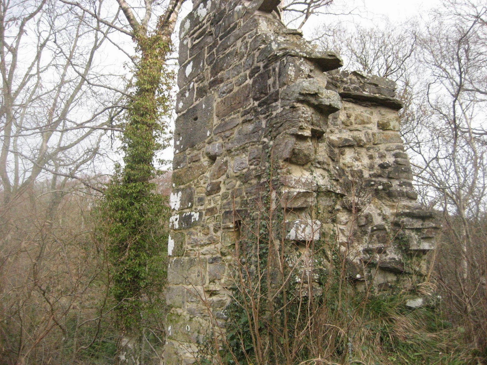
The peel is in a very commanding position, built on a peninsula with steep banks on either side, not that there is much left now.
 Remains of the peel
 And its gate house

 Harsondale


Clarty and claggy are two delightful North East Dialect words that sum up this walk, a rerun of the John Martin Trail that has been covered at least twice before.
Clarty means muddy and claggy means sticky, clart without the y is mud, and most of the day's walk was in it.
Because of Christmas when people tend to travel to see family or have family visiting today's walkers are reduced to three unwanted gadgies, Brian, John and me. The walk starts at Haydon Bridge and is covered by OS OL 43, Hadrian's Wall. Travel west from Newcastle on the A69, turn off for Haydon Bridge on the A686 but do not cross the Tyne. Before the river turn left and follow the road past the Anchor Hotel and turn sharp left at the Haydonite Club. Just beyond the Shaftoe School there is a small (free) car park at NY844640.
As a reminder John Martin (1789 1854) was an artist born in these parts and famous for his huge canvasses, often with biblical themes. His brother Jonathon set fire to York Minster and was sent to the local asylum.
We stopped for breakfast at the café in the large car park in Hexham; true to my promise I had a pot of tea and no bacon sandwich.

A car park again, Shaftoe school behind.
The walk;
We walked downhill from the car park and, almost directly opposite the Haydonite, followed the road past a few houses, a caravan site and the East Land Ends farm where the great man was born.

dad probably didn't have the conservatory
in 1789.
We stayed on the farm road as far as Lees Farm, which has plenty of dogs and went through the yard, following the markers for the walk.


Watch out for the markers, they are useful.
Through the farmyard the path crosses four muddy fields before hitting the road which goes to Tedcastle. We turned left and after a few hundred yards turned right on a road which goes downhill. After a few hundred yards we followed the heritage trail through a gate on the left (marker vanished!) and walked across a muddy field to Morrallee Woods, a National Trust property, currently being cleared of rhododendrons which can become a bit of a nuisance. If you follow this walk watch out for the John Martin trail markers as there are several other walks in the woods. The JM trail goes steeply down to the banks of the River Allen, crosses a field, goes through another short stretch of wood, and emerges onto a road which leads to Plankey Mill.
Plankey Mill means, possibly, the neck of floodable land where games are played, according to the book of Northumbrian place names. First recorded in 1673 and known as Naked ale or ele,
naked meaning neck and ele being an island.


a popular picnic spot in summer
and a pleasant Herbie Spot today.
We called a halt for lunch; today's offerings were a mince pie, a Dorset Cereal Bar and a slice of Mrs. A's Apple cake. So much for the diet.
Lunch over we walked along the river bank over two fields before re-entering the National Trust property of Allen Banks.


After a while the path climbs steeply towards Staward Peel. The footpath has been "stepped" in places, just as well on a clarty day or it would be two forwards and one back.
The peel is in a very commanding position, built on a peninsula with steep banks on either side, not that there is much left now.


Could have been impressive, once.
The footpath from the peel led us along a narrow path, be warned if you have small children with you and emerges into a field. We crossed the field and found the stile that took us into a wood with a steep path that led downhill, across a footbridge and up the other side, this path was very slippy because of the clarts which were claggy. Across another field and we came to the next farm, Harsondale, crossing a stile and turning right on the farm road.
Somewhere along this road Brian broke through his total walking mileage for last year, he had forgotten to bring a hip flask to celebrate, sad.


An artistic shot of trees.
At a point along this road a public footpath marker will take you
to Sillywrae, a farm that still relies on horsepower to carry out the work, but we continued on the track until we came to a road and turned left. Reaching a junction we took the marked path directly opposite the track we had walked which took us down to the farm at West Deanraw. At the next junction we turned right but instead of following this road to Langley Castle we took the footpath across a field to Black Byre Plantation which surpassed anything we had seen for clarts. Another footpath, another field and we were at West Land Ends, another farm, with a classy hemel.

The hemel at West Land Ends farm.
Following the road we were soon passing East Land End again and were soon back at the car.
It was only 3.15pm. On the way home we called in at the Boathouse pub in Wylam, it had its usual large selection of hand pulled ales on offer.
The Matrix
Total disaster, Higear decided its battery was finished andLIDL3D defcided to shut down at the Herbie spot.
However Outdoor GPS gave a distance of 9.3 miles and Brian's GPS said 9.6.
Not a great day for birds but we saw a heron, a buzzard and probably a barn owl.

This map of the walk is from the
John Martin Heritage leaflet available
in the town and I shall probably
be in trouble for using it.

This map is from OUTDOOR GPS
and OS say I can publish it if I give
them credit, which I have.

And this is Sadak searching for the waters
of oblivion. Why didn't he just go to the pub?

Gadgie walking total for the year: 462.6 miles. Must do better in 2014
This is the last walk of the year and therefore the last blog until January 3rd 2014 so a merry Christmas and Happy New year, let's hope it's a good one without any fear as John sang. And to quote that great Irish comedian Dave Allen, may your God go with you.
No comments:
Post a Comment